Showing 10685 items matching "east melbourne"
-
 Eltham District Historical Society Inc
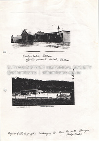
Document - Property Binder, 825 Main Road, Eltham
Photocopy photographs Evelyn Hotel Eltham and Eltham Swimming Pool, images owned by Garreth Burges. Elevations west, north, south, east, of proposed development by Germano Architects. Floor plans of proposed development by Germano Architects. Newspaper article: Council to reject apartments plan, Diamond Valley News, 20 May 1998, Nillumbik Council meeting, protestors against 25 unit development from Eltham Gateway Action Group. Newspaper public notice: Diamond Valley Leader 1 March 2006, Notice of Application for a Planning Permit, by Germano Architects. Newspaper article: Building at long last, Diamond Valley Leader, 3 September 2008, Nillumbik Council approved development plans.main road, eltham, property, businesses, evelyn hotel eltham, eltham swimming pool, eltham gateway action group, germano architects -
 Eltham District Historical Society Inc
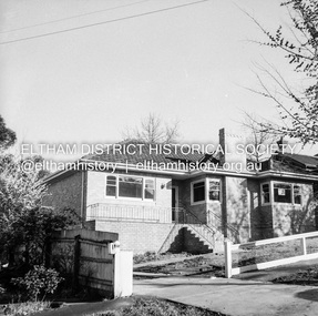
Negative - Photograph, J.A. McDonald, Newly built home, Sep. 1955
Street and location unidentified, possibly not Eltham though next immediate frame is Pryor Street and sun position appears to be similar indicating street (ealrly to mid afternoon) indicating street runs east west direction and camera view is to the south. Streets in Eltham are all even numbered on the south sideRecord of various Shire of Eltham infrastructure works undertaken during the period of 1952-1962 involving bridge and road reconstruction projects, sometimes with Eltham Shire Council Project Reference numbers quoted. It was during this period that a number of significant improvements were made to roads and new bridges constructed within the shire that remain in place as of present day (2022). In many situations, the photos provide a tangible visible record of infrastructure that existed throughout the early days of the Shire. The album was put together by or under the direction of the Shire Engineer, J.A. McDonald.1955-09, houses, shire of eltham -
 Eltham District Historical Society Inc
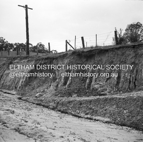
Negative - Photograph, J.A. McDonald, Heidelberg-Kinglake Road, Sep 1959
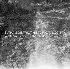
Job 56M430 Contractor Hone Just south of east abutment and access road to house showing block in table drain and wash towards Diamond CreekRecord of various Shire of Eltham infrastructure works undertaken during the period of 1952-1962 involving bridge and road reconstruction projects, sometimes with Eltham Shire Council Project Reference numbers quoted. It was during this period that a number of significant improvements were made to roads and new bridges constructed within the shire that remain in place as of present day (2022). In many situations, the photos provide a tangible visible record of infrastructure that existed throughout the early days of the Shire. The album was put together by or under the direction of the Shire Engineer, J.A. McDonald.infrastructure, shire of eltham, bridge construction, 1959-09, heidelberg-kinglake road, road construction -
 Eltham District Historical Society Inc
Negative - Photograph, J.A. McDonald, Heidelberg-Kinglake Road, Sep 1959
Job 56M430 Contractor Hone Heavy rain washed out the east abutment and access road to house 19-20 September 1959Record of various Shire of Eltham infrastructure works undertaken during the period of 1952-1962 involving bridge and road reconstruction projects, sometimes with Eltham Shire Council Project Reference numbers quoted. It was during this period that a number of significant improvements were made to roads and new bridges constructed within the shire that remain in place as of present day (2022). In many situations, the photos provide a tangible visible record of infrastructure that existed throughout the early days of the Shire. The album was put together by or under the direction of the Shire Engineer, J.A. McDonald.infrastructure, shire of eltham, bridge construction, 1959-09, heidelberg-kinglake road, road construction -
 Eltham District Historical Society Inc
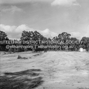
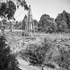
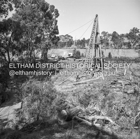
Negative - Photograph, J.A. McDonald, Reconstruction works, Research Oval, Jan. 1961
... melbourne At commencement, looking east Early January 1961 Record ...At commencement, looking east Early January 1961Record of various Shire of Eltham infrastructure works undertaken during the period of 1952-1962 involving bridge and road reconstruction projects, sometimes with Eltham Shire Council Project Reference numbers quoted. It was during this period that a number of significant improvements were made to roads and new bridges constructed within the shire that remain in place as of present day (2022). In many situations, the photos provide a tangible visible record of infrastructure that existed throughout the early days of the Shire. The album was put together by or under the direction of the Shire Engineer, J.A. McDonald.shire of eltham, 1961-01, infrastructure, reconstruction works, research (vic.), research oval -
 Eltham District Historical Society Inc
Negative - Photograph, J.A. McDonald, Henley Road at Watsons Creek, Apr. 1961
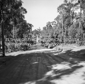
Henley Road at Watsons Creek looking westerly along centreline from east abutment Early April 1961Record of various Shire of Eltham infrastructure works undertaken during the period of 1952-1962 involving bridge and road reconstruction projects, sometimes with Eltham Shire Council Project Reference numbers quoted. It was during this period that a number of significant improvements were made to roads and new bridges constructed within the shire that remain in place as of present day (2022). In many situations, the photos provide a tangible visible record of infrastructure that existed throughout the early days of the Shire. The album was put together by or under the direction of the Shire Engineer, J.A. McDonald.infrastructure, shire of eltham, bend of islands, cr. charis pelling, henley road, henley road bridge, kangaroo ground, oxley bridge, watsons creek, w.e. wolf, bridge construction, road construction, 1961-04 -
 Eltham District Historical Society Inc
Negative - Photograph, J.A. McDonald, Henley Road at Watsons Creek, Apr. 1961
Henley Road at Watsons Creek looking westerly along centreline from east abutment Early April 1961Record of various Shire of Eltham infrastructure works undertaken during the period of 1952-1962 involving bridge and road reconstruction projects, sometimes with Eltham Shire Council Project Reference numbers quoted. It was during this period that a number of significant improvements were made to roads and new bridges constructed within the shire that remain in place as of present day (2022). In many situations, the photos provide a tangible visible record of infrastructure that existed throughout the early days of the Shire. The album was put together by or under the direction of the Shire Engineer, J.A. McDonald.infrastructure, shire of eltham, bend of islands, cr. charis pelling, henley road, henley road bridge, kangaroo ground, oxley bridge, watsons creek, w.e. wolf, bridge construction, road construction, 1961-04 -
 Eltham District Historical Society Inc
Negative - Photograph, J.A. McDonald, Rattray Road East, Montmorency, 1 May 1961
... melbourne Rattray Road East Taken from opposite No. ? Looking ...Rattray Road East Taken from opposite No. ? Looking eastwards from Looker Road end taken from near rear entrance to Delbridge 1 May 1961Record of various Shire of Eltham infrastructure works undertaken during the period of 1952-1962 involving bridge and road reconstruction projects, sometimes with Eltham Shire Council Project Reference numbers quoted. It was during this period that a number of significant improvements were made to roads and new bridges constructed within the shire that remain in place as of present day (2022). In many situations, the photos provide a tangible visible record of infrastructure that existed throughout the early days of the Shire. The album was put together by or under the direction of the Shire Engineer, J.A. McDonald.1961-05-01, infrastructure, montmorency, rattray road, road construction, shire of eltham -
 Eltham District Historical Society Inc
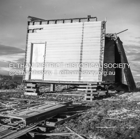
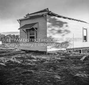
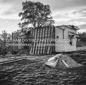
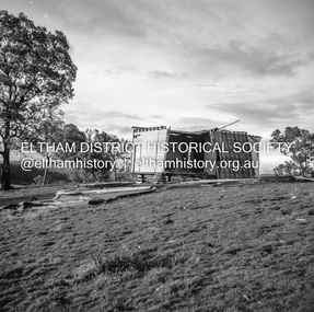
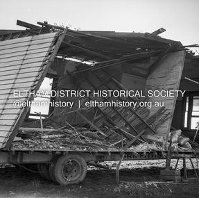
Negative - Photograph, J.A. McDonald, Inspection of storm damaged Abraham house at Kangaroo Ground, c. May 1962
Showing the effect of a wind storm that destroyed the house circa May 1962.. The Abraham family owned land near the Aqueduct and east of Nicholas Lane at Kangaroo Ground (based on photos, at or near 40 Nicholas Lane).Record of various Shire of Eltham infrastructure works undertaken during the period of 1952-1962 involving bridge and road reconstruction projects, sometimes with Eltham Shire Council Project Reference numbers quoted. It was during this period that a number of significant improvements were made to roads and new bridges constructed within the shire that remain in place as of present day (2022). In many situations, the photos provide a tangible visible record of infrastructure that existed throughout the early days of the Shire. The album was put together by or under the direction of the Shire Engineer, J.A. McDonald.1962-05, abraham house, kangaroo ground, nicholas lane, property damage, storm damage -
 Eltham District Historical Society Inc
Negative - Photograph, J.A. McDonald, Inspection of storm damaged Abraham house at Kangaroo Ground, c. May 1962
Showing the effect of a wind storm that destroyed the house circa May 1962.. The Abraham family owned land near the Aqueduct and east of Nicholas Lane at Kangaroo Ground (based on photos, at or near 40 Nicholas Lane).Record of various Shire of Eltham infrastructure works undertaken during the period of 1952-1962 involving bridge and road reconstruction projects, sometimes with Eltham Shire Council Project Reference numbers quoted. It was during this period that a number of significant improvements were made to roads and new bridges constructed within the shire that remain in place as of present day (2022). In many situations, the photos provide a tangible visible record of infrastructure that existed throughout the early days of the Shire. The album was put together by or under the direction of the Shire Engineer, J.A. McDonald.1962-05, abraham house, kangaroo ground, nicholas lane, property damage, storm damage, building surveyor, george e. newton -
 Eltham District Historical Society Inc
Negative - Photograph, J.A. McDonald, Inspection of storm damaged Abraham house at Kangaroo Ground, c. May 1962
Showing the effect of a wind storm that destroyed the house circa May 1962.. The Abraham family owned land near the Aqueduct and east of Nicholas Lane at Kangaroo Ground (based on photos, at or near 40 Nicholas Lane).Record of various Shire of Eltham infrastructure works undertaken during the period of 1952-1962 involving bridge and road reconstruction projects, sometimes with Eltham Shire Council Project Reference numbers quoted. It was during this period that a number of significant improvements were made to roads and new bridges constructed within the shire that remain in place as of present day (2022). In many situations, the photos provide a tangible visible record of infrastructure that existed throughout the early days of the Shire. The album was put together by or under the direction of the Shire Engineer, J.A. McDonald.1962-05, abraham house, kangaroo ground, nicholas lane, property damage, storm damage -
 Eltham District Historical Society Inc
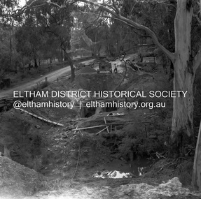
Negative - Photograph, J.A. McDonald, One Tree Hill Road Bridge, Christmas Hills, 2 July 1962
One Tree Hill Road Looking south 2/7/62 The bridge was destroyed by bushfires 15-16 January 1962. A temporary bridge was set up to the east sideRecord of various Shire of Eltham infrastructure works undertaken during the period of 1952-1962 involving bridge and road reconstruction projects, sometimes with Eltham Shire Council Project Reference numbers quoted. It was during this period that a number of significant improvements were made to roads and new bridges constructed within the shire that remain in place as of present day (2022). In many situations, the photos provide a tangible visible record of infrastructure that existed throughout the early days of the Shire. The album was put together by or under the direction of the Shire Engineer, J.A. McDonald.1962-07-02, bridge construction, christmas hills, infrastructure, shire of eltham, victorian bushfires - 1962, bush fires, one tree hill road, property damage -
 Eltham District Historical Society Inc
Negative - Photograph, J.A. McDonald, Laidlays Road, Arthurs Creek, April 1962
Bridge over Arthurs Creek Looking east April 1962Record of various Shire of Eltham infrastructure works undertaken during the period of 1952-1962 involving bridge and road reconstruction projects, sometimes with Eltham Shire Council Project Reference numbers quoted. It was during this period that a number of significant improvements were made to roads and new bridges constructed within the shire that remain in place as of present day (2022). In many situations, the photos provide a tangible visible record of infrastructure that existed throughout the early days of the Shire. The album was put together by or under the direction of the Shire Engineer, J.A. McDonald.1962-04, arthurs creek, bridge construction, infrastructure, laidlays road, shire of eltham -
 Eltham District Historical Society Inc
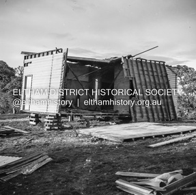
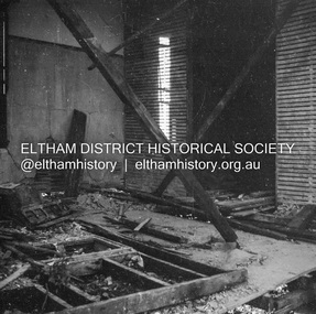
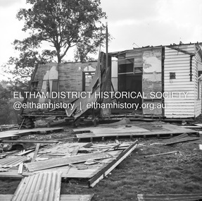
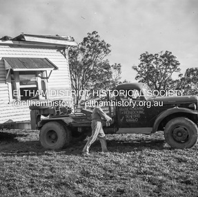
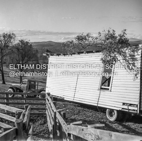
Negative - Photograph, J.A. McDonald, Removal of the remains of the Abraham house at Kangaroo Ground, c. May 1962
Martin Bros House Removing of Seaford was contracted to remove the remains of the storm damaged Abraham house from the property circa May 1962. The Abraham family owned land near the Aqueduct and east of Nicholas Lane at Kangaroo Ground (based on photos, at or near 40 Nicholas Lane).Record of various Shire of Eltham infrastructure works undertaken during the period of 1952-1962 involving bridge and road reconstruction projects, sometimes with Eltham Shire Council Project Reference numbers quoted. It was during this period that a number of significant improvements were made to roads and new bridges constructed within the shire that remain in place as of present day (2022). In many situations, the photos provide a tangible visible record of infrastructure that existed throughout the early days of the Shire. The album was put together by or under the direction of the Shire Engineer, J.A. McDonald.1962-05, abraham house, kangaroo ground, martin bros house removing seaford, nicholas lane, property damage -
 Eltham District Historical Society Inc
Slide - Photograph, Eltham Shire Council, Plan of Subdivision, Part of Crown Allotments 5 & 6, Section 10, Parish of Nillumbik, County of Evelyn (Foster Road, Eltham East), 1969
35mm colour positive transparency blue Agfacolour Service plastic mountC5(a) DU (Vic) D/L Foster Road, Eltham East, 4 August 1969infrastructure, map, planning, subdivison lots, abersham court, ancona close, eltham east, floriston grove, foster road, frank street, gladwyn court -
 Eltham District Historical Society Inc
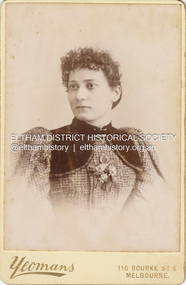
Photograph, Caroline (Carrie) Shillinglaw, c.1895
Caroline Shillinglaw married Christopher Watson 1907. Their daughter, Jean, was born 1906. Yeoman & Co operated from 116 Bourke Street East from c.1889-1910+ CABINET 1866-1905 The Cabinet photo was introduced in 1866 in answer to a demand for a larger format photograph which could be mounted for a cabinet or on the wall. They were 4.5 inches by 6.5 inches (11.5 x 16.5 cm), more than twice the size of the cdv. They cost about twice as much as a cdv but eventually displaced them. They were not extensively produced until 1880 and had ceased by 1905. Coloured mounts, especially maroon or green, indicate a date between 1880 and 1890. - Frost, Lenore; Dating Family Photos 1850-1920; Valiant Press Pty. Ltd., Berwick, Victoria 1991cabinet photo, marg ball collection, shillinglaw family photo album 3, 1889-1910, 1895, caroline (carrie) watson (nee shillinglaw) 1876-1956, yeomans photographers 116 bourke st. east -
 Eltham District Historical Society Inc
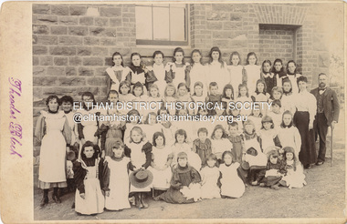
Photograph, Theodor Black, Girl Students, Eltham State School No. 209, c.1904
Photo taken at the east end of the school. 1. Head Teacher John Brown served as HT from 1889 to his death in Sept 1906. 2. 53 Girls and 42 boys - 95 - attendance figures known between 1899 and 1906. 3. Female teacher in both photohraphs is Miss Amy E Barrowclough (Oct 1900 through 1904) [150th anniversary book incorrectly identifies her as Ellen Sweeney] 4. Youth in doorway is the Monitor, Harold Gilsenan (1904) 5. Post and rail fencing along Dalton Street (seen behind John Brown) was built in the upgrade of 1903 These facts date the photographs to be c.1904-c.1905 [Harry Gilham] Ina Falkiner is top row 4th from left Gertrude Falkiner is bottom row seated 4th from left. (Identified by Gertrude's garnddaugher and Ina's great neice, Judith Vun, email 26 May 2022) John Brown died 23 Sept 1906 after a short severe illness at age 55 and is buried in Box Hill Cemetery (Evelyn Observer 28 Sep 1906 p2). The book "We did open a school in Little Eltham" incorrectly states his date of death as 16/12/1906. Title The Evelyn Observer. (1906, September 28). Evelyn Observer and Bourke East Record (Vic. : 1902 - 1917), p. 2 (MORNING.) Url http://nla.gov.au/nla.news-article61129880 Description It is with sincere regret we record the death of Mr. John Brown, State school teacher, Eltham, which sad event took place at his residence, "Pine Brae," on Sunday night last, 23rd inst. after a severe illness of some few weeks' duration. The deceased gentleman was highly respected, and always took a lively and active interest in promoting the progress and prosperity of the district, and his loss will be much felt, He was only 55 years of age, and leaves a wife and large family to mourn their loss, and much sympathy is felt for them. The remains of the deceased were interred in the Box Hill cemetery on Wednesday afternoon last. PANEL 1875-1920 Panels began to be produced around 1875, and were particularly suited, because of their larger size, for capturing family, or even larger, groups. They measured 8.5 by 6.5 inches (22 cm x 16.5 cm). - Frost, Lenore; Dating Family Photos 1850-1920; Valiant Press Pty. Ltd., Berwick, Victoria 1991marg ball collection, shillinglaw family photo album 3, class photo, eltham primary school, eltham state school no. 209, 1904, gretrude falkiner, ina falkiner, john brown, miss amy e barrowclough, state school no. 209, theodor black photographer -
 Eltham District Historical Society Inc
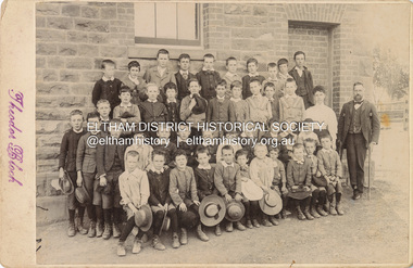
Photograph, Theodor Black, Boy students, Eltham State School No. 209, c.1904
Photo taken at the east end of the school. 1. Head Teacher John Brown served as HT from 1889 to his death in Sept 1906. 2. 53 Girls and 42 boys - 95 - attendance figures known between 1899 and 1906. 3. Female teacher in both photohraphs is Miss Amy E Barrowclough (Oct 1900 through 1904) [150th anniversary book incorrectly identifies her as Ellen Sweeney] 4. Youth in doorway is the Monitor, Harold Gilsenan (1904) 5. Post and rail fencing along Dalton Street (seen behind John Brown) was built in the upgrade of 1903 These facts date the photographs to be c.1904-c.1905 [Harry Gilham] Ina Falkiner is top row 4th from left Gertrude Falkiner is bottom row seated 4th from left. (Identified by Gertrude's garnddaugher and Ina's great neice, Judith Vun, email 26 May 2022) John Brown died 23 Sept 1906 after a short severe illness at age 55 and is buried in Box Hill Cemetery (Evelyn Observer 28 Sep 1906 p2). The book "We did open a school in Little Eltham" incorrectly states his date of death as 16/12/1906. Title The Evelyn Observer. (1906, September 28). Evelyn Observer and Bourke East Record (Vic. : 1902 - 1917), p. 2 (MORNING.) Url http://nla.gov.au/nla.news-article61129880 Description It is with sincere regret we record the death of Mr. John Brown, State school teacher, Eltham, which sad event took place at his residence, "Pine Brae," on Sunday night last, 23rd inst. after a severe illness of some few weeks' duration. The deceased gentleman was highly respected, and always took a lively and active interest in promoting the progress and prosperity of the district, and his loss will be much felt, He was only 55 years of age, and leaves a wife and large family to mourn their loss, and much sympathy is felt for them. The remains of the deceased were interred in the Box Hill cemetery on Wednesday afternoon last. PANEL 1875-1920 Panels began to be produced around 1875, and were particularly suited, because of their larger size, for capturing family, or even larger, groups. They measured 8.5 by 6.5 inches (22 cm x 16.5 cm). - Frost, Lenore; Dating Family Photos 1850-1920; Valiant Press Pty. Ltd., Berwick, Victoria 1991marg ball collection, shillinglaw family photo album 3, class photo, eltham primary school, eltham state school no. 209, 1904, harold gilsenan, john brown, miss amy e barrowclough, state school no. 209, theodor black photographer -
 Eltham District Historical Society Inc
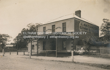
Photograph, Watson's Eltham Hotel on the Melbourne Road, Eltham, 1908
The Eltham Hotel was opened in 1854 situated on the south east corner of Main Road (Maria Street) and Pitt Street. Post card dated Eltham 2.1.1908 sent to Mr C. Watson "Malvale" Mardan Inscribed "Wishing you a Brigt and Happy New Year from Florrie" Most likley sent by Florence May Shillinglaw to sister Carrie Watson and new brother-in-law Christopher Watson - The Watsons married in 1907 View looking south on Main Road towards Pitt Street and Watson's Eltham Hotel on left. At this time, the hotel was run by Christopher Watson Jnr. Carrie Shillinglaw had recently married his son, Christopher. Ultimately the hotel would pass to his youngest son, Herbert James (Jim) Watson who demolished the original building in 1925 and erected a new modern building on the same site that remains in present time though modified several times over the years. See also EDHS_00133 POSTCARD 1905-1940s Like the carte-de-visite, postcards enjoyed a collecting craze by large numbers of people, and were often kept in albums through which the interested visitor could browse. Postcards were posted or exchanged in huge numbers. Postal authorities in Australia only allowed the private printing of postcards from 1898. At this time the back of the card was reserved for the address and postage stamp, and the front was used for the message and a picture. In 1902 British authorities allowed a "divided back", so that the left side could be used for the message, the right side for the address and stamp, and the whole of the front was devoted to the picture. France followed suit in 1904, Germany and Australia in 1905, and the United States in 1907. - Frost, Lenore; Dating Family Photos 1850-1920; Valiant Press Pty. Ltd., Berwick, Victoria 1991marg ball collection, postcard, eltham hotel, florence may bunker (nee shillinglaw) (1886-1969), main road, pitt street, caroline (carrie) watson (nee shillinglaw 1876-1956), christopher watson, 1908 -
 Eltham District Historical Society Inc
Photograph - Aerial Photograph, Landata, Eltham, Main Road; Henry St to Bellevue Rd, Dec. 1945
Eltham, Main Road; Henry St to Bellevue Rd, and east along Luck St to present day Eltham East School Historic Aerial Imagery Source: Landata.vic.gov.au Aerial Photo Details: Project No :5 Project : MELBOURNE AND METROPOLITAN AREA PROJECT Run : 36 Frame : 60549 Date : 12/1945 Film Type : B/W Camera : EAG4 Flying Height : 10200 Scale : 6000 Film Number : 228 GDA2020 : 37°42'45"S, 145°08'59"E MGA2020 : 336903, 5824465 (55) Melways : 21 K4 (ed. 42)aerial photo, arthur street, bellevue road, bible street, diamond street, dudley street, elsa court, eltham, eltham east primary school, gahan house, henry street, livingstone road, luck street, main road, pryor street, neil webster collection