Showing 1218 items matching "fishing"
-
 The Beechworth Burke Museum
Photograph, 1960s
This photograph was taken in the 1960s at Lake Sambell Caravan Park and visible in the photograph are individual caravan sites with electricity outlets, a large single-story building with a caravan park banner, dirt roads, a freestanding message board, and a parked car. Lake Sambell Caravan Park opened in 1959 owing to the work of R.E. Carter, Beechworth Shire engineer from 1954-63. Carter advocated for improvements to the lake and surrounding area in order to encourage tourism in Beechworth. The opening of the caravan park was part of many improvements to Lake Sambell made in this period by Carter including: the swimming pool in 1961, water skiing and boating facilities, and increased lake surface in 1964. These improvements were financed mainly by grants from the Tourist Development Authority. The popularity of caravanning in Australia exploded during this post-war period of the late 1950s and 1960s. This popularity was driven by multiple factors, including: the stopping of fuel rations, the accessibility of car ownership through the manufacturing of affordable cars, technological developments in caravan design, and the increase in prosperity and leisure time for many Australians. Facilities such as electrical outlets to power caravans are present in this photograph of Lake Sambell Caravan Park. Lake Sambell is an artificial lake that was developed on the previous site of the Rocky Mountain Mining Company workings and was officially opened by Minister for Lands, Mr Baily, on October 5, 1928. The disused and unattractive remains of the mine were converted into a recreational area intended for swimming, boating, and fishing. The lake is named after Mr L.H. Sambell, shire engineer and secretary of the Forward Beechworth Committee, who advocated for the enhancement of Beechworth into a tourist destination and was central to the planning and establishment of the lake. This photograph is of historical and social significance in providing insight into caravanning during the 1960s in Australia. Caravanning was extremely popular during the 1960s in Australia due to multiple social and economic factors including the stopping of fuel rations, the accessibility of car ownership through the manufacturing of affordable cars, technological developments in caravan design, and the increase in prosperity and leisure time for many Australians.Black and white rectangle photograph printed on photographic paper and unmounted.Reverse: 3536/ [logo back printing: KODAK/ VELOX/ PAPER] / C798 lake sambell caravan park, lake sambell, caravanning 1960s, caravan park, rocky mountain mining company, kodak velox paper, r.e. carter, l.h. sambell, caravan electricity outlets, tourist development authority, post-war prosperity, forward beechworth committee, lake sambell boating, lake sambell swimming pool, lake sambell fishing, artificial lake, travel 1960s, recreation 1960s -
 The Beechworth Burke Museum
Photograph, 1960s
This photograph was taken in the 1960s at Lake Sambell Caravan Park, visible in the photograph are individual caravan sites with electricity outlets, a large single-story building, a parked car, and two caravans partially obstructed by trees. Lake Sambell Caravan Park opened in 1959 owing to the work of R.E. Carter, Beechworth Shire engineer from 1954-63. Carter advocated for improvements to the lake and surrounding area in order to encourage tourism in Beechworth. The opening of the caravan park was part of many improvements to Lake Sambell made in this period by Carter including: the swimming pool in 1961, water skiing and boating facilities, and increased lake surface in 1964. These improvements were financed mainly by grants from the Tourist Development Authority. The popularity of caravanning in Australia exploded during this post-war period of the late 1950s and 1960s. This popularity was driven by multiple factors, including: the stopping of fuel rations, the accessibility of car ownership through the manufacturing of affordable cars, technological developments in caravan design, and the increase in prosperity and leisure time for many Australians. Facilities such as electrical outlets to power caravans are present in this photograph of Lake Sambell Caravan Park. Lake Sambell is an artificial lake that was developed on the previous site of the Rocky Mountain Mining Company workings and was officially opened by Minister for Lands, Mr Baily, on October 5, 1928. The disused and unattractive remains of the mine were converted into a recreational area intended for swimming, boating, and fishing. The lake is named after Mr L.H. Sambell, shire engineer and secretary of the Forward Beechworth Committee, who advocated for the enhancement of Beechworth into a tourist destination and was central to the planning and establishment of the lake. This photograph is of historic and social significance in documenting the enhancement of the Lake Sambell area overseen by R.E. Carter and providing insight into caravanning during the 1960s in Australia. Caravanning was extremely popular in Australia during the late 1950s and 60s due to multiple social and economic factors including the stopping of fuel rations, the accessibility of car ownership through the manufacturing of affordable cars, technological developments in caravan design, and the increase in prosperity and leisure time for many Australians. Black and white rectangle photograph printed on photographic paper and unmounted.Reverse: 3538/ [logo back printing KODAK/ VELOX/ PAPER] / C798lake sambell caravan park, lake sambell, lake sambell 1960s, lake sambell fishing, lake sambell boating, lake sambell swimming pool, r.e. carter, l.h. sambell, tourist development authority, caravanning 1960s, caravan electricity outlets, caravan park, forward beechworth committee, rocky mountain mining company, lake caravan park, caravan mid 20th century, beechworth tourism, travel in the 1960s, holiday 1960s -
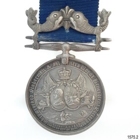 Flagstaff Hill Maritime Museum and Village
Award - Medal, Stokes, c 1882
This medal was presented by the Shipwrecked Fishermen and Mariners' Royal Benevolent Society and was posthumously awarded to Captain John Coffey’s family for his efforts at saving life at sea, in 1882. Captain Coffey lost his life in this attempt. The shipwreck occurred between Australia and England. The included letter was written by the donor, who is the grandson of John Coffey. It is interesting that the medal and note were packaged in a small tin whose original purpose was to present a wedding cake gift to guests. The container is decorated with wedding bells pressed into the lid. Shipwrecked Fishermen and Mariners’ Royal Benevolent Society: - The Shipwrecked Mariners (Shipwrecked Fishermen and Mariners’ Royal Benevolent Society) is a national charity established in 1839. It is run by a network of volunteers in the UK and Ireland. The organisation assists former mariners, their dependants and their families. John Rye and his servant Charles-Gee Jones, of Bath, UK, encouraged its formation after a severe storm caused the loss of life from the ‘Clovelly’ fishing fleet in November 1838. The Society was incorporated by an Act of Parliament in 1850. The Society’s flag is the St George’s Cross, a red cross on a white background and a gold crown in the centre, with the letters S F M S displayed, one in each quadrant. Nominations are made by members each year of those who have performed outstanding acts of bravery in helping those in peril in the sea. The inscription on the reverse "PRESENTED FOR HEROIC EXERTIONS IN SAVING LIFE FROM DROWNING / JOB XXIX 13" refers to a verse in the Bible, which in the King James version reads "The blessing of him that was ready to perish came upon me; and I caused the widow's eart to sing for joy."This is the only medal in our collection awarded from the Shipwrecked Fishermen and Mariners' Royal Benevolent Society. Medal, silver with blue ribbon. The obverse of the medal has images of the British flag, a crown flag with "S.F.", a portrait of a man, a shipwreck, a cannon and anchor, a man with a telescope, and two people attending a body on the shore. The reverse of the medal has text. The medal clasp depicts a fleur de lies between two fish. The medal maker is Stokes. The metal was donated in a tin container and included a letter. The medal was presented posthumously to the family of Captain John Coffey for his efforts at saving life at sea, in 1882. It has an accompanying letter and container.On rim "CAPTAIN JOHN COFFEY - 1882" Obverse "SHIPWRECKED FISHERMEN AND MARINERS ROYAL BENEVOLENT SOCIETY" and "ESTAB AD 1839 INCOd BY ACT OF PARLt 1850" Reverse "PRESENTED FOR HEROIC EXERTIONS IN SAVING LIFE FROM DROWNING / JOB XXIX 13" and "ENGLAND EXPECTS EVERY MAN WILL DO HIS DUTY" The tin box has "MEDAL" handwritten in black.flagstaff hill, flagstaff hill maritime museum and village, warrnambool, maritime museum, maritime village, great ocean road, shipwreck coast, medal, captain john coffey, john coffey, numismatics, hero, saving lives, shipwrecked fishermen and mariners’ royal benevolent society, sfms, shipwrecked mariners' society -
 Orbost & District Historical Society
black and white photograph, late 19th century / early 20th century
The first settler to occupy the Marlo township area was James Stirling around the year 1875. He built a bark hut on the bluff that had two rooms, bark walls, earthen floors and a shingle roof. By 1884, this structure had expanded to a 9 roomed accommodation house and in 1886 became the Marlo Hotel when a liquor license was granted. The Governor-in-Council declared Marlo to be a township on 18 February 1889. During May 1889, the government surveyor, E.L. Bruce set out 19 sections of the new township, with the first sales of subdivided land occurring the following May. At this time, Stirling's Marlo Hotel was the unofficial hub for the community. It was a general store, accommodation house and the unofficial post office, with settlers taking turns in bringing the mail from Orbost or Cunningham. This continued until Aug 1942, and in 1969 was located in a house adjacent to the Marlo Hotel, before being transferred to the Marlo General Store in this year. The official Post Office List states the Marlo Post Office opened around 1902. in 1925, the "Marlo House" (a nine room accommodation guest house) was granted a liquor licence. The "Marlo House" became "The Marlo Hotel". The Marlo Hotel was popular with many Orbost and district settlers, who travelled to Marlo by horseback or buggy. In the early 20th century the hotel advertised itself as " Under Vice-Regal Patronage. Situated on High Cliff, fronting Ocean, Lakes and Snowy River. Those in search of Health, Rest and Sport should visit Marlo. Boating, Fishing, Shooting, Bathing, Golf. Comfort and Convenience at Marlo Hotel, near Orbost, East Gippsland. Nixon's Cars would meet the train at at Orbost. Fare---6s single, 12s return. Telephone No. 1, Marlo. S, P, STEWART, Proprietor." The Marlo Hotel, perched on the hill overlooking the estuaries and the entrance is a significant building in Marlo. Established in 1886, it has been operating for over 120 yearsAn original black / white photograph and a black / white copy of a party being held under trees on the lawn of the Marlo Hotel. It is a postcard with advertising of Marlo on the back.on back - "Where to spend your holiday - Marlo" on front - "Vice Regal Party at Hotel, Marlo"marlo-hotel -
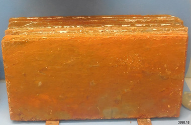
 Flagstaff Hill Maritime Museum and Village
Geological specimen - Slate, c. 1908
These rectangular slates of 'beautiful, unusual, expensive, green' American roof tiles were recovered from the wreck of the Falls of Halladale. Salvaging began in 1974 by volunteer divers, using local cray-fishing boats. An efficient system was devised to recover up to 4,000 of the still neatly packed slates a day. Many of the 22,000 salvaged slates can be seen on the roofs of eight buildings in the Flagstaff Hill Maritime Village. The iron-hulled, four-masted barque, the Falls of Halladale (1886 - 1908), was a bulk carrier of general cargo. She left New York in August 1908 on her way to Melbourne and Sydney. In her hold, along with 56,763 tiles of unusual beautiful green American slates (roof tiles), 5,673 coils of barbed wire, 600 stoves, 500 sewing machines, 6500 gallons of oil, 14400 gallons of benzene, and many other manufactured items, were 117 cases of crockery and glassware. Three months later and close to her destination, a navigational error caused the Falls of Halladale to be wrecked on a reef off the Peterborough headland at 3 am on the morning of the 15th of November, 1908. The captain and 29 crew members all survived, but her valuable cargo was largely lost, despite two salvage attempts in 1908-09 and 1910. The ship stayed in full sail on the rocky shelf for nearly two months, attracting hundreds of sightseers who watched her slowly disintegrate until the pounding seas and dynamiting by salvagers finally broke her back, and her remains disappeared back into deeper water. The shipwreck is a popular site for divers, about 300m offshore and in 3 – 15m of water. Some of the original cargo can be seen at the site, including pieces of roof slate and coils of barbed wire.The Falls of Halladale shipwreck is listed on the Victorian Heritage Register (No. S255). She was one of the last ships to sail the Trade Routes. She is one of the first vessels to have fore and aft lifting bridges. She is an example of the remains of an International Cargo Ship and also represents aspects of Victoria’s shipping industry The wreck is protected as a Historic Shipwreck under the Commonwealth Historic Shipwrecks Act (1976).Rectangular slates of green American roof tiles, some with a red-brown stain. These are a sample of hundreds of slate roof tiles salvaged from the vessel FALLS of HALLADALENoneflagstaff hill, warrnambool, maritime museum, maritime village, great ocean road, shipwreck coast, cargo, slate, slate tile, green american slates, building material, wreck point, peterborough, bay of islands, russell & co., 1908 shipwreck, salvage, recover -
 Flagstaff Hill Maritime Museum and Village
Geological specimen - Slate Roof Tiles
These rectangular slates of 'beautiful, unusual, expensive, green' American roof tiles were recovered from the wreck of the Falls of Halladale. Salvaging began in 1974 by volunteer divers, using local cray-fishing boats. An efficient system was devised to recover up to 4,000 of the still neatly packed slates a day. Many of the 22,000 salvaged slates can be seen on the roofs of eight Flagstaff Hill Maritime Village buildings. The iron-hulled, four-masted barque, the Falls of Halladale (1886 - 1908), was a bulk carrier of general cargo. She left New York in August 1908 on her way to Melbourne and Sydney. In her hold, along with 56,763 tiles of unusual beautiful green American slates (roof tiles), 5,673 coils of barbed wire, 600 stoves, 500 sewing machines, 6500 gallons of oil, 14400 gallons of benzene, and many other manufactured items, were 117 cases of crockery and glassware. Three months later and close to her destination, a navigational error caused the Falls of Halladale to be wrecked, grounded on a reef at Wreck Point, midway between Peterborough and the Bay of Islands, during the night of 14th November 1908. The captain and 29 crew members all survived, but her valuable cargo was largely lost, despite two salvage attempts in 1908-09 and 1910. The ship stayed in full sail on the rocky shelf for nearly two months, attracting hundreds of sightseers who watched her slowly disintegrate until the pounding seas and dynamiting by salvagers finally broke her back, and her remains disappeared back into deeper water. The shipwreck is a popular site for divers, about 300m offshore and in 3 – 15m of water. Some of the original cargo can be seen at the site, including pieces of roof slate and coils of barbed wire.The American slate tiles are significant as an example of cargo imported for use as building materials in Australia. The Falls of Halladale shipwreck is listed on the Victorian Heritage Register (No. S255). She was one of the last ships to sail the Trade Routes. She is one of the first vessels to have fore and aft lifting bridges. She is an example of the remains of an International Cargo Ship and also represents aspects of Victoria’s shipping industry The wreck is protected as a Historic Shipwreck under the Commonwealth Historic Shipwrecks Act (1976).Bundle of slate roof tiles (18); rectangular, green American slate roof tiles, some with red-brown stains. Two tiles both have two holes drilled through them. Two different tiles are thicker than the others. The tiles were salvaged from the wreck of Falls of Halladale. flagstaff hill, warrnambool, maritime village, maritime museum, shipwreck coast, great ocean road, cargo, slate, slate tile, green american slates, building material, wreck point, peterborough, bay of islands, russell & co., 1908 shipwreck, salvage, recover -
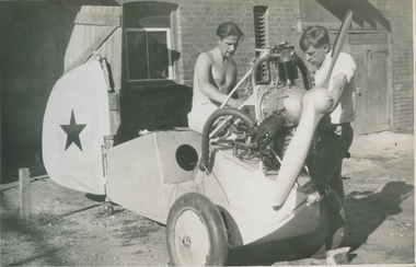 Bendigo Historical Society Inc.
Photograph - Gliding in Bendigo, Late 1930s
These are the recollections of Alan Menere (1915 – 2001). Alan grew up in Moonee Ponds, Victoria, and moved to Bendigo while in his early 20s. There he met some like-minded young men who enjoyed challenges and matters mechanical. Flying was the adventure of the time, and they decided to give it a go. There was no intention to be on the leading edge of gliding technology. The challenge was to fly, and by their own efforts. They were aided in this by the embryonic regulatory arrangements covering light aircraft construction and flying, a sense of optimistic can-do, and the cavalier estimation of risks that goes with being in your early 20s. The events described here took place against a darkening political background. Alan and his mates were politically aware, very left wing, and viewed the gathering storm in Europe with apprehension. They could see from early on that war was coming, and it would change everything. Prevented from joining the Air Force by his red-green colour blindness, Alan joined the Army the day after the Pearl Harbour attack. He served in an Armoured Reconnaissance Unit in Western Australia, then with the Army Education Service in New Britain. After the War he joined the Commonwealth Public Service. He moved to Canberra, but his Bendigo habits stayed with him, as he built sailboards and carved propellers, to the admiration of his sons. Alan developed macular degeneration in his mid-60s. He retired to Port Stephens, fishing and socializing when he wasn’t tinkering with wing-sails for his catamaran. As he could touch-type, he quickly learned to use a computer. Very aware that he was the last member of the Bendigo group still alive, he resolved to set down his flying experiences. The images he selected are included, but there are many more from the Bendigo days.A CD entitled "Alan Menere - Recollections of Gliding in Bendigo in the late 1930s". The CD contains 33 documents consisting of one word file, one PDF file (entitled "The Urge to Fly") and the rest are of either photos of the Bendigo Gliding club or generally around Bendigo itself. Also included are some paper clippings of accidents that happened and description of flights.history, bendigo, bendigo gliding club, alan menere -
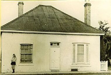 Wodonga & District Historical Society Inc
Photograph - Stonleigh, Wodonga
Stonleigh is one of Wodonga’s earliest buildings and stands on land granted to Daniel Rhodes in 1854, in one of the first land sales conducted in Wodonga. The building commenced soon after with the stone walls being 18 inches (46cm) thick. It was a four-room granite rubble stone building with central door and a window on either side, with a separate kitchen, as was typical of the worker's cottage of the day. The original roof would have been shingles but it was replaced with corrugated iron. It passed through several owners including Paul Huon in 1858. Peter Tenner, a farmer and vigneron took over in 1866 when it was described as “built of stone and having a cellar and a detached kitchen plus outside toilet, and a shed or two.” In the late 1880’s it was owned by William Smith who had come to Wodonga as a missionary for the Presbyterian Church and who, together with John Whan, storekeeper, was instrumental in building the Presbyterian Church nearby. Between 1890 and 1910 further buildings were added, consisting of double brick walls, two bedrooms, kitchen, laundry with brick and copper, bathroom and side verandah. William Smith established Wodonga Cordage Works in the Stonleigh buildings. The front room of the house was the display room for the business which manufactured and sold fishing lines, various types of cordage and water bags, the latter being of hand-sewn canvas. After 1954 Stonleigh became a bottle depot and bottle museum under ownership of Ramon Porta. At one stage he had over 50,000 bottles on display. In 1991 it was purchased by Mark Fraser, a cabinet maker, who made extensive renovations at the rear of the premises and internally, but left the façade untouched. Over recent times, Stonleigh was the home of several business including a florist, a patchwork maker and a café. Stonleigh was sold in 2021 and is now a private residence.These images capture one of Wodonga's oldest buildings.A series of photos, both colour and black and white, showing the building "Stonleigh' at different periodsstonleigh wodonga, old buildings wodonga, wodonga businesses, wodonga pioneers -
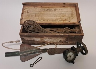 Glenelg Shire Council Cultural Collection
Functional object - Walker's 'Excelsior' Yacht Log Mark II, Thomas Walker, c. 1900
From Scarborough Maritime Heritage Centre: A Yacht Log was a nautical instrument for measuring a vessel's speed and distance travelled. When navigating a ship it is essential to be able to estimate the boat's speed and distance travelled to determine its position at sea. In times past the only way to measure a ship's speed was to throw a wood log into the water and observe how fast it moved away from the ship. In the 16th century, the log was fastened to a rope knotted at set intervals. The log was thrown over the stern (back) of the vessel and a crew member counted the number of knots that were paid out in a set time. From this they could estimate the speed of the vessel through the water. This was known as streaming the log and is also the derivation of the knot as a measurement of nautical speed. In 1878, Thomas Ferdinand Walker (1837–1921), an engineer in Birmingham, patented a mechanical log in which a recording instrument was attached to a rail at the stern of a vessel connected by a long cord with a rotor which was towed behind the ship. The instrument dial recorded the distance travelled. The 'Log' at the Heritage Centre was recovered from a skip in Scarborough and was one of the first artefacts collected by the volunteer group. It is made of brass with a ceramic dial, with the main scale marked from 0 to 100 nautical miles and an inset dial marked from 0 to 10 miles. It has a fixing plate, on which it can turn, with which it would have been attached to the 'taffrail', the rail at the stern of a ship, usually on the starboard side. The Walker’s Excelsior Mark IV instrument was designed for smaller vessels, such as yachts, launches and fishing vessels. Its exact date of manufacture cannot be determined but this design was manufactured in the first half of the 20th century. These mechanical logs have now been superseded by electronic equipment such as GPS navigation instruments.This instrument was made by a significant nautical instrument manufacturer and demonstrates the innovation needed at the time for improved navigation and safety at sea.Timber Box containing an instrument for measuring speed and distance. There is a brass, cased log with a white enamel dial. It also includes a towing cord and cylindrical rotator. The box has paper labelling on the front and also the inside of the lid. The label on the inside of the lid has instructions for use. Although the lid is hinged it has broken off and is separate. The hinges remain attached.Enamel Dial: Walkers Patent Excelsior Yacht Logmaritime, maritime history, tool, navigational tool, navigational instrument, navigation, sailing, walkers, maritime technology, walker & son -
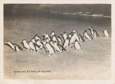 Phillip Island and District Historical Society Inc.
Photographs, 1940's
12 photographs from a collection of 33 donated by Leonie Brennan. Photographs belonged to Edward (Ted) Sands, hairdresser.Photograph 215-22. Penguins coming home after a day of fishing at the nightly parade Summerland Beach. Photograph 215-23. Pyramid Rock, Phillip Island. Photograph 215-24. Cowes beach with a large group of people gathered together and others under beach umbrellas. Beach west side of the Cowes Pier. Photograph 215-25. Large group of Seals at Seal Rocks, Phillip Island. Photograph 215-26. The Killara Ferry at Cowes pier with chimney smoking. Photograph 215-27. The Pinnacles at Cape Woolamai, Phillip Island. Photograph 215-28. Looking towards the Isle of Wight Hotel at Cowes and the Jetty Shed at the end of the Cowes Pier. Photograph 215-29. The Cowes Pier with the Killara Ferry docked. Photograph 215-30. The Killara Ferry heavily laden with passengers. A close-up showing the back entrance for vehicles. Photograph 215-31. The War Memorial at Cowes looking towards the pier. Shows the pier and the Jetty Shed on the pier. Photograph 215-32. View from inside Forrest Caves, Phillip Island, with two people standing in front. Photograph 215-33. The Nobbies, Phillip Island, with waves crashing onto the rocks.215-22 "Penguins at Phillip Island" 215-23 "Pyramid Rock, Phillip Island" 215-24 "The Beach, Cowes" 215-25 "Seals at Cowes, Phillip Island" 215-26 "The Killara at Cowes" 215-27 "Cape Woolamai, Phillip Island" 215-28 "The Pier, Cowes" 215-29 "The Pier, Cowes" 215-30 "The Killara at Cowes" 215-31 "War Memorial, Cowes" 215-32 "Forest Caves, Phillip Island" 215-33 "Rough seas at The Nobbies, Cowes"penguins coming ashore, penguins, wildlife - penguins, pyramid rock, phillip island, pyramid rock, coastline - rock formation - pyramid rock, cowes beach, phillip island, seals on seal rocks phillip island, wildlife - seals, the killara ferry, killara ferry, the pinnacles, the pinnacles cape woolamai, the pinnacles, phillip island, the isle of wight hotel cowes phillip island, cowes pier, phillip island, cowes jetty, phillip island, war memorial, cowes, phillip island, forrest caves, phillip island, the nobbies, phillip island, mr edward (ted) sands, leonie brennan -
 Bendigo Historical Society Inc.
Document - PETER ELLIS COLLECTION: PETER ELLIS FUNERAL PROGRAM, 27th March, 1946
Peter Ellis funeral program. Peter Nicolaus Ellis. 27th March 1946 - 18th May 2015. Service for thanksgiving. Mulqueen Family Chapel Bendigo. Monday 25th May 2015. Celebrant: Mr Ian Hendry. Coffin Bearers Brian Edelbohle, John Cockfield, Doug Colt, Rick Bambridge, Ryan Hearps, Garry Lovejoy. Entrance Music: Live from The Emu Creek Bush Band. Welcome. Condolences. Celebrant's comments. Tributes: Brian Edelbohle, John Williams, Rob Willis, Rob Moors, Ryan Hearps. A time of reflection. Announcements. Celebrant's comments. Committal. Recessional Music: Live from The Emu Creek Band. You are invited to join Peter's family and friends for light refreshments at the One Tree Hill Hotel from about 12.30 this afternoon. Peter's family and extended family sincerely thank you for your attendance here today and for your love and support during this difficult time. Thank you. Leave memorial messages at www.heavenaddress.com @heaven address. Mulqueen family funeral directors Bridge street, Bendigo 03 5443 4455. Copyright Agency Limited Licensed Copy. Photo of Peter Ellis on front. Boy with dog fishing inside left. Photo of Peter Family and another of Mulqueen Funeral Home.person, individual, peter ellis oam -
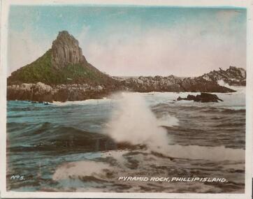 Phillip Island and District Historical Society Inc.
Photographs, 1940's
A selection of photographs sold to tourists. A selection of hand coloured photographs of Phillip Island. Following description as on the photographs. 344-01: Pyramid Rock, Phillip Island. No. 5. 344-02: Penguin Beach, Summerlands, Phillip Island No. 3. 344-03: The 'Killara' at the pier, Cowes. No. 10 (shows Cowes Pier with shed and Killara Ferry.) 344-04: Boat arriving at Cowes. No. 9. (shows the Killara near the pier full of people.) 344-05: The beach, Cowes No. 8. (beachgoers on the Cowes west beach enjoying the sun - many sitting under beach umbrellas.) 344-06: The Nobbies showing Seal Rocks, Phillip Island. No. 4. (Coastal scene at The Nobbies with Seal Rocks in the distance.) 344-07: Penguins, Phillip Island No. 11. (Penguins arriving on the beach at dusk after a day out fishing.) 344-08: Rocks at Cape Woolamai, Phillip Island. No. 7. 344-09: The Pier, Cowes. No. 1. (Photo taken from the end of the Cowes Pier looking towards Cowes Township. Jetty shed and Isle of Wight Hotel in the background.) 344-10: The Pier & War Memorial, Cowes. No. 12. (Taken looking from The Esplanade to the War Memorial and Cowes Pier. People and boats at the Pier.) 344-11: Seals at Phillip Island. No. 6. (Seals are on Seal Rocks out from The Nobbies.)As above.pyramid rock, summerland beach, the killara ferry, cowes pier phillip island, cowes beach phillip island, the nobbies, penguins, wildlife - penguins, cape woolamai phillip island, cowes war memorial, seals on seal rocks phillip island, wildlife - seals, cheryl burton -
 Clunes Museum
Photograph - PHOTOGRAPHS OF EVENTS
.1-.23 PHOTOGRAPHS OF THE GOLD FESTIVAL: .1 CDAS FLOAT .2 A PALOMINO WITH RIDER IN FRONT OF THE OLD LIBRARY .3 PEOPLE IN COSTUMES FROM THE GOLD MINING TIME .4 FLOAT FROM THE ANGLING CLUB ON A TRAILER WITH SHRUBS, 2 MEN, "GONE FISHING" ON THE SIDE .5 FLOAT : A TRAILER WITH PEOPLE IN COSTUMES .6 CLUNES PRIMARY SCHOOL PUPILS MARCHING IN COSTUMES .7 M FAWCETT ON A MECHANICAL HORSE .8 BARB ADAM WITH THE HOSPITAL FLOAT .9 CLUNES DISTRICT HEALTH SERVICE FLOAT .10 WHEEL BARROW RACE .11 HEALTH SERVICE FLOAT .12 PREPARING HEALTH SERVICE FLOAT .13 CLUNES LIONS CLUB FLOAT .14 A UTE WITH PEOPLE AND FRUIT FLOAT .15 MT CAMERON FIRE TRUCK .16 CLUNES GARDEN CLUB MARCHING WITH FLOWERS AND WHEEL BARROWS .17 MEMBERS OF THE BOWLING CLUB ON A TRUCK .18 CDAS FLOAT .19 M FAWCETT ON A MECHANICAL HORSE .20 PEOPLE IN FRASER STREET AT THE GOLD FESTIVAL .21 MARCHING FIRE BRIGADE .22 PEOPLE LINING FRASER STREET, WAITING FOR THE PARADE .23 CLUNES DISTRICT AGRICULTURAL SOCIETY FLOAT .24 PHOTOGRAPH OF VINTAGE CAR RALLY 2/2001 .25 MINERS WALK TO CLUNES .26 A GROUP OF PEOPLE SOCIALISING .27 PHOTOGRAPH OF PEOPLE AT "BACK TO CLUNES EASTER 1982" .25 WRITTEN ON BACK: JUDITH FAWCETT (BACK), ALISON HULL, JOSIE SEERS, JO BIDWELLgold festival, back to clunes 1982, miners walk, vintage car rally -
 Bendigo Historical Society Inc.
Map - Laminated map of Lake Eppalock at full capacity. Map 'E'
John Perry Collection. Laminated map of Lake Eppalock at full capacity. Black and white. The dam was built by the State Rivers and Water Supply Commission of Victoria. The dam wall height is 45 metres (148 ft) and the main embankment is 1,041 metres (3,415 ft) long. At 100% capacity the dam wall was designed to hold back 304,651 megalitres (6.7014×10¹⁰ imp gal; 8.0480×10¹⁰ US gal) of water. The surface area of Lake Eppalock is 3,011 hectares (7,440 acres) and the catchment area is 2,124 square kilometres (820 sq mi). The controlled spillway is capable of discharging 8,040 cubic metres per second (284,000 cu ft/s). Lake Eppalock supplies both stock and domestic water to the Campaspe irrigation district. It also serves as a water supply to Bendigo and Heathcote and, in more recent times, Ballarat. The lake is a major attraction for those engaging in watersports, with a number of tourist parks and accommodation facilities available. Permissible activities on the lake include high-speed boating, water skiing, sailing, canoeing, fishing and swimming. The lake's water levels were low for approximately eight years between 2002 and 2010 during a prolonged drought, which restricted the amount of recreational activity until rainfall in the latter half of 2010 returned the lake to 100 percent capacity. Built between 1961 and 1964, Lake Eppalock remains the only water storage on the Campaspe River system.map, eppalock, water, dam, reservoir -
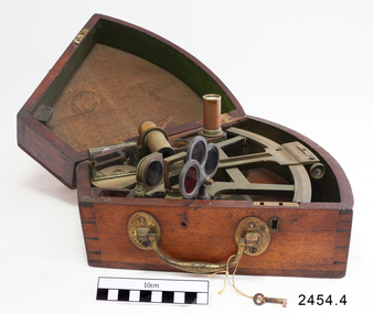 Flagstaff Hill Maritime Museum and Village
Octant, Mid to late 19th Century
An octant is an astronomical instrument used in measuring the angles of heavenly bodies such as the sun, moon and stars at sea in relation to the horizon. This measurement could then be used to calculate the altitude of the body measured, and then the latitude at sea could also be calculated. The angle of the arms of an octant is 45 degrees, or 1/8 of a circle, which gives the instrument its name. Two men independently developed the octant around 1730: John Hadley (1682–1744), an English mathematician, and Thomas Godfrey (1704–1749), a glazier in Philadelphia. While both have a legitimate and equal claim to the invention, Hadley generally gets the greater share of the credit. This reflects the central role that London and the Royal Society played in the history of scientific instruments in the eighteenth and nineteenth century's. There were also two others who are attributed to having created octanes during this period, Caleb Smith, an English insurance broker with a strong interest in astronomy (in 1734), and Jean-Paul Fouchy, a mathematics professor and astronomer in France (in 1732) In 1767 the first edition of the Nautical Almanac tabulated lunar distances, enabling navigators to find the current time from the angle between the sun and the moon. This angle is sometimes larger than 90°, and thus not possible to measure with an octant. For that reason, Admiral John Campbell, who conducted shipboard experiments with the lunar distance method, suggested a larger instrument and the sextant was developed. From that time onward, the sextant was the instrument that experienced significant development and improvements and was the instrument of choice for naval navigators. The octant continued to be produced well into the 19th century, though it was generally a less accurate and less expensive instrument. The lower price of the octant, including versions without a telescope, made it a practical instrument for ships in the merchant and fishing fleets. One common practice among navigators up to the late nineteenth century was to use both a sextant and an octant. The sextant was used with great care and only for lunar sightings while the octant was used for routine meridional altitude measurements of the sun every day. This protected the very accurate and pricier sextant while using the more affordable octant for general use where it performs well. The invention of the octant was a significant step in providing accuracy of a sailors latitude position at sea and his vessels distance from land when taking sightings of land-based landmarks.Octant with metal handle, three different colored shades are attached, in wooden wedge-shaped box lined with green felt. Key is attached. Two telescope eyepieces are in box. Some parts are missing. Oval ink stamp inside lid of box, scale is graduated to 45 degrees. Ink stamp inside lid of box "SHIPLOVERS SOCIETY OF VICTORIA. LIBRARY"instrument, flagstaff hill, warrnambool, shipwrecked coast, flagstaff hill maritime museum, maritime museum, shipwreck coast, flagstaff hill maritime village, great ocean road, octant, navigation, nautical instrument, navigation instrument, john hadley, sextant, astronomical instrument -
 Flagstaff Hill Maritime Museum and Village
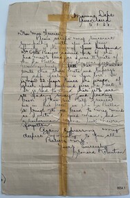
Letter - Ferrier Letter, Leonard Robertson, Marine Department, 5 January 1938
This letter of sympathy is written to the widow of William Ferrier who rescued Captain Mylius and another seaman from the shipwreck, La Bella, at Warrnambool. Leonard Robertson, from Auckland, was II Mate of the La Bella. The letter was written from the Marine Dept. Queensland. Many newspaper accounts narrate the rescue and evidence given at the Marine Court of Inquiry. A book "Leonard Robertson, the Whangaroa & La Bella"/Jack Churchouse was printed. William Ferrier was born in Warrnambool and it is reported that he was a member of the lifeboat crew and served some years in the lighthouse service. During the La Bella rescue Ferrier used his dinghy, as he was an experienced fisherman of 25 years old. Ferrier, moved to Queenscliff at some stage and died at the Geelong hospital after having a seizure at sea. Ferrier's 15 years old son was having his birthday and fishing with him at the time. He was survived by his widow and 13 children. Otto Bayer who had informed Robertson of Ferrier's death was a crew member of the lifeboat. The site of the La Bella wreck lies in Lady Bay Warrnambool, at La Bella Reef - named after the fact. Transcript: Marine Dept Queensland 5.1.38 Dear Mrs Ferrier, Please accept my Sincerest Sympathy with you and your family in the loss of your husband. Mr. Otto Bayer advised me of the sad news and as I was II Mate of the La Bella when she was lost at Warrnambool I feel that I should write this short note and express my deep feelings in your loss. It is now 32 years since the wreck of which your husband was the hero. It is sad to think that we are all fading away and looking back I can see Bill Ferrier out in his boat at the La Bella it brings it all back to my mind as I write. A good man, and sailorman, is gone but never forgotten. Again expressing my deepest sympathy to you all Believe me, Yours Sincerely Leonard Robertson.This item is of historical significance in relation to the La Bella shipwreck as it is written and signed by a survivor and witness of the rescue. It is a single letter to the wife of the hero William 'Bill' Ferrier. The Ferrier family have a long social history with Warrnambool and Ferrier Drive is named in honour of the hero. The letter front is written on a lined and yellowed paper that has been repaired. The repair runs from top to bottom and has been done with cello tape. A small repair runs across the middle a couple of centimetres from the top and for approximately four centimetres down the middle. There are some small tears to the edges, particularly on fold creases. There are small brown age spots to peripheral areas. This is a sympathy letter from Leonard Robertson, II Mate and survivor of the La Bella to the widow of William (Bill) Ferrier rescue hero on his death. Inscribed in blue ink: "OWNER. G. FERRIER / LOANED. TO. BE / PHOTOGRAPHED / 27/4/76"flagstaff hill maritime museum and village, great ocean road, shipwreck coast, la bella, william ferrier, bill ferrier, lady bay, 1905, 10th november 1905, 11th november 1905, parliament of the commonwealth, prime minister, australian government, new zealand, flagstaff hill, warrnambool, shipwrecked coast, flagstaff hill maritime museum, maritime museum, flagstaff hill maritime village, leonard robertson, rescue, frank ferrier, la bella reef, otto bayer -
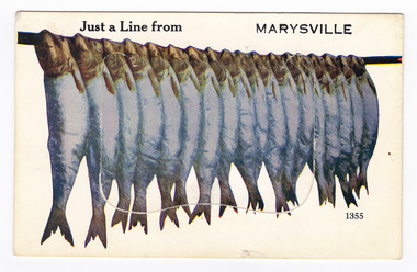 Marysville & District Historical Society
Postcard (item) - Novelty postcard, Valentine Publishing Co. Pty. Ltd, Just a Line from MARYSVILLE, 1940's-1960's
A novelty postcard with pull-out strip of 9 miniature photographs that was produced by the Valentine Publishing Co as a souvenir of Marysville.A novelty postcard with pull-out strip of 9 miniature photographs that was produced by the Valentine Publishing Co as a souvenir of Marysville.Just a Line from MARYSVILLE 1355 PRINTED PAPER/ MAILING NOVELTY TO OPEN RAISE FLAP VALENTINE'S "MAIL NOVELTY" POST CARD/ COPYRIGHT From Printed in Great Britain To Marysville Chalet/ Marysville/ Phone 12 Dear Nev. We had a good/ trip up, left Ballarat/ 1/4 to 2 & Ivy & Kev were waiting 1/2 hr for us &/ Kev took the lead through Melbourne & by cripes/ was I glad to get through it, our darn engine/ kept cutting out, at the stop signs, by cripes I felt/ like crawling under the seat. Its beautiful weather/ here, we done a couple of good walks, going fishing/ this afternoon, Merle & Valerie have mixed up with/ some of the young mob & seem to be doing alright./ Well hope every-thing is going OK down there./ Merle & Val are thinking of going horse riding./ The trees and ferns are gorgeous here, tall I have never/ seen so tall a trees. Well Nev must close now. Love from Mum. Xmarysville, victoria, postcard, souvenie, valentine publishing co, crossways cabaret (image 1), taggerty river (image 2), acheron way (image 3), black spur (image 4), nicholl's lookout (image 5), main street marysville (image 6), sugarloaf bay eildon (image 7), steavenson falls (image 8), cumberland falls (image 9) -
Glenelg Shire Council Cultural Collection
Photograph - Photograph - Portland Lifeboat, n.d
Built in 1858 at the Port and Harbour Master's yard in Williamstown Victoria, the Portland Lifeboat was overseen by Harbour Master Charles Ferguson. It is understood to have been constructed from the same moulds used to build the Port Fairy Lifeboat, designed by William White, in 1857. Both boats are similar to the lifeboats designed in England by James Peake and adopted by the Royal National Lifeboat Institution (RNLI) in the UK. The Portland Lifeboat's 9.14 m (30 ft) long hull is double diagonally planked in New Zealand kauri, and many of the planks run from gunwale to gunwale in one piece under the inner keel section. Eucalyptus and oregon were used elsewhere and the local blacksmith made the iron work. The fastenings are copper. There are two flotation or buoyancy tanks at either end, with prominent whaleback style decking. Under the thwarts is a deck with scuppers so that the craft is both buoyant and self draining whenever large waves are taken aboard in rough conditions. The lifeboat was oar-powered with a sailing rig. The original rig was a lug mainsail, but this was replaced with a lug and headsail rig taken from a fishing boat in 1903. The lifeboat was manned by volunteer crews, mostly local fishermen from Portland. They maintained this service until 1915 when the boat was replaced with a new motorised craft. The lifeboat's most outstanding service was to the steamer ADMELLA in 1859 when the ship grounded on a reef off Cape Banks in South Australia, 150 km to the west of Portland. Survivors clung to the rigging in heavy seas for over a week and 89 people lost their lives in the shipwreck. Taken to the scene by the steamer LADY BIRD, the Portland Lifeboat was unable to assist until eight days after the ADMELLA's grounding when the seas abated enough for the lifeboat to manoeuvre close to the ship and rescue the last 19 survivors. Since its retirement in 1915 the lifeboat has been a memorial to those who manned it and those it rescued. For a long period it was on display in the Portland Gardens, first in the open and then under a canopy. In 2008 it was on display inside the Portland Maritime Discovery Centre, still in original condition complete with the rig from 1915. It is one of the oldest vessels of its type in Australia, and the world.Portland LifeboatPhotograph showing the Portland Lifeboatphotography, portland lifeboat, admella -
Unions Ballarat
Our inheritance: Speeches and addresses (Don Woodward Collection), Baldwin, Stanley, 1928
A selection of speeches and addresses on social, political and other topics. Contents (copied from the Victorian State Library website): Harrow School War Memorial: Address delivered at the unveiling ceremony at Harrow, 3rd June 1926 -- Freedom: Speech delivered at Kingsway Hall at the 30th anniversary of the Junior Imperial League, 19th June 1926 -- The British Merchant Service: Speech delivered at the dinner of the Chamber of Shipping of the United Kingdom, 16th February 1927 -- Westminster Abbey: Appeal for funds, 1st July 1927 -- Democracy and its task: Speech delivered at the dinner of the Cambridge University Conservative Association, 4th March 1927 -- Scotland: Address delivered on the occasion of receiving the Freedom of Edinburgh, 7th June 1926 -- The romance of Edinburgh: Speech delivered at the luncheon given on the occasion of receiving the Freedom of Edinburgh, 7th June 1926 -- Wales: Speech delivered at the St. David's Day Banquet at Cardiff, 1st March 1927 -- The Earl of Oxford and Asquith: Speech delivered in the House of Commons, 16th February 1928 -- Earl Haig of Bemersyde: Speech delivered in the House of Commons, 8th February 1928 -- Among sculptors: Speech delivered at the Dinner of the Royal Society of British Sculptors, 25th February 1926 -- Among historians: Address of welcome delivered to the members of the Anglo-American Conference of Historians, 13th July 1926 -- Among archaeologists: Speech delivered at the Annual Meeting of the British School at Athens, in London, 2nd November 1926 -- Among doctors: Speech delivered at the annual dinner of the Royal Society of Medicine, 18th November 1926 -- Lister: Speech delivered on the occasion of the Lister Centenary Celebrations, 5th April 1927 -- Among scientists: Speech delivered at the dinner of the Royal Society, 30th November 1947 -- Worcestershire: Speech delivered at the inaugural banquet of the Worcestershire Association, 22nd February 1927 -- Books: Speech delivered at the dinner of the English Association, 28th October 1927 -- Cricket: Speech delivered at the luncheon given to the Australian Cricket Team, 20th April 1926 -- Lord's: The Eton and Harrow match: Introduction to Sir Home Gordon's book, "Eton v. Harrow at Lord's" -- Fly fishing : Speech delivered at the annual dinner of the Fly Fishers' Club, 24th February 1927 -- The loneliest job: Speech delivered at Worcester, 8th January 1927.Historical, political and social - United Kingdom.Book; 309 pages. Cover: blue background; white lettering; author's name and title.In black ink: To dear papa with love Doreen. Christmas 1929.politics and government, social commentary, art and history, sporting life, btlc, ballarat trades hall, ballarat trades and labour council, political speeches, speeches - various -
 Bendigo Historical Society Inc.
Map - Laminated map of Lake Eppalock at full capacity
John Perry Collection. Laminated copy of map of Lake Eppalock at full capacity. Had highlighter markings of old roads which appear to be still in use. The dam was built by the State Rivers and Water Supply Commission of Victoria. The dam wall height is 45 metres (148 ft) and the main embankment is 1,041 metres (3,415 ft) long. At 100% capacity the dam wall was designed to hold back 304,651 megalitres (6.7014×10¹⁰ imp gal; 8.0480×10¹⁰ US gal) of water. The surface area of Lake Eppalock is 3,011 hectares (7,440 acres) and the catchment area is 2,124 square kilometres (820 sq mi). The controlled spillway is capable of discharging 8,040 cubic metres per second (284,000 cu ft/s). Lake Eppalock supplies both stock and domestic water to the Campaspe irrigation district. It also serves as a water supply to Bendigo and Heathcote and, in more recent times, Ballarat. The lake is a major attraction for those engaging in watersports, with a number of tourist parks and accommodation facilities available. Permissible activities on the lake include high-speed boating, water skiing, sailing, canoeing, fishing and swimming. The lake's water levels were low for approximately eight years between 2002 and 2010 during a prolonged drought, which restricted the amount of recreational activity until rainfall in the latter half of 2010 returned the lake to 100 percent capacity. Built between 1961 and 1964, Lake Eppalock remains the only water storage on the Campaspe River system.map, water, dam, reservoir, eppalock -
 Bendigo Historical Society Inc.
Map - Laminated worksheet - identification of inundated artifacts at Lake Eppalock
John Perry Collection. Laminated copy of worksheet identifying inundated artifacts at Lake Eppalock when at 10% capacity. The dam was built by the State Rivers and Water Supply Commission of Victoria. The dam wall height is 45 metres (148 ft) and the main embankment is 1,041 metres (3,415 ft) long. At 100% capacity the dam wall was designed to hold back 304,651 megalitres (6.7014×10¹⁰ imp gal; 8.0480×10¹⁰ US gal) of water. The surface area of Lake Eppalock is 3,011 hectares (7,440 acres) and the catchment area is 2,124 square kilometres (820 sq mi). The controlled spillway is capable of discharging 8,040 cubic metres per second (284,000 cu ft/s). Lake Eppalock supplies both stock and domestic water to the Campaspe irrigation district. It also serves as a water supply to Bendigo and Heathcote and, in more recent times, Ballarat. The lake is a major attraction for those engaging in watersports, with a number of tourist parks and accommodation facilities available. Permissible activities on the lake include high-speed boating, water skiing, sailing, canoeing, fishing and swimming. The lake's water levels were low for approximately eight years between 2002 and 2010 during a prolonged drought, which restricted the amount of recreational activity until rainfall in the latter half of 2010 returned the lake to 100 percent capacity. Built between 1961 and 1964, Lake Eppalock remains the only water storage on the Campaspe River system.map, artifacts, eppalock, reservoir -
 Bendigo Historical Society Inc.
Map - Black and white map pertaining to Lake Eppalock
John Perry Collection. Laminated copy of map pertaining to Lake Eppalock. Gives details of dwellings, bridges and ford crossings. The dam was built by the State Rivers and Water Supply Commission of Victoria. The dam wall height is 45 metres (148 ft) and the main embankment is 1,041 metres (3,415 ft) long. At 100% capacity the dam wall was designed to hold back 304,651 megalitres (6.7014×10¹⁰ imp gal; 8.0480×10¹⁰ US gal) of water. The surface area of Lake Eppalock is 3,011 hectares (7,440 acres) and the catchment area is 2,124 square kilometres (820 sq mi). The controlled spillway is capable of discharging 8,040 cubic metres per second (284,000 cu ft/s). Lake Eppalock supplies both stock and domestic water to the Campaspe irrigation district. It also serves as a water supply to Bendigo and Heathcote and, in more recent times, Ballarat. The lake is a major attraction for those engaging in watersports, with a number of tourist parks and accommodation facilities available. Permissible activities on the lake include high-speed boating, water skiing, sailing, canoeing, fishing and swimming. The lake's water levels were low for approximately eight years between 2002 and 2010 during a prolonged drought, which restricted the amount of recreational activity until rainfall in the latter half of 2010 returned the lake to 100 percent capacity. Built between 1961 and 1964, Lake Eppalock remains the only water storage on the Campaspe River system.eppalock, map, water, dam, reservoir -
 Bendigo Historical Society Inc.
Map - Map of overlay of lake Eppalock at full capacity. Map 'C'
John Perry collection. Map 'C'. Laminated map of overlay of Lake Eppalock at full capacity. Circa 1951. The dam was built by the State Rivers and Water Supply Commission of Victoria. The dam wall height is 45 metres (148 ft) and the main embankment is 1,041 metres (3,415 ft) long. At 100% capacity the dam wall was designed to hold back 304,651 megalitres (6.7014×10¹⁰ imp gal; 8.0480×10¹⁰ US gal) of water. The surface area of Lake Eppalock is 3,011 hectares (7,440 acres) and the catchment area is 2,124 square kilometres (820 sq mi). The controlled spillway is capable of discharging 8,040 cubic metres per second (284,000 cu ft/s). Lake Eppalock supplies both stock and domestic water to the Campaspe irrigation district. It also serves as a water supply to Bendigo and Heathcote and, in more recent times, Ballarat. The lake is a major attraction for those engaging in watersports, with a number of tourist parks and accommodation facilities available. Permissible activities on the lake include high-speed boating, water skiing, sailing, canoeing, fishing and swimming. The lake's water levels were low for approximately eight years between 2002 and 2010 during a prolonged drought, which restricted the amount of recreational activity until rainfall in the latter half of 2010 returned the lake to 100 percent capacity. Built between 1961 and 1964, Lake Eppalock remains the only water storage on the Campaspe River system.map, water, eppalock, dam, reservoir -
 Bendigo Historical Society Inc.
Map - Laminated map of Lake Eppalock empty. Map 'D'
John Perry Collection. Laminated map of Lake Eppalock empty. Map 'D'. Circa 1951. The dam was built by the State Rivers and Water Supply Commission of Victoria. The dam wall height is 45 metres (148 ft) and the main embankment is 1,041 metres (3,415 ft) long. At 100% capacity the dam wall was designed to hold back 304,651 megalitres (6.7014×10¹⁰ imp gal; 8.0480×10¹⁰ US gal) of water. The surface area of Lake Eppalock is 3,011 hectares (7,440 acres) and the catchment area is 2,124 square kilometres (820 sq mi). The controlled spillway is capable of discharging 8,040 cubic metres per second (284,000 cu ft/s). Lake Eppalock supplies both stock and domestic water to the Campaspe irrigation district. It also serves as a water supply to Bendigo and Heathcote and, in more recent times, Ballarat. The lake is a major attraction for those engaging in watersports, with a number of tourist parks and accommodation facilities available. Permissible activities on the lake include high-speed boating, water skiing, sailing, canoeing, fishing and swimming. The lake's water levels were low for approximately eight years between 2002 and 2010 during a prolonged drought, which restricted the amount of recreational activity until rainfall in the latter half of 2010 returned the lake to 100 percent capacity. Built between 1961 and 1964, Lake Eppalock remains the only water storage on the Campaspe River system.map, water, dam, reservoir, eppalock -
 Bendigo Historical Society Inc.
Document - Legend to maps A, B and C for Lake Eppalock
John Perry Collection. Laminated 'legend' for Maps A, B and C for Lake Eppalock also in this collection. Black and White definitions and descriptions of objects and markers found on maps. Circa 1951. The dam was built by the State Rivers and Water Supply Commission of Victoria. The dam wall height is 45 metres (148 ft) and the main embankment is 1,041 metres (3,415 ft) long. At 100% capacity the dam wall was designed to hold back 304,651 megalitres (6.7014×10¹⁰ imp gal; 8.0480×10¹⁰ US gal) of water. The surface area of Lake Eppalock is 3,011 hectares (7,440 acres) and the catchment area is 2,124 square kilometres (820 sq mi). The controlled spillway is capable of discharging 8,040 cubic metres per second (284,000 cu ft/s). Lake Eppalock supplies both stock and domestic water to the Campaspe irrigation district. It also serves as a water supply to Bendigo and Heathcote and, in more recent times, Ballarat. The lake is a major attraction for those engaging in watersports, with a number of tourist parks and accommodation facilities available. Permissible activities on the lake include high-speed boating, water skiing, sailing, canoeing, fishing and swimming. The lake's water levels were low for approximately eight years between 2002 and 2010 during a prolonged drought, which restricted the amount of recreational activity until rainfall in the latter half of 2010 returned the lake to 100 percent capacity. Built between 1961 and 1964, Lake Eppalock remains the only water storage on the Campaspe River system.map, water, dam, reservoir, eppalock -
 Bendigo Historical Society Inc.
Document - Collection of photographs from newspaper on a single page
John Perry Collection. Laminated copy of page from 'Weekly Times' newspaper, February, 1962. Nine images relating to establishing and building Eppalock Reservoir, 15 miles from Bendigo. The dam was built by the State Rivers and Water Supply Commission of Victoria. The dam wall height is 45 metres (148 ft) and the main embankment is 1,041 metres (3,415 ft) long. At 100% capacity the dam wall was designed to hold back 304,651 megalitres (6.7014×10¹⁰ imp gal; 8.0480×10¹⁰ US gal) of water. The surface area of Lake Eppalock is 3,011 hectares (7,440 acres) and the catchment area is 2,124 square kilometres (820 sq mi). The controlled spillway is capable of discharging 8,040 cubic metres per second (284,000 cu ft/s). Lake Eppalock supplies both stock and domestic water to the Campaspe irrigation district. It also serves as a water supply to Bendigo and Heathcote and, in more recent times, Ballarat. The lake is a major attraction for those engaging in watersports, with a number of tourist parks and accommodation facilities available. Permissible activities on the lake include high-speed boating, water skiing, sailing, canoeing, fishing and swimming. The lake's water levels were low for approximately eight years between 2002 and 2010 during a prolonged drought, which restricted the amount of recreational activity until rainfall in the latter half of 2010 returned the lake to 100 percent capacity. Built between 1961 and 1964, Lake Eppalock remains the only water storage on the Campaspe River system. dam, engineering, water, eppalock -
 Bendigo Historical Society Inc.
Map - Black and White map. Outline of Lake Eppalock. Map 'B'
John Perry Collection. Laminated copy black and white map. Map 'B'. Outline of Lake Eppalcok, overlayed on map. Circa 1951. The dam was built by the State Rivers and Water Supply Commission of Victoria. The dam wall height is 45 metres (148 ft) and the main embankment is 1,041 metres (3,415 ft) long. At 100% capacity the dam wall was designed to hold back 304,651 megalitres (6.7014×10¹⁰ imp gal; 8.0480×10¹⁰ US gal) of water. The surface area of Lake Eppalock is 3,011 hectares (7,440 acres) and the catchment area is 2,124 square kilometres (820 sq mi). The controlled spillway is capable of discharging 8,040 cubic metres per second (284,000 cu ft/s). Lake Eppalock supplies both stock and domestic water to the Campaspe irrigation district. It also serves as a water supply to Bendigo and Heathcote and, in more recent times, Ballarat. The lake is a major attraction for those engaging in watersports, with a number of tourist parks and accommodation facilities available. Permissible activities on the lake include high-speed boating, water skiing, sailing, canoeing, fishing and swimming. The lake's water levels were low for approximately eight years between 2002 and 2010 during a prolonged drought, which restricted the amount of recreational activity until rainfall in the latter half of 2010 returned the lake to 100 percent capacity. Built between 1961 and 1964, Lake Eppalock remains the only water storage on the Campaspe River system.map, water, dam, reservoir, eppalock -
 Bendigo Historical Society Inc.
Map - Black and white map pertaining to Lake Eppalock
John Perry Collection. Laminated copy of map relating to Lake Eppalock. Lists dwellings, ford crossings and bridges. The dam was built by the State Rivers and Water Supply Commission of Victoria. The dam wall height is 45 metres (148 ft) and the main embankment is 1,041 metres (3,415 ft) long. At 100% capacity the dam wall was designed to hold back 304,651 megalitres (6.7014×10¹⁰ imp gal; 8.0480×10¹⁰ US gal) of water. The surface area of Lake Eppalock is 3,011 hectares (7,440 acres) and the catchment area is 2,124 square kilometres (820 sq mi). The controlled spillway is capable of discharging 8,040 cubic metres per second (284,000 cu ft/s). Lake Eppalock supplies both stock and domestic water to the Campaspe irrigation district. It also serves as a water supply to Bendigo and Heathcote and, in more recent times, Ballarat. The lake is a major attraction for those engaging in watersports, with a number of tourist parks and accommodation facilities available. Permissible activities on the lake include high-speed boating, water skiing, sailing, canoeing, fishing and swimming. The lake's water levels were low for approximately eight years between 2002 and 2010 during a prolonged drought, which restricted the amount of recreational activity until rainfall in the latter half of 2010 returned the lake to 100 percent capacity. Built between 1961 and 1964, Lake Eppalock remains the only water storage on the Campaspe River system.map, water, dam, reservoir, eppalock -
 Bendigo Historical Society Inc.
Map - General view of area of proposed construction of Lake Eppalock. Map 'A'
John Perry Collection. Laminated map of proposed construction of Lake Eppalock. Map 'A'. Black and white map in laminate. Circa 1951. The dam was built by the State Rivers and Water Supply Commission of Victoria. The dam wall height is 45 metres (148 ft) and the main embankment is 1,041 metres (3,415 ft) long. At 100% capacity the dam wall was designed to hold back 304,651 megalitres (6.7014×10¹⁰ imp gal; 8.0480×10¹⁰ US gal) of water. The surface area of Lake Eppalock is 3,011 hectares (7,440 acres) and the catchment area is 2,124 square kilometres (820 sq mi). The controlled spillway is capable of discharging 8,040 cubic metres per second (284,000 cu ft/s). Lake Eppalock supplies both stock and domestic water to the Campaspe irrigation district. It also serves as a water supply to Bendigo and Heathcote and, in more recent times, Ballarat. The lake is a major attraction for those engaging in watersports, with a number of tourist parks and accommodation facilities available. Permissible activities on the lake include high-speed boating, water skiing, sailing, canoeing, fishing and swimming. The lake's water levels were low for approximately eight years between 2002 and 2010 during a prolonged drought, which restricted the amount of recreational activity until rainfall in the latter half of 2010 returned the lake to 100 percent capacity. Built between 1961 and 1964, Lake Eppalock remains the only water storage on the Campaspe River system.map, dam, water, weir, eppalock -
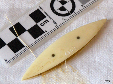 Flagstaff Hill Maritime Museum and Village
Tatting Shuttle
Tatting is a form of knotted lace making using thread and a small shuttle. Twisted threads are tied around or through small, pointed shuttles that can be made of bone, mother of pearl, tortoise shell, steel or plastic. This produces a stable, strong lace using simple knots of two half hitches to make rings and chains embellished with picots. The origins of tatting are not clear but early versions of decorative knotting were used by the Egyptians on their ceremonial dress. Tatting also has elements of fishermen's net making techniques and the decorative knotting that was practiced by aristocratic women from the 15th century. Tatting, as we know it today, emerged in the first half of the 19th century. The new availability of mercerised thread from 1835 encouraged a burgeoning of lace crafts of all sorts. It was known in Italy as "occhi" and in France as "la frivolite". Tatting looks fragile but is both strong and durable. An article in a column named "Wives and Daughters" published in the Star newspaper in May 1910 describes the durability of tatting lace - "there is edging and insertion still in existence that have outworn two sets of pillow slips." In the 19th century and well into the 20th century, tatting was used like crochet and knitted lace for decorative edgings, collars, doylies, tray cloths etc. At first, different tatting patterns were passed along by word of mouth from person to person, however in time, patterns regularly appeared in newspapers and magazines well into the 1950's. A shuttle is a small tool that looks like a small boat "sailing" in and out of the thread. Tatting is called "schiffchenarbeit" in German, which means "the work of a little boat". There are two popular types of shuttles. The first has closed ends and a removable bobbin where the thread is wound around - often made from metal or plastic. The second type has a post in the center where the thread is wound. The ends of this bobbin are open but snug. Because it is constructed in two pieces, it can be made from materials like bone, ivory or mother of pearl. Shuttles hold a larger amount of thread (as compared with needles) which means fewer ends to weave in. Fishermen in the past are thought to have used large shuttles to weave cord into certain knots whilst making their fishing nets. Their methods were copied by weavers, who innovated by using threads and smaller shuttles to make lace.Tatting Shuttle, Ivoryflagstaff hill, warrnambool, shipwrecked-coast, flagstaff-hill, flagstaff-hill-maritime-museum, maritime-museum, shipwreck-coast, flagstaff-hill-maritime-village, tatting shuttle, handcraft, needlework