Showing 4627 items
matching melbourne - maps
-
 Ringwood and District Historical Society
Map, Photocopy of Part of a map of Warrandyte -Yarra Valley area year unknown possibly c1930, c1930
Photocopy of Part of a map of Warrandyte -Yarra Valley area year unknown possibly c1930 -
Ringwood and District Historical Society
Badges, Badges and Coins 1939-45: 50 years of Queen Victoria's Reign; ANZAC Pins, King George and Queen Elizabeth; City of Wangaratta; etc, 1939 - 1945
Many issues - ANZAC DayBadges and coins. Refer photograph. +Additional Keywords: Pratt, G / GibbonTop Row L_R:; Victoria - 50 Years of Reign. Diam 3cm.; RDFA/Time Keeper (2 badges); Plastic 7-pointed badge (2 badges): Palestine-Gallipoli, FRANCE, Egypt, Mesopotamia, North Sea, New Guinea. In Centre: Lest We Forget printed across a map of Australia.; Assorted ANZAC pins/badges (5 badges); Middle Row L-R:; Side 1: King George VI & Queen Elizabeth (5 badges); Side 2: City of Wangaratta. Wangaratta Proclaimed a City.; Bottom Row:; Royal Life Saving Society, Established 1891. Centre: Awarded to G. Gibbon 1945.; Awarded to G Pratt v 1945; Victorian Rifle Association (2 badges); Legacy Badges/Pins (2 badges); Map of Australia on metal pin; Badge: Side 1 Centenary of Victoria 1934. On undeveloped scene embossed)/ Side 2 Centenary of Victoria 1935. (On city skyline embossed) Diam 2.6 cm.; Pavilion Fund Bayswater 1947-1948 -
Ringwood and District Historical Society
Book - Inventory, Ringwood Primary School Inventory book (text books,maps, etc). 1961-1969, 1961 - 1969
Ringwood Primary School No 2997. Book containing an inventory of text books, maps and requisites. Education Department Vic Form No. ST 673. The book has alphabetic index tabs; mottled green cover; red cloth spine.Inventory (The Pencraft Faint Indexed Account Book. A Pencraft Production.) -
 Ringwood and District Historical Society
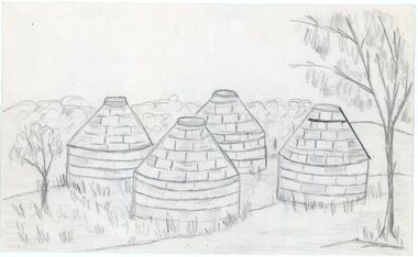
Work on paper - Pencil sketch, Artist unknown, initials D.M, Sketch of pottery kilns at East Ringwood, corner of Velma Grove and Mount Dandenong Road (Oxford Road). Kilns shut down in 1926, c.1926
Sketch of the four pottery kilns at East Ringwood, corner of Velma Grove and Mount Dandenong Road (Oxford Road). The kilns shut down in 1926. Judging by the handwriting, the artist and author appears to be John Rodaughan, East Ringwood historian, whose other works include history on Burnt Bridge Hotel and other parts of East Ringwood. The back of the sketch includes a rough hand-drawn map, that appears to be of the insulator works area, between Mt Dandenong Road and Evon Avenue. The timeline includes generic milestones in blue ink and those associated with Ringwood in red writing.Kilns; D.M. -
Ringwood and District Historical Society
Map, Ringwood -Montrose-Heathmont folded Map with ads for local businesses. C1960s
Front cover missing - ad for power cords and piston rings - originally back cover.White folded map from Ringwood > Montrose E > W and North Ringwood > Heathmont N > S surrounded by ads for local businesses. Not dated. -
Ringwood and District Historical Society
Map, Prepared by Commonwealth Section Imperial General Staff, Topographical map of Ringwood and surrounding areas dated 1-Aug-1935
... Road Ringwood North melbourne Ringwood Zone Topographical map ...Topographical map of Ringwood and surrounding areas dated 1-Aug-1935. Two copies.Ringwood Zone -
Ringwood and District Historical Society
Report Book, Education Department Victoria - Inspectors Report Book State School No 2997 Ringwood, May 1948 to April 1955, May 1948 - April 1955
Contains Inspector's Records and various maps and photographs relating to Ringwood School.Education Department Victoria - Inspectors Report Book State School No 2997 Ringwood, May 1948 to April 1955. -
Ringwood and District Historical Society
Report, Radden, W.W.L, History of Anderson's Creek 1856-1865 by W.W.L. Radden January 1965, Jan-65
History of Anderson's Creek 1856-1865 - 7 foolscap pages and map prepared by W.W.L. Radden January 1965 +Additional Keywords: Radden, W.W.L. -
 Ringwood and District Historical Society
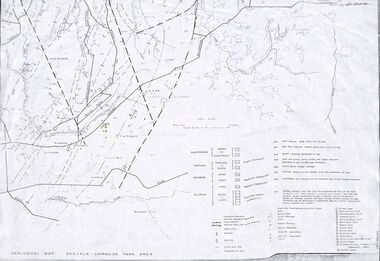
Map - Maps, Geological Map Donvale to Chirnside Park, also Victorian Railways Maps of Hawthorn to Lilydale Line incl Ringwood to East Ringwood - 1881
Faint photocopies of sections of larger maps. Geological map includes location of mine shafts circa 1920.Victory Shaft, North Victory Shaft, South Caledonia Shaft, Caledonia Shaft, North Caledonia Shaft, Black Swan Shaft, Reward Shaft, Consols Shaft, Blocks Shaft, Devonshire Shaft, Crown Shaft, Yarra Tunnel Reef Working, Bright's Shaft, Kingwood Antimony Company Shaft (Boardman's Shaft), Southern Shaft. -
Ringwood and District Historical Society
Map, Government Printer, Melbourne, Ringwood Zone Ordinance Survey Map, 1935
... Road Ringwood North melbourne Ordinance survey map glued ...Ordinance survey map glued to cheesecloth, of Ringwood zone - Commonwealth topographical map dated 1.8.35, scale 1:63,360. Information correct up to June 1922. "Ringwood 81" printed on the reverse side.; Envelope and note from donor of item, with return letter of appreciation from Ringwood & District Historical Society dated 20-May-2005. +Additional Keywords: Reid, Don -
Ringwood and District Historical Society
Survey map, Macey, H.J, Survey map of part of Ringwood 1917, 1917
Area corresponds to the present Eastlands complexPlan of the crown portion 12 of Parish of Ringwood, County of Mornington showing Adelaide Street and Whitehorse Road. Made by H.J. Macey, Licensed Surveyor 1917. -
Ringwood and District Historical Society
Memoirs, McKellar, Margaret et al, Text of talk to Ringwood Historical Society by Margaret and Ian McKellar - history of "Reaghill" and Davies Family. 2005, 24-Sep-05
The two articles give the history of the land subdivisions over the years, of "Reaghill", a house owned by the Davies family. The history of the land and family was given in a talk to Ringwood Historical Society by the McKellars in 2005.9 type-written pages. Pages 1-4 talk given by Margaret and Ian McKellar to the Ringwood Historical Society and a map. Pages 5-9 history of Reaghill and the Davies Family. +Additional Keywords: McKellar, Margaret / McKellar, Ian / Davies, George / Davies, Dora -
Ringwood and District Historical Society
Envelope, Packet: Ringwood - Property Owners 1871; Ratepayers 1890-01; Directory 1905; Maps of Area
1. 1871 property owners; 2. Rate paying electors Legislative Assembly 1890-91; 3. Ringwood Directory 1905; 4. Maps of area -
Ringwood and District Historical Society
Envelope, Packet: 4 maps Ringwood area c.1950
... Road Ringwood North melbourne 4 maps Ringwood area c.1950 ...4 maps Ringwood area c.1950 -
Ringwood and District Historical Society
Envelope, Packet: Maps of Ringwood from 1800s to late 1900s
... Road Ringwood North melbourne History 1974; Maps of Ringwood ...History 1974; Maps of Ringwood -
Ringwood and District Historical Society
Envelope, Packet: History of Ringwood Telecom Site; Maps. August 1985 Booklet. Clippings
History of Ringwood Telecom Site; Maps of area in Ringwood telephone system; Booklet "Welcome to the Phone Age" - August 1985 -
Ringwood and District Historical Society
Envelope, Packet: War Workers (WW2) - Fall of Singapore, Burma Railway Map, Special Editions of Newspapers 1992-993
World War II - Newspapers - 50th anniversary editions; The Australian - Special edition "The Fall of Singapore", "The Day Destiny Struck", Australia at War, Map of Burma Railway -
 Ringwood and District Historical Society
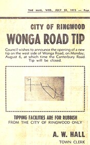
Newspaper - Newspaper Cutting, City of Ringwood, Victoria - opening of Wonga Road Tip by the council - 1973
Newspaper cutting from "The Mail" Wednesday July 25 1973 announcing the opening of Wonga Road Tip by the council. A.W. Hall, Town Clerk. (Accompanying map lacks readable navigation reference points/street names.) -
 Ringwood and District Historical Society
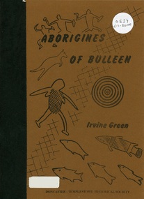
Book, Aborigines of Bulleen, 1989
Soft-cover book with indigenous artwork on brown cover with maps, drawings and photographs outlining the history of local indigenous people who inhabited the area which became the City of Doncaster and Templestowe. -
 Ringwood and District Historical Society
Book, A Tour of the Lilydale Cemetery 1861-1994 Volume One, 1995
... Road Ringwood North melbourne Map and history of some ...Map and history of some of the graves in Lilydale Cemetery, compiled By Sandy Ross, Lilydale and District Historical Society. +Additional Keywords: Mary Hussey / Daniel Cameron / Captain Alexander John Herbert Robertson / Ernest Buckmaster / Jimmy Ah Tak / David Mitchell / Dame Nellie Melba / Jessie Mary Vasey O.B.E., C.B.E. / William Blamire Young -
Australian Commando Association - Victoria
Equipment - Map board and case
... . melbourne Equipment Map board and case ... -
 Australian Commando Association - Victoria
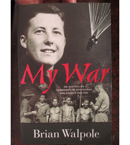
Book, My War: An Australian Commando in New Guinea and Borneo 1943 to 1945
Brian Walpole, the author, was a Australian Commando and special operations operative behind enemy lines in New Guinea and Borneo during WW2. Brian was a commando with the Australian 2/3 Independent Company. He went to New Guinea in January 1943 and remained until the fall of the Japanese base at Salamaua in September. He fought on the Bobdubi Ridge. His commanding officer was the well-regarded George Warfe, whose portrait was sketched by war artist Ivor Hele. Brian blazed a trail through the New Guinea jungle which appears on some maps as Walpole’s Track, discovering and naming the ambush site Goodview Junction. Soon afterwards (July 1943) Goodview Junction was the scene of a key campaign victory which contributed to George Warfe being awarded the Military Cross.Brian’s Special Operations training mostly took place at Careening Bay (Western Australia) and Fraser Island (Queensland). He arrived in Borneo at the time of the 9th Division’s landing at Labuan Island, and took part in two SRD operations – Colt and Semut 3. After the surrender, Walpole's work continued as many of the Japanese did not recognise the surrender and continued to fight on. Brian relates how on the 14th of September 1945 while still an operative in SRD he was able to save POWs from certain death and after a firefight arrested 10 Japanese soldiers at Simanggang Borneo. He was alone and had been assisted in the battle by 20 headhunters from the jungles along the Rejang River. One of the people saved was a young nurse in her 20s, Lena Ricketts. ww2, australian special operations, australian commando, new guinea, borneo, world war ii -
Australian Commando Association - Victoria
Equipment - Map Case
... . melbourne Equipment Map Case ... -
 Ringwood and District Historical Society
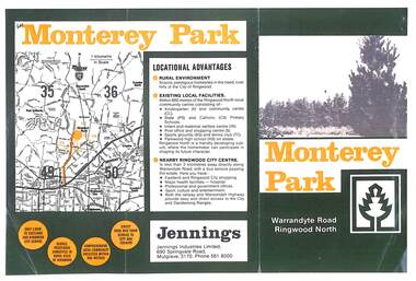
Flyer, Subdivisional Land Sale Brochure, Monterey Park, Warrandyte Road, Ringwood North, Vic. - circa 1980s
Two A4 size gloss paper pages advertising residential development including outline of local facilities and services, with locality map and layout of Monterey Park streets.Monterey Park - Jennings Industries Limited, 690 Springvale Road, Mulgrave, 3170, Phone 5618000. Subdivision includes Parkwood High School, Tortice Drive, Heape Way, Appleberry Place, Stringybark Court, Conifer Court, Crawley Grove, Monterey Close (later Monterey Place), Lucy Place, Middlebrook Drive, Gahnia Close, Glanfield Court, Cone Close, Jull Parade, Pinus Close (later Pinetree Court), Radiata Close, Old Warrandyte Road, and entry from Warrandyte Road. -
 Ringwood and District Historical Society
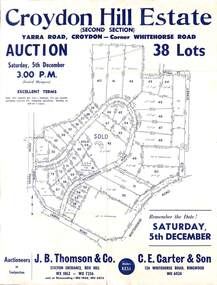
Flyer, Land Auction Sale Advertisement, Croydon Hill Estate, Croydon, Victoria - 1959
... Road Ringwood North melbourne Subdivision map includes ...Single sided land auction sale advertisement for 38 residential allotments - Croydon Hill Estate (Second Section) Yarra Road, Croydon - corner Whitehorse Road. Auction Saturday, 5th December, and corresponding newspaper advertisement - Ringwood Mail, Thursday, November 26, 1959.Subdivision map includes Richardson Road, Yarra Road, Whitehorse Road, Alice Street, Hull Street (later Mulawa Stret). Auctioneers in Conjunction: J.B. Thomson & Co., Station Entrance, Box Hill, (Telephone) WX 1862, WX 7356, and at Nunawading, WU 1968, WU 3452, and C.E. Carter & Son, 126 Whitehorse Road, Ringwood. WU 6024. -
 Ringwood and District Historical Society
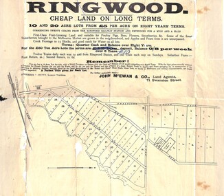
Flyer, Land Sale Advertisement, Ringwood, Victoria - 1894
... Road Ringwood North melbourne Subdivision map includes Mullum ...Land sale advertisement for 10 and 20 acre lots from £5 per acre on eight years' terms in Ringwood, with description of local facilities and agricultural features.Subdivision map includes Mullum Mullum Road, Wonga Road, Oban Road and Anderson's Creek Road (later Warrandyte Road). Markings on reverse side indicate the sheet was sent by post from John McEwan & Co., Auctioneers, Land Agents & Business Brokers, 71 Swanston Street, Melbourne, to Mr Allan, Builder, Ringwood, postmarked in JE (June), 1894. -
 Ringwood and District Historical Society
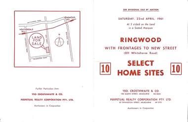
Flyer, Auction sale brochure advertising home sites with frontages to New Street, Ringwood, Victoria - 1961
... Road Ringwood North melbourne Location map showing land ...Advertisement for Sub-divisional sale by auction on Saturday, 22nd April, 1961, with terms of sale of 10 home sites with frontages to New Street, Ringwood, Victoria.Location map showing land for sale on New Street, Ringwood, north of Palmerston Road. Auctioneers in conjunction - Yeo, Crosthwaite & Co., 108 Queen Street Melbourne (Telephone) MU 8605, and Perpetual Realty Corporation Pty. Ltd., 62 Swanston Street, Melbourne (Telephone) MF 3721. -
 Ringwood and District Historical Society
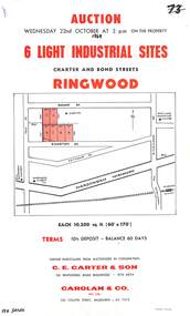
Flyer, Flyer advertising auction sale of light industrial sites in Ringwood, Victoria - 1969
Single page advertisement for auction sale of 6 light industrial sites in Charter Street and Bond Street in Ringwood on Wednesday 22nd October (1969).Advertisement includes terms of sale and location map. Auctioneers in Conjunction - C.E. Carter & Son, 126 Whitehorse Road Ringwood, (Telephone) 870 6024, and Carolan & Co. Pty. Ltd., 243 Collins Street, Melbourne, (Telephone) 63 7373. -
 Ringwood and District Historical Society
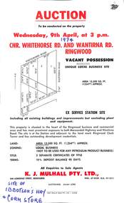
Flyer, Flyer advertising auction sale of ex service station site in Ringwood, Victoria - 1974
... Road Ringwood North melbourne Advertisement includes location ...Single page advertisement for auction sale of restricted business site, corner of Whitehorse Road and Wantirna Road, Ringwood, Victoria, on Wednesday, 9th April (1974).Advertisement includes location map and terms of sale of 3 separate certificates of title on land zoned as Restricted Business (Not to be used for any petroleum product business). Sole Agents - K.J. Mulhall Pty. Ltd., 358 Lonsdale Street, Melbourne (Telephone) 67 8338, A.H. 91 1511. Auctioneer - Allan Lord. Handwritten notation describes this as originally the site of Ibbotson's Hay and Corn Store. -
 Ringwood and District Historical Society
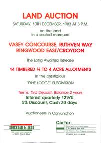
Flyer, Advertisement for land auction - Pine Lodge Subdivision, Ringwood East / Croydon, Victoria - 1983
Folded A3 double sided page advertising auction of 14 timbered allotments - 3/4 to 4 acres, on Saturday, 10th December, 1983, with terms of sale, location map, and summary of subdivision features.Subdivision includes Angus Avenue, Vasey Concourse and Ruthven Way, Ringwood East, and Cheong Street, Croydon, Victoria. A covenant has been placed on most titles specifying that only one dwelling house can be erected during the next ten years. Auctioneers in Conjunction - Stockdale & Leggo, 422 Collins Street, Melbourne, (Telephone) 67 6661, A.H. 20 2364, and C.E. Carter & Son, 122 Whitehorse Road, Ringwood, Victoria 3134, (Telephone) 870 6211, A.H. 876 4124.