Showing 116786 items
matching orbost-brodribb-road
-
 Ringwood and District Historical Society
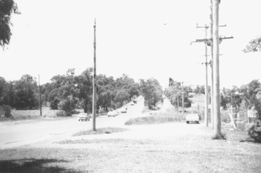
Photograph, Canterbury Road, Ringwood taken under power lines looking east just east of Heatherdale Road. 1979
Written on back of photograph, "Jan. 79. Canterbury Road taken under power lines looking east just east of Heatherdale Road looking up the two-laned Road towards Cadbury McRobertsons before road widening". -
 Ringwood and District Historical Society
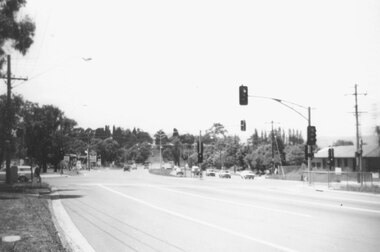
Photograph, Canterbury Road looking east from west side of Heatherdale Road intersection up towards Cadbury. Ringwood 1979
Written on back of photograph, "Jan. 79. Canterbury Road looking east from west side of Heatherdale Road intersection up towards Cadbury where road narrows down 3 to 1 lane. Before road widening." -
 Kew Historical Society Inc
Photograph, J F C Farquhar, A View in Studley Park Road, 1891
At the beginning of the 1890s, the Kew businessman and Town Councillor, Henry Kellett, commissioned J.F.C. Farquhar to photograph scenes of Kew. These scenes included panoramas as well as pastoral scenes. The resulting set of twelve photographs was assembled in an album, Kew Where We Live, from which customers could select images for purchase.The preamble to the album describes that the photographs used the ‘argentic bromide’ process, now more commonly known as the gelatine silver process. This form of dry plate photography allowed for the negatives to be kept for weeks before processing, hence its value in landscape photography. The resulting images were considered to be finely grained and everlasting. Evidence of the success of Henry Kellett’s venture can be seen today, in that some of the photographs are held in national collections.It is believed that the Kew Historical Society’s copy of the Kellett album is unique and that the photographs in the book were the first copies taken from the original plates. It is the first and most important series of images produced about Kew. The individual images have proved essential in identifying buildings and places of heritage value in the district.This is the earliest known photograph of the exterior of Byram (later Tara Hall). It shows the original red brick fence, its asymmetrical gate and gateposts, with a large terra cotta gargoyle surmounting the higher of the two. The architect, Edward Kilburn designed Byram in the Arts & Crafts style for the industrialist George Ramsden. Construction began in 1888 and was reputed to have lasted three years. The mansion had frontages to Studley Park Road and Stevenson Street, including gardens laid out with great taste, including pleasure grounds, tennis lawn, fruit and flower garden, and paddock. The size of many of the trees in the garden indicate that many survived from the garden of Clifton Villa, the previous single-storeyed house built on the site by the Stevenson brothers. Byram had views to Melbourne and Port Phillip Bay. The house was demolished in 1960, despite opposition from the National Trust (Victoria), and its gardens subdivided into residential allotments.A View in Studley Park Roadkew illustrated, kew where we live, photographic books, henry kellett, byram, tara hall, goathlands -
 Whitehorse Historical Society Inc.
Document, 520 Mitcham Road, 2005
Papers relating to objections to development of 520-528 Mitcham Road Mitcham.Papers relating to objections to development of 520-528 Mitcham Road Mitcham. Includes: statement by Neil Edwin Kerby & Margaret Anne Kerby; Title searches for 449 Mitcham Road Mitcham and adjacent properties; plan of 1906 subdivision; ASIC extract of development company organisational details; aerial photos of the area; photographs of nearby properties and of Mitcham Road streetscapes and list of Mitcham objectors. CD copy at NP3771Papers relating to objections to development of 520-528 Mitcham Road Mitcham. mitcham road mitcham, nos. 520-528, kerby, neil edwin, kerby, margaret anne, mitcham road mitcham no. 449, 520 mitcham road pty ltd, listermay nominees pty ltd, land subdivision -
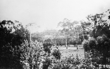
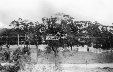
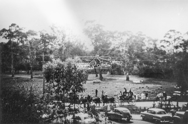
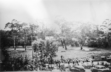
 Orbost & District Historical Society
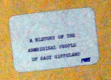
Document - File Folder, A History of Aboriginal People of East Gippsland, January 1985
This item is a useful reference tool on the history of Indigenous People in East Gippsland and the Orbost district. A manilla folder with typed pages. On the cover is a label, "History of Aboriginal People of East Gippsland". On the inside cover is a letter addressed to the librarian at the Shire of Orbost Library. The letter is clipped to the inside of the folder.on front cover - a stamp -"Orbost Historical Society"aboriginal australians, gippsland aboriginal history, kurnai, brabawooloong peoples, tatungooloong peoples, krowathunkooloong peoples -
 Ringwood and District Historical Society
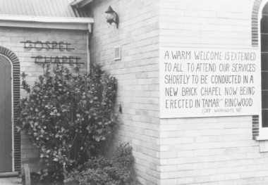
Photograph, Notice of Upcoming Closure of Ringwood Gospel Chapel in Warrandyte Road, Ringwood - 1974, 1974
Exterior view of Ringwood Gospel Chapel in Warrandyte Road, Ringwood, prior to relocation in 1974.Written on back of photograph, "5.10.74". The board on the Church says, "A warm welcome is extended to all. To attend our services shortly to be conducted in a new brick Chapel ... being erected in Tamar Street, Ringwood (off Warrandyte Road)." -
 Eltham District Historical Society Inc
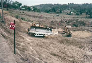
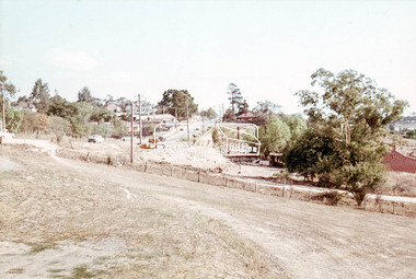
Photograph, Main Road widening, Eltham, c.March 1968, 1968
Immediately prior to duplication of Main Road. Looking south towards Bridge Street.35mm Colour positive transparency Mount - Agfacolor Service (Blue stepped)bridge street, duplication, eltham, main road -
 Eltham District Historical Society Inc
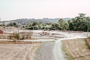
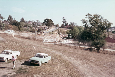
Photograph, Main Road widening, Eltham, c.March 1968, 1968
Duplication of Main Road. Looking towards Eltham Tip. Shillinglaw Cottage on left.35mm Colour positive transparency Mount - Agfacolor Service (Blue stepped)duplication, eltham tip, main road, shillinglaw cottage -
 Greensborough Historical Society
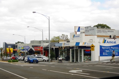
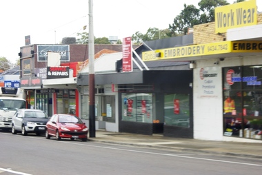
Photograph - Digital image, Marilyn Smith, Watsonia Road pharmacy, 2016, 24/05/2016
Watsonia Road Pharmacy, Watsonia 2016. The strip is managed by the Watsonia Traders Association.Digital copy of colour photograph.watsonia, watsonia road -
 Eltham District Historical Society Inc
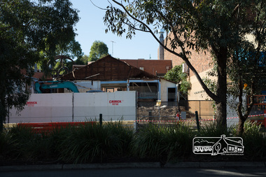
Photograph, Peter Pidgeon, Demolition of former Newsagency, Main Road, Eltham, 3 May 2017, 3 May 2017
Site of the former Newsagency on eastern side of Main Road. Thompson's Pharmacy to the leftBorn Digitaleltham, newsagency, main road, thompson's pharmacy -
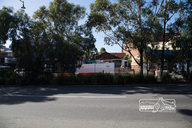 Eltham District Historical Society Inc
Photograph, Peter Pidgeon, Demolition of former Newsagency, Main Road, Eltham, 3 May 2017, 3 May 2017
Site of the former Newsagency on eastern side of Main Road. Thompson's Pharmacy to the leftBorn Digitaleltham, newsagency, main road, thompson's pharmacy -
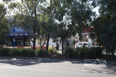
 Eltham District Historical Society Inc
Photograph, Peter Pidgeon, Demolition of former Newsagency, Main Road, Eltham, 3 May 2017, 3 May 2017
Site of the former Newsagency on eastern side of Main Road. Thompson's Pharmacy to the leftBorn Digitaleltham, newsagency, main road, thompson's pharmacy -
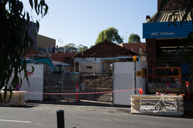
 Eltham District Historical Society Inc
Photograph, Peter Pidgeon, Demolition of former Newsagency, Main Road, Eltham, 3 May 2017, 3 May 2017
Site of the former Newsagency on eastern side of Main Road. Thompson's Pharmacy to the leftBorn Digitaleltham, newsagency, main road, thompson's pharmacy -
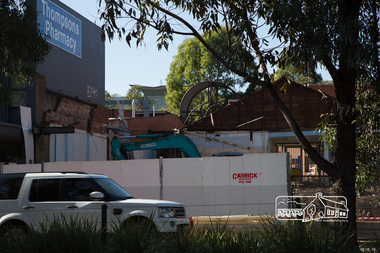 Eltham District Historical Society Inc
Photograph, Peter Pidgeon, Demolition of former Newsagency, Main Road, Eltham, 3 May 2017, 3 May 2017
Site of the former Newsagency on eastern side of Main Road. Thompson's Pharmacy to the leftBorn Digitaleltham, newsagency, main road, thompson's pharmacy -
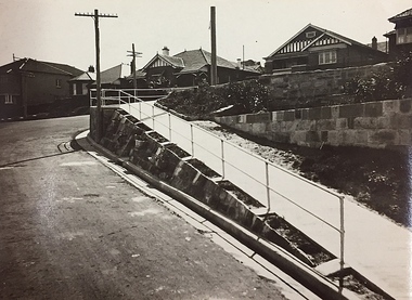 Kew Historical Society Inc
Photograph, City of Kew, Public Works, Road Making, c.1920s
An original photograph donated to the Kew Historical Society by the City's Engineering Department before the amalgamation of Kew into the City of Boroondara in 1994. While not all of the photographs are of Studley Park, Kew or East Kew, each photo provides a fine snapshot of the work of local government engineering departments of the period. They reveal they types of labour conducted, the techniques used and the equipment and machinery in the possession of the local government authority.Public works. A high retaining wall holds back an embankment on a steep slope around which a road turns. It is believed that the photograph dates from the 1920s. Inscription on reverse: "A difficult corner designed to obviate the use of steps. / Pedestrians using the road in front of the dwellings step off the pathway at the telegraph pole".city of kew (engineering department), engineering, road construction building -
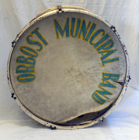 Orbost & District Historical Society
drum
This instrument was used by the Orbost Municipal Band. the Orbost Workers' Band and the Orbost Town Band amalgamated in 1913 to form the Orbost Municipal Band under the conductorship of Mr Charles Spink. The Orbost Municipal Orbost Band played a major role in the Orbost community activities. Charles Spink made sure each soldier returning home from the 1914 to 1918 war was welcomed home in front of the Shire Hall to the music of the Orbost Municipal Band. The band played in the main street on most Friday nights and in 1929 the band played at the official opening of the Buchan Caves, by Sir Albert Lind.A large drum painted white with green lettering. It is made of metal, wood and leather.Orbost Municipal Band on both sides of the drum.musical-instrument drum orbost municipal band spink-charles -
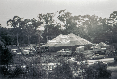 Eltham District Historical Society Inc
Slide - Photograph, Grace Mitchell, Ashtons Circus set up in Bremner's Reserve, Main Road, Eltham, c.1955
View from Grace Mitchell's shop at the corner of Mount Pleasant Road and Main Road. Grace Mitchell was probably best known for her Eltham shop at the corner of Mt Pleasant Road and Main Road. Grace's memories covered many local identities who were patrons of her shop between 1954 and 1971. From the elevated position of her shop and home Grace was able to view a varied passing parade of Eltham events from ERSILAC, Easter and Eltham Festival parades passing on their way to Eltham Lower Park, circuses in Wingrove Park (then Bremner’s Reserve), roadworks and other happenings. Bremner's Reserve was renamed Wingrove Park c.1970 This photo was from a series of images presented by Grace Mitchell at a Society talk 10 March 1993 on the theme of “My Eltham”.35mm Kodak 5052 TMX Black and White transparency, 1 strip, 6 frames Black and white print 17 x 25.4 cmashtons circus, bremner's flat, circus, grace mitchell, main road, mount pleasant road, wingrove park -
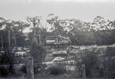
 Eltham District Historical Society Inc
Photograph, Grace Mitchell, Bremners Flat, Main Road, Eltham, 1958c
View from Grace Mitchell's shop at the corner of Mount Pleasant Road and Main Road. Grace Mitchell was probably best known for her Eltham shop at the corner of Mt Pleasant Road and Main Road. Grace's memories covered many local identities who were patrons of her shop between 1954 and 1971. From the elevated position of her shop and home Grace was able to view a varied passing parade of Eltham events from ERSILAC, Easter and Eltham Festival parades passing on their way to Eltham Lower Park, circuses in Wingrove Park (then Bremner’s Reserve), roadworks and other happenings. Bremner's Reserve was renamed Wingrove Park c.1970 This photo was from a series of images presented by Grace Mitchell at a Society talk 10 March 1993 on the theme of “My Eltham”.Black and white print 17 x 25.4 cmbremner's flat, main road, mount pleasant road, wingrove park -
 Eltham District Historical Society Inc
Photograph, Grace Mitchell, Diamond Creek in flood, Bremners Flat, Main Road, Eltham, c.1958
View from Grace Mitchell's shop at the corner of Mount Pleasant Road and Main Road. Grace Mitchell was probably best known for her Eltham shop at the corner of Mt Pleasant Road and Main Road. Grace's memories covered many local identities who were patrons of her shop between 1954 and 1971. From the elevated position of her shop and home Grace was able to view a varied passing parade of Eltham events from ERSILAC, Easter and Eltham Festival parades passing on their way to Eltham Lower Park, circuses in Wingrove Park (then Bremner’s Reserve), roadworks and other happenings. Bremner's Reserve was renamed Wingrove Park c.1970 This photo was from a series of images presented by Grace Mitchell at a Society talk 10 March 1993 on the theme of “My Eltham”.Black and white print 17 x 25.4 cmbremner's flat, diamond creek, floods, main road, mount pleasant road, wingrove park -
 Eltham District Historical Society Inc
Photograph, Grace Mitchell, Possibly the Ersilac Parade travelling along Main Road, Eltham, c.1958
View from Grace Mitchell's shop at the corner of Mount Pleasant Road and Main Road. Grace Mitchell was probably best known for her Eltham shop at the corner of Mt Pleasant Road and Main Road. Grace's memories covered many local identities who were patrons of her shop between 1954 and 1971. From the elevated position of her shop and home Grace was able to view a varied passing parade of Eltham events from ERSILAC, Easter and Eltham Festival parades passing on their way to Eltham Lower Park, circuses in Wingrove Park (then Bremner’s Reserve), roadworks and other happenings. Bremner's Reserve was renamed Wingrove Park c.1970 This photo was from a series of images presented by Grace Mitchell at a Society talk 10 March 1993 on the theme of “My Eltham”.Black and white print 17 x 25.4 cmcars, bremner's flat, eltham, ersilac parade, main road, mount pleasant road, wingrove park, festival, horse drawn carriage -
 Eltham District Historical Society Inc
Photograph, Grace Mitchell, Possibly the Ersilac Parade travelling along Main Road, Eltham, 1958c
View from Grace Mitchell's shop at the corner of Mount Pleasant Road and Main Road. Grace Mitchell was probably best known for her Eltham shop at the corner of Mt Pleasant Road and Main Road. Grace's memories covered many local identities who were patrons of her shop between 1954 and 1971. From the elevated position of her shop and home Grace was able to view a varied passing parade of Eltham events from ERSILAC, Easter and Eltham Festival parades passing on their way to Eltham Lower Park, circuses in Wingrove Park (then Bremner’s Reserve), roadworks and other happenings. Bremner's Reserve was renamed Wingrove Park c.1970 This photo was from a series of images presented by Grace Mitchell at a Society talk 10 March 1993 on the theme of “My Eltham”.Black and white print 17 x 25.4 cmcars, bremner's flat, eltham, ersilac parade, main road, mount pleasant road, wingrove park, festival, horse drawn carriage -
 Eltham District Historical Society Inc
Photograph, Grace Mitchell, Possibly the Ersilac Parade travelling along Main Road, Eltham, c.1958
View from Grace Mitchell's shop at the corner of Mount Pleasant Road and Main Road. Grace Mitchell was probably best known for her Eltham shop at the corner of Mt Pleasant Road and Main Road. Grace's memories covered many local identities who were patrons of her shop between 1954 and 1971. From the elevated position of her shop and home Grace was able to view a varied passing parade of Eltham events from ERSILAC, Easter and Eltham Festival parades passing on their way to Eltham Lower Park, circuses in Wingrove Park (then Bremner’s Reserve), roadworks and other happenings. Bremner's Reserve was renamed Wingrove Park c.1970 This photo was from a series of images presented by Grace Mitchell at a Society talk 10 March 1993 on the theme of “My Eltham”.Black and white print 17 x 25.4 cmcars, bremner's flat, eltham, ersilac parade, main road, mount pleasant road, wingrove park, festival, horse drawn carriage -
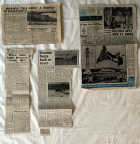 Orbost & District Historical Society
newspaper clippings, mid 20th century?
This folder of newspaper articles was compiled by Mary Gilbert. Mary Isabelle Gilbert was born in 1905 in Orbost, Australia. She was born to John Gilbert and Annie Cameron Gilbert, and had seven sisters and one brother. Four siblings died at a young age. .She was a teacher historian loved and respected by her family and the wider community. The articles are generally pertaining to Gabo and Point Hicks.These articles are contemporary records of interest in places close to Orbost and are a useful reference tool.A manila folder of black / white newspaper articles relating to Orbost and the surrounding district. 744.2 is titled, " Miranda Tells About a Holiday at Mallacoota". 744.3 is from the Snowy River Mail and is titled, " Historic Spot Now Pt Hicks". 744.4 is from the Snowy Mail and is titled, "Riverina Floats Back on Beach". 744.5 is from the Snowy River Mail and has three articles: "When Gabo Light Keepers Nearly Quit"; "Sydney Convicts For Gabo?'; "Nothing to Eat But Shark".newspaper-articles-gabo- point hicks riverina -
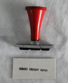 Orbost & District Historical Society
stamp, 1970's
This stamp was used at the Orbost Railway Station. The Bairnsdale-Orbost railway was opened in 1916 to serve the agricultural and timber industry. Because of the decline in traffic and heavy operating costs, the line was finally closed in August, 1987. Orbost Railway Station was opened on Monday 10 April 1916 as the terminus of the Orbost railway line, and closed in 1987. The station was located on the west side of the Snowy River despite the town of Orbost being on the east side of the river, in order to save on the costs of a bridge over the river, which at the time had highly variable levels, This item is associated with the history of the Orbost-Bairnsdale railway line and therefore reflects the role that the rail line played in the social and economic history of Orbost.A stamp with a red plastic handle and a white stamping face - "ORBOST FREIGHT DEPOT".VUESTAMP AUSTRALIAorbost-railway -
 Eltham District Historical Society Inc
Photograph, Main Road widening, Eltham, c.March 1968, 1968
Immediately prior to duplication of Main Road. Gahan house on left and Shire Offices in background35mm Colour positive transparency Mount - Agfacolor Service (Blue stepped)duplication, eltham, eltham shire office, gahan house, main road, road construction -
 Eltham District Historical Society Inc
Photograph, Main Road widening, Eltham, c.March 1968, 1968
Duplication of Main Road. Gahan House almost completely demolished. Shillinglaw Cottage on right.35mm Colour positive transparency Mount - Agfacolor Service (Blue stepped)duplication, gahan house, main road, shillinglaw cottage -
 Eltham District Historical Society Inc
Photograph, Main Road widening, Eltham, c.March 1968, 1968
Duplication of Main Road. Gahan House almost completely demolished. Shillinglaw Cottage on right.35mm Colour positive transparency Mount - Agfacolor Service (Blue stepped)duplication, gahan house, main road, road construction, shillinglaw cottage -
 Greensborough Historical Society
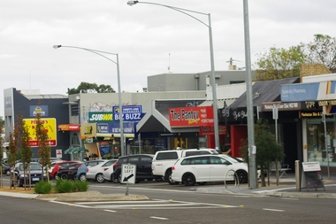
Photograph - Digital image, Marilyn Smith, Watsonia Road shopping strip, 2016, 24/05/2016
Watsonia Road shopping strip, Watsonia 2016. The strip is managed by the Watsonia Traders Association.Digital copy of colour photograph.watsonia, watsonia road -
 Greensborough Historical Society
Photograph - Digital image, Marilyn Smith, Watsonia Road shopping strip 2, 2016, 24/05/2016
Watsonia Road shopping strip, Watsonia 2016. The strip is managed by the Watsonia Traders Association.Digital copy of colour photograph.watsonia, watsonia road