Showing 178340 items
matching pitt-street
-
 Clunes Museum
Book, MRS. GOTHER MANN, THE FOUR HOMES, CIRCA 1880
The Four Homes is a novel written by Valerie Boissier De Gasparin and published in 1878. The book tells the story of four different households, each representing a different social class and way of life. The first home is that of a wealthy aristocratic family, the second is a middle-class family struggling to make ends meet, the third is a poor family living in a crowded tenement, and the fourth is a group of homeless people living on the streets.ADAPTED FROM THE FRENCH AUTHOR MADAME DE GASPARIN, BY MRS. GOTHER MANN.fictionThe Four Homes is a novel written by Valerie Boissier De Gasparin and published in 1878. The book tells the story of four different households, each representing a different social class and way of life. The first home is that of a wealthy aristocratic family, the second is a middle-class family struggling to make ends meet, the third is a poor family living in a crowded tenement, and the fourth is a group of homeless people living on the streets.local history, book, novel, hudson, laura -
Clunes Museum
Book, McCARRON BIRD & CO. MELBOURNE, ADDRESS TO HIS MAJESTY KING EDWARD VII, 1901
PRESENTED TO ROBERT DOLAN WITH THE COMPLIMENTS OF THE EXECUTIVE COMMITTEE OF THE MUNICIPAL ASSOCIATION OF VICTORIA 1901. ADDRES TO HIS MAJESTY KING EDWARD VIII.ROYAL BLUE COVERED BOOK. GOLD PRINTING.ROBERT DOLANlocal history, document memorials and addresses., books history -
Clunes Museum
book, 'ADVERTISER' PRINTING WORKS , HIGH STREET, MARYBOROUGH, THE HOUSEWIFE'S COMPANION, C 1916
THE CONTENT OF THIS BOOK IS COOKING RECIPESCOOKERY BOOK - "THE HOUSEWIFE'S COMPANION"THE CONTENT OF THIS BOOK IS COOKING RECIPESlocal history, cookery, -
Clunes Museum
Document - REPORT, F.W.NIVEN PRINTERS AND LITHOGRAPHERS STURT STREET, BALLARAT, 1888
REPORT AND STATISTIC OF THE SOUTH CLUNES UNITED COMPANIE'S MINE CLUNES VICTORIA 1888local history, document, report, mining -
Clunes Museum
Newspaper - NEWSPAPER-CUTTING, CLUNES "GUARDIAN OFFICE" FRASER STREET CLUNES, JULY 28TH 1933
ORIGINAL CLUNES GUARDIAN&GAZETTE.ONE COPY OF CLUNES GUARDIAN AND GAZETTE, FRIDAY JULY 25TH 1933 ONE PENNY GREEN STAMPlocal history, document, newspaper cutting, -
Clunes Museum
Newspaper, V.J. SANDFORD,ALBERT STREET, CRESWICK
CRESWICK ADVERTISER ISSUED ON FRIDAY 24TH JANUARY 1969.local history, documents, newspapers, creswick advertiser -
Clunes Museum
Newspaper, V.J. SANDFORD, ALBERT STREET, CRESWICK
ARTICLES RELATING TO FIRES IN THE DISTRICT ON WEDNESDAY 8TH. JANUARY 1969.CRESWICK ADVERTISER ISSUED ON FRIDAY 24TH JANUARY 1969.local history, documents, newspaper, creswick advertiser -
Clunes Museum
Newspaper, GRAHAM STANLEY BULLUSS, FOREST STREET, WENDOUREE
BALLARAT COURIER ISSUED ON TUESDAY 9TH JANUARY 1969local history, documents, newspaper, ballarat courier -
Clunes Museum
Newspaper, V.J. SANDFORD ALBERT STREET, CRESWICK
ARTICLE RELATING TO GRASS FIRE IN THE DISTRICT ON WEDNESDAY 8TH JANUARY 1969CRESWICK ADVERTISER ISSUED ON FRIDAY JANUARY 10,1969local history, documents, newspaper, -
Clunes Museum
Newspaper, LESLIE PEARCE, FRASER STREET, CLUNES
CLUNES - TALBOT GUARDIAN ISSUED ON FRIDAY, DECEMBER 9TH 1960local history, documents, newspaper, clunes talbot guardian newspaper -
Clunes Museum
Newspaper, GRAHAM STANLEY BULUSS, FOREST STREET, WENDOUREE
ARTICLES RELATING TO FIRES IN THE DISTRICT ON WEDNESDAY 8TH JANUARY 1969.BALLARAT COURIER ISSUED ON FRIDAY, 10TH JANUARY 1969.local history, documents, newspaper, ballarat courier -
 Clunes Museum
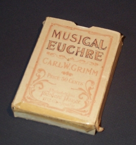
Domestic object - PACK OF CARDS, CARL W. GRIMM
PACK OF PLAYING CARDS FOR MUSICAL EUCHRElocal history, persopnel effects, playing cards -
Clunes Museum
Book, "THE PAKENHAM GAZETTE", MAIN STREET, PAKENHAM, A VALLEY OF THE FINEST DESCRIPTION, 1985
A SOCIAL AND ENVIRONMENTAL HISTORY OF LEXTON SHIRE.BLUE BOUND BOOK WITH THE SHIRE OF LEXTON SEAL IMPRINTED IN GOLD LETTERING ON THE FRONT COVER, COMPLETE WITH DUST JACKET DEPICTING AN IMAGE OF A HORSE TEAM ENTERING THE TOWNSHIP OF LEXTON WITH THE PYRENEES HOTEL AND THE LEXTON COURT HOUSE, DERIVED FROM A PAINTING BY ANN MCGREGORD OF BURNBANK. 360 PAGESnon-fictionA SOCIAL AND ENVIRONMENTAL HISTORY OF LEXTON SHIRE.local history, book, history, lexton -
 Clunes Museum
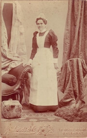
Photograph, RICHARDS & CO. 19 STURT STREET, BALLARAT
SEPIA PHOTOGRAPH OF MATRON ADA JOHNSON IN HER NURSES UNIFORM - STARCHED COLLAR AND CUFFS. WEARING A CAP. HER HAND ON SOFA, EMBOSSED CURTAINS DRAPED AROUND.On reverse hand written in blue biro; Mrs Ada Johnson, matron of Clunes Hospital for quite a few years and during 1st World War 1914-1918 when the town was without a doctor. Her experience and knowledge was a great asset to Clunes. Retired about 1921photographs, hospital [old], matron ada johnson -
 Clunes Museum
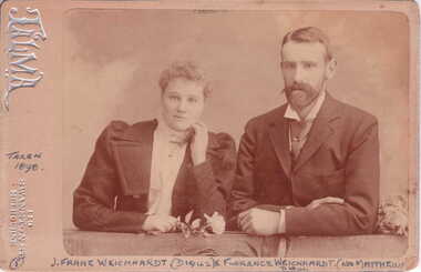
Photograph, TALMA 119 SWANSON STREET, MELBOURNE, 1898
MR. AND MRS. WEICKHARDT ARE OLD CLUNES IDENTITESSEPIA PHOTOGRAPH OF J. FRANZ WEICKHARDT D. 1942 AND HIS WIFE FLORENCE - NEE MATHEWS, TAKEN 1898 - MRS. WEICKHARDT WEARING A WHITE HIGH NECK BLOUSE OVER A DARK COSTUME HOLDING A ROSE. MR. WEICKHARDT WEARING A DARK SUIT AND WHITE COLLAR SHIRT.photographs, weickhardt, franz weickhardt, florence weickhardt -
Clunes Museum
Book - REFERENCE BOOK, EDGAR H. BAILLIE, 185 BALACLAVA ROAD, CAULFIELD FOR UNITED PRESS, THE HOME BEAUTIFUL TATTING
INSTRUCTION BOOK USED BY MRS. W. HARRIS (FORMERLY ROSEMARY GORDON)THE HOME BEAUTIFUL TATTING BOOK INSTRUCTIONS FOR MORE THAN SIXTY DESIGNS BY NORMA BENPORATHROSEMARY GORDONbook, books - reference, tatting book, home beautiful -
 Clunes Museum
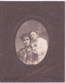
Photograph, YEOMAN CO. BOURKE STREET, MELBOURNE
ON BACK OF PHOTOGRAPH "CLARA" MRS CROSS & CHILD HUSBAND A..... OLIVER.OVAL PHOTOGRAPH OF LADY WITH A YOUNG BOY LEANING ON HER LEFT SHOULDER. SHE IS WEARING A HIGH NECKED DARK CAPE. THE BOY A WHITE SUIT.THE COMPLIMENTS OF THE SEASON . IN GOLD WRITING.local history, photography, photographs, early citizens -
 Clunes Museum
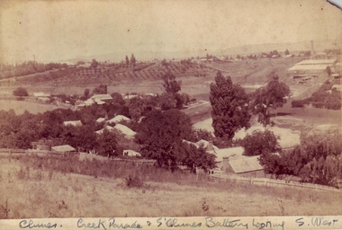
Photograph, J. BAWDEN PHOTOGRAPHERS, FRASER STREET, CLUNES
SEPIA PHOTOGRAPH OF CREEK PARADE, CLUNES, AND SOUTH CLUNES BATTERYCLUNES CREEK & CLUNES BATTERY LOOKING SOUTH WESTlocal history, photography, photographs, clunes landscape -
Clunes Museum
Headwear - HEAD CAP, FAIRMARK 81 HIGH STREET, PRESTON, VICTORIA P.O.BOX 1630, PRESTON 3072
WESLEY CAP INCLUDED IN SHOWBAGPURPLE HEAD CAP WESLEY - PART OF COLLEGE UNIFORM WITH COLLEGE CRESTmale headwear, schools, wesley, cap -
 Clunes Museum
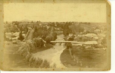
Photograph, J. BAWDEN PHOTOGRAPHER STUDIO FRASER STREET, CLUNES, CIRCA 1890
TULLAROOP CREEK FROM "ROCKS" NEAR SITE OF PORT PHILLIP MINE. ABOUT 1890 - NOTE GOVERNMENT BRIDGE IN DISTANCE. THIS WAS REBUILT IN STRAIGHT STEEL GIRDERS IN 1896.ORIGINAL SEPIA PHOTOGRAPH OF TULLAROOP CREEK, IN FOREGROUND VIEWS OF CLUNES TOWNSHIP. TWO MILE HILL IN LEFT FAR DISTANCE. (SUSPENSION BRIDGE IN FOREGROUND)local history, photography, bridges - buildings and landscape of clunes -
Clunes Museum
Drawing - LITHOGRAPH, F.W. NIVEN, STURT STREET, BALLARAT
FRAMED PEN & PASTEL DRAWING OF THE SURFACE WORKS OF THE PORT PHILLIP & COLONIAL MINING COMPANY.lithograph, port philip mine, fw niven -
 Clunes Museum
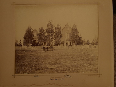
Photograph, BEAUCHAMP, PHOTO. 104 STURT STREET, BALLARAT, CIRCA 1888 - 1890
UPPER STOREY OF THE HOSPITAL WAS REMOVED DURING THE 1930'S THE BUILDING WAS DESTROYED IN A BUSHFIRE IN JANUARY 1944. PHOTOGRAPH OF THE OLD CLUNES HOSPITAL, BUILD IN 1873. WRITTEN IN INK UNDER PICTURE POINTS OF INTEREST .1 SEPIA PHOTOGRAPH MOUNTED ON MATT BOARD .2 PHOTO PRINT OF ABOVE PHOTO - BLACK AND WHITE .3 PHOTOCOPY ON PHOTO PAPER - BLACK AND WHITE .4 SEPIA PHOTOGRAPH MOUNTED ON MATT BOARD .5 COPY OF SEPIA PHOTOGRAPH MOUNTED ON MASONITETHE HOSPITAL. BEAUCHAMP PHOTO 104 STURT ST BALLARATlocal history, photography, photographs, hospital [old] -
Clunes Museum
Certificate, J.W. PEARSON, 3 COLLINS STREET, MELBOURNE, 6.8.1868
MEMBER CARD CLUNES MORNING STAR. PRESENTED TO JULIA HEARN AS A MEMBER BAND OF HOPE.document, certificates, julia hearn, clunes morning star -
Clunes Museum
Newspaper, J R INGUS ALBERT STREET, CRESWICK, 1978
NOTE THE PASSING OF MRS. JEAN PEART - A VALUED CITIZEN OF CLUNES AND DISTRICT NEWS ITEMS AND ADVERTISEMENTS.PHOTO COPY CRESWICK ADVERTISER WEDNESDAY MAY 3 1978 SEVEN PAGE COLLECTION. LOCAL NEWS AND ADVERTISEMENTS. PRICE 10 CENTSE. JONESlocal history, document, newspaper, obituary -
Clunes Museum
Book, ROBERT BELL AND ASSOCIATES P/L BALLARAT, LIST OF THOSE WHO PURCHASED LAND AT AUCTION IN BUNINGYONG 1851-1856, 2001
HISTORICAL TRANSCRIPTION AND COMPLATION OF LAND PURCHASED AT BUNINYONG MID 1800'SORANGE COVERED BOOKLET WITH THE TITLE PRINTED ON THE FRONT COVERnon-fictionHISTORICAL TRANSCRIPTION AND COMPLATION OF LAND PURCHASED AT BUNINYONG MID 1800'Slocal history, book, buninyong -
Clunes Museum
Book, ROBERT BELL AND ASSOCIATES BALLARAT, DICTIONARY OF AUSTRALIAN ARCHITECTUAL TERMS, 2001
DICTIONARY OF AUSTRALIAN ARCHITECTURAL TERMSYELLOW COVERED BOOKLET, TITLE AND AUTHOR'S NAME IN BLACK INK OF FRONT COVER. 32 PAGESnon-fictionDICTIONARY OF AUSTRALIAN ARCHITECTURAL TERMSlocal history, dictionary, arcitectural guide book -
Clunes Museum
Booklet, ROBERT BELL AND ASSOCIATES BALLARAT 3354, WAS GRANDPA THE GRANDMASTER? - A GUIDE TO IDENTIFYING FREEMASON ON LOCAL AND FAMILY HISTORY, 2001
A GUIDE TO IDENTIFYING FREEMASONS IN LOCAL AND FAMILY HISTORY. BY ROBERT W BELLPALE GREEN COVERED BOOKLET WITH A BLACK INK IMAGE OF A FREEMASON'S COMPASS AND SET SQUARE ON THE FRONT COVER 36 PAGESnon-fictionA GUIDE TO IDENTIFYING FREEMASONS IN LOCAL AND FAMILY HISTORY. BY ROBERT W BELLlocal history, guide, lodge, freemason -
Clunes Museum
Plaque - NAME PLATE, CUMPSONS ENGRAVING WORKS, PTY. LTD.379 HAY STREET, EAST PERTH
NAME PLATE OF DOCTOR MARK FOWLER, RESIDENT DOCTOR IN CLUNES IN THE 1950 S.A CHROME DOCTORS NAME PLATEDR. MARK FOWLER PHYSICIAN & SURGEONlocal history, signs, medicine -
Moorabbin Air Museum
Book - UNDER THE GUNS OF THE RED BARON, NORMAN FRANKS et al, 1995
-
Moorabbin Air Museum
Book - AIR BATTLE FOR DUNKIRK 26 MAY - 3 JUNE 1940, NORMAN L.R. FRANKS, 1983