Showing 11125 items
matching planning.
-
 Whitehorse Historical Society Inc.
Pamphlet, Morack Public Golf Course, c1985
Pamphlet describing the Morack Public Golf Course in Vermont South.Pamphlet describing the Morack Public Golf Course in Vermont South. Its history is outlined and its proposed development. Course maintenance and watering systems are described. The verso is a detailed plan of the course.Pamphlet describing the Morack Public Golf Course in Vermont South. morack golf course, dandenong valley metropolitan park -
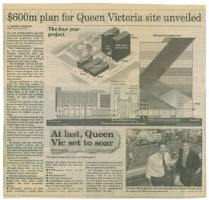 Queen Victoria Women's Centre
Newspaper clipping, Wayne Taylor, $600m plan for Queen Victoria site unveiled, 21 February 2001
Unveiling of the QV plans by Groconnewspaper clipping from The Age. Graphic representing the works to be done on the QV block between Swanston street and Russell street. Black and white photo at the bottom of page of Premier Steve Bracks with director of Grocon, Daniel Grollo after the plans for QV were announced. building construction, historic building, civic centres, town planning -
 Kew Historical Society Inc
Plan - Subdivision Plan, Doona Estate, Toorak, 1929
The Kew Historical Society collection includes almost 100 subdivision plans pertaining to suburbs of the City of Melbourne. Most of these are of Kew, Kew East or Studley Park, although a smaller number are plans of Camberwell, Deepdene, Balwyn and Hawthorn. It is believed that the majority of the plans were gifted to the Society by persons connected with the real estate firm - J. R. Mathers and McMillan, 136 Cotham Road, Kew. The Plans in the collection are rarely in pristine form, being working plans on which the agent would write notes and record lots sold and the prices of these. The subdivision plans are historically significant examples of the growth of urban Melbourne from the beginning of the 20th Century up until the 1980s. A number of the plans are double-sided and often include a photograph on the reverse. A number of the latter are by noted photographers such as J.E. Barnes.The Doona Estate subdivision of 1929 created 11 new allotments bordered by Glenferrie Road, Stonnington Place, Cross and Church Streets. On the right of the plan, the location of ‘State Govt. House’ is noted. Stonnington was to be maintained as Victoria’s Government House until 1931, two years after the Doona Estate subdivision was released.subdivision plans - toorak, doona estate -
 Bacchus Marsh & District Historical Society
Map, Plan of Survey of Part of Crown Allotment 9, Parish of Korkuperrimul, 1890
This map documents a transfer of an allotment of land in Clarke Street Bacchus Marsh in 1890. Clarke Street is located on the eastern side of Bacchus Marsh not far from Main Street and Crook Street. It is now known as Candeloro Street. The map indicates J. Booth as the owner of the land and H. Simpson as the occupier. Next to this allotment is a an allotment of land owned by J. Elmore,Single page map showing Crown allotment 9, Parish of Korkuperrimul, County of Bourke. Scale 100 feet to inch. Part of a set of maps which are pasted into a bound volume containing 76 maps or plans in total. High resolution digital image stored on BMDHS computer network. At bottom of map: I hereby certify that I have made this survey expressly for the purpose of an application under the Transfer of Land Statute that this plan is correct. Barry B???, Lic. Surveyor, 16.10.90bacchus marsh victoria maps, clarke street bacchus marsh maps -
 Melbourne Tram Museum
Drawing, Melbourne & Metropolitan Tramways Board (MMTB), Aerial photographs Bundoora Tram Extensions, Plenty Road – MMTB Drawings – 12/1979, Bundoora Extension – Metropolitan Transit Authority – 2/1983, John-Connell – Mott Hay and Anderson – Preliminary drawings for the Latrobe Modal Interchange – August 1984, 1979 to 1984
Set of drawings for the MMTB Plenty Road extension in 1979, MTA extension to Bundoora in 1983 and the Latrobe Uni Modal Interchange - 1984. Large print – Aerial photographs Bundoora Tram Extensions Stage 2 – Albert St to Kingsbury Drive Stage 3 – Kingsbury Drive to Settlement Road Has been rolled, left hand edge damaged, right hand edge torn Compiled by the ROW Division – 2/1981. Has written on rear at right hand end “Bundoora Tram Extension – Official MMTB Plans” 760H x 1190W Plenty Road – MMTB Drawings – 12/1979 P15123 Tyler St to Walsal Avenue P15124 Walsal Ave t McColl St P15125 McColl St to Dorrington Avenue Bundoora Extension – Metropolitan Transit Authority – 2/1983 P15400 Dorrington Avenue to Barwon Avenue P15401 Barwon Avenue to Nicholson Ave P15402 Nicholson St to Barling Park P15403 Barling Park to Darebin Creek P15404 Darebin Creek to Scott Grove P15405 Scott Grove to Clunes Street P15406 Clunes St to Cash St P15408 Cash St to Bundoora Park P15409 Bundoora Park to Larundel Hospital P15410 At Larundel Hospital P15411 Larundel Hospital to Marne Court P15412 Marne Court to Cherrywood Court P15413 Cherrywood Court to Morwell Ave P15414 Morwell Ave to Grimshaw St P15415 Grimshaw St to Nickson Street P15416 Nickson St to McLeans Road John-Connell – Mott Hay and Anderson – Preliminary drawings for the Latrobe Modal Interchange – August 1984. 8094-A-20 Set Out Plan and Paving Details 8094-A-21 Elevations 8094-A-22 Sections 8094-A-23 Roof Plan and Stormwater Layout 8094-A-24 Canopy Details 8094-A-25 Toilet Block and Waiting Room 8094-A-28 Miscellaneous DetailsOn rear of aerial photograph sheet - at right hand end “Bundoora Tram Extension – Official MMTB Plans” in felt pen.trams, tramways, plenty rd, bundoora, latrobe university, mmtb, construction, mta -
 Federation University Historical Collection
Plan, Smythesdale, County of Grenville, 01/12/1892
This plan is associated with former Ballarat School of Mines Student Richard Squire (1875-1876). Gift of the Squire FamilyA plan showing the Borough of Smythesdale, Smythesdale, Browns and Scarsdale, allotments, water reserve, Timber reserve, Nintingbool Pre-emptive Right, Reserve for public gardens, Reserve for Cricket Ground, Reserve for Reservoirsmythesdale, scarsdale, browns, yarrowee, carngham, samuel barlett, sheridan, wrigley, p. land, r. simpson, d. davis, nintingbool, mclachlan, a. mclachlan, c. taylor, w. c. smith, d. davies, w. williams, m. jones, t. mcgurk, r. selkirk, a. mooney -
 Whitehorse Historical Society Inc.
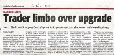
Article, North Blackburn Shopping Centre, 2017
Mr Harvey of the North Blackburn Shoe Repair is wanting to sell his business.Mr Harvey of the North Blackburn Shoe Repair is wanting to sell his business but the North Blackburn Shopping Centre will not renew his lease beyond Sep 2019 due to plans to upgrade the Centre.Mr Harvey of the North Blackburn Shoe Repair is wanting to sell his business.north blackburn square shopping centre, australian unity, north blackburn shoe repair, harvey, stewart -
 Robin Boyd Foundation
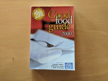
Book, Ed Claude Foreel, Stephanie Wood, John Lethlean, Good Food Guide, 2000
SoftcoverCity planning -- History, Urbanism, Urban ecologywalsh st library -
University of Melbourne, Burnley Campus Archives
Slide, Alan L. Mitchell
"Ground Plans Burnley Gardens. Research Centre."alan l. mitchell, burnley gardens, research centre -
 Bendigo Historical Society Inc.
Document - MARKS COLLECTION: PARISH PLAN OF WHITE HILLS
... Planning ...Sepia coloured map showing allotments in Parish of Sandhurst (White Hills) Written on LH side of map town and Suburban Lots White Hills Parish of Sandhurst. Scale is shown in chains. Surveyed by Horage Walker. Photo lithographed at the Department of Lands & Survey, Melbourne by J.Noone, Price 1/-. 6th. January 1865. Map shows Race Course Reserve at top of sheet, Municipal boundary is marked on LH side. Comments re vegetation throughout map. For example, poor soil timbered with Box scrub.on the back--Plan of Land White Hills Sandhurstbendigo, planning, white hills parish map, horage walker, j noone, department of lands and survey, -
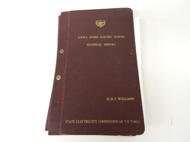 Kiewa Valley Historical Society
Book- History of SEC at Kiewa x2, Technical History of the Kiewa Hydro Scheme, circa 1960's
This book of planning and construction details covers the first detailed records the Kiewa Hydro Electricity Scheme of 1919 (ORIGINAL), 1958 (2nd Modified Plan) to the last general plan of 1961. It is an excellent overview of one of Australia's greatest construction projects (along with the Snowy River Hydro Scheme). This book highlights in detail the planning, programming and construction phases throughout the life of the construction from 1919 onwards until the 1960's. There were a few copies made using carbon paper and a type writer on foolscap paper.This book with its Parts A to D, photographs and plans/tables is very significant to the Kiewa Valley region as it details "the bones" of one of Australia's greatest construction projects that was undertaken by Governments that had the foresight and the will to undertake such a costly and environmentally imposing project for the benefit of their states and their country. This project was at a time when financial and security pressures where at a high and fluctuating level. This project was the major contributor to the expansion and diversity of non rural activities within the region. It was directly and indirectly the cause of better transportation avenues, tourism and the lifting of the regions natural facilities to sustain an ever increasing long term and short term population.This large hard (thick cover) book has both front and back sides fastened to the spine by two brass screw on pins. The book title, author/compiler and the commissioning organisation (STATE ELECTRICITY COMMISSION OF VICTORIA) together with the SEC Vic emblem are all embossed in gold script.The spine is also embossed with the title. The book contains 396 pages consisting of the 390 pages which are the duplicate(carbon copy) of the original type written pages and 6 pages of site plans. Sprinkled throughout the book are 36 original photographs of various stages of construction. There are also 17 sketches/plans scattered throughout and 22 tables.Title "KIEWA HYDRO ELECTRICITY SCHEME TECHNICAL HISTORY" author and compiler "H.H.C.WILLIAMS" below this "STATE ELECTRICITY COMMISSION OF VICTORIA"kiewa hydro electricity scheme, victorian state electricity commission, history, proposals, kiewa scheme's plans, book, h.h.c. williams -
University of Melbourne, Burnley Campus Archives
Plan, Caroline Le Souef, Plan of the Gardens of the Zoological and Acclimatisation Society of Victoria, Royal Park, melbourne, 1877
Appears to be based on the design by Alfred Lynch in 1861 see B17.0076. From ' Little Worlds: Australian Zoological Gardens Part III UWA. Also see B18.0029 Similar plan.Copy of plan from the 'Proceedings of the Zoological and Acclimatisation Society of Victoria, Vol 4, 1877. Drawn by Caroline Le Souef and reproduced in the early Melbourne Zoo guides.caroline le souef, alfred lynch, zoological and acclimatisation society of victoria, royal park, g. purchas -
 Musculoskeletal Health Australia (now held by the Glen Eira Historical Society)
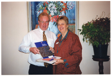
Photograph - Group photo, 19/10/1999
On the 19th of October, 1999, the Accessible Cities and Shires Forum was held in Bendigo. In this photo, Chris Stewart, City of Greater Dandenong Diversity Officer, and Shirley Caulfield, CEO of the Arthritis Foundation of Victoria, promote the Diversity Action Plan.COL photo of two people standing close to one another. They are each holding some publications, one of which is titled 'Diversity Action Plan'. [on label, in blue ink] Chris Stewart, City of Greater Dandenong Diversity Officer, and Shirley Caulfield, CEO of Arthritis Victoria at the Bendigo Accessible Communnities Forumshirley caulfield, ceo, arthritis foundation of victoria, afv, chris stewart, diversity officer, city of greater dandenong, accessible communities, diversity action plan, rural access project, accessible cities & shires project, forum, bendigo, 1999 -
 Federation University Historical Collection
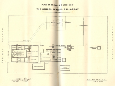
Booklet, Charles Boyd, The School of Mines Ballaarat Annual Report, 1882, 1882
The School of Mines Ballaarat Annual Report 24 January 1882, Additional Examination Statute, Certificates Granted by Council, Copy of letter received from the Honble. Francis Ormond MLC, Extracts from Visitors' Book, Fees, Form of Bequest, Life Governors, Museum open to Visitors, Office Bearers, Paper of Particulars, Report of the Curator of the Museum and Library (with plans), Report of the Superintendent of Laboratories, Report of the Lecturer in Telegraphy, Report of the Lecturer in Mechanical Engineering, Statement of Receipts and Expenditure for the year 1881, Subjects and Lecturers, Subjects and Examiners, Subscriptions and Donations from 1 January to 31 December 1881, The Lignite Deposit at Skipton (with Section and Plan)Ballarat School of Mines Annual Report. Pale brown booklet of 64 pages. A plan of the Ballarat School of Mines shows the position of the Botanical Gardens, and the Ballarat School of Mines Museum. Geological Sketch Map of Country in the Neighbourhood of Skipton and Plan showing site of Coal Discovery. Skipton Coal Discovery - Section of Windlass Shaft. .2) is a leatherbound copyballarat school of mines, coal, plan, ballarat school of mines botanical gardens, ballarat school of mines museum, museum, annual report, james oddie, w. p. bechervaise, s. e. friggis, f. j. martell, w. h. nicholls,, e. i. rosenblum, h. r. caselli, thomas mann, theos. williams, f. m. krause, alf. mica smith, walter d. campbell, w. h. shaw, charles kent, andw. berry, robert adam, wm. lant carpenter, henry parkinson, h. b. de la poer wall, w. h. brockenshire, arthur parker, c. davies, simon richards, c. r. blackett, david jones, wilberforce dyke, kr. r. krauel, duncan love, william ralph heaton, edward dowling, octavius vaughan morgan, william denton, e. h. grimwade, james hunter, the honble. francis ormond, ferdinand krause, a.a. buley, j. cosmo newberry, w.c. kernot, john lewis, j.m. bickett, james bickett, fees, annie barnett, annette budden, isabel clinton, john dimsey, agnes pobjoy, charlotte shaw, bernard o'dowd, bernard patrick o'dowd, josiah wasley, ferdinand von mueller, william kernot, john lynch, william henderson, henry richards caselli, w.p. berchervaise, e.i. rosenblum, w.h. nicholls, lignate, samuel figgis, mary drury, w. longley, botanical reserve, botanical gardens, francis ormond, george russell, william foster stawell, w.j. clarke, rivett henry bland, john warrington rogers, j. lonie, s.e. figgis, r.f. hudson, w. robertson, e.l. rosenblum, theophilus williams, andrew berry, henry sutton, h. rosales, state school classes, calcutta international exhibition, examinations, h.b.m ship bounty, certicates, walter charles kernot, william tunbridge, mary skelton, cartherine moran, mary rose usher, margaret ellen brophy, william burbridge, andrea tuxen, elizabeth curnow, francis campigi, james s. morrison, arthur hogue -
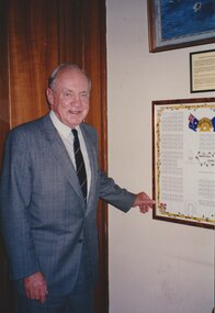 Melbourne Legacy
Photograph, President Stevenson with a diagram of Harefield Cemetery, 1993
Photo of Legatee John Stevenson, he was President in 1993. He is standing next to a mounted poster showing a plan of the graves at Harefield ANZAC Cemetery in the UK. More details of the cemetery in another record. Not sure if the poster once hung at Melbourne Legacy or if it was elsewhere. The photo was stored with other photos of an event at Northcote RSL.A photo of a past president.Photo of Legatee John Stevenson, standing next to a mounted poster showing a plan of the graves at Harefield ANZAC Cemetery in the UK.cemetery, john stevenson, harefield -
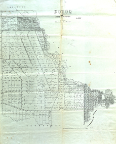 Federation University Historical Collection
Map, Doroq County of Grenville L4935, 1911, 28 June 1911
This plan is associated with former Ballarat School of Mines Student Richard Squire (1875-1876). Gift of the Squire FamilyParish Plan of Doroq in black ink printed on cream paper. It includes the township of Inverleigh and Barwon Rover. Some of the names on the plan are William McRobie, William MacRobie, Thomas Russell, W.C. Smith, John Bell, J. Moffatt, Thomas Moffatt, John Anderson, George Synnot, Charles Lloyd, William MacRobie, J. Flack, Alexander Campell, T. Maher, William Berthon. Thomas Jewell, James Carstairs, D. MCInnerney, F.H. Holland, Robert Morrison17 7/9 18 9 miles handwritten in pencil Photo lithographed at the Department of Lands and Survey Melbourne by T. E. McGauran 28.6.11 Price 1/-carrunge-murnong, murdeduke, carrah, shelford, inverleigh, barwon river, hesse, wingeel, george russell, george russell's pre-emptive section, john moffatt, w. c. smith, macrobie, john bell, thomas russell, t.f. mcgauran -
 Kew Historical Society Inc
Plan, Melbourne & Metropolitan Board of Works : Contour Plan of Melbourne & Suburbs : Melbourne Sewage, 1894
The Melbourne and Metropolitan Board of Works (MMBW) plans were produced from the 1890s to the 1950s. They were crucial to the design and development of Melbourne's sewerage and drainage system. This plan forms part of a large group of MMBW plans and maps that was donated to the Society by the Mr Poulter, City Engineer of the City of Kew in 1989. Within this collection, thirty-five hand-coloured plans, backed with linen, are of statewide significance as they include annotations that provide details of construction materials used in buildings in the first decade of the 20th century as well as additional information about land ownership and usage. The copies in the Public Record Office Victoria and the State Library of Victoria are monochrome versions which do not denote building materials so that the maps in this collection are invaluable and unique tools for researchers and heritage consultants. A number of the plans are not held in the collection of the State Library of Victoria so they have the additional attribute of rarity.Digital copy of an original MMBW plan. This contour plan shows the area identified by the MMBW for purposes of drainage and sewerage in 1894. The suburbs represented extend from Williamstown in the west to Bulleen in the east, and from Preston in the north, south to Sandringham. Suburbs are outlined in coloured ink. Red lines indicate main and branch sewers in existence at the beginning of 1894 in central and inner Melbourne. These extended as far as Williamstown and Brighton, but not yet as far as Kew, where sewering did not commence until 1901. Contour lines show the topography, which was important for indicating the fall of the land for the laying of sewers and drainage channels. Kew appears to be fairly undeveloped at this date except for railway lines and stations (the Kew and Outer Circle lines), main roads, the Kew Lunatic Asylum Reserve and Studley Park. However, the contour plan does not accurately represent the density of settlement, nor the large number of houses, which were being built in Kew and other suburbs from the 1850s to the land boom of the late 1880’s and early 1890’s. This plan is part of a large and historically significant group of MMBW plans and maps that was donated to the Society by the Mr Poulter, City Engineer of the City of Kew in 1989.mmbw contour plan of melbourne and suburbs, melbourne and metropolitan board of works, melbourne sewage, cartography -
 Bendigo Historical Society Inc.
Document - MARKS COLLECTION: PLAN FORTUNA HOT WATER HEATING
Copy of plan: plan shows floor plan and design plans for hot water heating system to be installed in Fortuna Villa. Plans of basement and first floor. Heating unit construction detailed on plan. As plan has been copied, the stamp of the architect is indecipherable.buildings, house, fortuna villa -
 Warrnambool and District Historical Society Inc.
Book, Warrnambool Botanic Garden Masterplan, February 1995
This Warrnambool Botanic Gardens Study and Report was funded by the National Estate Grants Program of the Australian Heritage Commission and the City of Warrnambool. It was monitored in progress by a Steering Committee consisting of representatives of the Botanic and Public Gardens Advisory Committee, the Warrnambool City Council, Friends of the Warrnambool Botanic Gardens and National Estate Grants Program representatives and community representatives. The Warrnambool Botanic Gardens were first sited close to the Hopkins River in 1859. In 1869 the gardens were relocated to the present day location in Botanic Road. This plan is of some importance as it gives an overview of the history and current condition in 1995 of the Warrnambool Botanic Gardens and draws up a plan for its future development. It is useful for research and for consideration by the City Council today of policy making and further development of the gardens. This is a publication containing a master plan for the Warrnambool Botanic Gardens. It has a section on acknowledgements, a summary, eight chapters, and 14 appendices. The pages are bound with plastic rings, the front cover is plasticized with an aerial photograph of the Botanic Gardens and surrounds and the back cover is lightweight cardboard. The pages contain printed material, fold out maps, sketches and diagrams and many photocopied photographs.Front Cover: City of Warrnambool, Warrnambool Botanic Gardens, Conservation and Development Plan, Jill Orr-Young, Patrick Mallon, SF Consultants Pty Ltd, February 1995. warrnambool botanic gardens, warrnambool -
Port Melbourne Historical & Preservation Society
Plan - Port Melbourne Town Hall, Engineering Department, Town of Port Melbourne, 1915
Plan of new (1915) Town Hall, Port Melbourne Foundation Plan, ground floor plan; first floor planport melbourne town hall -
 Kew Historical Society Inc
Photograph - 8 roomed DF Brick Villa, Kew, J E Barnes, c.1920
Subdivision plans are historically important documents used as evidence of the growth of suburbs in Australia. They frequently provide information about when the land was sold on which a built structure was subsequently constructed as well as evidence relating to surveyors and real estate and financial agents. The numerous subdivision plans in the Kew Historical Society's collection represent working documents, ranging from the initial sketches made in planning a subdivision to printed plans on which auctioneers or agents listed the prices for which individual lots were sold. In a number of cases, the reverse of a subdivision plan in the collection includes a photograph of a house that was also for sale by the agent. These photographs provide significant heritage information relating house design and decoration, fencing and household gardens. The photograph is of additional aesthetic significance as it was photographed by J. E. Barnes. Josiah Earl Barnes is a nationally significant photographer. He was also the most important photographer to have worked in Kew. He was active as a photographer in the district from c.1906 until his death in 1921. Best known as 'the Embarkation Photographer' (see the Australian War Memorial collection), J. Earl Barnes was also the official photographer employed by the Borough (and later Town, then City) of Kew. He clearly also completed commercial jobs for local businesses, as is the case in this photograph of a house for a local real estate and financial agent.A photograph, mounted on board of a double fronted Federation-era brick villa in Kew, photographed for a local real estate agent and financier by J. E. Barnes of Kew. On the reverse of the photograph is a subdivision plan for the Normanby Estate, East Kew - 2016.0039.1. As can be seen from the image, there is a large tear on the surface of the photograph.The brown card on which the photograph is mounted includes the following handwritten description, which may aid the identification of the house: "Kew, 3 minutes from tram, 8 roomed DF Brick Villa, tile roof including two attics, sleepout, bathroom, heater, E Light, Entrance Hall, double doors, leadlights, laundry, garden, lawns, land 75 x 170, 1975 pounds". Also photographers inscription on mount, lower left: J. E. Barnes / Photo / Phone 1966 Haw. KEW.j. e. barnes, josiah earl barnes, j. earl banes - photographer, architecture - federation style, houses - kew, real estate photographs -
 Kew Historical Society Inc
Plan - Subdivision Plan, Auburn Heights Estate, 1921
The Kew Historical Society collection includes almost 100 subdivision plans pertaining to suburbs of the City of Melbourne. Most of these are of Kew, Kew East or Studley Park, although a smaller number are plans of Camberwell, Deepdene, Balwyn and Hawthorn. It is believed that the majority of the plans were gifted to the Society by persons connected with the real estate firm - J. R. Mathers and McMillan, 136 Cotham Road, Kew. The Plans in the collection are rarely in pristine form, being working plans on which the agent would write notes and record lots sold and the prices of these. The subdivision plans are historically significant examples of the growth of urban Melbourne from the beginning of the 20th Century up until the 1980s. A number of the plans are double-sided and often include a photograph on the reverse. A number of the latter are by noted photographers such as J.E. Barnes.The name ‘Auburn Heights Estate’, was handwritten on the subdivision plan, and included 23 lots in Auburn Road and Wright and View Streets, Hawthorn. Most of the houses built on the lots that were sold still exist. The house built on number 8 View Street is a contemporary exception. The subdivision included an existing home at number 17 View Street.subdivision plans - hawthorn, auburn heights estate -
 Kew Historical Society Inc
Plan, Melbourne & Metropolitan Board of Works : Borough of Kew : Detail Plan No.1569, 1905
The Melbourne and Metropolitan Board of Works (MMBW) plans were produced from the 1890s to the 1950s. They were crucial to the design and development of Melbourne's sewerage and drainage system. The plans, at a scale of 40 feet to 1 inch (1:480), provide a detailed historical record of Melbourne streetscapes and environmental features. Each plan covers one or two street blocks (roughly six streets), showing details of buildings, including garden layouts and ownership boundaries, and features such as laneways, drains, bridges, parks, municipal boundaries and other prominent landmarks as they existed at the time each plan was produced. (Source: State Library of Victoria)This plan forms part of a large group of MMBW plans and maps that was donated to the Society by the Mr Poulter, City Engineer of the City of Kew in 1989. Within this collection, thirty-five hand-coloured plans, backed with linen, are of statewide significance as they include annotations that provide details of construction materials used in buildings in the first decade of the 20th century as well as additional information about land ownership and usage. The copies in the Public Record Office Victoria and the State Library of Victoria are monochrome versions which do not denote building materials so that the maps in this collection are invaluable and unique tools for researchers and heritage consultants. A number of the plans are not held in the collection of the State Library of Victoria so they have the additional attribute of rarity.Original survey plan, issued by the MMBW to a contractor with responsibility for constructing sewers in the area identified on the plan within the Borough of Kew. The plan was at some stage hand-coloured, possibly by the contractor, but more likely by officers working in the Engineering Department of the Borough and later Town, then City of Kew. The hand-coloured sections of buildings on the plan were used to denote masonry or brick constructions (pink), weatherboard constructions (yellow), and public buildings (grey). This plan covers parts of Sackville Street, John Street, Thomas Street and Cotham Road, and includes several very large houses in Sackville Street. Job Smith built ‘Berrington’ in about 1888-90 for himself, and ‘Pomeroy’ (now ‘Merridale’) in 1885 for James Mickleburgh. ‘Heathfield’ was built in 1888 for Henry Eeles, and was one of many fine homes in Kew, Hawthorn and surrounding suburbs designed by prolific architect John Beswicke; it later became “La Verna” and was a Franciscan monastery. Similarly, in Cotham Road, we can see ‘Bella Vista’ (now demolished), and ‘Charleville’, with its double-storeyed arcade frontage, built in 1889 for Charles Donaldson whose family occupied it until 1939. This was renamed ‘Ross House’ by the second owner, Dr. Thomas King, and then substantially restored in the 1960s by the Stillwell family, well known as car drivers and dealers. Bella Vista (later ‘Malinda’) was originally designed by the architect Robert Haddon and built for Abel Hoadley, inventor of the Violet Crumble Bar and many other delicious delicacies. He began by manufacturing jams and pickles in South Melbourne using fruit from his own orchard in East Burwood.melbourne and metropolitan board of works, detail plans, mmbw 1569, cartography -
Whitehorse Historical Society Inc.
Pamphlet, Public Meeting, 1/04/1944 12:00:00 AM
Copy of brochure prepared by Blackburn Community Welfare CommitteeCopy of brochure prepared by Blackburn Community Welfare Committee for a public meeting about a proposal concerning the health and recreation of babies, children, youth and adults. Planning Baby Health and Community Welfare Centre.Copy of brochure prepared by Blackburn Community Welfare Committee community services, blackburn community welfare committee, armstrong, norman, morton hall, blackburn progress association -
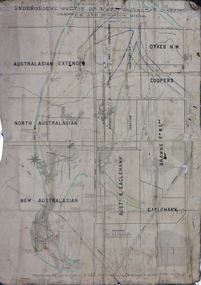 Federation University Historical Collection
Plan, Underground Survey of Mines, Ballarat District, Creswick and Kingston Mines, 1888, 06/1888
This plan is associated with former Ballarat School of Mines Student Richard Squire (1875-1876). Gift of the Squire FamilyA paper plan on linen showing the following mines: Australasian Extended, North Australasian, Davis and Charlesons Amalgamated, Davies Junction, Dykes N.W., Coopers, F & L Holding, New Australasian, Australasian and Eaglehawk, BrawnsWritten above Australian Extended "West Berry Consols Coy" Written near Davis' and Charlesons Amalgamated "West Berry Consols Coy"creswick, kingston, berry, australasian, plan, mining, robert allen, richard squire -
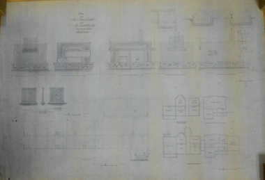
 Federation University Historical Collection
Plan - Plan (copy), 'Brick cased Residence 1515 Sturt Street West for Mrs H.L. Coburn, by H. Leslie Coburn, not dated
Ballarat born Herbert L. Coburn grew up to be a renowned Ballarat architect, practising from 1905 to 1956. He taught Architecture and Building Construction at the Ballarat School of Mines (SMB) from 1918, resigning in 1948 due to ill health.Copy of a plan by H.L. Coburn. It includes a front, west, east and rear elevation; ground plan, block plan; and layout plan. herbert l. coburn, h.l. coburn, coburn, architecture, herbert coburn, architectural plan -
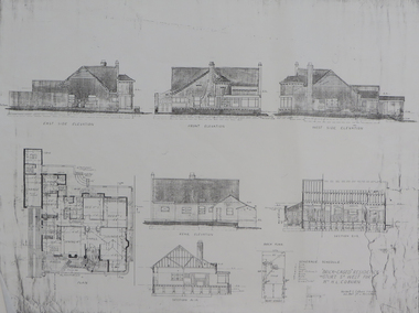
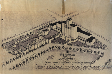 Federation University Historical Collection
Plan, Ballarat School of Mines Future Development: A Southern Terminal to Lydiard Street, 1947, 09/12/1947
In 1947 Percy Everett, Chief Architect for the Victorian Government, drew up plans to accomodate the growth in student numbers on the Ballarat School of Mines site. It was an era of government buildings surrounding the Ballarat School of Mines campus either being transfered to the school or foreshadowed for transfer. In 1947 two Red Cross huts were transferred from Victoria Park to the western side of the former Ballarat Supreme Court (later Courthouse Theatre) for use by Wool Classing and Motor Mechanics. In the same year additional facilities were provided for Pottery due to the increase in enrolments and a large brick classroom was built at the rear of the Ballarat Junior Technical School Building. In the annual report of 1947 the President said: "These transfers are, however, only temporary expedients and indicate the pressing need for more buildings of a permanent nature". By the end of the year the School Council decided to request the Education Department of Victoria to proceed with the implementation of the School's long-range plan whch had received approval earlier and to treat it as an urgent post-war requirement. After much communication a plan for a six-storied building, flanked by two three storied buildings was planned to be built on the site of the Ballarat Gaol was developed. The plan was sent to the Education Department for the Minister's Approval. It is not know if approval was granted, but the building did not proceed, possibly becausse the Ballarat Gaol was still very miuch in use. When a tertiary division of the Ballarat School of Mines was being developed in 1967 it corresponded with the closure of the Ballarat Gaol. It was determined that the Lydiard Street South site had no room for future growth so a new campus was sought. The new campus was purchased at Mt Helen, and was initially known as the Ballarat Insittute of Advanced Education. In 1976, when the Ballarat Teachers' College merged into the structure, the campus became known as the Ballarat College of Advanced Education and it was no longer a part of the Ballarat School of Mines. Plans for a proposed building to replace the Ballarat Gaol buildings. The proposed building was never built, the concept being replaced by a new teritary facility at Mt Helen. buildings, percy everett, ballarat school of mines battery, ballarat technical art school, engineering workshops, machine shop, ballarat junior technical school, architectural plans, ballarat school of mines, smb campus -
University of Melbourne, Burnley Campus Archives
Plan - Photocopy, Site for New Building Burnley S. of H, 1961?
Photocopy of Public Works Department Site for New Building UCB.2.110 Part of 61/590. Handwritten on it, " Plans were drawn up for a new building on right of Swan Street driveway - Public Records Office has plan of this building."buildings, victoria. public works department, burnley school of horticulture -
Whitehorse Historical Society Inc.
Document, Australian Social History House Research Assignment, 1986
Social History of 2 Gordon Crescent, Blackburn,Social History of 2 Gordon Crescent, Blackburn, included - History of Blackburn, Architecture of the House and first owner, Thomas Richards Burrowes. Morton. Real Estate Brochures, Maps, Photos, Floor Plans.Social History of 2 Gordon Crescent, Blackburn, morton thomas richards burrowes, architecture -
 Lakes Entrance Historical Society
Photograph - proposed plan for Art and Drama Centre, Lakes Post Newspaper, 1/07/1994 12:00:00 AM
members of Art Workshop Stan Langtip Lois Dilks and Jill Langtip with proposed plan for Art and Drama Centre and lost in the amalgomation of the Shires Lakes Entrance VictoriaBlack and white photograph of members of Art Workshop Stan Langtip Lois Dilks and Jill Langtip with proposed plan for Art and Drama Centre and lost in the amalgomation of the Shires Lakes Entrance Victoriaarts, exhibition, fundraising