Showing 6754 items matching "rivers"
-
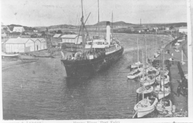 Port Fairy Historical Society Museum and Archives
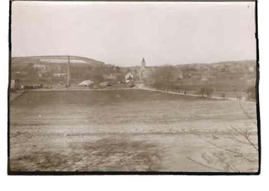
Photograph, 1905
B&W Photograph Iron Steamship SS Casino in the Moyne Rivership, boat, sea, river, iron steamship ss casino -
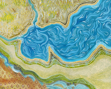 City of Greater Geelong
Painting - Acrylic on Canvas, Dr Jenny Murray-Jones, Corio, 2019
This work is all about Country for Wadawurrung people, the lay of the land, food crops and the abundant recourses which sustains the Wadawurrung people. Again I have used traditional patterns and made reference to Wallaby Grass and Murnong staple foods for Wadawurrung people.Painting of river and grassland from above. Green, blue and brown used.On back left bottom corner - J.Murray.Jones 2019 'Corio'corio, wadawurrung, murnong -
 Lakes Entrance Historical Society
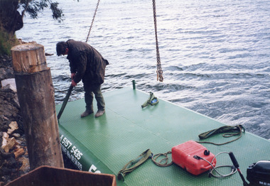
Photograph - Barges, Lakes Post Newspaper, 1999
Photo and article appeared in the Lakes Post Newspaper 28 July 1999|Barge was built by Wayne Smith for the firm East Gippsland Bridges.|Also two other photographs similarColour photograph of the launching of a new work barge in the Tambo River, Victoria.boats and boating, waterways, barges -
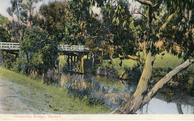 Stawell Historical Society Inc
Postcard, Bridge at Glenorchy -- Postcard -- Coloured
Coloured postcard of Bridge at Glenorchy.Coloured Post card of a timber bridge over a river in bush settings.On Front Glenorchy Bridge, Stawell On Reverse Printed in Germany 155/81467 Post Card This Space May be used for Correspondence. This for Address Only.water -
 Bendigo Historical Society Inc.
Photograph - ROBERT DENIS KELLY COLLECTION: RIVER WITH BRIDGE
Black and white photo: river with bridge overhead. On back of photo 'Gamaches'?person, robert denis kelly, world war 1, france, bridge, manteuge -
 Lakes Entrance Historical Society
Postcard - Battans Landing, W R Lidston Bairnsdale, 1900 c
Colour postcard of Battans Landing on Tambo River at Tambo Upper Victoriajetties, waterways, boats and boating -
 Lakes Entrance Historical Society
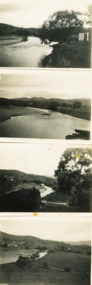
Photograph - Buchan River, M D Fish, 1/09/1933 12:00:00 AM
Permission required from LERHS for copyingBlack and white photographs of Buchan River below the bridge, Buchan Victoriawaterways, topography -
 Lakes Entrance Historical Society
Photograph - Tambo River along Omeo Highway
Black and white photographs of Tambo River along the Omeo Highway Victoriawaterways, roads and streets -
 Federation University Historical Collection
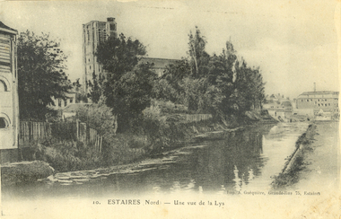
Postcard - black and white, Estaires, France, c1917, C1917
WW1 Australian soldier Holmes Famiiy memento. Estaires is a town and commune in the Department of the Nord, about 11 kilometres west of Armentieres. The Estaires Communal Cemetery and Extension is on the eastern outskirts of the town and on the east side of the road to Bailleul. Estaires town was occupied by French cavalry on the 15 October 1914, and passed at once into British hands. On the 10 April 1918 it was captured by the enemy, after an obstinate defence by the 50th (Northumbrian) Division; and it was finally retaken by British troops at the beginning of September 1918. The town was a Field Ambulance centre as early as November 1914, and later the 1st Australian Casualty Clearing Station was posted in it. (http://www.cwgc.org/find-a-cemetery/cemetery/26801/ESTAIRES%20COMMUNAL%20CEMETERY%20AND%20EXTENSION, accessed 11/07/2014)Australian soldier's WW1souvenirA black and white postcard with buildings along a river at Estaires in Northern France.estaires communal cemetery and extension, estaires, france, chatham-holmes family collection, 1st australian casualty clearing station, postcard -
 Kew Historical Society Inc
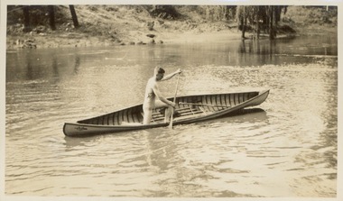
Photograph - Victorian Canoe Club, Racer completed (Retriever), 1920-30
Canoeing on the River Yarra at Melbourne was an important and widespread recreational pursuit for Melbournians, especially in the first half of the twentieth century. The Victorian Canoe Club was formed in 1912 at a meeting in Melbourne and its first committee elected in the same year. Records indicate that the Club continued into at least the 1950s .The album has historic and social significance as a record of recreational activities (as well as canoe making) in the early years of the twentieth century. It has local significance as the site of the headquarters of the Club was in Studley park. A number of photographs in the album provide vistas of Kew on the Yarra that are otherwise unavailable.One of 24 labelled photos in part album, originating from the Victorian Canoe Club, which had its headquarters in Studley Park, Kew. The album includes a photographic record of canoe construction and also locations in Studley Park and Kew where the canoes were used. The subject of this photograph is identified as 'Racer completed (Retriever)' where the completed canoe is trialled on the Yarra River."Racer completed (Retriever)"victorian canoe club, canoe making, river yarra, burke road, mornington, studley park, kew, steaming gear, canoe construction -
 Federation University Historical Collection
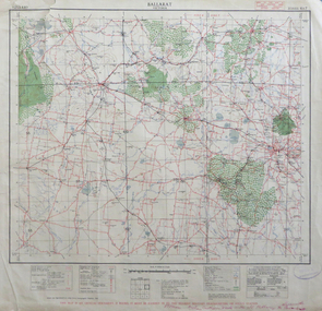
Map, Ballarat, Victoria, 1942, 1942
Two copies of a map of the district around Ballarat, including Creswick, Scarsdale, Smythesdale, Lake Bolac, Ararat, Talbot, Sebastopol, Maryborough, Cardigan, Skipton, Mount Emu Creek, Leigh River, Fiery Creek, Hopkins River. Street names are listed on the back of the map. It includes roads, timber, creeks, rivers, telephone lines, railwayPrinted in red at the base of the map "This map is an official document. If found, itmust be handed in to the nearest Military Headquarters or Police Station.ballarat, map, world war two, skipton, creswick, ararat, lake bolac -
 Bendigo Historical Society Inc.
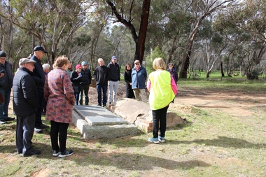
Bendigo Historical Society Walking Tour of Axedale, 1st Sept 2024
Axedale is a town in Victoria, Australia. It is located on the McIvor Highway, in the City of Greater Bendigo, east of Bendigo. It was surveyed and proclaimed in 1861. At the 2021 census, Axedale had a population of 984. The town is nestled alongside the Campaspe River which feeds out of Lake Eppalock. It has a golf course, tennis courts, a school, a pub and a convenience store/petrol station. It lies between Heathcote and Bendigo.Forty Photos taken on the walking tour of Axedale by the Bendigo Historical society. Places visited included the Protestant and Catholic Cemeteries, the "Blue Stone House", the 150-year-old bridge over the Axe Creek on the Sugerloaf Road, the old Cobb and Co Stables, St Andrews Church and the Campaspe River Bridge.axedale, bendigo historical society walking tour, st andrews church axedale, axedale cemetery, axe creek bridge, campaspe, cobb and co stables axedale, blue stone house axedale -
 Kew Historical Society Inc
Photograph - Macauley's, Kew, 1924
Henry Beater Christian (1886-1962) , was a descendant of one of the earliest settler families in Kew. Employed at the Kew Asylum as a 'public servant', he was a skilled amateur photographer, photographing numerous scenes in Kew and on his travels around Victoria. The majority of his photographs date from 1916 to 1929. His finest photographs are housed in two photograph albums. A fine, early view of Macauley's boat sheds on the Yarra River at Kew.Digital copy of a photograph from page 2 of the 47-page photograph album containing 261 gelatinous silver images, loaned by Diane Washfold with permission given to digitise and hold a copy in our collection. The photograph is of Macauley's boat sheds on the Yarra River at Kew. The boat sheds were located at the west end of Molesworth Street. The photograph is taken from the Yarra Bend Park side of the river, or from a boat on the river. The canoes belonging to Macauley's are lined up on the river bank. "Macauley’s Kew"henry beater christian (1886-1962), landscape photography, kew (vic.) — yarra river, christian-washfold collection, photograph albums, macauley's boat sheds -
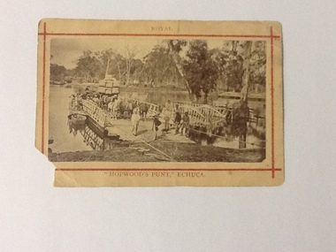 Port of Echuca
Photograph (sepia), approx 1850's
Sepia photograph of Hopwood's Punt, showing the gangway extended to river bank. There are 5 workmen, dressed in work clothes and boots, at the front of the punt and 2 gentlemen, dressed in coats and umbrellas. Stock, produce (possibly wool bales) and people are on board. There are 3 horses hitched to a wagon and behind there looks like a large consignment of wool bales. There appears to be women at the side of the punt (1 with an umbrella up). At the side of the punt there appears to be a passenger landing. There is also a small row boat tied to the side of the punt. Wagons, barge and possibly other punts are in the background. There was a painting of this scene by J. C. Armytage around 1857.This is a very good example of the cargo, people, produce and animals, that were using the punt to cross the Murray river in the late 1800s. The difference between workers and gentry can be seen as well as the modes of transport at this time.Sepia photograph of Hopwood's Punt, showing the gangway extended to river bank. Stock, produce (possibly wool bales) and people are on board. Wagons, barge and possibly other punts are in the background. Mounted on buff cardboard printed with red lines and letters.On the front at the top, above the red boarder "Royal", at the bottom below the red boarder "Hopwood's Punt, Echuca". On the reverse, "W. B. Payne, Darling St., Echuca"murray river, echuca, hopwood's punt, j. c. armytage (painter) -
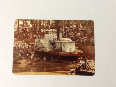 Port of Echuca
Colour Photograph, 04/03/1983
This coloured photograph shows the re-floating of the P. S. Adelaide on a soil ramp, being encouraged (rear entry) down the temporary slipway onto the river. The temporary slipway is clearly visible with a workman (possibly Kevin Hutchinson) standing at thelast log as the boat nears the waters' edge. A winching float and an outboard motor boat are at the right. Spectators line the banks of the ramp. Part of a photo sequence no.P000041; P000045; P000046; P000047; P000048 of P. S. Adelaide re-floating.The re-floating of the P. S. Adelaide was a Significant community social event evident by the number of spectators in the photograph. The community had invested a great deal of time and money into re-floating the paddlesteamer. The newspaper covered the event in detail with a number of action shots as the boat made its rear entry from the temporary slipway onto the river. Part of a photo sequence no.P000041; P000045; P000046; P000047; P000048 of P. S. Adelaide re-floating.Colour photograph of the P. S. Adelaide on a soil ramp, being encouraged (rear entry) onto the river. A winching float and an outboard motor boat are at the right front. Spectators line the banks of the ramp. Temporary slipway constructed of logs is clearly visible before the boat enters the water. -
 Kew Historical Society Inc
Photograph - Flooding of the Yarra River in North Kew, 1934
North Kew, now divided between Kew and Kew East, bordered the Yarra River. As such, it was a region subject to flooding in the Yarra Valley. Development beyond this point (ie Kellett Grove) was limited by the City of Kew's planning regulations. Prior to urban development, the area since European settlement and the first land sales in the district in the 1840s, had been used for dairy farming. Small sepia snapshot of floodwaters taken from near Willsmere Road, in what was then known as North Kew. The point of view is looking towards Fairfield. In the foreground are two figures viewing a group in a rowboat in the middle of the flooded river. Semi-submerged street lighting indicates that entire streets had been. overwhelmed by the flood waters. Verso: WILLSMERE ROAD NORTH KEW / Stamped 3 163yarra river -- north kew, floods -- yarra valley, floods -- north kew, floods -- 1934, natural disasters -- kew, willsmere road -
 Kew Historical Society Inc
Photograph - Victorian Canoe Club, Nagha & Dunapna completed completed, 1920-30
Canoeing on the River Yarra at Melbourne was an important and widespread recreational pursuit for Melbournians, especially in the first half of the twentieth century. The Victorian Canoe Club was formed in 1912 at a meeting in Melbourne and its first committee elected in the same year. Records indicate that the Club continued into at least the 1950s .The album has historic and social significance as a record of recreational activities (as well as canoe making) in the early years of the twentieth century. It has local significance as the site of the headquarters of the Club was in Studley park. A number of photographs in the album provide vistas of Kew on the Yarra that are otherwise unavailable.One of 24 labelled photos in part album, originating from the Victorian Canoe Club, which had its headquarters in Studley Park, Kew. The album includes a photographic record of canoe construction and also locations in Studley Park and Kew where the canoes were used. The subject of this photograph is identified as 'Nagha & Dunapna completed' with an overhead view of two named canoes on the banks of the Yarra River."Nagha & Dunapna completed"victorian canoe club, canoe making, river yarra, burke road, mornington, studley park, kew, steaming gear, canoe construction -
 Glenelg Shire Council Cultural Collection
Print - Contact Print - Pastoral Scene, 1960-1970
Sheet of 2 contact prints from glass plate negatives. Top: 2 men and 2 women in a clinker built dinghy on a river. Beds of reeds in river. River bank heavily wooded. Bottom: 3 women, one seated in garden at 'Beechwood', Dutton Way. People in both prints dressed in fashion late 19th, early 20th century. -
 Kew Historical Society Inc
Photograph - Flooding of the Yarra Valley at Kew East, 1974
Flooding of the Yarra Valley, including that section of the Yarra bordering Kew and Kew East in the north and west of the municipality, was a regular occurrence. Extreme flood events of the Yarra River are recorded to have occurred in 1891, 1901, 1916, 1923 and 1934. The Municipality of Kew's response to these floods was to enact planning decisions restricting residential development in flood prone areas following the floods of 1916, 1921 and 1934. While floods continued after the development of the Upper Yarra Reservoir (construction 1948-57), the regularity and extent of these inundations diminished. During the nineteenth century, the land abutting the south side of the Yarra in Kew was devoted to dairy farming. In the twentieth century, before and after the construction of the Eastern Freeway, much of this low-lying area was used as golf courses and public parks.Late example of the capacity of the Yarra Valley at Kew to flood, even though drainage works and the Upper Yarra Reservoir had reduced their regularity.Original black and white print photograph of Hay's Paddock under floodwater on 16 May 1974. The vantage point of the photographer is Keystone Crescent looking east. Flooding was caused by overflowing water in Glass' Creek and the River Yarra. Annotation verso: "Keystone Cr looking east / 16 May 1974 11.50am"hays paddock, floods, yarra river, glass' creek -
 National Wool Museum
Photograph, Yarra Falls: Yarra River in Flood
James Murgatroyd worked at Warrnambool Woollen Mills, Federal Mill, Tweedside, Collins Mills and set up looms for Alexander Spinning Mills Sydney, his son Fred Murgatroyd worked as a loom tuner at Yarra Falls, Tweedside and Collins mills in Victoria as well as in Sydney, and studied at Leeds University.Murgatroyd Photograph CollectionF Murgatroyd Yarra Falls: Yarra River in Flood KODAK PRINTtextile machinery textile mills textile mills, yarra falls mill, murgatroyd, mr fred murgatroyd, mr james, textile machinery, textile mills -
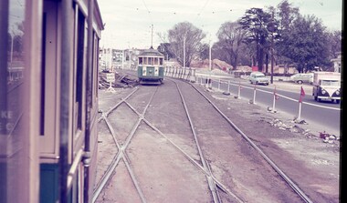 Melbourne Tram Museum
Slide - Set of 3, Keith Caldwell, March 1967?
Set of three Agfa colour blue white plastic mount slides, photo by Keith Caldwell of : .1 - W2 651 outbound on route 15 to St Kilda beach negotiating trackwork at the St Kilda Junction. .2 - view from Upton Road overpass looking east at the Queensway road and tram track construction .3 - ditto, looking west shows the St Kilda Road bridge section being constructed c early, possibly March 1967.1 - "BXBU" and on .3, .1 also has "MBR River" in ink.trams, tramways, st kilda rd, st kilda junction, w2 class, route 15, trackwork, queensway, tram 651 -
 Kew Historical Society Inc
Photograph - Construction of the Eastern Freeway (F19), Ron Setford, March 1972
Ron Setford and his wife Grace Setford lived in Tanner Avenue, East Kew, from c.1946 to c.1995. A keen photographer, he recorded the changing face of Kew over a 20 year period. Apart from 30 photographs of built structures and places in Kew dating from 1960 and 1961, 145 of his 35mm colour slides chronicle the development of the F19 (later renamed Eastern) Freeway through the Yarra Valley in Kew over a five year period from c.1972 to c.1977. This important collection was donated to the Society by his granddaughter in 2025.This collection of 175 35mm slides is of local and statewide significance, owing to its subject matter, particularly the major development of road transport infrastructure during the 1970s with the construction of the Eastern Freeway. The photographer also took care to annotate and date most of his slides which enable the researcher to pinpoint temporal and spatial locations."Eastern Freeway 6/72 / Rock fill in old river bed"ron setford, eastern freeway, f19 freeway -
![Photograph - Construction of the F19 [Eastern Freeway], Ron Setford, ca. 1973](/media/collectors/550653872162f11fb04854aa/items/6804bf9ce716c23079f56c8e/item-media/6804bfc2e716c23079f56eab/item-fit-380x285.jpg) Kew Historical Society Inc
Kew Historical Society IncPhotograph - Construction of the F19 [Eastern Freeway], Ron Setford, ca. 1973
Ron Setford and his wife Grace Setford lived in Tanner Avenue, East Kew, from c.1946 to c.1995. A keen photographer, he recorded the changing face of Kew over a 20 year period. Apart from 30 photographs of built structures and places in Kew dating from 1960 and 1961, 145 of his 35mm colour slides chronicle the development of the F19 (later renamed Eastern) Freeway through the Yarra Valley in Kew over a five year period from c.1972 to c.1977. This important collection was donated to the Society by his granddaughter in 2025.This collection of 175 35mm slides is of local and statewide significance, owing to its subject matter, particularly the major development of road transport infrastructure during the 1970s with the construction of the Eastern Freeway. The photographer also took care to annotate and date most of his slides which enable the researcher to pinpoint temporal and spatial locations."Eastern Freeway / Bridge over river Fairfield - Kew / Hornibrook contractor"ron setford, eastern freeway, f19 freeway -
 Kew Historical Society Inc
Photograph - Construction of the F19 [Eastern Freeway], Ron Setford, ca. 1973
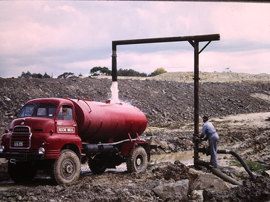
Ron Setford and his wife Grace Setford lived in Tanner Avenue, East Kew, from c.1946 to c.1995. A keen photographer, he recorded the changing face of Kew over a 20 year period. Apart from 30 photographs of built structures and places in Kew dating from 1960 and 1961, 145 of his 35mm colour slides chronicle the development of the F19 (later renamed Eastern) Freeway through the Yarra Valley in Kew over a five year period from c.1972 to c.1977. This important collection was donated to the Society by his granddaughter in 2025.This collection of 175 35mm slides is of local and statewide significance, owing to its subject matter, particularly the major development of road transport infrastructure during the 1970s with the construction of the Eastern Freeway. The photographer also took care to annotate and date most of his slides which enable the researcher to pinpoint temporal and spatial locations."Eastern Freeway / Filling water tanker from river / 5/73"ron setford, eastern freeway, f19 freeway -
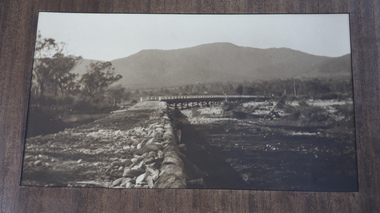
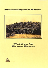 Ringwood and District Historical Society
Book, Bruce Bence, Warrandyte's River, C. 1986
Historical information provided by state water, road, and metrological and local government authorities and local residents' reminicences of the Yarra River at Warrandyte. Includes table showing periodic significant flows of the river between 1863 and 1985. -
 Kiewa Valley Historical Society
Photos - Tawonga Bridge x 2
The first Tawonga bridge was built in 1884. It was destroyed by floods in 1916. The new bridge was constructed in 1923 and destroyed in 1953. The present concrete bridge was constructed in 1986 and named Ryders Bridge. Also refer to ?KVHS 0962 and KVHS 1051, KVHS 1090, KVHS 1123Bridge constructed over the Kiewa River in 1923 and destroyed in 1953.1. Dark Brownish photo framed by thin wood. Photo shows bridge with mountain behind and river and river bank in the foreground. 2. Small photo showing 2 sides of the bridge - a close up view.tawonga bridge, kiewa valley, kiewa river -
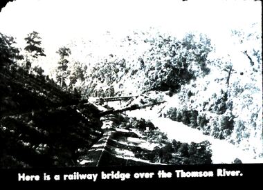 Bendigo Historical Society Inc.
Slide - DIGGERS & MINING. DIGGERS AND MINERS, c1850s
Diggers & Mining. Diggers and miners. Walhalla - Gold Town. Here is a railway bridge over the Thomas River. Picture shows the lush growth along the river. Markings: 26 995 WAL. Used as a teaching aid.hanimounteducation, tertiary, goldfields -
Federation University Historical Collection
Booklet, Leigh River Tunnel Gold Mining Co. Syndicate Books
Richard Squire was a student at the School of Mines Ballarat In 1905 Richard Squire was manager of the West Berry Consols at Allendale, and developed an improved system of mine ventilation, which was supported in "The Age." He was successful in combating and remedying the gas and ventilation troubles of the Deep Mines of Creswick and Allendale Districts after all had failed. MINE MANAGERS’ ASSOCIATION. Ballarat Branch. ... Mr R. B. Squire, manager of the West Berry Consols, at Allendale, submitted a paper detailing what he had done tor the betterment of ventilation in the alluvial mines of Smeaton and Mary borough districts- Members gave Mr Squire every credit for the results that he claimed to have effected; the adoption of his ideas had testified to their value to mine-owners. It was painted out, however, that for want of a thorough debate of the subject with experienced men the author had unwittingly included some general statements that required modifying in some points and extending in others, in justice to other workers among the earlier and the present day managers of mines. It was decided to invite the author to meet a sub-committee on this subject!Oblong booklets with green covers of syndicate share certificates .1 Dark Green cover 1923 all used .2 Light Green cover 1924 four pages used .3 Light Green cover 1924 all used .4 Light Green Cover 1924 all used .5 light Green Cover 1918 - 1919 four pages used .1 Front cover torn but has notes written on it. .2 Leigh River Tunnel G 21st Call written on front .3 Leigh River Tunnel G 22nd Call written on front .4 Leigh River Tunnel G 23rd Call and figures written on front .5 3 shares isued out of this book, Leigh River Share Book No. 16 A 30 written on front richard squire, leigh river tunnel gold mining co., syndicate book, hy peacock -
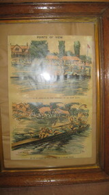 City of Warrnambool Rowing Club
Picture (copy), "Points of View"
Half page illustration from Punch p. 37. Two panel illustration by G.D. Armour titled 'Points of View' and subtitled 'The River as it Appears to the Winners of an Easy Race' showing starboard view of a straight four rowing erect and without obvious distress. Below 'As it Appears to the Losers of a Hard Race' showing closeup starboard stern quarter view of a straight four collapsed over their oars, with the surrounding scenery drawn in a wavy haze. Part of the Tom Weil Collection. Thomas E Weil is a very knowledgeable and respected collector of rowing memorabilia from all over the world. His extensive collection includes material from many years of the Oxford and Cambridge University Boat Race, and Henley Royal Regatta. He also lectures and writes on rowing history and is a Trustee of the River and Rowing Museum. River & Rowing Museum, Mill Meadows, Henley on Thames, Oxfordshire, RG9 1BF Telephone: 01491 415600 General enquiries: [email protected] of an Ink and watercolor painting of two rowing crews. Two panel copy of an illustration by G.D. Armour titled 'Points of View' and subtitled 'The River as it Appears to the Winners of an Easy Race' showing starboard view of a straight four rowing erect and without obvious distress. Below 'As it Appears to the Losers of a Hard Race' showing closeup starboard stern quarter view of a straight four collapsed over their oars, with the surrounding scenery drawn in a wavy haze.Points of view G.D. Armourcity of warrnambool rowing club, warrnambool rowing club, hopkins river warrnambool, hopkins river warrnambool, g.d. armou, 'points of view' -
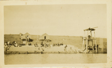 Kew Historical Society Inc
Photograph - Deep Rock Swimming Pool and Clubrooms on the Yarra, c.1925
The former Deep Rock Swimming Pool was about 500 yards [457 metres] above Dight’s Falls. It was there that the Deep Rock Swimming Club was established in 1906. This initial club was expanded in 1916 to incorporate a life-saving club. In 1918, John Wren, the president of the club offered the club £1000, and undertook to sponsor a patriotic carnival in March 1918, at which swimming champions would take part. The ‘pool’ was to achieve fame as the venue for a world record-breaking ‘swallow dive’ of 205 feet 9 inches [63 metres] by ‘Prince Wickyama’, [aka Alec Wickham], a Solomon Islander. The dive from a special platform on the west side of the Yarra was reputedly viewed by between 50,000-100,000 spectators, with funds going to the State War Council. The Herald, 25 March 1918, claimed that the wide area occupied by spectators made more precise estimates impossible. In the 1980s, the construction of the Eastern Freeway, and the consequent re-routing of the Yarra River led to the site of the Deep Rock Pool being obliterated. A small cairn and plaque on the Fairfield side of the river now marks its former site.Very rare early photograph off the Deep Rock swimming pool. The pool and its built structures are historically and socially important to the people of Collingwood, Fairfield and Kew. Small, faded, Gelatin Silver print positive photograph of the Deep Rock Swimming Pool situated on the Yarra at Collingwood and Fairfield. The famous diving tower is at the right of the photo. The built structures were constructed for the Deep Rock Swimming and Life Saving Club. People are sitting on the terraces above the river. "Bathing Club. Deep Rock on the Yarra. Studley Park Melbourne. Please credit E.J. Thomasson Collection"deep rock swimming pool, deep rock swimming club, deep rock lifesaving club, swimming -- river yarra, river yarra