Showing 3069 items matching "scales"
-
 Glenelg Shire Council Cultural Collection
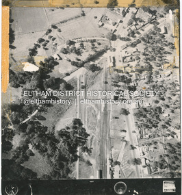
Photograph - Photograph - aerial view of Portland, c. 1954
Black and white aerial photograph of coastline around Portland. Black border, scale all sides, 5 rows of 3 't' at regular intervals. Small area of ocean, rest land with lakes.Front: '820 -9' - handwritten, white, border 'RUN 5' 'PORTLAND', printed, white, lower borderaerial photography, central portland, portland harbour, coastline -
Glenelg Shire Council Cultural Collection
Photograph - Photograph - aerial view of Portland, c. 1954
Black and white aerial photograph of coastline around Portland. Black border, scale all sides, 5 rows of 3 't' at regular intervals. Very small section of ocean, bottom left.Front: '607 -86 ' - handwritten, white, border 'RUN 6- PORTLAND', printed, white, borderaerial photography, central portland, portland harbour, south west coastline -
Glenelg Shire Council Cultural Collection
Photograph - Photograph - aerial view of Portland, c. 1954
Black and white aerial photograph of coastline around Portland. Black border, scale all sides, 5 rows of 3 't' at regular intervals. Start of headland, 80/20 ocean to landFront: '784 - 149' - handwritten, white, border 'RUN 7 A PORTLAND', printed, white, borderaerial photography, central portland, portland harbour, south west coastline -
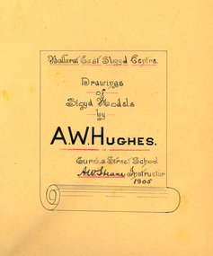 Federation University Historical Collection
Book, A.W. Hughes, Drawings of Sloyd Models, 1905, 1905
A.W. Hughes was a student of the Ballarat east Sloyd Centre, Eureka State School, in 1905. His instructor was Albert W. Steane. Albert Steane was one of the first trained sloyd teachers in Victoria.Black hard covered drawing book with drawings,done my hand, of sloyd models by A.W. Hughes.The work is drawn in black and red ink, each model is numbered and named, and the scale is given. ballarat junior technical school, steane, albert steane, a.w. steane, hughes, a.w. hughes, sloyd, ballarat east sloyd centre, eureka street school. drawing -
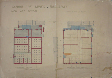 Federation University Historical Collection
Plan, Plan for the Ballarat Technical Art School, c1914, 05/04/1913
The Ballarat Technical Art School building opened in 1915. It was a division of the Ballarat School of MinesPlanes for the Ballarat Technical Art School basement and ground floor, featuring hand coloured sections. Wood Carving and Metal Working were located in the basement. Scale is 8 feet to 1 inch School of Mines Ballarat New Art School C.B.G.5.4.13ballarat school of mines, ballarat technical art school, plan, buildings, metalwork, wood carving, freehand and plant drawing, model and cast drawing, lecture room, modelling room, light and shade, architectural drawing -
Bendigo Historical Society Inc.
Map - CAMPBELL COLLECTION: BENDIGO AND DISTRICT MAPS, 15-2-29
Map. Nerring, Parish of Nerring, scale 20 chains to 1 inch. Prepared in W.P.B. from A. and P. Plans by W.J. Galbraith. 15-2-29. (number 379 in map cupboard 1)W.J.Galbraithmap, bendigo, agricultural lands -
Bendigo Historical Society Inc.
Map - CAMPBELL COLLECTION: BENDIGO AND DISTRICT MAPS, 15-2-29
Map. Nerring, Parish of Nerring, scale 20 chains to 1 inch. Prepared in W.J.B. from A and B plans by W.J. Galbraith 15-2-29. (number 356 in map cupboard 1)W.J.Galbraithmap, bendigo, parish plan -
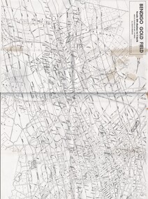 Bendigo Historical Society Inc.
Map - MAP OF BENDIGO GOLDFIELDS
Map. Copy of a map of the Bendigo Goldfields issued by the Dept. of Mines showing lines of reef, mines and streets. Scale 20 chains to 1 inch. Printed by Cambridge Press, Bendigo. Date unknownmap, bendigo, goldfields, map, goldfields, department of mines -
 Bendigo Historical Society Inc.
Negative - BILL ASHMAN COLLECTION: VARIOUS NEGATIVES
7 black and white negatives and 1 larger one. Contained in a beige envelope. Br 1235 3/- written on the envelope. One negative is a Scalebuoy, 1 is the interior of a room and the rest are photos of scales?sciences, instruments - general, scalebuoy, bill ashman collection - correspondence, negatives, envelope -
Port Melbourne Historical & Preservation Society
Map - MMBW, Oct 1894
Melbourne and Metropolitan Board of Works 1894 Plan No. 10 Segements shown: 363, 367 and 368 Large scale (40'=1") Swallow Street to Railway Place, Railway pier to mid railyards"Copywrited 14.1.95" written in red ink "311/H"engineering - board of works, business and traders - hotels, transport - railways, transport - tramways -
Whitehorse Historical Society Inc.
Map, Dandenong Ranges Area, 1956
Sheet 1. Parts of Parishes: Nunawading, Warrandyte and Ringwood. Scale: 10 chains : 1 inch. Contour intervals marked and locations of buildings.Sheet 1. Parts of Parishes: Nunawading, Warrandyte and Ringwood. Scale: 10 chains : 1 inch. Contour intervals marked and locations of buildings. Compiled from aerial photographs and cadastral survey information.Sheet 1. Parts of Parishes: Nunawading, Warrandyte and Ringwood. Scale: 10 chains : 1 inch. Contour intervals marked and locations of buildings. maps, ringwood, mitcham, warrandyte -
Whitehorse Historical Society Inc.
Map, Melbourne and suburbs, 1923
Section of map 'Melbourne and Suburbs' compiled at the Department of Lands and Survey, Melbourne by E. S. Hilcke, March 1923, reprinted 1940.Section of map 'Melbourne and Suburbs' compiled at the Department of Lands and Survey, Melbourne by E. S. Hilcke, March 1923, reprinted 1940. Scale 40 chains: 1 inch. - Shire of Blackburn and MitchamSection of map 'Melbourne and Suburbs' compiled at the Department of Lands and Survey, Melbourne by E. S. Hilcke, March 1923, reprinted 1940.department of lands and surve, melbourne and suburbs -
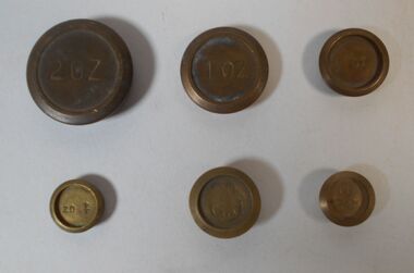 Bendigo Historical Society Inc.
Functional object - Set of weights
BHS CollectionA set of six weights for balance scales, possibly for weighing gold. We have a 2, 1, 1/2 and 1/4 ounces and a 20 and 10 GM. Aileen and John Ellison Collection.weights, balance -
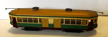 Ballarat Tramway Museum
Model - Model Sydney R class tram
Model of a Sydney R class tram - operable - painted in Sydney Tramway colours. The Sydney Tramway Museum has a number of them in their fleet though most are stored.Demonstrates an model that represented the later type of a drop-centre saloon car type trams operated on the Sydney tram network until closure in 1961.Model of Sydney Tramways R class tram, plastic with operable trolley poles. HO Scale. Has been fitted with two different motors with "01217" marked on the smaller motor. No information as to the manufacturer.models, tramcars, sydney, r class -
Beechworth Honey Archive
Map- Chiltern/Barnawartha
(4x) Map centred on Chiltern and Barnawartha. Shows Murray River, Hume Highway, Chiltern- Barnawartha Rd and Chiltern- Rutherglen Rd. Scale 1:50,000. Paper is white on back, yellow on front.Map labelled 'Albury series R652' Some markings in red and blue on some maps- blue writes '74-75'map, chiltern, barnawartha, paper, beechworth honey -
University of Melbourne, Burnley Campus Archives
Map, Melbourne and Metropolitan Board of Works Plan No. 42 Richmond, c.1884-1891
Photocopy of Melbourne and Metropolitan Board of Works Plan No 42 M 387 ₍₄₂₎ of Richmond from plans dated c1884-1891. Shows A. Lynch's Plan of the Gardens. Scale 160 ft. to 1 inchOriginal stamped "Original Plan Room"melbourne and metropolitan board of works, richmond, burnley gardens, richmond park -
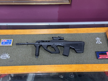 The 5th/6th Battalion Royal Victoria Regiment Historical Collection
Decorative object - 5/6 RVR miniature rifle and badges, 5/6 RVR miniature rifle and patch and badges
1/4 scale EF-88 rifle in plastic materials, with a rising hat badge, 5/6 RVR hat badge, AUS flag colour patch and 5/6 unit patchall the items are fixed onto the board -
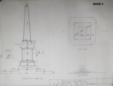 Bendigo Military Museum
Plan - MONUMENT PLANS, C.1992
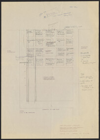
These plans were for a proposed Memorial to Ex Servicemen and Women to be erected in front of the Soldiers Memorial Institute in Pall Mall Bendigo. This building is now known as "The Bendigo Military Museum".1) .2) Two Cronaflex .004 thick black ink plans , scale 1 - 100showing front elevation and plan of a proposed Monument. Both plans are slightly different showing plan sections."Proposed Monument to Ex Servicemen and Women to be erected in Pall Mall Bendigo"brsl, smirsl, monument, plan, -
 University of Melbourne, Burnley Campus Archives
Plan, Proposed Layout Groundcover Evaluation/Demonstration Plots Burnley College, 1996
(1) Tracing paper and 2 paper copies, one with plant names added, `drawn by JK 27.6.96, plans of site. Scale 1:10 (2) List of Materials and Plants, with handwritten alterations.burnley college, ground cover, garden supplies, demonstration plots, jill kellow, trees, plant nurseries -
 Bendigo Historical Society Inc.
Map - CAMPBELL COLLECTION: BENDIGO AND DISTRICT MAPS
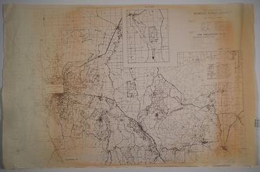
Map. Forest Commission Victoria, Bendigo Forest District, Basic information prepared 1982, scale 1:100,000. Fire Prevention Strategy Plan. Mitiamo, Greater Bendigo Area, Castlemaine F.D.map, bendigo, forest district -
 Bendigo Historical Society Inc.
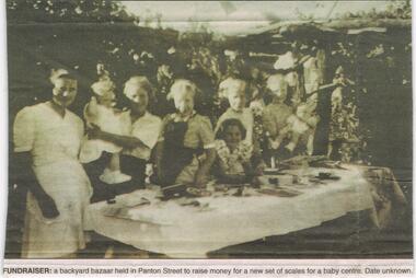
Newspaper - JENNY FOLEY COLLECTION: FUNDRAISER
BHS CollectionBendigo Advertiser '' The way we were'' from 2002. Fundraiser: a backyard bazaar held in Panton Street to raise money for a new set of scales for a baby centre. Date unknown. The clip is in a folder.newspaper, bendigo advertiser, the way we were -
Clunes Museum
Map, 1890
Features location of Club Hotel, Union Bank, Engine rooms, Port Phillip Hotel, Pyrites furnace, Battery, Office, Smith Shop,Surface Tramway to BatteryPhotocopy of map/plan of Dixon's New North Clunes, Central Clunes Co. and South Clunes utd showing various shafts and pre-emptive rights. Scale 1 inch = 100 feetOn front in red ink; "drawn in 1890"mine shafts, hotels, plans -
 Federation University Historical Collection
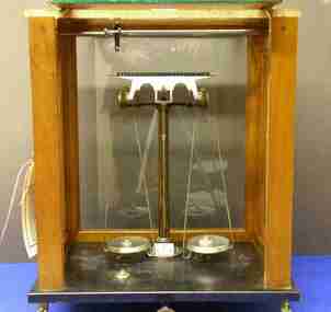
Instrument - Scientific Instument, Beam Balance
... scales ...This beam balance was used at the Ballarat School of Mines Beam balance housed in a glass-sided wooden cabinet. Completer, but without balance masses.scientific instrument, balance, scales, physics laboratory, chemistry laboratory, beam balance -
 Victorian Interpretive Projects Inc.
Photograph - Colour, Clare Gervasoni, Ballarat Railway Station Weighbridge, 2011, 27/03/2011
... scales ...The weighbridhe is heritage listed and was believed to have been used to weigh train carriages carrying wheat.Colour photographs of the Ballarat Railway Station weighbridge and associated building. The building was destroyed by fire in November 2014.ballarat railway station, weighbridge, scales, tracks, railway, wheat -
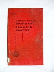 Bay Steamers Maritime Museum
Book, The Institute of Engineers, Australia, Australian Standard Engineering Drawing Practice, 1951
... scales ...Red hard cover book of 191 pagesFront page handwritten in pencil "J.T. Young / I.C.I Osborne / Fuel Economy / C.E.D" non-fiction, drawing, engineering, graphs, scales, projectioning -
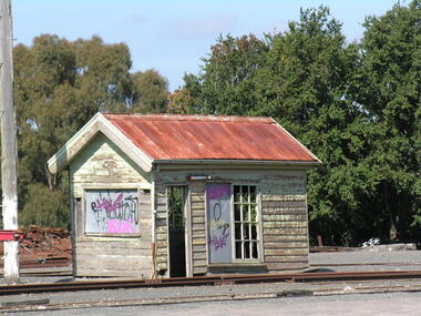
 Eltham District Historical Society Inc
Photograph - Aerial Photograph, Main Road and Anzac Ave intersection, Hurstbridge, 12 Apr. 1954
Victorian Railways Aerial SurveyStamped VR Aerial Survey This print is not rectified Scale Approx 160' to 1 inch Date Photographed 12.4.54 Written Series 33, Item 9shire of eltham archives, aerial photo, main road, anzac avenue, hursbridge, parker road, hurstbridge railway station, rose road -
 Flagstaff Hill Maritime Museum and Village
Plan - Lines Plan, S.S. Rowitta, ca 1909
The lines plan was drawn for the building of the steamship S.S. Rowitta, a passenger steam ferry built in Hobart for use in Tasmania's rivers, the Derwent and the Tamar. It is a copy of the original lines plan. The S.S. Rowitta was built by Purdon & Featherstone, at Battery Point, Hobart (Tasmania) in 1909 from Huon Pine and Kauri planking. Her final configuration included three masts and a ship rig. S.S. Rowitta took its first voyage from Hobart to Launceston in 1909 and operated for 30 years as a passenger ferry on the Tamar and Derwent Rivers. She also served as a freighter, an army supply ship, a luxury charter ferry and a floating restaurant as well as a prawn boat at Lakes Entrance. (She has also been named “Sorrento” and “Tarkarri”.). In the very early days of Flagstaff Hill ‘Rowitta’ was purchased from Lakes Entrance by Warrnambool City Council and the Victorian State Government for $20,000. The Rowitta had a hull configuration very similar to a local boat named the SPECULANT, which played a key role in the Port of Warrnambool in the early 1900s. The Speculant was the largest ship ever registered with Warrnambool as her home port. Local owner and trader P J McGennan & Co, (Peter McGennan) used her as a freight carrier to Melbourne and timber trader between New Zealand and Victoria. She sunk at Cape Otway in 1911 on a voyage to Melbourne. In 1974 Rowitta was delivered to Port Fairy and then later sailed to Warrnambool’s Breakwater where she was lifted out of Lady Bay and loaded onto the back of a long transport truck and slowly and carefully driven along Pertobe Road, through the Surfside Caravan Park and over the railway line, into Flagstaff Hill’s Maritime Village. Transfer arrangements were coordinated by Jack Morse, of Morse Engineering, a member of the Flagstaff Hill Planning Board, and Ken Goyen, a local crane operator. The ‘Rowitta’ was originally acquired to be rebuilt to match the original SPECULANT. When finances became tight in 1976 a review of all plans ended in the decision to restore the “Rowitta” to her original configuration. She was then restored, renamed the original name of “Rowitta” and installed in the Village’s Harbour Lake to become one of the popular vessels on display for visitors to enjoy. It was the decision of the Advisory Committee to Flagstaff Hill to have Rowitta demolished in April 2015 due to extensive deterioration. Items associated with the Rowitta continue to be held in Flagstaff Hill Maritime Village’s Collection.The lines plan of the passenger ferry S.S. Rowitta.is significant for its association with Tasmanian history from the early to mid-1900s. It is also connected to the history of the Rowitta, which was a large exhibit on display at Flagstaff Hill Maritime Village from the museum’s early beginnings until the vessel’s end of life 40 years later. The Rowitta represents the importance of coastal traders to transport, trade and communication along the coast of Victoria, between states, and in Australia before rail and motor vehicles. The vessel was an example of a ferry built in the early 20th century that served many different roles over its lifetime of over 100 years. Lines Plan, copy, of the steamship S.S. Rowitta. Rectangular drawing paper with copy of the hand drawn lines plan showing several profiles of the vessel. The vessel was built in 1909 by Purdon & Featherstone, Hobart. On the revers is handwritten inscription, and a white label with a handwritten number.Printed on the plan: "S.S. ROWITTA / LINES PLAN / SCALE 1/4" TO 12" " Blue ink writing on the back: "Rowitta" Blue ink on label: "56"flagstaff hill, warrnambool, shipwrecked-coast, flagstaff-hill, flagstaff-hill-maritime-museum, maritime-museum, shipwreck-coast, flagstaff-hill-maritime-village, photograph, s.s. rowitta, charles street wharf,, launceston., purdon & featherstone, rowitta, tarkarri, speculant, purdon & featherstone of hobart, passenger ferry 1909, sorrento, lines drawing, ship's plan, lines plan, line plan, shipbuilding, ferry -
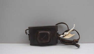 University of Melbourne, Burnley Campus Archives
Functional object - Camera, Ferrania Condor 1 camera in leather case
Ferrania Condor 1 camera in leather case with strap. ferrania condor 1 on metal top. On lens OFFICINE GALILEA ISCUS RAPID with relevant numbers and scales. ferrania stamped on front of leather lens cover.camera, ferrania -
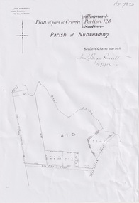 Whitehorse Historical Society Inc.
Plan, Portion 128 Parish of Nunawading, 13/03/1902
A4 Plan of part of Crown Portion 128 Parish of Nunawading dated 13/03/1902Photocopynon-fictionA4 Plan of part of Crown Portion 128 Parish of Nunawading dated 13/03/1902schwerkolt august, plans, parish of nunawading -
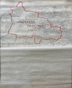 Federation University Historical Collection
Map, Ballarat Municipalities and City Boundary
Piece of linen attached at top and bottom with wooden rails. Top half of linen has a paper map of Ballaarat Province and Surrounding Municipalities directly attached to it and reads 'Ballaarat Province' in red ink which outlines the greater Ballarat area with surrounding municipalities shown in blue. Scale is '8 miles to 1 inch'. Bottom half is drawn directly onto linen and depicts Ballaarat City Boundary including street names. 'Scale about 20 chains to 1 inch'.ballarat electorate, map, ballaarat province, ballarat to buninyong railway