Showing 10799 items
matching sites
-
 Lakes Entrance Historical Society
Photograph, Lakes Post Newspaper, 1990
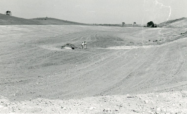
Black and white photograph of works at Tambo Water Board ,site Lagoon no. 1 Metung Metung Victoriasewerage -
 Williamstown Historical Society Inc
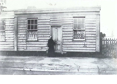
Photograph - Ferguson St, Williamstown
Mrs Burge in front of her house, Ferguson St, Williamstown. House demolished for Town Hall site mrs burge, ferguson st, williamstown, house, town hall -
 Bendigo Historical Society Inc.
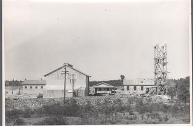
Photograph - Carshalton Headframe, 1935
Significant to mining history of Bendigo.Black and white photograph : image shows metal headframe at Carshalton mine site. Mine sheds in background. Written in pencil on back of photograph in pencil: 'Carshalton headframe 14.6.35'carshalton gold mine, diesel compressor, winder -
 Bendigo Historical Society Inc.
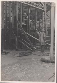
Photograph - Carshalton Gold Mine, 1935
Significant to mining history of Bendigo.Black and white photograph : image shows Carshalton gold mine site; mine sheds under construction. Written in pencil on back of photograph in pencil: 'Carshalton 11.12.34'carshalton gold mine -
 Falls Creek Historical Society
Document - Voters' Roll For Commercial Licensees' Representative
Bob (Herman) Hymans (a former member of the Royal Netherlands Navy) was born in Bloemendaal, Holland on 30th September 1922. During World War II he fought against the Japanese in the Dutch East Indies (now Indonesia) and was imprisoned in Changi and on the Burma Railway. After gaining qualifications as a Ski Instructor, Bob arrived in Falls Creek in July 1950. Working as an Instructor and Supervisor at Bogong Lodge, Bob decided his future was in accommodation. He was successful in negotiating an indenture for land from the State Electricity Commission (SEC). It took Bob two years to build his Grand Coeur Chalet but, tragically, it was burned down in August 1961. Bob also built the first Chairlift in Australia. This was a single chairlift and the structure was built from wooden electricity poles. He was constantly full of new ideas and proposals for the village. Bob Hymans died on 7th July 2007. This Collection of documents and letters tells the story of Bob's endeavours to develop Falls Creek into the ski village it is today.This item is significant because it documents actions taken by the Falls Creek Tourist Area Management Committee in their role overseeing the Tourist Area.A voters' roll listing all those eligible to vote for the Commercial Licensees Representative to the Falls Creek Area Management Committee. 35 Voters are listed on the roll. The information includes the Site number occupied, names and contact details, and in some cases the name of the person to cast the vote if there was more than one holder of the lease or licence. Bob Hymans is listed as the licensee for SIte 4 - Four Seasons Lodge and Site 4A - Southern Cross Flats. falls creek tourist area management committee, falls creek administration, bob hymans -
 Surrey Hills Historical Society Collection
Photograph, Holy Trinity Church of England, Surrey Hills during construction, 1922, 1922
St George's Church of England, Mont Albert was built in 1886 and from 1904 until 1907 was known as Holy Trinity, Surrey Hills. As the population increased there was a need for a church in Surrey Hills. This brick church was consecrated in 1922 and replaced the earlier one built in 1907 on the adjacent site in Union Road. The house behind the church at 1 Montrose Street belonged to Mr W B Vine. There are 2 copies: the original donated print and an enlargement. The original is mounted on card with photo mounts along with 884, 885, 886 and 512. It measures 13 cm x 9 cm. Norman Carter took many photos of Surrey Hills and Mont Albert in the 1920s; many were associated with events and activities of the Church of England.Black and white photo of 3 men inspecting the construction site of the Holy Trinity Church of England in Union Road, Surrey Hills. The foundations are surrounded by piles of bricks. In the background is a small timber shed and beyond that a timber Edwardian home partly hidden by foliage.churches, holy trinity church, anglican church, building construction, montrose street, w b vine -
 Orbost & District Historical Society
black and white photographs, 1974 - 1976
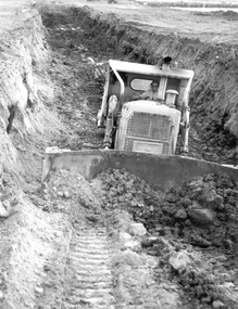
Construction of the roadway embankment between the bridges across the Snowy River flood plains at Orbost commenced in January 1974 and was completed in November 1976. Pearsons were the bridge contractors for the construction of the Princes Freeway and bridges across the river flood plains at Orbost. Heavy rains and floods held up progress.These photographs are of the construction of a major structure in Orbost. The opening of this Snowy River Bridge was an important development in the accessibility to the township of Orbost.Four black / white photographs of construction sites. 3241.1 is of three cranes and other machinery with six persons. 3241.2 is of workmen working on flooded site. 3241.3 is a photograph of the early stages of construction of a bridge looking towards the township. 3241.4 shows the construction of a roadway between the bridges.construction-snowy-river-bridge bridge-orbost -
 University of Melbourne, Burnley Campus Archives
Administrative record - Garden Management and Maintenance, Victorian College of Agriculture and Horticulture, Miscellaneous Planning Documents, C.1997
master plan, burnley gardens, garden maintenance, garden management, vcah, herb garden -
 Ringwood and District Historical Society
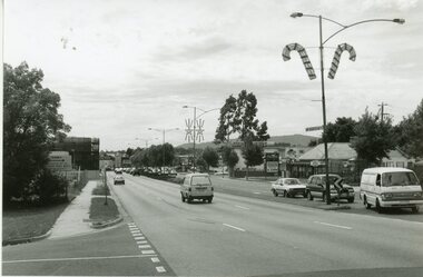
Photograph, Maroondah Highway East, Ringwood- 1969. Looking west towards Ringwood from Everard Road
Black and white photographWritten on back of photograph: "Site of Cass's school, 1874. (1 acre left out of 5 acres). -
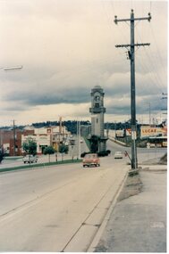 Ringwood and District Historical Society
Photograph, Ringwood Clocktower - circa 1960's
Postcard size colour photograph'Written on back of photograph" Clock Tower - original site, middle of Maroondah Highway and Warrandyte Road intersection. -
Glenelg Shire Council Cultural Collection
Photograph - Photograph - Henderson & Cross Wheelwrights, Portland, n.d
Black and white photo attached to beige cardboard mount. Workshop of Henderson & Cross, Wheelwrights and Horseshoers, in Percy St. Portland. Corrugated iron building large open wooden doors, several men standing outside, numerous spoked wheels, 3 horses on right.Back: 'VIVIAN' 'Portland On site of Mrs. A. Naismiths' home Percy St.' - hand printed in blue birotrade, industry, travel, wheelwright, horseshoer, portland, percy street -
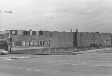
 Ringwood and District Historical Society
Photograph, Maroondah Highway Central, Ringwood. Site of old Town Hall, cnr. Maroondah Highway and Melbourne St, Ringwood - 1971
Black and white photograph (2 copies- 1 large, 1 small)Written on rear backing sheet: "Site of old town hall. Cnr. Maroondah Highway and Melbourne St." -
 Ringwood and District Historical Society
Photograph, Maroondah Highway Central, Ringwood. Site of old Town Hall cnr. Maroondah Hwy and Melbourne St., Ringwood - 1971
Black and white photograph (2 copies- 1 large, 1 small)Written on rear of backing sheet: "Site of old Town Hall cnr. Maroondah Hwy and Melbourne St." -
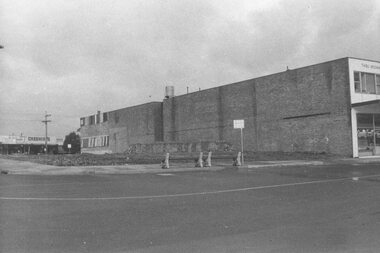
 Ringwood and District Historical Society
Photograph, Maroondah Highway Central, Ringwood. Shops on site of old Town Hall, corner of Melbourne Street, 1972
Black and white photograph (2 copies) Written on rear of backing sheet: "Shops on site of old Town Hall. Cnr. Melbourne St. 1972" -
 Glenelg Shire Council Cultural Collection
Photograph - Photograph - wheat storage construction, Portland, c. 1970
Port of Portland Authority archivesFront: (no inscriptions) Back: Northern Trench, Wheat Storage Site, June 11th (pencil, upper left)port of portland archives, wheat storage, construction -
Glenelg Shire Council Cultural Collection
Photograph - Photograph - wheat storage construction, Portland, c. 1970
Port of Portland Authority archivesFront: (no inscriptions) Back: Southern Trench, wheat storage site, June 11th (pencil, upper left)port of portland archives -
 Kew Historical Society Inc
Photograph - Burgess House, Victoria Street (Abbotsford), 1880-1900
Major floods recurred of the Yarra River on a regular basis. A flood in 1901 destroyed this house in Victoria Street, Abbotsford. Later print copy of an original photograph. Home of C/N Burgess on the south side of Yarra River. The buildings were washed away in a flood in 1901 The house was in the same location as that on which Handley & Tilly was later built. This would locate it on the north side of Victoria Street, Abbotsford between Burnley Street and the Victoria Street Bridge. Photo shows three men and one woman working in an established garden in front of a weatherboard cottage."Home of C/N Burgess on south side of river; washed away in 1901; Handley & Tilly on site"yarra river -- floods, yarra river flood -- 1901, burgess family -- victoria street -- abbotsford (vic.) -
 Ringwood and District Historical Society
Photograph, Maroondah Highway Central, Ringwood. Bus terminus at Railway Station, 1969
Black and white photographWrittren on back of photograph: "May 1969, bus terminus at Railway Station. Site of Station Masters house. -
 Ringwood and District Historical Society
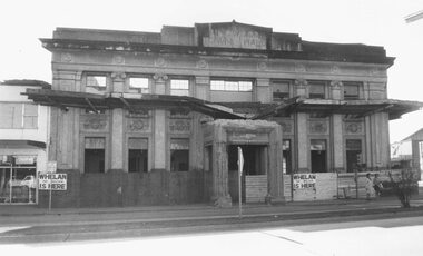
Photograph, Maroondah Highway Central, Ringwood. Demolition of Ringwood Town Hall - 1971
Black and white photograph (2 copies- 1 large, 1 small)Whelan the Wrecker is here, midway Alexander Clothing to leftWritten on backing sheet, "Town Hall demolition". Sign at front of site reads- 'Whelan the wrecker is here'. -
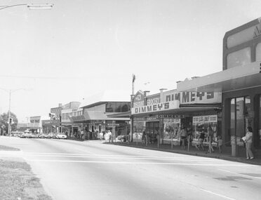
 Ringwood and District Historical Society
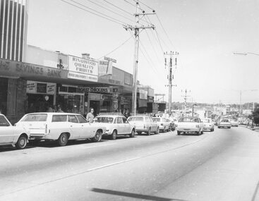
Photograph, Maroondah Highway Central, Ringwood. Main St. shops opp. old Ringwood Town Hall site, 1974
Black and white photograph.Written on rear of backing sheet: "Main St. shops opp. old Town Hall site, 1974". -
 Ringwood and District Historical Society
Photograph, Ringwood black and white photographs
Black and white photographMaroondah Hwy. view East from bonview Ave near proposed site of Eastern Ring Road -
 Bendigo Military Museum
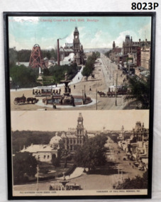
Photograph - CHARING CROSS, PALLMALL SMI, MOUNTED, C.2000
The mine was the “Hustlers Royal Reserve Mine No 2” and was closed in 1912. The Soldiers Memorial Institute was erected on the mine site and opened on 15.11.1921 and occupied by the Bendigo RSL Sub Branch/Bendigo District RSL Sub Branch Inc since then. The mine shaft capped sits about centre of the building.Two gloss coloured prints on fibre board backing. Top photo tinted of Alexander Fountain, Charing Cross and Pall Mall Bendigo. Gold mine poppet head and buildings on left hand side. 53464 VJ printed on R.H.S. bottom. Bottom photo black and white of Panorama of Pall Mall., Bendigo, Vic. Soldiers Memorial on left hand side occupying old gold mine site.“The Southern Cross Series 10399. Copyright on bottom L.H.S. Panorama of Pall Mall, Bendigo on R.H.S. bottom”brsl, smirsl, hustlers -
 Bendigo Historical Society Inc.
Document - Phillip's Water Wheel, Diamond Hill, Bendigo, 1876
'Messrs. George Phillips and Richard Williams erected a water wheel crushing machine near the site of the Old Albert shaft at Diamond Hill'. ( Bendigo Advertiser 4th June, 1890). The lack of water available for the venture from the water race caused much controversy in the following years. There was only enough water available in July 1890, to allow the company to operate three head of a ten head stamper. The site of the water wheel is still visible on the side of the water race at Diamond Hill. Mr. Geo Phillips held 1000 shares in the float of the Kangaroo Hydraulic Crushing & Gold Mining Company. He was one of the largest shareholders. (Victorian Government Gazette 72 Page 2260, 1893) Black and white photocopy. Image shows the Phillip's Water Wheel on Diamond Hill, Bendigo, date unknown but must be in 1890's. Three men and a dog standing in front of a weatherboard shed, brick chimney on side. Large water wheel on left hand side of image. Three images, 2008, showing former site of water wheel on channel, after heavy rain in district caused dry channel to run. mining, sandhurst, phillip's hydraulic waterwheel, stafford gold mine, diamond hill, george phillips, richard williams -
 Tarnagulla History Archive
Photograph of stables behind bank building, Tarnagulla, Stables behind bank building, Tarnagulla, circa 1970s
Murray Comrie Collection. This image depicts the stables at rear of a two-storey bank building in Tarnagulla. The bank building was used first by the Colonial Bank of Australasia (from 1866 to 1888) and then by the Union Bank (from 1888 to 1942). The two-storey bank building was built in 1866 by the Colonial Bank of Australasia. Before this, the site had been occupied by Foo's shop. Whilst it was being built, the Colonial Bank operated from Company's Hotel (later known as Burstall Hall and the Council Chambers). The new double-storey building was used by the Colonial Bank from 1866 until 21st February, 1888. The premises were sold to the Union Bank for £2500. The Union Bank moved in and commenced operations on 6th June 1888, continuing until 1942. The building was later used as a general store until the 1990s. It is now a private residence. This is a reasonable copy of an older original. Copy probably made by Murray Comrie in the 1970s. Monochrome photograph depicting stables at rear of the double-storey bank building in Tarnagulla. Image depicts a brick building with white timber doors and corrugated metal roof. The site was originally built by and for the Colonial Bank and later used by the Union Bank. tarnagulla, banks, banking, commerce, buildings, commercial road, horses, stables -
 Federation University Historical Collection
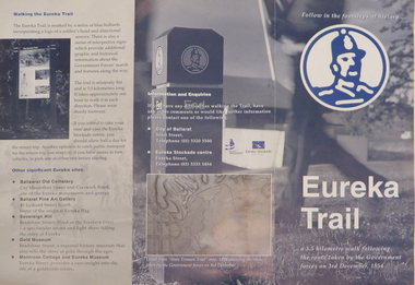
Brochure, Eureka Trail, c2000
The brochure gives information on the Eureka Stockade which took place on 03 December 1854. The Eureka trail aimed at enhancing the Eureka experience and was developed in 1996. It was managed by the City of Ballarat with funding assistance form the State and Federal governments. Much of the work was undertaken under the New Work Opportunity Programme.Blue and white brochure highlighting relevant Eureka Stockade site. The brochure includes a map showing the route the Government forces took on their way to the Eureka Stockade as well as sites of interest to Eureka which are marked by blue bollards. The brochure was presented by the City of Ballarat and the Eureka Stockade centre.eureka, eureka stockade, diggers' trail, trooper's trail, eureka stockade centre, city of ballarat -
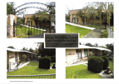 Eltham District Historical Society Inc
Document - Folder, Eltham War Memorial Complex, 1961
Background context for the establishment of the Eltham War Memorial as a living memorial, championed by the women of the community with the establishment of the Eltham War Memorial Trust and how the memorial was funded by public donations and eventually handed over to Council. The essay came about in 2018 following community protest at Council's plans to sell the land. Following abandonment of the sale process and putting development on hold, community groups pulled together to apply for heritage protection of the site with Heritage Victoria. This was formally rejected in May 2020.Contents: An essay addressed to the Councillors of Nillumbik Shire, October 2018: About the Eltham War Memorial and the adjacent community-owned sites in Eltham that the Council threatens to sell, Andrew Lemon Nov. 2018 Public Notice: Heritage Act 2017, Recommendations to the Heritage Council, Heritage Council Victoria, The Age, May 22, 2020, p34eltham war memorial, eltham war memorial trust, mrs. ada lyon, mrs. cairns officer, mrs. j.j. morrison, andrew lemon, children's library, eltham war memorial garden, eltham war memorial gate, eltham war memorial hall, garden of remembrance, heritage council victoria, nillumbik shire council, theodore feldbauer, violet feldbauer (nee teagle) -
 Williamstown High School
Old Naval Drill Hall
Copy of black and white photograph mounted on board. Accompanied by a captionCaption reads: The Old Naval Drill Hall Assemblies, physical education, social occasions and fund-raising activities happened in this old hall. Some other buildings on the site were used for classrooms and examination areas when there was no space left on the school site.drill hall, williamstown high school, 1960s -
 Glen Eira Historical Society
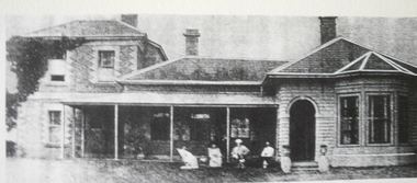
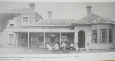
Caulfield Properties
Photograph of Glen Huntly built by Thomas Watts, date unknown, on site of where Holy Cross church now isglen huntly, glen huntly road, houses, watts, thomas, holy cross church, churches -
 Glen Eira Historical Society
Caulfield Properties
Photograph of Glen Huntly built by Thomas Watts, date unknown, on site of where Holy Cross church now isglen huntly, glen huntly road, houses, watts, thomas, holy cross church, churches -
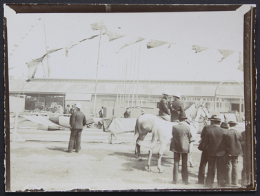 Mission to Seafarers Victoria
Photograph, Mr and Mrs Gurney Goldsmith, Laying the Foundation Stone at the Central institute, Australian Wharf, 5 February 1907, 5 February 1907
Laying the Foundation Stone for the Central institute, Australian Wharf, 5 February 1907. This photo appears to depict the beginning of the event, before diginitaries have arrived, as there are not many spectators.A snapshot of the moment of inception of the Central Institute by the Yarra River. Small monochrome outdoor photograph, depicting the start of a gathering crowd, and some mounted police, at the site of the future MTSVcentral institute, foundation stone, 1907, siddeley street, australian wharf, police, horses