Showing 21486 items
matching the local
-
 Ringwood and District Historical Society
Newspaper - Clipping, Norwood High School, Ringwood, Victoria
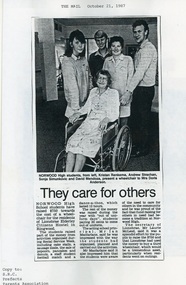
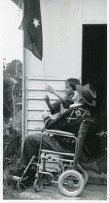
October 1987 local newspaper report on students' Social Service Week fundraising of $750 towards the cost of a wheelchair for Lionsbrae Elderly Citizens Hostel in Ringwood.Photo caption: Norwood High students Kristan Renkema, Andrew Strachan, Sonja Simunkovic and David Mendoza present a wheelchair to Mrs Doris Anderson. -
 Port Melbourne Historical & Preservation Society
Flyer - Port Melbourne Neighbourhood Centre - Term 1 2019, 2018 - 2019
These items were collected by a PMHPS member during 2018-19 and they have been retained as a group of ephemeraVarious ephemera of local interest showing changes in community. Flyer - Port Melbourne Neighbourhood Centre advertising classes to be conducted during January to April 2019documents - flyers, port melbourne neighbourhood centre, social activities, education -
 Bendigo Historical Society Inc.
Newspaper - JENNY FOLEY COLLECTION: SHOPPING TIME
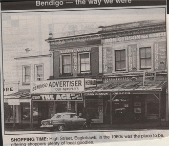
Bendigo Advertiser ''The way we were'' from 1999. Shopping time: High Street, Eaglehawk, in the 1960s was the place to be, offering shoppers plenty of local goodies.newspaper, bendigo advertiser, the way we were -
 Bendigo Historical Society Inc.
Document - NATIONAL TRUST COLLECTION: NEWSLETTER 'LOCAL FOCUS', 1991
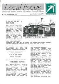
National Trust Central Victorian Branch"Local Focus" Issue 1 July 1991. Includes story about saving "37 Wills Street Bendigonational trust, properties, osmaston 37 wills street, national trust central victorian branch -
 Victorian Interpretive Projects Inc.
Photograph - digital, Proclamation at Jerusalem during World War One, 1918, 1918
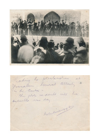
Black and white photograph showing a number of men in army uniform standing on a raised platform/ Locals wearing hats in the foreground The man in the centre is General Allenby. Verso: Reading the proclamation at Jerusalem. General Allenby in the centre. This photo mp doubt will be valuable some day. Palestine 1918.world war, world war one, allenby, general allenby, proclamaton, palestine, jerusalem, mmm -
Clunes Museum
Poster - CALENDAR 1953
ADVERTISING CALENDAR FOR ALEX N MACRAE, LOCAL MERCHANT. WHITE BACKGROUND, PRINTED WITH RED AND BLUE INK, SIX IMAGES OF DOGS PASTED TO THE REVERSE OF THE CALENDARNILalex n macrae, local business, clunes merchant -
 Tatura Irrigation & Wartime Camps Museum
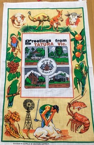
Memorabilia - Tea Towel, Souvenirs Australia, Greetings from Tatura Vic
One of a number of souvenirs available from the Shire of Rodney before it ceased in 1993.Tea towel designed as souvenir of Tatura and Shire of Rodney, local primary industry pictures surround central Shire motif and four pictures of town buildings.Shire of Rodney; Band Rotunda and Gardens: Greetings from Tatura Victoria; Court House; Post Office.souveniers of tatura -
Lakes Entrance Regional Historical Society (operating as Lakes Entrance History Centre & Museum)
Photograph, LE Tidy Town Committee, 1994 c
Also a colour photograph of four people at picnic table adjacent to Northern end of Cunni8nghame Arm Footbridge Lakes Entrance 051`58.1 10 x 15 cmColour photograph showing crowd of people on Cunninghame Arm footbridge at start of the Duck Race a local fundraiser with paddle boats in background Lakes Entrance Victoriawaterfront, gardens -
Lakes Entrance Regional Historical Society (operating as Lakes Entrance History Centre & Museum)
Book, Dunlop E W, The Small Archives Companion
Practical suggestions likely to be of use to those interested in forming and conducting a local Historical Museum, includes ideas on gathering material, displays, conservation, staffing and education.George A Leggheritage, management -
Whitehorse Historical Society Inc.
Article, Or councils to discuss link plans, 1972
Photocopy of an article about Ringwood's agreement to join in a regional conference of councils to discuss the future of local government.Photocopy of an article about Ringwood's agreement to join in a regional conference of councils to discuss the future of local government. Cr Stan Morris was appointed to the agenda committee.Photocopy of an article about Ringwood's agreement to join in a regional conference of councils to discuss the future of local government.city of nunawading, city of ringwood, amalgamations -
Whitehorse Historical Society Inc.
Article, Medal for service, 2003
Article with photograph on Valda Arrowsmith who was awarded a medal of the Order of Australia (OAM) for service to the community of Nunawading and to Local Government in the Australia Day honours for 2003.Article with photograph on Valda Arrowsmith who was awarded a medal of the Order of Australia (OAM) for service to the community of Nunawading and to Local Government in the Australia Day honours for 2003.Article with photograph on Valda Arrowsmith who was awarded a medal of the Order of Australia (OAM) for service to the community of Nunawading and to Local Government in the Australia Day honours for 2003.arrowsmith, valda, awards, australia day -
Whitehorse Historical Society Inc.
Article, Help with history, 1985
The Nunawading Council has received a $16014 grant under the community employment program to employ two people for 26 weeks to index local historical recordsThe Nunawading Council has received a $16014 grant under the community employment program to employ two people for 26 weeks to index local historical records.The Nunawading Council has received a $16014 grant under the community employment program to employ two people for 26 weeks to index local historical recordscity of nunawading, nunawading historical society -
Whitehorse Historical Society Inc.
Article, Business network set up for growth, 1992
A team of Eastern Suburbs businessmen has set up EASTNET for linking resources of local businessesA team of Eastern Suburbs businessmen has set up EASTNET for linking resources of local businesses chaired by Mr David Armitage of Central Spring Works.A team of Eastern Suburbs businessmen has set up EASTNET for linking resources of local businesses eastnet, central spring works, armitage, david -
Whitehorse Historical Society Inc.
Article, Network to help needy
Local families will benefit from the Whitehorse Emergency Relief Network. Thirty-six welfare and community groups will store donations in a central warehouse in Mitcham. With photo.Local families will benefit from the Whitehorse Emergency Relief Network. Thirty-six welfare and community groups will store donations in a central warehouse in Mitcham. With photo.Local families will benefit from the Whitehorse Emergency Relief Network. Thirty-six welfare and community groups will store donations in a central warehouse in Mitcham. With photo.welfare services, fifer, dimity, rooney, keith, whitehorse emergency relief network -
Whitehorse Historical Society Inc.
Article, Women urged to run for Council, 2005
Kaele Way, National President of Australian Local Government Womens' Association and former Whitehorse Councillor, states that more women need to run for Council, with photoKaele Way, National President of Australian Local Government Womens' Association and former Whitehorse Councillor, states that more women need to run for Council, with photoKaele Way, National President of Australian Local Government Womens' Association and former Whitehorse Councillor, states that more women need to run for Council, with photocity of whitehorse, way, kaele, councillors, australian local government womens' association, municipal association of victoria, victorian electoral commission -
 Whitehorse Historical Society Inc.
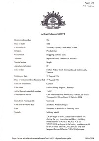
Document, Arthur Haldane Scott, 1914 -1018
WW1 record of Arthur Haldane Scott with reference to 8 sketches of dress adopted in Gallipoli which were reproduced in the ANZAC book. He was a local resident.WW1 record of Arthur Haldane Scott with reference to 8 sketches of dress adopted in Gallipoli which were reproduced in the ANZAC book. He was a local resident.WW1 record of Arthur Haldane Scott with reference to 8 sketches of dress adopted in Gallipoli which were reproduced in the ANZAC book. He was a local resident.scott, arthur haldane, world war 1914 - 1918 *city of whitehorse -
 Lakes Entrance Regional Historical Society (operating as Lakes Entrance History Centre & Museum)
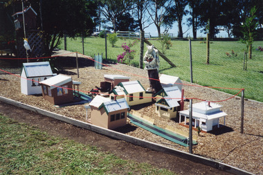
Photograph, 2001
Date made December 2001Colour photograph of the building of a miniature Johnsonville Village, the models are recognisable as local icons, located in the garden of Ian and Lorraine Oatley, Pages Road, Johnsonville Victoriahouses, heritage study -
 Lakes Entrance Regional Historical Society (operating as Lakes Entrance History Centre & Museum)
Photograph, 1992
Appeared in Lakes Post Newspaper 21 October 1992.Black and white photograph of local residents at the ceremony held in the Kalimna West Hall to mark the closure of Kalimna West Primary School. Kalimna West Victoriaschools -
 Lakes Entrance Regional Historical Society (operating as Lakes Entrance History Centre & Museum)
Photograph, 1992
Date made October 1992.Black and white photograph of local residents bringing down flag at Kalimna West School closure, oldest and youngest students in attendance. Kalimna West Victoriaschools -
Lakes Entrance Regional Historical Society (operating as Lakes Entrance History Centre & Museum)
Photograph, 1942
Sepia toned photograph of local soldiers Trevor Lancaster, Fred Henning, Clarie Stevens, Oscar Hammarstrom Front Tom Appleby, Collings at Puckapunyal Victoriareturn soldiers league -
Lakes Entrance Regional Historical Society (operating as Lakes Entrance History Centre & Museum)
Photograph, 1955
Colour photograph of group of nine people outside a temporary hotel built by local sawmillers after the hotel was destroyed by fire in 1954 Nowa Nowa Victoriahotels -
 Lakes Entrance Regional Historical Society (operating as Lakes Entrance History Centre & Museum)
Photograph, Lakes Post Newspaper, 1991
Black and white photograph George Edmond winner 10 km fun run Kinkuna Klassic, to raise funds for local charities. Lakes Entrance Victoriacharities, sports -
 Numurkah & District Historical Society
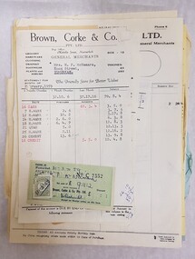
Document - Local business dockets, invoices, reciepts (1950's)
Dockets, invoices, receipts from 1950s local businesses to M.F. McNamara (companies include: Brown & Corke; Bitcons; Heard Bros; Hydes; Picton Hopkins dockets, invoices, receipts, numurkah businesses, 1950's -
 Kew Historical Society Inc
Article, The Kew Floral, Industrial, & Art Society, Kew Floral, Art & Industrial Society, 1897
A newspaper article describing a Kew Floral Industrial & Arts Society event associated with the Congregational Church in Kew. Article describing this 1897 local exhibition of art and industry, opened by the Mayor of Kew, Job Smith, which includes notable attendees and the award winning contestants.kew floral industrial and art society, amy grigg, sunday school competitions - 19th century - kew (vic) -
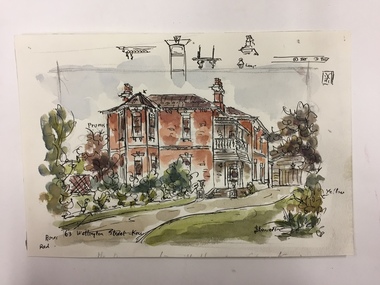 Kew Historical Society Inc
Work on paper, Joy Stewart, 63 Wellington Street, Kew, c. 1978
Sydney Joy (joy) Stewart (1925-2018) was a founding member of the Kew Historical Society, and during the 1970s its secretary. During her residence in Kew, she completed numerous property illustrations on commission. These ranged from preliminary sketches, including architectural details to finished pen & ink and wash illustrations on paper. On moving to Queensland, Joy Stewart donated the remaining property illustrations in her possession to the Kew Historical Society. In 1987-88, she fulfilled a commission by the Society of designs for a series of embroideries completed by residents during the Australian Bicentennial commemorations.Sydney Joy (Joy) Stewart was born in Melbourne 1925. She studied at Swinburne Technical College Art School from 1941-1945, then the National Gallery Art School 1946-1948. Her career included employment positions as a display artist, designer/painter, gallery assistant, and art teacher. Joy relocated to Cairns in 1981. Solo exhibitions in Melbourne and Cairns, including 'Done By Me' at Cairns Regional Gallery in 1999. Group exhibitions at Cairns Regional Gallery, 'The Fish John West Regrets, 1993' and 'Facets of Life' 1994. Joy Stewart died in Cairns in 2018.Watercolour, pen & Ink on paper by the artist and local historian Joy Stewart of a two-storey Victorian-era residence located at 63 Wellington Street, Kew. Inscription: "63 Wellington Street, Kew." Signed lower right: "JStewart".joy stewart, wellington street (kew) -
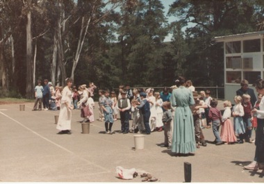 Sunbury Family History and Heritage Society Inc.
Photograph, Bulla Primary School, November 1985
A coloured photograph of the students an teachers from Bulla Primary School assembled in the school yard. Everyone was dressed in colonial costume to celebrate an important local event.bulla primary school, bulla -
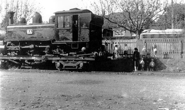 Surrey Hills Historical Society Collection
Photograph, Narrow Gauge Loco 6A on transporter wagon in goods yard at Surrey Hills, 12/05/1950
The engine was being transported because it had broken a coupling in transit. Windsor Crescent is in the background. We have an original copy donated by Ian Barkla and a larger one copied by Ken Hall. The Barkla original has a sticker with his reference details on the back.A black and white photocopy of a steam engine. There are some local kinder children and an adult inspecting the train and climbing on the picket fence. The house in the background is in Windsor Crescent.surrey hills railway station, goods yard, steam train, transporter wagon, 1950, children, clothing and dress -
Canterbury History Group
Photograph - Tony Petroro and family on vegetable cart in Maling Road, Jan Pigot, 27/03/1993 12:00:00 AM
Coloured photograph of local fruiterer, Tony Petroro sitting on his vegetable cart in Maling Road. Tony and his family are dressed in Victorian clothes for the celebration.canterbury, maling road, shops, petroro family -
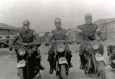 City of Kingston
Photograph - Black and white, c.1942
This image shows motorbike despatch riders who were tasked with transporting intercepted Japanese communications from the wartime wireless receiving station established in Chesterville Road, Moorabbin to Queens Road, St Kilda where the Directorate of Naval Communications and the code-breaking unit called FRUMEL (Fleet Radio Unit - Melbourne) were housed. The despatch riders would travel every two hours, all day and night. The wireless receiving station was established in Moorabbin because it was considered an area free of significant electrical interference and was not too far afield from the Melbourne headquarters in Queens Road. Moorabbin was originally established as a rural market gardening community.A secret wartime wireless receiving station was established in March 1942 in Chesterville Road, Moorabbin. The station was established on requisitioned market garden properties, and soon housed WRAN (Women's Royal Australian Navy) personnel and up to 35 US Navy servicemen. The Navy personnel intercepted Japanese coded communications and then despatched these by motorbike riders to Queens Road, St Kilda where the Directorate of Naval Communications and the code-breaking unit called FRUMEL (Fleet Radio Unit - Melbourne) were housed. The information intercepted by the wireless receiving station helped shape the Allied response to Japan's advances in the Pacific. Declassified defence records show that this unprepossessing station handled some of World War II's most sensitive secrets, and the despatch riders were a familiar sight in the Moorabbin area, though few were aware of their purpose. Black and white image of three men in uniform sitting astride three motorcycles in front of cars and buildings. The rider on the right is Jack Barker a local resident. Handwritten in red ink: A 602 / 90% Handwritten in blue ink: SW / 950301111 Handwritten in grey pencil: A 34 CHAP 6 / Spy basemoorabbin, despatch riders, wireless receiving station, world war ii, frumel (fleet radio unit - melbourne) -
Nhill & District Historical Society Inc.
Booklet - Back to Nhill and District 1964, souvenir booklet
Contains historical information about the progress of business and the people who helped make Nhill & District what it is. Back to Nhill and District 1964, souvenir booklet; 80 pages of local history. the stiff card cover is printed in pink/brown tones, with blue title.back to nhill, 1964, reunion, nhill & district - history