Showing 1029 items
matching trail
-
 National Vietnam Veterans Museum (NVVM)
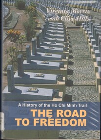
Book, Morris, Virginia, The Road to Freedom: A History of the Ho Chi Minh
The Ho Chi Minh Trail was a decisive factor in the defeat of American forces in the Vietnam War. At the peak of its 16 years' operation, the Trail ran through North and South Vietnam, Laos and Cambodia.The Ho Chi Minh Trail was a decisive factor in the defeat of American forces in the Vietnam War. At the peak of its 16 years' operation, the Trail ran through North and South Vietnam, Laos and Cambodia.vietnam war, 1961-1975 - transportation, ho chi minh trail -
 National Vietnam Veterans Museum (NVVM)
Book, 5 Ho Chi Minh Trails (Copy 2), 2012
ho chi minh trail, vietnam war (1961-1975) -
 National Vietnam Veterans Museum (NVVM)
Book, Plaster, John L, Secret commandos: Behind Enemy Lines with the Elite Warriors of SOG
SOG played an important role furing our operations against the communist enemy in Vietnam.SOG played an important role furing our operations against the communist enemy in Vietnam.vietnam war, 1961-1975 - commando operations - united states, sog, ho chi, ho chi minh trail, commandos, communist -
 Victorian Aboriginal Corporation for Languages
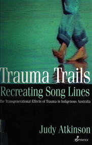
Book, Judy Atkinson, Trauma trails, recreating song lines : the transgenerational effects of trauma in Indigenous Australia, 2002
Deals with the healing from colonial dispossession and the trauma caused Indigenous people by drug abuse, alcoholism and various forms of abuse. The creation of change and healing through personal stories.jiman, bundjalung, psychological trauma, psychology, indigenous mental health, spiritual healing -
Whitehorse Historical Society Inc.
Letter - Correspondence, Yarran Dheran, 17/01/1979 12:00:00 AM
Letter from Yarran Dheran Committee of Management to Town Clerk, Nunawading 17/1/1979.Letter from Yarran Dheran Committee of Management to Town Clerk, Nunawading 17/1/1979 regarding walking and bicycle tracks between Schwerkolt Cottage and Yarran Dheran. With letter from Ann Creber to George Cox regarding meeting on the subject.Letter from Yarran Dheran Committee of Management to Town Clerk, Nunawading 17/1/1979.yarran dheran, parks and reserves, schwerkolt cottage, walking trails, bicycle paths -
Whitehorse Historical Society Inc.
Pamphlet, Go Bush in Nunawading, c1986
Bushland parks in the city of Nunawading.Bushland parks in the city of Nunawading. A leaflet with names, location and native plant descriptions.Bushland parks in the city of Nunawading. city of nunawading. parks and recreation, parks and reserves, horticultural centre forest hill, schwerkolt cottage, native plants, campbells croft, abbey walk vermont, blackburn south recreation trail, blackburn creeklands, wandinong sanctuary, blackburn lake sanctuary, cootamundra walk, r. e. gray reserve, yarran dheran, antonio park mitcham -
 Whitehorse Historical Society Inc.
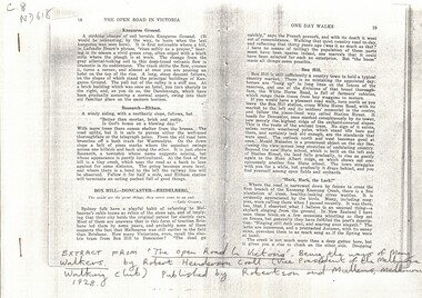
Article, The Open Road, 1928
'The Open road to Victoria', by Robert Henderson Croll, Melbourne: Robertson & Mullens, 1928.Photocopied extract from 'The Open road to Victoria', by Robert Henderson Croll, Melbourne: Robertson & Mullens, 1928. pp 18 - 24 describing one day walks in the eastern suburbs.'The Open road to Victoria', by Robert Henderson Croll, Melbourne: Robertson & Mullens, 1928.vermont, walking trails, canterbury road, box hill -
Whitehorse Historical Society Inc.
Document, Walking in Whitehorse, 2003
Pamphlet detailing ten walks in the municipality.Pamphlet detailing ten walks in the municipality.Pamphlet detailing ten walks in the municipality.walking trails, city of whitehorse -
Whitehorse Historical Society Inc.
Document, Walking in Whitehorse, 2006
Pamphlet describing walks in the City of Whitehorse [Rev. ed]Pamphlet describing walks in the City of Whitehorse [Rev. ed]Pamphlet describing walks in the City of Whitehorse [Rev. ed]city of whitehorse, walking trails -
Whitehorse Historical Society Inc.
Map, Pocket guide to walking and wheeling in Whitehorse, 2008
Map showing walks, cycle tracks and off lead areas for dogs in Whitehorse.Map showing walks, cycle tracks and off lead areas for dogs in Whitehorse. Includes walking and cycling groups.Map showing walks, cycle tracks and off lead areas for dogs in Whitehorse. walking trails, bicycle paths, city of whitehorse -
Whitehorse Historical Society Inc.
Pamphlet, Walking and wheeling in Whitehorse, 2009
A Guide to great walks in Whitehorse.A Guide to great walks in Whitehorse.A Guide to great walks in Whitehorse.city of whitehorse, walking trails -
 Whitehorse Historical Society Inc.
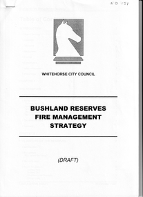
Document - Report, Bushland Reserves fire management strategy, 20/10/1997 12:00:00 AM
Draft Report on the fire managementDraft Report on the fire management strategy for bushland reserves by Whitehorse City Council. 20 October 1997. 45 pagesDraft Report on the fire management bushfire prevention, city of whitehorse, antonio park, mitcham, bellbird dell, blackburn lake sanctuary, hale property, heatherdale reserve, stephens reserve, somers trail, trove park, yarran dheran, r e gray reserve -
 Whitehorse Historical Society Inc.
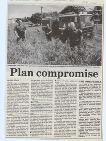
Article, Plan compromise, 12/11/1997 12:00:00 AM
Whitehorse Council has reached a compromise in draft strategyWhitehorse Council has reached a compromise in draft strategy for fire management in bushland reserves.Whitehorse Council has reached a compromise in draft strategy antonio park, mitcham, bellbird dell, blackburn lake sanctuary, yarran dheran, abbey walk, vermont, blacks walk, cootamundra walk, elgar park, heatherdale reserve, stephens reserve, mullum mullum creek, furness park, campbells croft, gardiners creek, surrey park, memorial park, somers trail -
 Ballarat Heritage Services
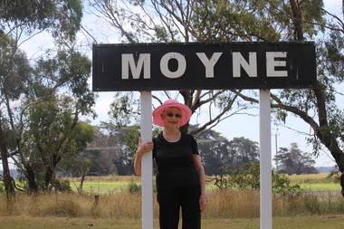
Digital photographs, L.J. Gervasoni, Moyne Station, 2016
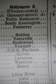
Digital imagesmoyne, railway, moyne railway siding, moyne railway station, transport, rail trail -
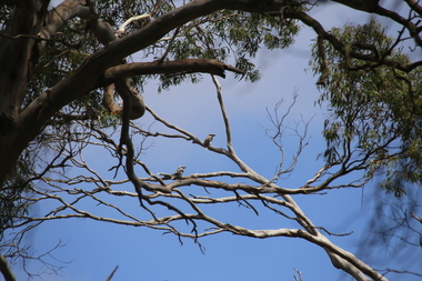 Ballarat Heritage Services
Digital photographs, L.J. Gervasoni, Moyne Station - birds, 2016
Digital imagesmoyne, railway, moyne railway siding, moyne railway station, transport, rail trail, trees, birds, kookaburras, wagtail -
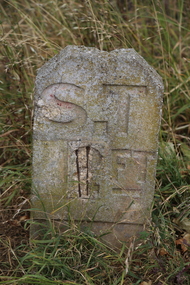 Ballarat Heritage Services
Digital photographs, L.J. Gervasoni, Marker - Koroit Railway Station, 2016
Digital imagestransport, rail trail, koroit, koroit railway station, stone marker, stone, marker, roadside, verge -
 Ballarat Heritage Services
Digital photographs, L.J. Gervasoni, Koroit Railway Station, 2016
Digital imagestransport, rail trail, koroit, koroit railway station, timetable -
 Ballarat Heritage Services
Digital photographs, L.J. Gervasoni, Koroit Railway Station, 2016
Digital imagestransport, rail trail, koroit, koroit railway station -
 Ballarat Heritage Services
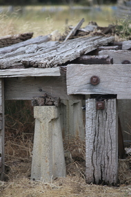
Digital photographs, Koroit Railway Station Goods Shed and Siding, 2016
Digital images of remnant railway items at the former Koroit Railway Station. transport, rail trail, koroit, koroit railway station, goods shed, siding -
 Ballarat Heritage Services
Digital photographs, L.J. Gervasoni, Koroit Railway Station, 2016
Digital imagestransport, rail trail, koroit, koroit railway station, goods shed, siding, metal, nails -
 Ballarat Heritage Services
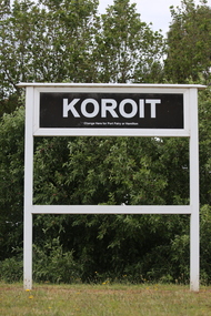
Photograph - Digital photographs, L.J. Gervasoni, Koroit Railway Station, 2016
Koroit is a town in Western Victoria.Digital images of a railway sign for Koroittransport, rail trail, koroit, koroit railway station, sign -
 Ballarat Heritage Services
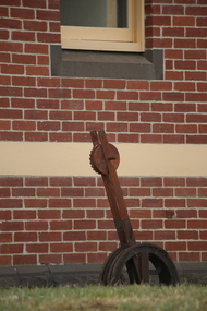
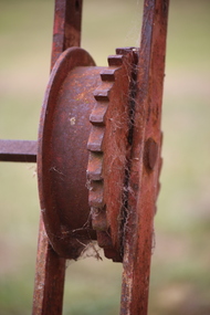
Photograph - Digital photographs, L.J. Gervasoni, Koroit Railway Station, 2016
Digital images of rusty railway infrastructure at Koroit Railway Station.transport, rail trail, koroit, koroit railway station, sign, wood, equipment, stairs, switch, rust -
 Ballarat Heritage Services
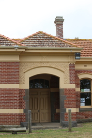
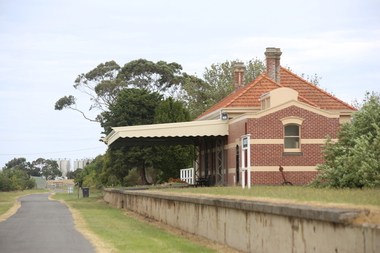
Digital photographs, L.J. Gervasoni, Former Koroit Railway Station, 2016
Digital images of a brick railway station at Koroit, Victoria. transport, rail trail, koroit, koroit railway station, buildings -
 Ballarat Heritage Services
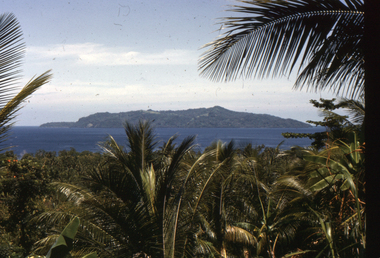
Slide, Dorothy Wickham, Scene, Papua New Guinea, 1958
The Kokoda Trail or track is a place of historic significance to many Australians. It is outside Australia in Papua New Guinea.Scanned from a coloured slideView from this sidepapua new guinea, papuan, scene -
 Whitehorse Historical Society Inc.
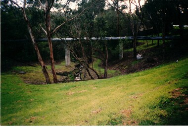
Photograph, Deep Creek Walking Trails, 28/11/1984 12:00:00 AM
Four coloured photographs of various views along walking track near Deep Creek Mitchamwalking trails, deep creek -
 Tramways/East Melbourne RSL Sub Branch - RSL Victoria Listing id: 27511
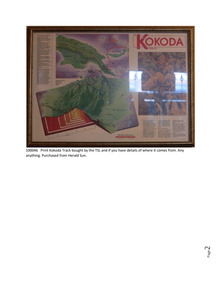
Memorabilia - Print Title Print Other Identifiers No identifiers Media No Attached Media Description Physical Description Framed print from 'The Australian' giving information around the Kokoda Trail, Kokoda Track Information Print
Historic articlePrinted copy of an article from the Print Title Print Other Identifiers No identifiers Media No Attached Media Description Physical Description Framed print fromaustralian kokoda campaign in wwll -
Moorabbin Air Museum
Document (Item) - Trailing Edge pressures on 80in wing extensions, Jindivik
-
Moorabbin Air Museum
Drawing (Item) - CAC 04-14116 Rib Assembly STA 182 Trailing Edge
-
Moorabbin Air Museum
Document (Item) - NPL Report No 5310 The effect of curvature of surface and thickness of trailing edge on Aileron Hinge Moments
-
Moorabbin Air Museum
Drawing (Item) - Trailing Aerial Weight Y12973, 12973-1, -2 and -3 for A73 and A89