Showing 1137 items
matching waterways
-
 Lakes Entrance Regional Historical Society (operating as Lakes Entrance History Centre & Museum)
Photograph, 1975
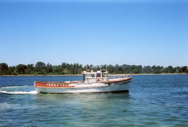
... Waterways ...Colour photograph of the fishing boat Pamela Star in Cunninghame Arm, vegetation on sand hummocks in background, Lakes Entrance Victoriafishing industry, boats and boating, fish, waterways -
 Lakes Entrance Regional Historical Society (operating as Lakes Entrance History Centre & Museum)
Photograph, 1975
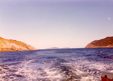
... Waterways ...Also second photograph similar unknown location in Bass Strait.Colour photograph of rugged coastline in Bass Strait, taken from fishing boat Minawie. Victoriawaterways, topography, aerial photograph, islands -
 Lakes Entrance Regional Historical Society (operating as Lakes Entrance History Centre & Museum)
Photograph, 1997
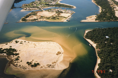
... Waterways ...Date made 7 July 1997Colour photograph being an aerial view of entrance at Lakes Entrance, showing the sand hummocks, the sand bar offshore a fishing boat entering the channel through the bar which appears to be recently dredged township of Lakes Entrance Victoriafishing industry, waterways, islands, boats and boating -
 Lakes Entrance Regional Historical Society (operating as Lakes Entrance History Centre & Museum)
Postcard, H D Bulmer, 1930 c
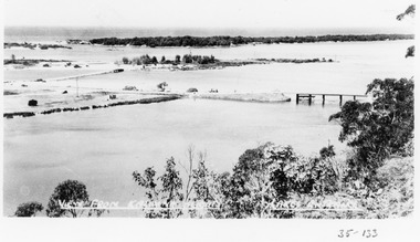
... Waterways ...Black and white postcard showing part of Princes Highway below Jemmys Point, undeveloped Bullock Island New Works area and Entrance in distance Lakes Entrance VictoriaLakes Entrance Gippsland Lakesroads and streets, transport, township, waterways -
Lakes Entrance Regional Historical Society (operating as Lakes Entrance History Centre & Museum)
Photograph, 1920 Easter
... Waterways ...Also a copy of image enlarged number 04225.1 size 10 x 15 cm donated by Marion HoldingBlack and white photograph taken top of steps leading down from Flagstaff to Eastern Pier walkway two women on steps, crane on end of Western Pier Lakes Entrance Victoriabowls club, topography, township, waterways -
Lakes Entrance Regional Historical Society (operating as Lakes Entrance History Centre & Museum)
Postcard, 1920 c
... Waterways ...Sepia toned postcard showing Eastern Pier, crane on end of pier, glimpse of Western Pier through timber of Eastern Pier Lakes Entrance Victoriabridges, roads and streets, transport, waterways -
Lakes Entrance Regional Historical Society (operating as Lakes Entrance History Centre & Museum)
Postcard, The Rose series p10854, 1940 c
... Waterways ...Also a second copy of same postcard in Spares boxBlack and white postcard of boats moored at the Quay Lakes Entrance VictoriaThe Quay Lakes Entrance Vicbusinesses, boats and boating, restaurant, waterways -
Lakes Entrance Regional Historical Society (operating as Lakes Entrance History Centre & Museum)
Photograph, Lakes Post Newspaper, 1/06/1992 12:00:00 AM
... Waterways ...Peter Brew Nurseryman and grower of subtropical plantsBlack and white photograph showing guest speaker Peter Brew from Bombala with Alan Broughton of East Gippsland Organic Agriculture Association at Organic Filed Day at Goldsmiths in Forest Lakes Entrance Victoriacatchments, environment, management, waterways -
Lakes Entrance Regional Historical Society (operating as Lakes Entrance History Centre & Museum)
Photograph, 1926 c
... Waterways ...Black and white photograph of a postcard showing crowd of guests standing at front of and on balcony of Broomes Federal Hotel Esplanade Lakes Entrance Victoriaaccommodation, boats and boating, jetties, waterways -
Lakes Entrance Regional Historical Society (operating as Lakes Entrance History Centre & Museum)
Photograph, 1/06/1999 12:00:00 AM
... Waterways ...Also a colour photograph looking South from Punt Road Metung 04460.1 10 x 15 cmColour photograph looking Northwest from Punt Road Metung Victoriatownship, waterways, boats and boating, boardwalk -
Lakes Entrance Regional Historical Society (operating as Lakes Entrance History Centre & Museum)
Photograph, 1991 c
... Waterways ...Also three colour photographs of Mitchell River at Bairnsdale taken autumn 1991 04605.1 04605.2 04605.3 10 x 15 cmColour photograph of Mitchell River taken from across the river looking back towards picnic area on right, site of old swimming pool below Court House Bairnsdale Victoriafarm, primary industry, settlement, waterways -
Lakes Entrance Regional Historical Society (operating as Lakes Entrance History Centre & Museum)
Photograph, 1940 c
... Waterways ...No 3 in series of fiveBlack and white photograph taken looking back from ocean side showing vegetation in background and workmen with shovels horses and scoops opening an entrance through sand at mouth of Snowy River Marlo Victoriaenvironment, people, public works, waterways -
Lakes Entrance Regional Historical Society (operating as Lakes Entrance History Centre & Museum)
Photograph, Caire, Nicholas John, 1905c
... Waterways ...turning on a central axis to allow the passage of river vessels. Image shows machinery for operation and the bridge closed to river traffic. Latrobe Wharf on the left bank is seen through bridge. Sale VictoriaBlack and white photograph of the Latrobe Bridge. This was a swing bridge over the Latrobe Riverbridges, waterways, civil engineering, jetties -
 Lakes Entrance Regional Historical Society (operating as Lakes Entrance History Centre & Museum)
Photograph, 1945c
... Waterways ...Black and white photograph of view from Kalimna Heights, showing part of the North Arm concrete bridge, Bullock Island and western side of entrance. Truck parked on approach to bridge. Lakes Entrance Victoriatopography, bridges, waterways, transport -
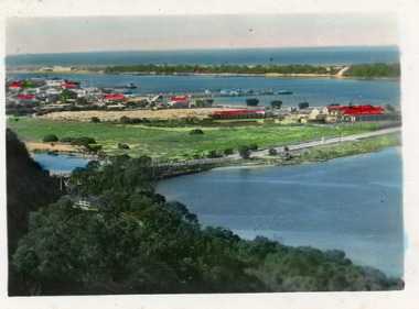
 Lakes Entrance Regional Historical Society (operating as Lakes Entrance History Centre & Museum)
Postcard, 1930c
... Waterways ...Black and white small format postcard showing the town, North Arm bridge, Cunninghame Arm, sand hummocks, taken from Mt Barkly / Jemmys Point. Lakes Entrance Victoriabridges, township, coast, waterways -
Lakes Entrance Regional Historical Society (operating as Lakes Entrance History Centre & Museum)
Postcard, Vogt Bairnsdale, 1920 c
... Waterways ...Note on back to Ella from her brother Don dated 1920Black and white postcard showing the old Swan Reach bridge over the Tambo River looking east. Buildings L to R Riverslea guesthouse and school with high pitched roof. Swan Reach VictoriaTambo River Swan Reachwaterways, boats and boating, township, guesthouses -
Lakes Entrance Regional Historical Society (operating as Lakes Entrance History Centre & Museum)
Photograph, John Flynn, 1906
... Waterways ...Bridge was built in 1896 and never finishedBlack and white photograph of bullock team pulling timber jinker with very long logs across the Buchan River beside the footbridge. Several men in charge of team and four girls on the hill, cottage and barn seen, bridge not finished Buchan VictoriaCrossing the Buchantransport, waterways, bridges, people -
Lakes Entrance Regional Historical Society (operating as Lakes Entrance History Centre & Museum)
Photograph, 1970 c
... Waterways ...This launch was first named Rubeena 1 became Peels Bellbird then renamed Rubeena Now at Port of Sale 2020Colour photograph of tourist launch Rubeena at Fishermans Landing Lake Tyers Victoriaboats and boating, tourism, waterways, local history -
Lakes Entrance Regional Historical Society (operating as Lakes Entrance History Centre & Museum)
Photograph, M Holding, 2006
... Waterways ...Also a colour postcard of fishing boats moored at eastern extension of Eastern Wharf Cunninghame Arm footbridge in background Inscription Some of the Fishing fleet at the Fish Wharf Lakes Entrance Vic 04262.1 10 x 15 cmColour photograph of unloading area Eastern Wharf showing boats moored and vehicles parked on loading bay Lakes Entrance Victoriaboats and boating, boardwalk, township, waterways -
Lakes Entrance Regional Historical Society (operating as Lakes Entrance History Centre & Museum)
Photograph
... Waterways ...Black and white photograph of fishing boat "Minataur" wrecked on beach opposite Lakes Entranceboats and boating, waterways, fishing industry, shipwrecks -
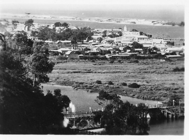
 Lakes Entrance Regional Historical Society (operating as Lakes Entrance History Centre & Museum)
Postcard - Township, 1998c
... Waterways ...Tinted small format postcard showing the township situated on the isthmus between two stretches of water the Cunninghame Arm and the North Arm. Work in progress widening the North Arm Bridge as seen by workmen's huts beside the southern approach. Lakes Entrance Victoriajetties, waterways, topography, township -
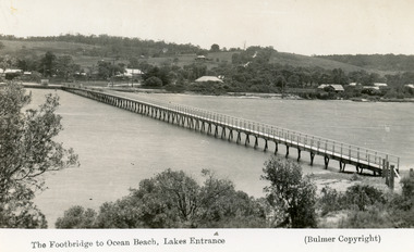 Lakes Entrance Regional Historical Society (operating as Lakes Entrance History Centre & Museum)
Postcard - Footbridge, 1937c
... Waterways ...Copies as follows|One Miniture postcard tinted 6.5 x 9|One Black and white copy 6.5 x 11|One Tinted copy 20 x 28|One Postcard 17 x 12Black and white postcard showing waterfront, some buildings along esplanade, no buildings on Myer St Hill. Footbridge across Cunninghame Arm completed to high tide mark, ramp constructed later, scrub in foreground. Lakes Entrance VictoriaThe Footbridge to Ocean Beach Lakes Entrancevegetation, bridges, waterways, township -
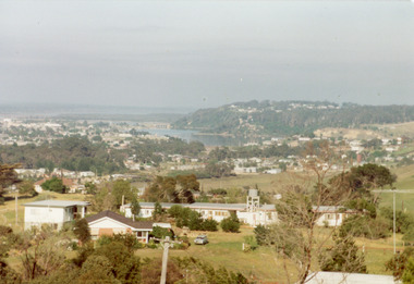 Lakes Entrance Regional Historical Society (operating as Lakes Entrance History Centre & Museum)
Photograph - Township, Fish, Marie, 1985c
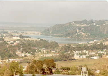
... Waterways ...Colour photograph of township, showing buildings, Jemmys Point, Mount Barkly, Kalimna Heights, North Arm and old North Arm bridge, and Rigby Island beyond. Sea Vista flats in foreground. Photo taken from near Telecom Tower on Merrangbaur Hill. Lakes Entrance Victoriatopography, township, waterways, bridges -
 Lakes Entrance Regional Historical Society (operating as Lakes Entrance History Centre & Museum)
Photograph - Township, Fish, Marie, 1985c
... Waterways ...Colour photograph of part of township showing Jemmys Point, Mount Barkly, Kalimna Heights, North Arm & old North Arm bridge, looking beyond to Rigby Island. Photo taken from near Telecom Tower on Merrangbaur Hill. Lakes Entrance Victoriatopography, township, waterways, bridges -
 Lakes Entrance Regional Historical Society (operating as Lakes Entrance History Centre & Museum)
Photograph - Township
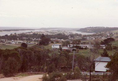
... Waterways ...Colour photograph of township of Lakes Entrance showing North Arm, North Arm Bridge, Jemmys Point, Mount Barclay, Kalimna Heights, Cunningham Arm and sand dunes on left. Looking west to Bullock Island and Rigby Island. Photo taken from near Telecom Tower on Merrangbaur Hill. Lakes Entrance Victoria bridges, waterways, islands, township -
 Lakes Entrance Regional Historical Society (operating as Lakes Entrance History Centre & Museum)
Photograph - North Arm Lakes Entrance, M Holding, 2008
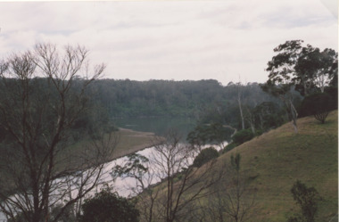
... Waterways ...Also two other colour photographs taken from Holding property showing twists and turns of North Arm number 03862.1 and 03862.2 sizes 10 x 15 cmColour photograph of North Arm views from D and K Holdings property Hunters Lane looking NNE Lakes Entrance Victoria people, tourism, waterways, lakes entrance -
 Lakes Entrance Regional Historical Society (operating as Lakes Entrance History Centre & Museum)
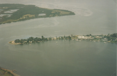
Photograph - Metung, Gippsland Ports, 2006 c
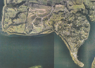
... Waterways ...Colour aerial photograph showing Shaving Point at Metung including Chinamans Creek at the right housing subdivisions of Kingscove Estate Tambo Bluff Estate and Lake King on Gippsland Lakes Victoriaaerial photograph, topography, waterways, metung -
 Lakes Entrance Regional Historical Society (operating as Lakes Entrance History Centre & Museum)
Photograph - Metung, 1995 c
... Waterways ...Colour aerial photograph of Shaving Point Gippsland Lakes with Mosquito Point bottom left hand corner Boole Poole on opposite shore Metung Victoriaaerial photograph, waterways, topography, metung -
 Lakes Entrance Regional Historical Society (operating as Lakes Entrance History Centre & Museum)
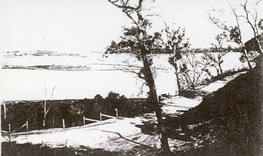
Photograph - The Entrance, 1910c
... Waterways ...Black and white photograph of the Princes Highway at Kalimna. It shows the road around Jemmys Point. Bullock Island and a distant view of the man made entrance. Gumtrees along roadside. Lakes Entrance VictoriaThe Entrance from Princes Highwayroads and streets, vegetation, fences, waterways -
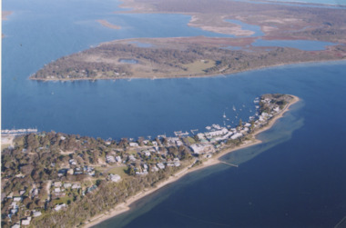 Lakes Entrance Regional Historical Society (operating as Lakes Entrance History Centre & Museum)
Photograph - Metung, 2005 c
... Waterways ...Colour aerial photograph of Shaving Point Gippsland Lakes looking eastward over Mosquito Point Bancroft Bay in between Metung Victoriaaerial photograph, settlement, waterways, metung