Showing 64719 items
matching henderson-house
-
 Bendigo Historical Society Inc.
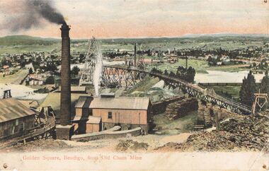
Postcard - GOLDEN SQUARE, BENDIGO FROM ' OLD CHUM' MINE
Postcard: hand coloured image showing mine site in Golden Square. Brick chimney in foreground, sheds. Tramway from LH side to poppet head behind chimney. On back of card ' Post GWW Card' Printed partly in Great Britain and partly in Germany. In black ink ' Dear Muncie Bob, I hope you arrived all right. I suppose you have started work before this. I don't start till 10th. Feb.' A stamp has been drawn, showing a house and written ' little house on the hill' Dated 1913.G.W.W.bendigo, mining, old chum mine, golden square, old chum mine, golden square, postcard -
 Southern Sherbrooke Historical Society Inc.
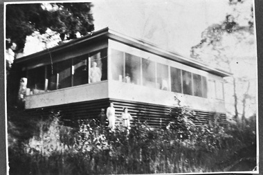
Photograph - Smith family holiday house on Park Drive, Belgrave, c.1940s
Black and white photo of the Smith family house on Park Drive just past Belgrave Lake Park. The House appears to have an enclosed verandah. A man, possibly Oscar Smith, is looking out of the window and a second person, possibly Pam Harris's sister, is also looking out. Below them, two young people, a boy and a smaller girl, are standing in the garden. This was possibly the caretaker's place. '1627' is stamped on the back of the photo. The photo probably dates to the 1940s and is part of a collection of family photos donated by Pam Harris, Shire of Sherbrooke President, 1982-1983 & 1987-1988. -
 Ballarat Tramway Museum
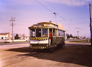
Photograph - Digital image Set of 6, W. J. Llewelyn, c1970
Set of six Digital images of All by Chris Phillips. c1970 .1 - No. 30 at Sebastopol terminus showing Lydiard St Nth destination with a lady standing in the front door. Has a Pay as you enter sign. Shows the houses behind the tram in Albert St. .2 - No. 30 leaving the terminus with the hotel and house in the background. .3 - view from inside the tram, looking back along the track towards the terminus. Shows the nature of the Albert St at the time. .4 - No. 30 with Chris Phillips boarding the tram. .5 and .6 - single trucker at dusk with all the lights on.trams, tramways, sebastopol, albert st, night photo, tram 30 -
 Kew Historical Society Inc
Plan - Subdivision Plan, J R Mathers & McMillan, Myrtle Hill Estate, East Kew, circa 1949, c.1949
The Kew Historical Society's map collection includes a substantial number of real estate subdivision plans, mainly of Kew but also of surrounding suburbs in Melbourne. Most of the subdivision plans date from the 1920s and 1930s when the districts old homes and local farmland were being split up to accommodate residential growth in the postwar period. These early plans were assembled by a local firm, Jas R Mather & McMillan, which had an office in Cotham Road. Many of the plans, and sometimes photos, were annotated by the agents.Subdivision plans are historically important documents used as evidence for the growth of suburbs in Australia. They frequently provide information about when the land was sold as well as evidence relating to surveyors and real estate and financial agents. The numerous subdivision plans in the Kew Historical Society's collection represent working documents, ranging from the initial sketches made in planning a subdivision to printed plans on which auctioneers or agents listed the prices for which individual lots were sold. In a number of cases, the reverse of a subdivision plan in the collection includes a photograph of a house that was also for sale by the agent. These photographs provide significant heritage information relating house design and decoration, fencing and household gardens.The photograph may also be aesthetically significant depending on the importance of the photographic atelier.Myrtle Hill, at 14 Vista Avenue, Kew, is of local historical and architectural significance as a good example of a large and imposing single-storey Italianate house of the early 1870s surviving in Kew. Originally sited on a large allotment overlooking Normanby Road, the setting of the house has been dramatically altered through extensive subdivision and development. The subdivision plan of the ‘Myrtle Hill Estate’ indicates that in one such subdivision, 11 allotments were created fronting Bowyer Avenue, Myrtle Avenue, and Normanby Road. The outline and building profile of Myrtle Hill is shown on the west side of Bowyer Avenue.The full (typed) title of this subdivision plan is :"Plan of SUBDIVISION of part of CROWN PORTION 83. / at KEW / PARISH OF BOROONDARA. / COUNTY OF BOURKE". / "MYRTLE HILL ESTATE / EAST KEW" In addition to the Title and subtitle, the plan also lists the advantages of the subdivision. -
 Kew Historical Society Inc
Slide - 'Burke Hall', Nolan Avenue, 1976
Colour transparency (slide) created in June 1976 during a tour by the Junior National Trust, which was led by members of Kew Historical Society. The collection of 21 slides reveals that the tour covered all parts of Kew, but focused understandably on heritage buildings and sites.Image of an historic place in Kew that can be dated to an exact time and place. The images, albeit amateurish in composition, frequently reveal aspects of important buildings and sites that have changed over time.35mm colour transparency of Burke Hall (formerly Studley House, Waverley) showing the front facade facing south away from Nolan Avenue and Studley Park Road. Now Xavier Junior School, the Victorian Heritage Register describes the building as: "...a largely intact mansion commenced in the mid-Victorian period that was sympathetically added to during the nineteenth century and as such, is one of the key Victorian buildings to have been built in Kew. the historical associations with figures such as Charles C. Staples and Carl Pinschof enhance the significance, while the additions made to the house in recent years detract from it."historic houses -- kew (vic.), nolan avenue -- kew (vic), xavier college -- kew (vic.), burke hall, waverley, studley hall -
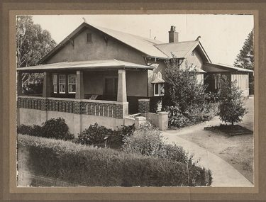 Bendigo Historical Society Inc.
Photograph - T C WATTS & SON COLLECTION: RODNEY STREET, BENDIGO, 1930
Frederick Steele Ferguson (1861-1938) married Beatrice O'Brien in 1898. Originally they lived at 19 Brodie Street, Quarry Hill, but by 1925 they were registered as living on the corner of Rodney and Reginald Street with their son Frederick Steele McNair Ferguson and his wife Amelia, and later with their daughter Maude. It appears the family continued to live at this address following Frederick snrs death. Frederick and his son Frederick jnr were wool merchants.Black and white photograph mounted on rectangular brown board. House, weatherboard and rough cast, verandah with brick balustrade and rough cast pillars, corrugated iron roof, 1 chimney with 2 pots, double front door, small bay window at RH side, bay window under verandah, sleepout/sunroom attached at back right, established garden, concrete path, hedge at front, woven crinkled wire fence. On back of photo' F. Ferguson, £1800 corner Rodney and Reginald Streets, 15.4.30 corner Rodney and Reginald Streets. 2012 photo of house attached to record.Frank A. Jeffree Bendigobendigo, business, t c watts & son -
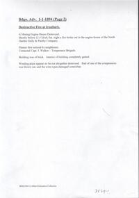 Bendigo Historical Society Inc.
Document - NORTH GARDEN GULLY PASSBY COMPANY - DESTRUCTIVE FIRE AT IRONBARK, NORTH GARDEN GULLY & PASSBY COY
Handwritten notes and typed copy of same, on a fire at Ironbark. From the Bendigo Advertiser 1/1/1894 (Page 2). Destructive Fire at Ironbark. A Mining Engine House Destroyed. Shortly before 12 o'clock Sat. night a fire broke out in the engine-house of the North Garden Gully & Passby Company. Flames first noticed by neighbours. Contacted Capt. J Walker - Temperance Brigade. Building was of brick. Interior of building completely gutted. Winding plant appears to be not altogether destroyed. End of one of the compressors was blown out, and the wire ropes damaged somewhat. Albert Richardson Collection. document, gold, north garden gully & passby company, north garden gully & passby company, bendigo advertiser 1/1/1894 page 2, capt j walker, temperance brigade -
 Glen Eira Historical Society
Photograph - Kilwinning, Balaclava Road
A colour photograph (101mm x 149mm) of the exterior of the house Kilwinning at Balaclava Road circa 1960. The file also includes two colour photocopies of a photograph (190mm x 239mm) of the exterior of Kilwinning showing the driveway and the garden in full bloom. A handwritten note on one of the copies provides that the house was demolished in 1965.kilwinning, balaclava road, davies j, house names, houses, architectural features, gardens, caulfield, st kilda east -
 Glen Eira Historical Society
Document - Lincoln, Clarence Street, 33, Elsternwick
Photo copy of extract from caulfield Conservation study of “Lincoln” formerly “Kiora” (1913) 33 Clarence Street caulfield, conducted by Andrew Ward in October 1994. This was one of four houses built by architect A.J.Smith in the 1880s. A brief history of the house and a description of the architectural features included. One exterior photograph.caulfield, clarence street, kiora, lincoln, kooyong park, estate, gladstone parade, kooyong road, gudgeon wilfred, hume mrs, hume thomas, emmerson mary, emmerson joseph, finlay a. mrs, harper jessie -
Glen Eira Historical Society
Article - Archibald Street,|1,|Elsternwick
Newspaper article on forthcoming sale of 1 Archibald St, Elsternwick, includes one coloured photograph. Gives brief description of interior features. Newspaper article on forthcoming sale of 1 Archibald St, Elsternwick, includes one coloured photograph. Article describes house interior and details of house exterior and outbuildings.archibald street, elsternwick, victorian style, architectural features, rogers mark, kelly juanita, italianate style, nicholson ceramics, buxton, estate agent, outbuildings -
Glen Eira Historical Society
Document - Cavers Carre
Three articles about Cavers Carre. Handwritten document giving details of the location of the house. Built c.1866 and demolished prior to 1905 when the block was subdivided. No details of the house. Two plans of Gardenvale and Riddell Estate dated 29/11/1884 and unknown from State Library Victoria records.gardenvale estate, glen huntly road, riddell estate, melbourne and brighton railway, mcmillan street, orrong road, archibald street, rowan street, hamilton street, downshire road, shoobra road, madden walter, tuxen august, fraser and co., surveyors, muntz and muntz, cavers carre, elsternwick, stanley street, carre street, railway cresent, riddell parade, riddell john carre, land subdivisions -
 Greensborough Historical Society
Photograph - Digital image, John McLaughlin's Eltham farm, 1934, 1934_
Part of a collection of photographs owned by Dorris McLaughlin who was born in Greensborough, in 1899 to John McLaughlin and Rosalie Ellen Whatmough. The collection contains photographs of friends and relatives from the Greensborough and Eltham areas. This photograph shows a view of John McLaughlin's Eltham farm house. The McLaughlin family never lived in this house.Digital copy of black and white photograph.dorris mclaughlin, john mclaughlin -
 Linton and District Historical Society Inc
Plate, Dinner Plate, Pinder, Bourne & Co., Staffordshire
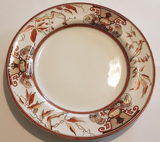
It is understood that the plate was used by Samuel Lewers and his family when they lived at Traquair House (1861-1895). The plate was given by Stella Surman, who lived at Traquair House in the 1960s and 1970s, to her foster son Graeme Dunn. Marks on the plate indicate it was manufactured by Pinder, Bourne & Co in Staffordshire, England.Round dinner plate, white in centre, 5cm wide decorative border (hand-painted?), images in "Chinese" style depict leaves, vases & medallions, in colours orange-red, brown, & black. On back of plate: Maker's mark consists of laurel & crown, with the letters "PB & Co"and the name of pattern, "Tycoon". Manufacturer's name PINDER, BOURNE & CO. also imprinted on back of plate. Also hand-painted in small lettering on back: "9197 / ' ' ' ".dinner plates, crockery, pinder bourne & co [staffordshire potteries], traquair house, lewers family, stella surman, graeme dunn -
 Melbourne Tram Museum
Photograph - Copy - Cable tram at Rathdowne St car house or depot, c1900
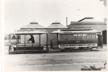
Copy photograph (based on the photo corners on the right-hand side) of a cable set outside the Rathdowne St or North Carlton line, car house. Trailer No. 57, lettered "St Kilda Beach and North Carlton" Has the grip man and conductor standing in their positions. The photo shows the construction of the car house.Yields information about the Rathdowne St car house and a cable set on the North Carlton line.Black and white copy photograph, plain back.tramways, cable trams, tram 57, north carlton, rathdowne st -
 Melbourne Tram Museum
Financial record, Melbourne Tramways Trust (MTT), "Cable tramways construction Cost", c1900
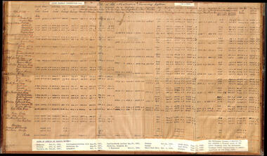
Item prepared to provide the cost of construction for each cable tram line, length, track drainage, alterations to services, engine houses, engine house machinery, engineering, total costs, cost per mile, with a typed list of line opening dates and the lease to MTOCo from the Melbourne Tramways Trust (MTT).Yields information about the cost of construction of the cable tramways by the MTT.Hand made sheet with typed lables prepared in ink titled "Cable tramways construction Cost", mounted onto a masonite sheet with adhesive tape on the sides.tramcars, tramways, costs, cable trams, tramway construction, engine houses, mtt, melbourne tramways trust -
 Orbost & District Historical Society
book, Orbost Golf Club, 2006
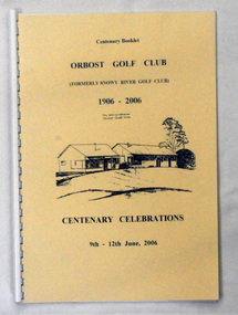
This book was produced as part of the centenary celebrations in 2006. In 2006 Orbost Golf Club celebrated its’ Centenary having originally been formed as the Snowy River Golf Club and played on private land near the banks of the Snowy River just to the south of town. In the 1930’s the Golf Club relocated to its present site and was renamed Orbost Golf Club. The land was shared by the Show grounds and Racing Club. Orbost Golf Club later acquired the land outright to provide a permanent home for golfers in Orbost and surrounding district.This is a local history book.A 38 pp spiral bound book titled Orbost Golf Club Centenary Booklet 1906-2006 Centenary Celebrations 9/12 2006. The front cover is cream and has a black line sketch of the old club house at Orbost Golf Club.recreation orbost-golf-club -
 Bendigo Military Museum
Photograph - PHOTOGRAPH, FRAMED WW1, Wayne Eels, C.2008/2009
The Grinton Collection. The wedding of Jack Grintons younger Brother Fred and wife Lucy. Refer - Cat No. 1280 for Jacks service details.Photograph framed. Photograph - black and white photograph on paper depicting a semi-formal full-length portrait of a bride and groom. The bride is standing. Groom is seated. Background - house verandah. Frame - timber, light varnish finish, Perspex front, cardboard backing."Group 6: Life after 1919". "A. Fred Grinton and Lucy Sutherland". framed accessories, camera on the somme, ww1, 38th bn, grinton -
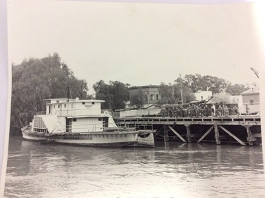 Port of Echuca
Black and white photograph, 1980? A note has been added by C.J (Claire Jackson) saying that the photo was taken about 1973-74
The photograph shows the state of the Echuca wharf in 1973 or 1974. The P.S Pevensey looks like it has just received a fresh coat of paint. There is also a train parked on the wharf behind the school students. The river also appears to be quite high. This photograph shows the state of the wharf in the early 1970's. It shows the fence between the wharf and Murray Esplande was relatively new. The tourism industry was very new to Echuca in the 1970's but the P.S Pevensey looks ready to take Tourists cruising on the Murray River. It also shows schools were using the port as a valuable resource for teaching History.A black and white photograph of the P.S Pevensey tied up to the Echuca Wharf. There is a group of school children leaning over the wire fence at the edge of the wharf. There is also one teacher supervising the children. The Steam Packet Inn and the Customs House can be seen in the background.Pevensey; Melbourne can be seen clearly written on the paddle steamer. On the back of the photograph is written "This photograph is with the compliments of the Ministry of Tourism, Government of Victoria. Please acknowledge photo; Michael Cheshire. There is also a purple Port of Echuca stamp on the back of the photograph.echuca wharf, p. s pevensey, ministry of tourism, cheshire, michael -
 Bendigo Military Museum
Mixed media - ARCHIVE BOX - GRINTON COLLECTION, Miss Jean Grinton, Photographs and Postcards - 1916 to 1919 and Folder c.2009
Items relate to Jack Grinton No 1043, 38th Batt AIF. The photographs were taken during and after WW1. The series of postcards, some of which are labelled, were collected by Grinton. Pictures of 38th Battalion soldiers are depicted on a number of postcards. Other photographs and postcards feature scenes from France and the UK. Part of the Grinton Collection which included hundreds of negatives and developed photos taken by Jack Grinton during WW1. See also 1290.2P and 1291.2P. Refer Cat No 1280 for Jacks service recordBlack three ringed plastic folder in a black plastic box. Folder is divided into labelled sections each of which contains a number of photographs or postcards. Photographs and post cards are housed in clear plastic pockets. A handwritten white label is taped to the spine of the box..1) Each section divider is labelled in blue ink: 'ADDITIONAL PHOTOS', 'PHOTOS WITH WRITING', POSTCARDS', SCHRAPNEL POSTCARDS', HEATHER'S CARDS'. .2) On spine label handwritten in blue ink: ' ADDITIONAL PHOTOS', PHOTOS WITH WRITING', POSTCARDS', SCHRAPNEL POSTCARDS', HEATHER'S CARDS', JEAN GRINTON'.38th battalion, postcards, photography - photographs, books - albums, grinton collection, western front -
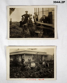 Bendigo Military Museum
Photograph - PHOTOGRAPHS WW1, 1916
Photos relate to James Worland MILLS No 3441 59th Battalion. James is the soldier in both photos. Refer Cat No 169P for his service details. .1) Photo post card, sepia, showing a group pf men & 1 soldier at a farm around a drive belt. .2) Photo, post card, black / white, showing a group of men, women, a child & a soldier in a vegetable garden with a house in the background. ..1) On rear in ink: “L B Mills Mincha” .2) On the front in red ink: “Findlay 1916”photographs, 59th -
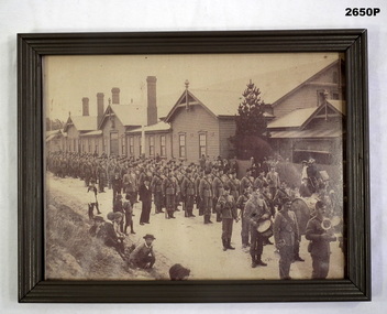 Bendigo Military Museum
Photograph - PHOTOGRAPH, FRAMED, c.1900's
Black & white photograph of soldiers in uniform on parade with military band in front. Parade of soldiers standing in front of timber building & house with picket fence. Children in foreground watching the parade. 1900's rectangular timber frame painted dark grey colour.photography-photographs, frame accessories, trades -carpentery, passchendaele barracks trust -
 Bendigo Military Museum
Mixed media - ARCHIVAL BOX - GRINTON COLLECTION, Miss Jean Grinton, Photographs and Ephemera 1916 - 1919 and Folder c. 2009
Items relate to Jack Grinton No 1043, 38th Batt AIF. The postcards document Grinton's visits to various UK, French and European sites of interest. The ephemera in the last section include booklets, sketches, souvenirs, programmes, paper money, photo wallets, letters, pay slips and Grinton's discharge certificate. Part of the Grinton Collection which included hundreds of negatives and developed photos taken by Jack Grinton during WW1. Refer Cat No 1280 for service details. See also 1291.2P and 4528.2P. Black three ringed plastic folder in a rectangular black plastic box. Folder is divided into labelled sections each of which contains a number of postcards and assorted ephemera. Postcards and ephemera are housed in clear plastic pockets. A handwritten label is taped to the spine of the box..1) Each section divider is labelled in blue ink: 'P/Cs CAPE TOWN', 'P/Cs ENGLAND & SCOTLAND', 'P/Cs FRANCE & EUROPE', 'ASSORTED EPHEMERA' .2) On spine label handwritten in blue ink: 'POSTCARDS - Sth AFRICA, UK, FRANCE, ASSORTED EPHEMERA, JEAN GRINTON'. 38th battalion, books - albums, western front, john 'jack' grinton, grinton collection -
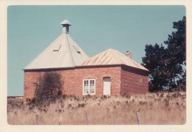 Phillip Island and District Historical Society Inc.
Photograph, 1960's
Donated by N. M. & J. D. Archibald, April 1973.Colour Photograph. Ventnor. Hurricane Hill (Richardson's Hill). Built about 1883. 18' x 18'. Brick double one story. Originally built for Mr. T. Richardson. Now being used as a holiday house (1973). Chicory Kiln Album.local history, photography, photographs, agriculture buildings, historic, chicory kiln, hurrican hill, home, richardson, ventnor, n & j archibald, richardson's hill ventnor phillip island -
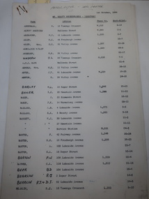 Kiewa Valley Historical Society
Papers - Mt Beauty Householders 1964, Mt Beauty Householders - Directory
Mt Beauty township was built in the late 1940s by the State Electricity Commission of Victoria for its workforce during the construction of the Kiewa Hydro Electric Scheme.This is a list of the early occupants of Mt Beauty township, naming the head of the household. It lists their phone numbers but not their occupations or family members.16 pages of Foolscap paper held by 2 staples in the top right hand corner. It consists of the following headings: - Name, Address, Phone No., and Sect-Allot.. The names are in alphabetical order. Commission owned houses are asterisked. All lists are as at 1st October, 1964Written in pen on top of first page "Patrol Supvr. - Info. Centre'mt beauty householders, mt beauty directory, mt beauty telephone directory, mt beauty residents 1964, mt beauty township -
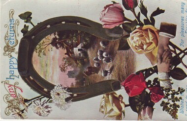 Streatham and District Historical Society
Post Card, Post Card WW1, Circa 1914-1919
World War 1 post card from Australia to a soldier overseas.This card demonstrates to relationships during this time and the artwork of the period.Rectangular paper card with a picture of hands reaching to touch between the stems of flowers. A horse shoe with a county scene of a house, sheep, horse and man walking down the road from a tall building. The colours are pink, red, yellow green brown and blue.On the front Medium font " Many Happy Returns across the top and in blue are font "Wishes true I send to you. For pleasures many Troubles few". Along the bottom edge. On the back written in fine ink the words "My Dear Little lovy Duck Bill wishing you a Happy Birthday. Hope you are all well remember me to all with love to you Gooby & my only one J.J. x xww1, art, post, card, greetings -
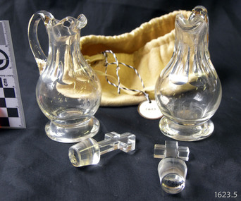 Flagstaff Hill Maritime Museum and Village
Cruets, Untitled
Cruets or Communion Jugs (2) cut glass used for religious ceremony. Lid features glass cross. Both containers have "IHS" engraved in the glass. One container has broken handle but has been repaired. Housed in a chamois drawstring pouchflagstaff hill, warrnambool, shipwrecked coast, flagstaff hill, flagstaff hill maritime museum, maritime museum, shipwreck coast, flagstaff hill maritime village, great ocean road, communion jugs, cruets -
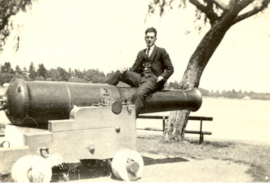 Federation University Historical Collection
Photograph, Vernon Holt, Frank Wright on the Canon at View Point, Lake Wendouree, 3/2/1922
Frank Wright was a renown resident of Smeaton, where he was born. He lived at Laura Villa, and attended Smeaton State School. His father William was a gold miner and his mother's name was Sarah. Their family won many singing and instrumental awards. Frank was tutored by Percy Code and was awarded a gold medal for the highest marks in the ALCM examinations in the British Colonies at the age of seventeen years. He became the Australian Open Cornet Champion by the age of eighteen. A year later, Frank conducted the City of Ballarat Band, and later the Ballarat Soldiers’ Memorial Band. He formed the Frank Wright Frisco Band and Frank Wright and his Coliseum Orchestra. These bands won many South Street awards, and Frank as conductor won many awards in the Australian Band Championship contest. In 1933 Frank Wright sailed to England to conduct the famous St Hilda’s Band and was later appointed Musical Director of the London County Council, where he organized many amazing concerts in parks, in and around the London district. He was made Professor of Brass and Military Band Scoring and conducted at the Guildhall of Music and Drama. Frank was often invited to adjudicate Brass Band Championships around Europe, in Australia, including South Street and in New Zealand. The Frank Wright Medal at the Royal South Street competition is awarded to an individual recognized as making an outstanding contribution to brass music in Australia.Black and white photograph of a man dressed in a three piece suit sitting on a canon which is located in a park overlooking a lake. Trees and houses can be seen on the other side of the lake. The man is Frank Wright and the place is "View Point", Lake Wendouree, Ballarat.Written in pen on back - Frank Wright - on canon at "View Point", Lake Wendouree, Ballarat. Photo by Vernon Holt 3/2/22frank wright, vernon holt, lake wendouree, ballarat, canon -
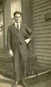 Federation University Historical Collection
Photograph - Black and White, Vernon Holt, Frank Wright outside 118 Doveton Street South, Ballarat, 1921, 23/7/1821
Frank Wright was a renown resident of Smeaton, where he was born on 2 August 1901. He lived at Laura Villa, and attended Smeaton State School. His father William was a gold miner and his mother's name was Sarah. Their family won many singing and instrumental awards. Frank was tutored by Percy Code and was awarded a gold medal for the highest marks in the ALCM examinations in the British Colonies at the age of seventeen years. He became the Australian Open Cornet Champion by the age of eighteen. A year later, Frank conducted the City of Ballarat Band, and later the Ballarat Soldiers’ Memorial Band. He formed the Frank Wright Frisco Band and Frank Wright and his Coliseum Orchestra. These bands won many South Street awards, and Frank as conductor won many awards in the Australian Band Championship contest. In 1933 Frank Wright sailed to England to conduct the famous St Hilda’s Band and was later appointed Musical Director of the London County Council, where he organized many amazing concerts in parks, in and around the London district. He was made Professor of Brass and Military Band Scoring and conducted at the Guildhall of Music and Drama. Frank was often invited to adjudicate Brass Band Championships around Europe, in Australia, including South Street and in New Zealand. The Frank Wright Medal at the Royal South Street competition is awarded to an individual recognized as making an outstanding contribution to brass music in Australia.Black and white photograph of a young man dressed in a dark three piece suit, with one hand resting on his hip. He is standing outside the bay window of a weatherboard house. The man is Frank Wright and the place is 118 Doveton Street South, Ballarat.Written in pen on the back - Frank Wright, at the age of 19 years, taken at 118 Doveton St. South, Ballarat, by Vernon Holt, 23-7-1921frank wright, vernon holt, 118 doveton st south, ballarat -
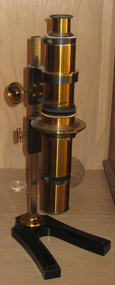 Federation University Historical Collection
Scientific Instrument, Calderon's Stauroscope, c1900 (?)
The stauroscope is an instrument for studying characteristic properties of anisotropic mineral particles. Later petrografic microscopes incorporate the stauroscope feature. Calderon Stauroscope in a hinged timber box. An optical device resembling a microscope with a vertical axes. The composite tube is made of brass, and is adjustabbly attached to a splayed-leg base equipped with a traingula section pillar. Instrument and accessoried housed in a brown polished timber box stauroscope, scientific instrument, microscope -
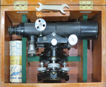 Federation University Historical Collection
Instrument - Scientific Instrument, Dumpy Level, 05/1950
Used for surveying classes at the Ballarat School of Mines.Telescope with cross hairs and stoidia wites. Internal focussing. Vertical tilt adjusted with vernier mocrometer screw mirror lid longitudinal bubble level. Pea bubble level on plate. Housed in wooden storage carry box. Fits tripod cat. no. 4118Serial number 67543 On box lid in white paing "L 6". In yellow paing "59". Inside box lid - Manufacturers label; grades table label, calibration label reading "instrument No 67 543, date 13.5.50" (ink faded) constant: +0.19 ft"dumpy, level, surveying, scientific instrument, e.r. watts & son ltd, ballarat school of mines