Showing 11045 items matching "lander"
-
 Whitehorse Historical Society Inc.
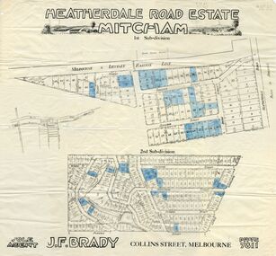
Document, Heatherdale Road Estate, Unknown
Third subdivision, Heatherdale Road Estate, Mitcham comprising 188 lots. Includes plans, price list and advertising material. 2 copies.brady, john f., heatherdale road, mitcham, purches street, kulnine avenue, culwell avenue, blossom street, nymph street, land subdivision, walwa street -
 Whitehorse Historical Society Inc.
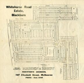
Document, Whitehorse Road Estate
Plan of blocks for sale on the Whitehorse Road EstatePlan of blocks for sale on the Whitehorse Road Estate, Blackburn. 2 copies.Plan of blocks for sale on the Whitehorse Road Estateland subdivision, whitehorse road estate, blackburn, springfield road, goodwin street, surrey road, esdale street, larch street, maple street, musk street, elder street, linden street, elm street, fir street, barnes estate -
 Whitehorse Historical Society Inc.
Document, Heatherdale Road Estate, ??
Plans of 1st and 2nd subdivision of Heatherdale Road estatePlans of 1st and 2nd subdivision of Heatherdale Road estate, Mitcham.Plans of 1st and 2nd subdivision of Heatherdale Road estateland subdivision, purches street, mitcham, northcote street, linlithgow street, denman street, fuller street, stanley grove, dudley street, munro street, irvine street, forster street, ferguson street, talbot street, heatherdale road -
Whitehorse Historical Society Inc.
Map, Austral Park, Mitcham, 1907
Advertisement for subdivision of area south of Mitcham Railway Station.Advertisement for subdivision of area south of Mitcham Railway Station. Includes area now site of Mitcham reservoir. Some details of main buildings in Mitcham and Vermont.Advertisement for subdivision of area south of Mitcham Railway Station. land subdivision, mitcham, mitcham road, mitcham, calcutta street, mitcham, delhi street, mitcham, meerut street, mitcham, simla street, mitcham, agra street, mitcham, lucknow street, mitcham, mitcham reservoir, austral park mitcham -
 Whitehorse Historical Society Inc.
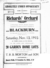
Legal record - Document, Richards' Orchard, 1/11/1915 12:00:00 AM
Estate Agent's advertisement for Richard's Orchard,Estate Agent's advertisement for Richard's Orchard, Main Street, BlackburnEstate Agent's advertisement for Richard's Orchard,richards orchard blackburn, main street, blackburn, land subdivision, t. r. b. morton & son -
Whitehorse Historical Society Inc.
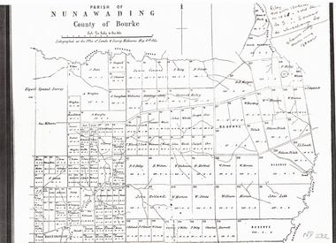
Map, Plan of the Parish of Nunawading, 1853
Photocopy of map showing names of selectors, also list of references to the corners of allotments.Photocopy of map showing names of selectors, also list of references to the corners of allotments. Note on verso:'Gardiners Creek, Ballyshanassey township surveyed by H. Parmein, Surveyor General's Office Nov 30, 1853 also Reference to the Corners of allotments' (Plan 428)Photocopy of map showing names of selectors, also list of references to the corners of allotments. land subdivision, gardiners creek, ballyshanassy, parmein, h, burwood east, maps -
Whitehorse Historical Society Inc.
Map, The Parish of Nunawading, 1853
Photocopy of manuscript plan with allotments numbered and some named.Photocopy of manuscript plan with allotments numbered and some named. Note on verso: The Parish of Nunawading in the County of Bourke; lithographed at the Surveyor General's office by J.Jones Jan 18th 1853. Endorsed Sale Plan 271. Dray tracks, water holes and terrain indicated.Photocopy of manuscript plan with allotments numbered and some named. land subdivision, maps, parish of nunawading, jones, j -
 Whitehorse Historical Society Inc.
Document, Plan of Parish of Nunawading, 01/05/1864
Copy of plan of Parish of NunawadingCopy of plan of Parish of Nunawading, County of Bourke, lithographed at the Office of Lands and Survey, Melbourne, 13th May, 1864 showing boundaries of Koonung, Mullum Mullum and Dandenong Creeks.Copy of plan of Parish of Nunawadingland subdivision, parish of nunawading, county of bourke, elgars special survey, koonung creek, mullum mullum creek, dandenong creek -
Whitehorse Historical Society Inc.
Document, Aspinall's Estate, Box Hill, 1937
List of allotments to be sold by the City of Box Hill for municipal charges in Mont Albert, Box Hill, Surrey Hills and Burwood in 1937. Also 8 small farm blocks in Aspinall's Estate (Old Abattoirs Paddock).land sales, mont albert, box hill, surrey hills, burwood, aspinalls estate, aspinall road, box hill north, woodhouse grove, abattoirs paddock, edward haughton pty ltd -
Whitehorse Historical Society Inc.
Legal record - Land Title, Blackburn
Plan of subdivision of part of Crown Portions 81,92 and 89, Parish of Nunawading, County of Bourke. Photograph produced 11 Aug 1947.Plan of subdivision of part of Crown Portions 81,92 and 89, Parish of Nunawading, County of Bourke. Photograph produced 11 Aug 1947.Plan of subdivision of part of Crown Portions 81,92 and 89, Parish of Nunawading, County of Bourke. Photograph produced 11 Aug 1947.blackburn road, blackburn, wellington avenue, central road, gordon crescent, wolseley crescent -
Whitehorse Historical Society Inc.
Document, Whitehorse Planning Scheme, 1/08/1998 12:00:00 AM
Whitehorse new format planning scheme.Whitehorse new format planning scheme. Report of the panel and advisory committee. August 1998.Whitehorse new format planning scheme. city of whitehorse, land use -
 Whitehorse Historical Society Inc.
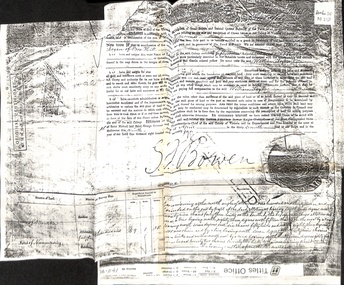
Certificate - Land Title, Willliam Logan, 9/04/1874
Photocopy of original certificate granting William Logan allotment no 144, Parish of Nunawading.logan, william, bowen, george ferguson (sir), land settlement -
Whitehorse Historical Society Inc.
Legal record - Land Title, Lemon Grove Nunawading, 1953
Certificate of Title: vol. 7827 fol. 071 to Tom SavageCertificate of Title: vol. 7827 fol. 071 to Tom Savage with transfers from October 1954 to 1970, recording subdivisionsCertificate of Title: vol. 7827 fol. 071 to Tom Savagesavage, tom, savage, grace beatrice, holmes, barbara ann, springfield road, nunawading, efron street, nunawading, savage court, nunawading, lemon grove, nunawading -
 Whitehorse Historical Society Inc.
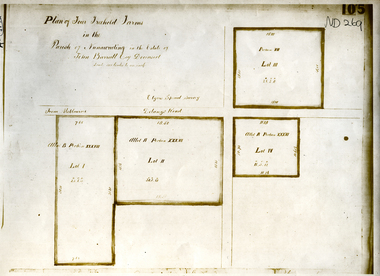
Document, Parish of Nunawading
Plan of four farms in the estate of John BarrattPlan of four farms in the estate of John Barratt on Delaneys RoadPlan of four farms in the estate of John Barratt parish of nunawading, barratt, john, delaney's road, ringwood north, elgars special survey, land subdivision -
Whitehorse Historical Society Inc.
Map, Gill's Springfield Road Estate, 1950?
Plan of subdivision for Gill's Springfield Road Estate, former orchard, 16 lots.Plan of subdivision for Gill's Springfield Road Estate, former orchard, 16 lots. Reprinted by Real Estate Agent, Spencer Jackson.Plan of subdivision for Gill's Springfield Road Estate, former orchard, 16 lots. land subdivision, norway avenue, blackburn, springfield road, blackburn, beverley crescent, blackburn, kevin avenue, blackburn, kerr street, blackburn, bordeaux avenue, blackburn, gill's estate, orchards, spencer jackson -
 Whitehorse Historical Society Inc.
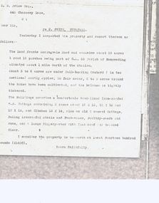
Document, Statutory Declaration, 1/6/1888
Statutory Declaration dated 1/6/1888 by Owen Alfred Kefford of Spencer Street, Melbournekefford, owen alfred, richard, land subdivision, canterbury road, forest hill, fisher, james, coley, morgan, collier, robert, cuttle, thomas nathaniel, forest hill heights pty. ltd. -
Whitehorse Historical Society Inc.
Document, Register of Sales, 1910 - 1911
Pages 1 - 73 of Register of Sales in and around Melbourne, 1910 - 1911Pages 1 - 73 of Register of Sales in and around Melbourne, 1910 - 1911 of T.R.B. Morton & Coghill, Auctioneers, p. 13 - 22 record Blackburn sales.Pages 1 - 73 of Register of Sales in and around Melbourne, 1910 - 1911 t.r.b. morton & coghill, land sales, blackburn -
Whitehorse Historical Society Inc.
Document, Nunawading land boomers
Outline for a musical play 'Nunawading'.Outline for a musical play 'Nunawading'. General theme - development of Nunawading from 1854 - 1894 - dialogue and music included. Music - Bruce Adams, Dialogue - Keith Patterson.Outline for a musical play 'Nunawading'. plays, adams, keith, patterson, keith arthur -
 Whitehorse Historical Society Inc.
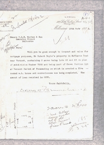
Document, McClares Road Vermont, 16/10/1922 12:00:00 AM
Photocopy of valuation of Robert Boyle's propertyPhotocopy of valuation of Robert Boyle's property in McClare's Road Vermont in 1922.Photocopy of valuation of Robert Boyle's property land values, boyle, robert, mcclares road, vermont, farmer and turner (solicitors) -
 Whitehorse Historical Society Inc.
Document, Blight's property
Valuation of Blight's propertyValuation of Blight's property on the corner of Springvale and Canterbury Roads, Forest Hill.Valuation of Blight's property land values, blight, canterbury road, forest hill, springvale road, gray, a.c. -
 Whitehorse Historical Society Inc.
Document, T. White's property, ca 1933
Valuation of T. White's property,Valuation of T. White's property, an orchard on Springvale Road, Tunstall. Attached is a handwritten letter giving a lower value.Valuation of T. White's property, land values, white, t., tunstall, springvale road, nunawading, price, charles s. -
 Whitehorse Historical Society Inc.
Pamphlet, Scoresby EES, 1/07/1998 12:00:00 AM
Information bulletin on the Scoresby Transport CorridorInformation bulletin on the Scoresby Transport Corridor on exhibition for public comment. It covers major possible transport projects in the area between Ringwood and Frankston including freeways, extensions to the Burwood tram line and the Glen Waverley Rail line.Information bulletin on the Scoresby Transport Corridorfreeways, scoresby transport corridor environment effects statement, ringwood, south eastern freeway, frankston, burwood highway, dandenong, victoria, libraries, transport, land use, springvale road burwood, burwood, tram services -
Whitehorse Historical Society Inc.
Book, Favourite escapes to the outer east, 1/03/2002 12:00:00 AM
100 years of holidays, picnics, excursions and sporting carnivals held in the outer eastern region of Melbourne.100 years of holidays, picnics, excursions and sporting carnivals held in the outer eastern region of Melbourne. Compiled from articles submitted by local historical societies100 years of holidays, picnics, excursions and sporting carnivals held in the outer eastern region of Melbourne. picnics, land sales, blackburn lake, scout groups, eastern suburbs, melbourne, camping, holidays, excursions, open air school no 3850 blackburn -
Whitehorse Historical Society Inc.
Document, McGlone's Estate Mitcham, 1/04/1921 12:00:00 AM
Copy of pamphlet of McGlone's Estate, Mitcham auctioned April 1921.Copy of pamphlet of McGlone's Estate, Mitcham auctioned April 1921. 24 allotments. Bordered by Whitehorse Road, McGlone Street, Station Street and Mitcham railway line and station. Original in Haughton maps, LaTrobe Library.Copy of pamphlet of McGlone's Estate, Mitcham auctioned April 1921. land sales, auctions, mcglone, john, mcglone, elizabeth, whitehorse road, mitcham, mcglone street, mitcham, station street, mitcham, mitcham railway station, haughton map collection, state library of victoria. latrobe library -
Whitehorse Historical Society Inc.
Legal record - Land Title, Deep Creek Road, Mitcham, 1936
Certificate of Title vol 6087 Fol 1217316 Lot 133 of plan of subdivision no 8022 in the name of Francisco Schwerkolt on 22 Dec 1936 including transactions until Oct 2000.Certificate of Title vol 6087 Fol 1217316 Lot 133 of plan of subdivision no 8022 in the name of Francisco Schwerkolt on 22 Dec 1936 including transactions until Oct 2000.Certificate of Title vol 6087 Fol 1217316 Lot 133 of plan of subdivision no 8022 in the name of Francisco Schwerkolt on 22 Dec 1936 including transactions until Oct 2000.schwerkolt, francisco, deep creek road, mitcham, no 27., rangeview grove, hogan, frances dora, collins, douglas alexander, oulton alice, vicic, susan manuella, hammond, wayne, alexander, hannelore -
Whitehorse Historical Society Inc.
Legal record - Land Title, Certificate of Title, 1974 - 1998
Certificate of Title: Vol 09048, Fol 467 Lot 1, Plan of Subdivision 113045, 64 Quarry Street, MitchamCertificate of Title: Vol 09048, Fol 467 Lot 1, Plan of Subdivision 113045, 64 Quarry Street, MitchamCertificate of Title: Vol 09048, Fol 467 Lot 1, Plan of Subdivision 113045, 64 Quarry Street, Mitchamquarry road, mitcham, no 64, land titles, mcclare, john, the glade, robertson, susan jayne, peter-budge -
Whitehorse Historical Society Inc.
Legal record - Land Title, Certificate of Title, 1964 - 1999
Certificate of Title: Lot 2 Subdivision No 63627, Bruce Street, MitchamCertificate of Title: Lot 2 Subdivision No 63627, Bruce Street, MitchamCertificate of Title: Lot 2 Subdivision No 63627, Bruce Street, Mitchambruce street, mitcham, land titles, mclennan, doris, peter, dunlavin road -
Whitehorse Historical Society Inc.
Legal record - Land Title, Certificate of Title, 1925 - 1990
Certificate of Title. 36 Burnett Street, Mitcham. Vol 4991 Fol 998076 being Lot 21 of Subdivision No 6626.Certificate of Title. 36 Burnett Street, Mitcham. Vol 4991 Fol 998076 being Lot 21 of Subdivision No 6626.Certificate of Title. 36 Burnett Street, Mitcham. Vol 4991 Fol 998076 being Lot 21 of Subdivision No 6626.burnett street, mitcham, no 36, land titles, thomas street, green, david hamilton -
 Whitehorse Historical Society Inc.
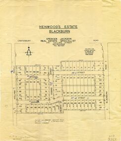
Map, Henwoods Estate, Blackburn
Plan of subdivision in Blackburn SouthPlan of subdivision in Blackburn South between Holland Road and Blackburn Road. Estate advertised by Spencer Jackson, 341 Collins Street.Plan of subdivision in Blackburn South land subdivision, henwoods estate, blackburn south, holland road, brazeel street, marama street, blackburn road, gissing street, hearty street -
Whitehorse Historical Society Inc.
Map, Burwood Road, Box Hill City, 15/02/1952 12:00:00 AM
Plan of subdivision of ten blocks in Burwood Road, Burwood.Plan of subdivision of ten blocks in Burwood Road, Burwood between Milford Avenue and Station Street. Marked as Survey Plan No 5441.Plan of subdivision of ten blocks in Burwood Road, Burwood. land subdivision, burwood road, burwood, milford avenue, burwood, central court, burwood