Showing 32434 items
matching c-farrell
-
 Geoffrey Kaye Museum of Anaesthetic History
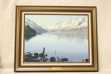
Painting, Graham Binsley, Lake Ohau, New Zealand
An oil painting on board depicting a scene of snow-capped mountains around Lake Ohau, New Zealand. The painting is set in a fabric mount with a gold and bronze frame. There is a brass plaque affixed to the front of the frame detailing donor information.Plaque on front of frame. "LAKE OHAU, NEW ZEALAND / Presented By C. McK HOLMES / June, 1990"lake ohau, painting, oil paint, oil painting, scenery, landscape, landscape painting -
 Moorabbin Air Museum
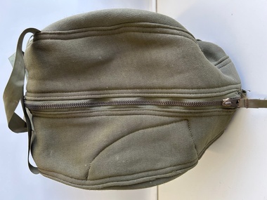
Equipment (item) - US Military Pilot Carry Case For Helmet And Oxygen Mask
Specification MIL-C-19666A(WEP) Contract No. DSA-100-1203 Sock No. 8415-753-2901 -
 Creswick Campus Historical Collection - University of Melbourne
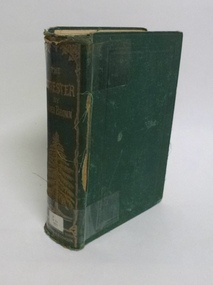
Book - The Forester, James Brown, The Forester or a Practical Treatise on the Planting, Rearing, and General Managament of Forest-Trees, 1871
-
 Wangaratta RSL Sub Branch
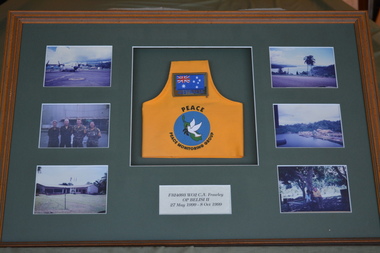
Mixed media - Framed Photos, Op Belisi II
April 30 1998, marked the transition from the New Zealand led Truce Monitoring Group (TMG), OP BEL ISI (I), to the Australian led Peace Monitoring Group (PMG) and the beginning of OP BEL ISI (II). The transition occurred following the signing of the Ceasefire Agreement in the Arawa township on Bougainville Island earlier that day. The PMG consisted of about 100 people from Australia, NZ, Fiji and Vanuatu. F324093 WO2 Cheryl A Frawley was a member of OP BEL ISI II serving between 27 May and 8 0ctober 1999 Brown timber frame with green mount containing six photographs and yellow brassardF324093 WO2 C A Frawley OP Belisi II 27 May 1999 - 8 0ct 1999op belisi ii, wo2 frawley -
 Bendigo Military Museum
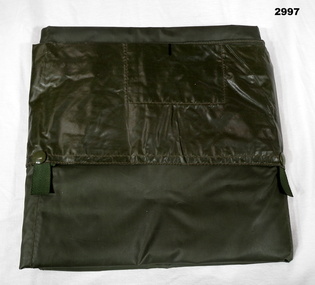
Equipment - MATTRESS COVER, 1969
Item issued to Peter BALL 3796117. Refer Cat No 4704Woven, waterproof, green cover divided into 3 sections to hold individual blow up mattresses. Fitted with press studs to secure each mattress. The cover was also just used as a ground sheet minus the blow ups.“Conlons Australia 1969 [up arrow] 7210 / 66 / 011 / 5818” Handwritten “P C BALL”military, bedding, cover -
 The Beechworth Burke Museum
Photograph, c. 1905
Taken in c. 1905, depicted is a large group of children and adults dressed in formal attire sitting and standing upon a granite rock that is located in the centre of Queen Victoria Park. In front of the group is a wooden picket wire fence that sides the granite rock. On top of the rock is a gas lamp post.Originally known as the Beechworth Botanical Gardens, the Queen Victoria Park features a extensive collection of historic trees and plants, which have been listed on the Indigo Shire’s Significant Tree Register.Black and white rectangular reproduced photograph printed on matte photographic paperReverse: 6956 (in pencil)/ ©/ DONALD HAYES/ BEECHWORTH (stamped in orange ink)/entertainment album, burke museum, beechworth, queen victoria park, park -
 Tatura Irrigation & Wartime Camps Museum
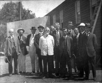
Photograph, Tatura Fruit Cannery group, c.1920
Original photo in possession of Thomas Flanagan. Tatura Fruit Cannery group c.1924, Thomas Martin (Shire Secretary) far left; J.J. Hanlon; J.A.Carey; L.Whitney; W.Hunter; H.S.Davy; W.Wilson; E.J. Quini; D.C.Morrison; J.S.Hill;T.D.Edwards; W.A. Cullinan. Possibly the opening ceremony, 1919.Professional black & white photograph mounted of a group of men in suits.On back- list of names.tatura cannery -
 Uniting Church Archives - Synod of Victoria
Photograph, undated, c. 1890
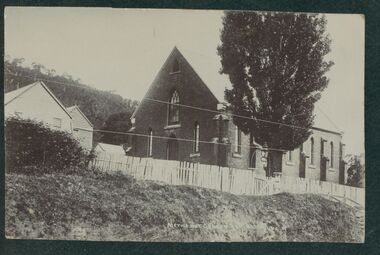
The Wandiligong Methodist Church was opened on Easter Sunday 1878. It was built next to the original timber church (c.1850s) which continued to be used as a hall and vestry. Contractors were Mr T. Kaighin Snr, and Messrs. Parkhill and Gillard. Mr T. Kaighin Snr also acted as architect.B & W exterior view of the Wandiligong Methodist Church and Hall. Postcard format.wandiligong, wesleyan methodist, , t. kaighin snr, parkhill, gillard -
 Bialik College
Photograph (item) - Students celebrating Succot at Shakespeare Grove, c. 1963-1964, c. 1963-1964
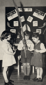
Students celebrating Succot at Shakespeare Grove, c. 1963-1964. Girl on left appears to be holding an etrog, and the boy in the centre appears to be holding a lulav. The girl on the right appears to be holding a prayer book (Siddur) and may be reciting a prayer. Please contact [email protected] to request access to this record.1960s, judaism -
 Kew Historical Society Inc
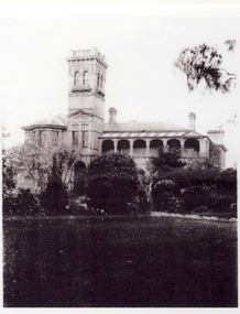
Photograph - 'Illapa', Princess Street, c.1920
The Hedderwick family lived in a number of houses in Kew, including 'Illapa' and 'Garoopna'. Illapa, pictured here, was built for Henry Hedderwick in c.1890. The house was to become 'St Joseph's Tower' and more recently 'Rylands' Kew This photograph is part of a larger donation of items relating to the Hedderwick family of Kew.Monochrome, Black and white print copy of 'Illapa' in Princess Street, built for Henry Hedderwick, lawyer and local politician.henry hedderwick, illapa -- princes street -
 Lakes Entrance Historical Society
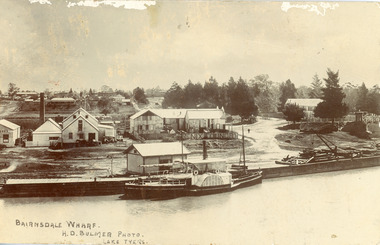
Postcard - P.S. Tanjil, Bulmer H D, 1910 c
Postcard was addressed to Mr. H Lindamen, C/o JCD, Bairnsdale. Postcard bears a One Penny red Queen Victoria stamp, franked with number 17. Message on card scribbled out, another stamp has been removed. Also enlargement 16 x 25 cmBlack and white postcard showing P S Tanjil at Bairnsdale Wharf, Victoria. Shed and timber and hand crane on wharf. Industrial buildings, eg, butter factory, foundry behind wharf, post and rail fences, gravel roads and tannery on right, pine trees and end of bridge on far right. Bairnsdale township in background.Bairnsdale Wharf. H.D Bulmer Photo Lake Tyersships and shipping, waterways, wharfs -
 Bialik College
Textile - Bialik College Banner, c. 1960s, c. 1960s
School banner made c. 1960s out of blue felt material. Features decorative boarder, hanging tassels at the bottom and Bialik College logo in yellow and white paint. It was often used at events and features in photographs of school events. Please contact [email protected] to request access to this record.object -
 Charlton Golden Grains Museum Inc
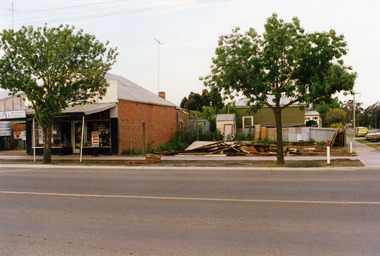
Photograph, Charlton Shire, c.1987
Corner High Street and Learmonth Street. 2 shops demolished by Greg Fatheres. Shop on left Paterson's fruit and veg c.1935. Butchers shop. rebuilt by Graeme Turner, Marini's take away cafe. Dalgety's, Building at back home of Sheisa Volch facing Learnmouth Street.Corner High Street and Learmonth Street, 2 Shops demolished by Greg Fathersdemolition, charlton, high street, shops, butcher, business, dalgety's, paterson -
 Kew Historical Society Inc
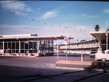
Photograph - California Motel, Barkers Road, Ron Setford, 1961
Ron Setford and his wife Grace Setford lived in Tanner Avenue, East Kew, from c.1946 to c.1995. A keen photographer, he recorded the changing face of Kew over a 20 year period. Apart from 30 photographs of built structures and places in Kew dating from 1960 and 1961, 145 of his 35mm colour slides chronicle the development of the Eastern Freeway through the Yarra Valley over a five year period from c.1972 to c.1977. This important collection was donated to the Society by his granddaughter in 2025.This collection of 175 35mm slides is of local and statewide significance, owing to its subject matter, particularly the major development of road transport infrastructure during the 1970s with the construction of the Eastern Freeway. The photographer also took care to annotate and date most of his slides which enable the researcher to pinpoint temporal and spatial locations.Opened in 1960, the California Motel at 138 Barkers Road, Hawthorn, was located opposite the entrance to Xavier College and built on the site of the former Barker railway station of the closed Kew branch line. The motel was advertised as “away from the hustle and bustle of the city and offering affordable accommodation for the business or leisure traveller”. Special amenities included air-conditioning, a business centre, and swimming pool. The motel had 82 suites. A possibly forgotten, but perhaps essential feature of the motel, was the Caltex Service Station at its entrance. The building was closed in April 2008, extensively vandalised and finally demolished in 2013."California Motel"ron setford, photographs -- kew (vic.) -- 1960s, california motel -- barkers road -- hawthorn (vic.) -
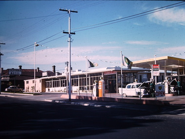 Kew Historical Society Inc
Photograph - California Motel, Barkers Road, Kew, Ron Setford, 1961
Ron Setford and his wife Grace Setford lived in Tanner Avenue, East Kew, from c.1946 to c.1995. A keen photographer, he recorded the changing face of Kew over a 20 year period. Apart from 30 photographs of built structures and places in Kew dating from 1960 and 1961, 145 of his 35mm colour slides chronicle the development of the Eastern Freeway through the Yarra Valley over a five year period from c.1972 to c.1977. This important collection was donated to the Society by his granddaughter in 2025.This collection of 175 35mm slides is of local and statewide significance, owing to its subject matter, particularly the major development of road transport infrastructure during the 1970s with the construction of the Eastern Freeway. The photographer also took care to annotate and date most of his slides which enable the researcher to pinpoint temporal and spatial locations.Opened in 1960, the California Motel at 138 Barkers Road, Hawthorn, was located opposite the entrance to Xavier College and built on the site of the former Barker railway station of the closed Kew branch line. The motel was advertised as “away from the hustle and bustle of the city and offering affordable accommodation for the business or leisure traveller”. Special amenities included air-conditioning, a business centre, and swimming pool. The motel had 82 suites. A possibly forgotten, but perhaps essential feature of the motel, was the Caltex Service Station at its entrance. The building was closed in April 2008, extensively vandalised and finally demolished in 2013.Nilron setford, photographs -- kew (vic.) -- 1960s, california hotel -- barkers road -- hawthorn (vic.), california motel -- barkers road -
 Kew Historical Society Inc
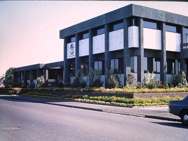
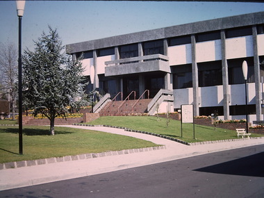
Photograph - Kew Civic Offices, Ron Setford, 1973
Ron Setford and his wife Grace Setford lived in Tanner Avenue, East Kew, from c.1946 to c.1995. A keen photographer, he recorded the changing face of Kew over a 20 year period. Apart from 30 photographs of built structures and places in Kew dating from 1960 and 1961, 145 of his 35mm colour slides chronicle the development of the Eastern Freeway through the Yarra Valley over a five year period from c.1972 to c.1977. This important collection was donated to the Society by his granddaughter in 2025.This collection of 175 35mm slides is of local and statewide significance, owing to its subject matter, particularly the major development of road transport infrastructure during the 1970s with the construction of the Eastern Freeway. The photographer also took care to annotate and date most of his slides which enable the researcher to pinpoint temporal and spatial locations."Kew - "Taj-Mahal" / Cotham Rd - Charles St / Oct 73"ron setford, kew civic offices -
 Kew Historical Society Inc
Photograph - Kew Civic Offices, Ron Setford, 1973
Ron Setford and his wife Grace Setford lived in Tanner Avenue, East Kew, from c.1946 to c.1995. A keen photographer, he recorded the changing face of Kew over a 20 year period. Apart from 30 photographs of built structures and places in Kew dating from 1960 and 1961, 145 of his 35mm colour slides chronicle the development of the Eastern Freeway through the Yarra Valley over a five year period from c.1972 to c.1977. This important collection was donated to the Society by his granddaughter in 2025.This collection of 175 35mm slides is of local and statewide significance, owing to its subject matter, particularly the major development of road transport infrastructure during the 1970s with the construction of the Eastern Freeway. The photographer also took care to annotate and date most of his slides which enable the researcher to pinpoint temporal and spatial locations."Kew Taj-Mahal"ron setford, kew civic offices -
 Kew Historical Society Inc
Photograph - Kew Civic Offices, Ron Setford, 1973
Ron Setford and his wife Grace Setford lived in Tanner Avenue, East Kew, from c.1946 to c.1995. A keen photographer, he recorded the changing face of Kew over a 20 year period. Apart from 30 photographs of built structures and places in Kew dating from 1960 and 1961, 145 of his 35mm colour slides chronicle the development of the Eastern Freeway through the Yarra Valley over a five year period from c.1972 to c.1977. This important collection was donated to the Society by his granddaughter in 2025.This collection of 175 35mm slides is of local and statewide significance, owing to its subject matter, particularly the major development of road transport infrastructure during the 1970s with the construction of the Eastern Freeway. The photographer also took care to annotate and date most of his slides which enable the researcher to pinpoint temporal and spatial locations."Kew Council Offices"ron setford, kew civic offices -
 Kew Historical Society Inc
Photograph - Kew Civic Offices, Ron Setford, 1973
Ron Setford and his wife Grace Setford lived in Tanner Avenue, East Kew, from c.1946 to c.1995. A keen photographer, he recorded the changing face of Kew over a 20 year period. Apart from 30 photographs of built structures and places in Kew dating from 1960 and 1961, 145 of his 35mm colour slides chronicle the development of the Eastern Freeway through the Yarra Valley over a five year period from c.1972 to c.1977. This important collection was donated to the Society by his granddaughter in 2025.This collection of 175 35mm slides is of local and statewide significance, owing to its subject matter, particularly the major development of road transport infrastructure during the 1970s with the construction of the Eastern Freeway. The photographer also took care to annotate and date most of his slides which enable the researcher to pinpoint temporal and spatial locations."The "Taj-Mahal" / $1.250.000 Council Offices (we have to pay for it)"ron setford, photographs -- kew (vic.) -- 1960s, kew civic offices, kew town hall -
 Kew Historical Society Inc
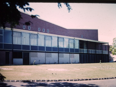
Photograph - Kew Civic Hall and World War II War Memorial, Ron Setford, 1960
Ron Setford and his wife Grace Setford lived in Tanner Avenue, East Kew, from c.1946 to c.1995. A keen photographer, he recorded the changing face of Kew over a 20 year period. Apart from 30 photographs of built structures and places in Kew dating from 1960 and 1961, 145 of his 35mm colour slides chronicle the development of the Eastern Freeway through the Yarra Valley over a five year period from c.1972 to c.1977. This important collection was donated to the Society by his granddaughter in 2025.This collection of 175 35mm slides is of local and statewide significance, owing to its subject matter, particularly the major development of road transport infrastructure during the 1970s with the construction of the Eastern Freeway. The photographer also took care to annotate and date most of his slides which enable the researcher to pinpoint temporal and spatial locations."Kew Town Hall"ron setford, photographs -- kew (vic.) -- 1960s, kew town hall -
 Kew Historical Society Inc
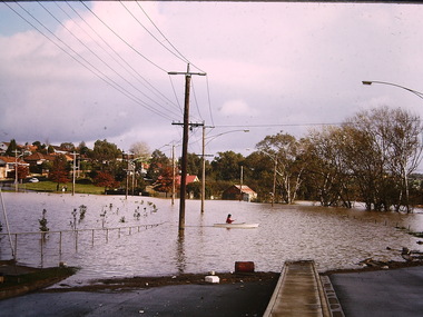
Photograph - Flooding, Kilby Road, Kew, Ron Setford, 1974
Ron Setford and his wife Grace Setford lived in Tanner Avenue, East Kew, from c.1946 to c.1995. A keen photographer, he recorded the changing face of Kew over a 20 year period. Apart from 30 photographs of built structures and places in Kew dating from 1960 and 1961, 145 of his 35mm colour slides chronicle the development of the Eastern Freeway through the Yarra Valley over a five year period from c.1972 to c.1977. This important collection was donated to the Society by his granddaughter in 2025.This collection of 175 35mm slides is of local and statewide significance, owing to its subject matter, particularly the major development of road transport infrastructure during the 1970s with the construction of the Eastern Freeway. The photographer also took care to annotate and date most of his slides which enable the researcher to pinpoint temporal and spatial locations."Flood Kilby Road / May 74"ron setford, floods -- kew (vic.), kilby road -- kew (vic.) -
 Kew Historical Society Inc
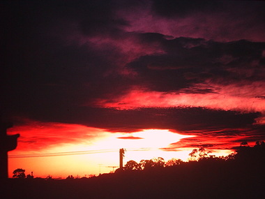
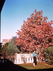
Photograph - Sunrise over Kew East, Ron Setford, 1969
Ron Setford and his wife Grace Setford lived in Tanner Avenue, East Kew, from c.1946 to c.1995. A keen photographer, he recorded the changing face of Kew over a 20 year period. Apart from 30 photographs of built structures and places in Kew dating from 1960 and 1961, 145 of his 35mm colour slides chronicle the development of the Eastern Freeway through the Yarra Valley over a five year period from c.1972 to c.1977. This important collection was donated to the Society by his granddaughter in 2025.This collection of 175 35mm slides is of local and statewide significance, owing to its subject matter, particularly the major development of road transport infrastructure during the 1970s with the construction of the Eastern Freeway. The photographer also took care to annotate and date most of his slides which enable the researcher to pinpoint temporal and spatial locations."Sunrise over East Kew [Aug69}"ron setford, photographs -- kew (vic.) -- 1960s, kew east -
 Kew Historical Society Inc
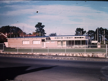
Photograph - Kew Bowling Club -- Wellington Street (Kew), Ron Setford
Ron Setford and his wife Grace Setford lived in Tanner Avenue, East Kew, from c.1946 to c.1995. A keen photographer, he recorded the changing face of Kew over a 20 year period. Apart from 30 photographs of built structures and places in Kew dating from 1960 and 1961, 145 of his 35mm colour slides chronicle the development of the Eastern Freeway through the Yarra Valley over a five year period from c.1972 to c.1977. This important collection was donated to the Society by his granddaughter in 2025.This collection of 175 35mm slides is of local and statewide significance, owing to its subject matter, particularly the major development of road transport infrastructure during the 1970s with the construction of the Eastern Freeway. The photographer also took care to annotate and date most of his slides which enable the researcher to pinpoint temporal and spatial locations.Nilron setford, kew bowling club, wellington street -- kew (vic.), sport and recreation -- kew (vic.) -
 Kew Historical Society Inc
Photograph - Liquid Amber, Ron Setford
Ron Setford and his wife Grace Setford lived in Tanner Avenue, East Kew, from c.1946 to c.1995. A keen photographer, he recorded the changing face of Kew over a 20 year period. Apart from 30 photographs of built structures and places in Kew dating from 1960 and 1961, 145 of his 35mm colour slides chronicle the development of the Eastern Freeway through the Yarra Valley over a five year period from c.1972 to c.1977. This important collection was donated to the Society by his granddaughter in 2025.This collection of 175 35mm slides is of local and statewide significance, owing to its subject matter, particularly the major development of road transport infrastructure during the 1970s with the construction of the Eastern Freeway. The photographer also took care to annotate and date most of his slides which enable the researcher to pinpoint temporal and spatial locations.Nilron setford, gardens. - kew (vic.) -
 Kew Historical Society Inc
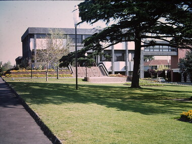
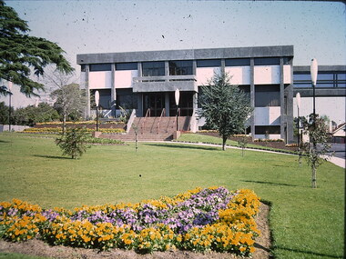
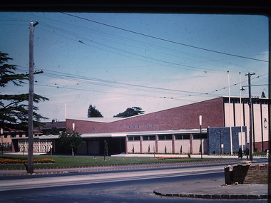
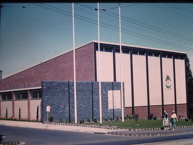
Photograph - Kew City Hall, Ron Setford, 1960
Ron Setford and his wife Grace Setford lived in Tanner Avenue, East Kew, from c.1946 to c.1995. A keen photographer, he recorded the changing face of Kew over a 20 year period. Apart from 30 photographs of built structures and places in Kew dating from 1960 and 1961, 145 of his 35mm colour slides chronicle the development of the Eastern Freeway through the Yarra Valley over a five year period from c.1972 to c.1977. This important collection was donated to the Society by his granddaughter in 2025.This collection of 175 35mm slides is of local and statewide significance, owing to its subject matter, particularly the major development of road transport infrastructure during the 1970s with the construction of the Eastern Freeway. The photographer also took care to annotate and date most of his slides which enable the researcher to pinpoint temporal and spatial locations.The Kew City Hall in Cotham Road, designed by Harold Bartlett, was intended as the initial phase in a scheme to develop an entire civic precinct. This was representative of a widely-held belief, of the immediate post-war era, that a district's civic centre should be precisely that – not just a single grand building for official use, but a dedicated precinct providing a range of community facilities as well as an administrative function. The Kew masterplan was later abandoned. The City Hall was designed to cater for public or official functions. Its interior had a small stage at one end for intimate theatrical productions, a larger stage at the other (with sunken orchestra pit) for musical performances, plus the most up-to-date equipment for live TV transmission."Kew Town Hall"ron setford, photographs -- kew (vic.) -- 1960s, kew town hall -
 Kew Historical Society Inc
Photograph - Country Roads Board and Denmark Street Baby Health Centre, Ron Setford, 1961
Ron Setford and his wife Grace Setford lived in Tanner Avenue, East Kew, from c.1946 to c.1995. A keen photographer, he recorded the changing face of Kew over a 20 year period. Apart from 30 photographs of built structures and places in Kew dating from 1960 and 1961, 145 of his 35mm colour slides chronicle the development of the Eastern Freeway through the Yarra Valley over a five year period from c.1972 to c.1977. This important collection was donated to the Society by his granddaughter in 2025.This collection of 175 35mm slides is of local and statewide significance, owing to its subject matter, particularly the major development of road transport infrastructure during the 1970s with the construction of the Eastern Freeway. The photographer also took care to annotate and date most of his slides which enable the researcher to pinpoint temporal and spatial locations.A photograph providing a visual contrast of the pre and post-World War II architectural styles of the Denmark Street Baby Health Centre and two of the Country Roads Board office buildings. Each was built on part of the land fronting the Kew branch line. In May 1939, the Railway Commissioners agreed to lease a site at the Kew Railway Station for a Baby Health Centre. The single-storey cream brick building was designed by Roland Chipperfield. The Country Roads Board (1913–83), later renamed VicRoads, transferred its headquarters from the Royal Exhibition Building to Kew in 1961, following the completion of two modernist eight-storey office towers in 1960. The VicRoads buildings were closed in 2024, and there is ongoing debate about what replaces them.Nilron setford, photographs -- kew (vic.) -- 1960s, country roads board, vicroads, denmark street -- kew (vic.), denmark street baby health centre -
 Kew Historical Society Inc
Photograph - Kew City Hall, Ron Setford, 1960
Ron Setford and his wife Grace Setford lived in Tanner Avenue, East Kew, from c.1946 to c.1995. A keen photographer, he recorded the changing face of Kew over a 20 year period. Apart from 30 photographs of built structures and places in Kew dating from 1960 and 1961, 145 of his 35mm colour slides chronicle the development of the Eastern Freeway through the Yarra Valley over a five year period from c.1972 to c.1977. This important collection was donated to the Society by his granddaughter in 2025.This collection of 175 35mm slides is of local and statewide significance, owing to its subject matter, particularly the major development of road transport infrastructure during the 1970s with the construction of the Eastern Freeway. The photographer also took care to annotate and date most of his slides which enable the researcher to pinpoint temporal and spatial locations.The Kew City Hall in Cotham Road, designed by Harold Bartlett, was intended as the initial phase in a scheme to develop an entire civic precinct. This was representative of a widely-held belief, of the immediate post-war era, that a district's civic centre should be precisely that – not just a single grand building for official use, but a dedicated precinct providing a range of community facilities as well as an administrative function. The Kew masterplan was later abandoned. The City Hall was designed to cater for public or official functions. Its interior had a small stage at one end for intimate theatrical productions, a larger stage at the other (with sunken orchestra pit) for musical performances, plus the most up-to-date equipment for live TV transmission.Nilron setford, photographs -- kew (vic.) -- 1960s, kew town hall -
 Kew Historical Society Inc
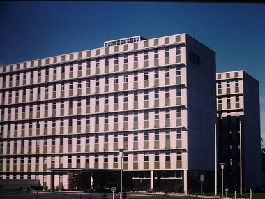
Photograph - Country Roads Board, Ron Setford, 1961
Ron Setford and his wife Grace Setford lived in Tanner Avenue, East Kew, from c.1946 to c.1995. A keen photographer, he recorded the changing face of Kew over a 20 year period. Apart from 30 photographs of built structures and places in Kew dating from 1960 and 1961, 145 of his 35mm colour slides chronicle the development of the Eastern Freeway through the Yarra Valley over a five year period from c.1972 to c.1977. This important collection was donated to the Society by his granddaughter in 2025.This collection of 175 35mm slides is of local and statewide significance, owing to its subject matter, particularly the major development of road transport infrastructure during the 1970s with the construction of the Eastern Freeway. The photographer also took care to annotate and date most of his slides which enable the researcher to pinpoint temporal and spatial locations.Nilron setford, photographs -- kew (vic.) -- 1960s, country roads board, vicroads, denmark street -- kew (vic.) -
 Kew Historical Society Inc
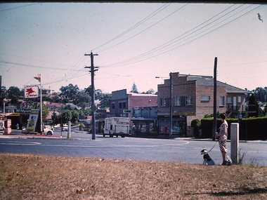
Photograph - North Kew Village, Ron Setford, 1960
Ron Setford and his wife Grace Setford lived in Tanner Avenue, East Kew, from c.1946 to c.1995. A keen photographer, he recorded the changing face of Kew over a 20 year period. Apart from 30 photographs of built structures and places in Kew dating from 1960 and 1961, 145 of his 35mm colour slides chronicle the development of the Eastern Freeway through the Yarra Valley over a five year period from c.1972 to c.1977. This important collection was donated to the Society by his granddaughter in 2025.This collection of 175 35mm slides is of local and statewide significance, owing to its subject matter, particularly the major development of road transport infrastructure during the 1970s with the construction of the Eastern Freeway. The photographer also took care to annotate and date most of his slides which enable the researcher to pinpoint temporal and spatial locations."Nth Kew Village"ron setford, photographs -- kew (vic.) -- 1960s, north kew village, willsmere village