Showing 1549 items matching " aerial photographs"
-
 Glenelg Shire Council Cultural Collection
Photograph - Photograph - Cape Grant Quarry, n.d
Port of Portland Authority ArchivesBack: 'JAN 24, 1968' - pencil, top rightport of portland archives, cape grant quarry -
Glenelg Shire Council Cultural Collection
Photograph - Photograph - Cape Grant Quarry, 24/01/1968
Port of Portland Authority ArchivesBack: 'JAN 24, 1968 ' - pencil top rightport of portland archives, cape grant quarry -
Glenelg Shire Council Cultural Collection
Photograph - Photograph - Cape Grant Quarry, n.d
Port of Portland Authority ArchivesBack: 1 cm border ruled around photo in pencil. 'Reduce to 28 ems wide' in pencil, top border. '(15); pencil, bottom border. '58 %' - green pencil, centreport of portland archives, cape grant quarry -
Glenelg Shire Council Cultural Collection
Photograph - Aerial Survey Railway Record Print – 1952, 03/05/1952
... strip on image. Photograph Aerial Survey Railway Record Print ...Victorian Railways aerial survey record print of the railway line between Heywood and Rennick (S.A. border) Black and white, white vertical strip on image.Back: 'Heywood - Rennick 21080 - 19371 235m 75c Heywood' - all black ink. Purple VR aerial survey stamp. '3 May 1952' - black stamp -
Glenelg Shire Council Cultural Collection
Photograph - Aerial Survey Railway Record Print - 1952, 03/05/1952
... strip on image. Photograph Aerial Survey Railway Record Print ...These photos were found in a car that was left for recycling.Victorian Railways aerial survey record print of the railway line between Heywood and Rennick (S.A. border) Black and white, white vertical strip on image.Front: 'to Rennick, Heywood from Melbourne' in the white strip Back: 'Heywood - Rennick 21069 - 19360. 235m31c Heywood' - all black ink. Purple VR aerial survey stamp. '3 May 1952' - black stamp -
Glenelg Shire Council Cultural Collection
Photograph - Aerial Survey Railway Record Print – 1952, 03/05/1952
... strip on image. Photograph Aerial Survey Railway Record Print ...Victorian Railways aerial survey record print of the railway line between Heywood and Rennick (S.A. border) Black and white, white vertical strip on image.Back: 'Heywood - Rennick 21221 - 19502 248m 8c Heywood Lyons' - all black ink. Purple VR aerial survey stamp. '3 May 1952' - black stamp -
Glenelg Shire Council Cultural Collection
Photograph - Aerial Survey Railway Record Print - 1952, 03/05/1952
... vertical strip on image. Photograph Aerial Survey Railway Record ...These photos were found in a car that was left for recycling.Victorian Railways aerial survey record print of the railway line between Heywood and Rennick (S.A. border) Black and white, white vertical strip on image.Back: 'Heywood - Rennick 21293 - 19565 254m 10c Greenwald'- all black ink. Purple VR aerial survey stamp. '3 May 1952' - black stampvictorian railways -
Glenelg Shire Council Cultural Collection
Photograph - Photograph - aerial view of railway line, 03/05/1952
... Photograph - aerial view of railway line... Cliff Street Portland great-ocean-road Victorian Railways aerial ...Victorian Railways aerial survey record print of the railway line between Heywood and Rennick (S.A. border) Black and white, white vertical strip on imageFront: Notations in black pen, added at a later date Back: 'Heywood - Rennick 21082 - 19373 235m 73c Heywood' - all black ink. Purple VR aerial survey stamp. '3 May 1952' - black stampvictorian railways, aerial photography, train line -
Glenelg Shire Council Cultural Collection
Photograph - Photograph - Aerial Photo railway line between Heywood and Rennick, 03/05/1952
... Photograph - Aerial Photo railway line between Heywood and... strip on image Photograph Photograph - Aerial Photo railway line ...Victorian Railways aerial survey record print of the railway line between Heywood and Rennick (S.A. border) Black and white, white vertical strip on imageFront: 'to Rennick, Heywood from Melbourn' in the whites strip Back: 'Heywood - Rennick 21077 - 19368 235m 67c Heywood' - all black ink. Purple VR aerial survey stamp. '3 May 1952' - black stamp -
Glenelg Shire Council Cultural Collection
Photograph - Aerial Survey Railway Record Print – 1952, 03/05/1952
... strip on image. Photograph Aerial Survey Railway Record Print ...Victorian Railways aerial survey record print of the railway line between Heywood and Rennick (S.A. border) Black and white, white vertical strip on image.Back: 'Heywood - Rennick 21071 - 19362 235m 39c Heywood' - all black ink. Purple VR aerial survey stamp. '3 May 1952' - black stamp -
Glenelg Shire Council Cultural Collection
Photograph - Aerial Survey Railway Record Print – 1952, 03/05/1952
... on image. Photograph Aerial Survey Railway Record Print – 1952 ...Victorian Railways aerial survey record print of the railway line between Heywood and Rennick (S.A. border) Black and white, white vertical strip on image.Front: Annotations in black ink added at a later date Back: 'Heywood - Rennick 21151 - 19432 241m 14c Heywood' - all black ink. Purple VR aerial survey stamp. '3 May 1952' - black stamp -
Glenelg Shire Council Cultural Collection
Photograph - Photograph - aerial view of Portland coastline, 1954
... Photograph - aerial view of Portland coastline...', at regular intervals Photograph Photograph - aerial view of Portland ...Black and white aerial photo of coastline around Portland. Black border, scale on all sides, 5 rows of 3 't', at regular intervalsFront: '607 -102' -- handwritten, white, lower border 'RUN 5' 'PORTLAND', printed, white, lower borderaerial photography, portland harbour, south west coastline -
Glenelg Shire Council Cultural Collection
Photograph, Aerial view of Port of Portland, n.d
Port of Portland Collectionport of portland -
Glenelg Shire Council Cultural Collection
Photograph, Softwoods Holdings Site, North Portland, April 1976, 1976
Port of Portland Authority archives.Back: Softwoods Holdings Site North Portland (lower left, pencil) APRIL, 1976 (lower left, blue pen) Portland Harbor Trust Commissioners (purple stamp, centre)port of portland -
Glenelg Shire Council Cultural Collection
Photograph, Arial view of CSR Softwoods, Dartmoor, n.d
Port of Portland Authority archives.Front: (no inscriptions) Back: (no inscriptions)port of portland -
 Glenelg Shire Council Cultural Collection
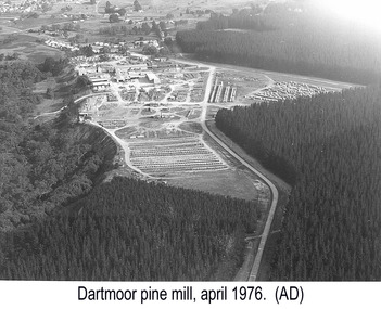
Photograph, Dartmoor Pine Mills, Apr-76
Port of Portland Authority archives.Front: (no inscriptions) Back: Portland Harbour Trust Commissioners (purple stamp) (centre). Dartmoor Pine Mills (lower left) (pencil) April, 1976 (lower left) (pen).port of portland -
![Photograph, Untitled [Aerial view of construction of CSR Softwood Dartmoor Mill], n.d](/media/collectors/4f729f5597f83e03086015b1/items/655a82f77f3f3810362ecfda/item-media/655a82fa7f3f3810362ef5bf/item-fit-380x285.jpg) Glenelg Shire Council Cultural Collection
Glenelg Shire Council Cultural CollectionPhotograph, Untitled [Aerial view of construction of CSR Softwood Dartmoor Mill], n.d
Port of Portland Authority archives.Front: (no inscriptions) Back: (no inscriptions)port of portland -
 Glenelg Shire Council Cultural Collection
Photograph, Southern Farmers & Australian Estates (Portland) Pty Ltd Wool Process, n.d
Port of Portland Authority archives.Front: (no inscriptions) Back: Portland Harbor Trust Commissioners (purple stamp, top left & bottom right)port of portland -
Glenelg Shire Council Cultural Collection
Photograph - Photograph - Portland foreshore construction, n.d
Port of Portland Authorityport of portland archives, aerial photography, portland harbour -
Glenelg Shire Council Cultural Collection
Photograph - Photograph - silos, n.d
Port of Portland Authority Archivesport of portland archives, port of portland, silos -
Glenelg Shire Council Cultural Collection
Photograph - Photograph - Thomas Borthwick & Sons, n.d
Port of Portland Authority ArchivesBack: Frame drawn in pencil. 94% in green pencil. Reduce to 53 cms wide. Full page in pencil. 6 -
Glenelg Shire Council Cultural Collection
Photograph - Photograph - Thomas Borthwick & Sons, n.d
Port of Portland Authority ArchivesBack: 40 7 3 in pencilport of portland archives, thomas borthwick and sons, abattoir -
Glenelg Shire Council Cultural Collection
Photograph - Photograph - aerial view of Portland Harbour, n.d
... Photograph - aerial view of Portland Harbour... of Bentinck St. & Cape Nelson Rd. Photograph Photograph - aerial view ...Port of Portland Authority Archivesport of portland archives, aerial photography, portland harbour -
Glenelg Shire Council Cultural Collection
Photograph - Photograph - aerial view of Portland, n.d
... Photograph - aerial view of Portland... of woodchips Photograph Photograph - aerial view of Portland ...Port of Portland AuthorityBack: harb003 - pencilport of portland archives, aerial photography, portland harbour -
Glenelg Shire Council Cultural Collection
Photograph - Photograph - aerial view of Portland harbour, n.d
... Photograph - aerial view of Portland harbour... construction. Photograph Photograph - aerial view of Portland harbour ...Port of Portland Authority ArchivesBack: Border ruled in pencil. 51 x 26 f5 - pencilport of portland archives, aerial photography, portland harbour -
Glenelg Shire Council Cultural Collection
Photograph, Photograph - Reclamation and Canal Work, 1959
Port of Portland Authority ArchivesBack: 1959 - black biroport of portland -
Glenelg Shire Council Cultural Collection
Photograph - Photograph - Portland Harbour, n.d
Port of Portland Authority Archivesport of portland archives, portland harbour -
Glenelg Shire Council Cultural Collection
Photograph - Photograph - Portland Harbour & Portland Town, 1958
Port of Portland Authority ArchivesBack: Purple stamp - 17 Nov 1958port of portland archives, portland harbour -
Glenelg Shire Council Cultural Collection
Photograph - Photograph - Portland Harbour, n.d
Port of Portland Authority Archivesport of portland archives, portland harbour -
Glenelg Shire Council Cultural Collection
Photograph - Photograph - Portland Harbour, n.d
Port of Portland Authority ArchivesBack: 2966 Blue Biro - 61/8 x 4/5 red pencil overwritten 3/4 in blue biroport of portland archives, portland harbour