Showing 1949 items matching " burwood"
-
 Whitehorse Historical Society Inc.
Article, Places For Kinder Kids In Jeopardy, 1993
State Government has proposed to merge kindergartens with child care centres.State Government has proposed to merge kindergartens with child care centres.State Government has proposed to merge kindergartens with child care centres.child care, fahey, vikki, benwerrin preschool, burwood east, hickey, sue, john, michael -
Whitehorse Historical Society Inc.
Map, Aerial Photographs Nunawading, 1970
State Aerial Survey, Melbourne 1970.State Aerial Survey, Melbourne 1970. Project runs 34 - 39 - City of Nunawading. Frames numbered from South to North boundaries, each strip numbered from East to West. See table of index and photo numbers attached.non-fictionState Aerial Survey, Melbourne 1970.state aerial survey, aerial photographs, nunawading, mitcham, blackburn, blackburn north, blackburn south, forest hill, vermont, burwood east, vermont south -
Whitehorse Historical Society Inc.
Map, Aerial photographs Nunawading, 1972
Department of Crown Lands and Survey, Melbourne, 1972.Department of Crown Lands and Survey, Melbourne, 1972. Project runs 34 - 39 - City of Nunawading. frames numbered from South to North boundaries, each strip numbered from West to east. The series extends further West to Box Hill and East to Ringwood than the 1970 project. No index map. Sheets 39/2 and 34/28 missing.non-fictionDepartment of Crown Lands and Survey, Melbourne, 1972.victoria. department of crown lands and survey, aerial photographs, nunawading, mitcham, blackburn, blackburn north, blackburn south, forest hill, vermont, burwood east, box hill, ringwood, vermont south -
Whitehorse Historical Society Inc.
Map, Aerial photographs Nunawading, 1976
Department of Crown Lands and Survey, Melbourne, 1976 Project.Department of Crown Lands and Survey, Melbourne, 1976 Project. Runs 29 - 33 City of Nunawading. Frames numbered from South to North boundaries, each strip numbered from West to East. No index map. Sheets 30/8 and 30/9 missing.non-fictionDepartment of Crown Lands and Survey, Melbourne, 1976 Project. victoria. department of crown lands and survey, aerial photographs, nunawading, mitcham, blackburn, blackburn north, blackburn south, forest hill, vermont, vermont south, burwood east, box hill, ringwood -
Whitehorse Historical Society Inc.
Legal record - Document, Certificate of Title, 1927
Certificate of Title vol. 5411, fol. 1082004, 23 December 1927, pt. Crown Portion 108, Parish of Nunawading, Middleborough Road, owned by Albert Edwin Victor CavillCertificate of Title vol. 5411, fol. 1082004, 23 December 1927, pt. Crown Portion 108, Parish of Nunawading, Middleborough Road, owned by Albert Edwin Victor CavillCertificate of Title vol. 5411, fol. 1082004, 23 December 1927, pt. Crown Portion 108, Parish of Nunawading, Middleborough Road, owned by Albert Edwin Victor Cavillshire of blackburn and mitcham, middleborough road, burwood east -
Whitehorse Historical Society Inc.
Legal record - Land Title, Certificate of Title, 23/12/1927 12:00:00 AM
3 Acres 2 roods 8 and 7/10th perches, pt. Crown section 108 Parish of Nunawading, owned by Thomas Gifford Anderson. Vol. 5411 fol. 10820053 Acres 2 roods 8 and 7/10th perches, pt. Crown section 108 Parish of Nunawading, owned by Thomas Gifford Anderson. Vol. 5411 fol. 10820053 Acres 2 roods 8 and 7/10th perches, pt. Crown section 108 Parish of Nunawading, owned by Thomas Gifford Anderson. Vol. 5411 fol. 1082005anderson, thomas gifford, middleborough road burwood east, highbury road burwood east -
Whitehorse Historical Society Inc.
Article, Know your city, 197-?
Places of interest in Nunawading. Describes early pioneers and properties in the area.Places of interest in Nunawading. Describes early pioneers and properties in the area.Places of interest in Nunawading. Describes early pioneers and properties in the area.antonio park mitcham, city of nunawading, schwerkolt cottage, slater, william, burwood east primary school no. 454, mcclelland, john, witt, william, tally ho boys home, stanley works pty ltd -
Whitehorse Historical Society Inc.
Article, New bid for cinema, 2005
Article on development plans for former quarry site on Middleborough Road for a cinema complex and discount department store.Article on development plans for former quarry site on Middleborough Road for a cinema complex and discount department store.Article on development plans for former quarry site on Middleborough Road for a cinema complex and discount department store.middleborough road, burwood east, reading entertainment australia pty ltd, burwood heights, commercial development, land subdivision -
Whitehorse Historical Society Inc.
Document, Notes on Box Hill and Nunawading, c1972
Covers various interviews and extracts from sourcesCovers various interviews and extracts from sourcesCovers various interviews and extracts from sourceslocal history, leach, nancy, walker, g. e., box hill, east burwood methodist church, lowan, walter, edward street, mitcham, no 9, middleborough road, blackburn, no 372, mount pleasant road, nunawading, no 129, lucknow street, mitcham, no 58, wolseley crescent, blackburn, no 7 -
 Whitehorse Historical Society Inc.
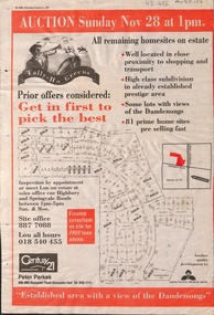
Newspaper - Article, Tally Ho Greens, 17/11/1993
Advertisement in the Post for auction of 81 home sites on the Tally Ho Estate.Advertisement in the Post for auction of 81 home sites on the Tally Ho Estate bordered by Springvale Road and Highbury Road, 28-11-1993.Advertisement in the Post for auction of 81 home sites on the Tally Ho Estate. auctions, springvale road, burwood east, highbury road, robinson drive, hoadley crescent, betts way, trainor place, sutton court, cole close, mcclelland way, kennard place, vision drive -
 Whitehorse Historical Society Inc.
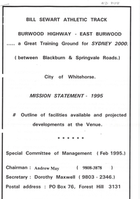
Document, Bill Sewart Athletic Track, 1995
Bill Sewart Athletic TrackBill Sewart Athletic Track Mission Statement - 1995Bill Sewart Athletic Track sportsgrounds, bill sewart athletic track, east burwood reserve, city of whitehorse, may, andrew, maxwell, dorothy -
Whitehorse Historical Society Inc.
Map, Highbury Road, c1970
Enlarged aerial photo of Highbury Park area.Enlarged aerial photo of Highbury Park area.Enlarged aerial photo of Highbury Park area.highbury road, burwood east, gareth drive, burwood east, blackburn road, burwood east, bennett avenue, burwood east, rae street, burwood east, joy street, burwood east, folkestone road, burwood east, burwood east primary school no. 454, aerial photographs -
 Whitehorse Historical Society Inc.
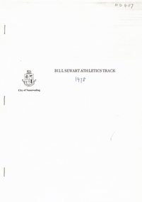
Document, Bill Sewart Athletic Track, 1978
Submission to City of Nunawading to construct an all-weather 400 metre athletics track.Submission to City of Nunawading to construct an all-weather 400 metre athletics track for the use of residents in the Nunawading district including supportive submissions from various bodies within the community, dated 1978.Submission to City of Nunawading to construct an all-weather 400 metre athletics track. sportsgrounds, city of nunawading, nunawading combined athletics committee, east burwood reserve, bill sewart athletic track, ralphsmith, john -
Whitehorse Historical Society Inc.
Map, Today's map of Mitcham, Nunawading, Blackburn, 1957
Folded detailed map of Mitcham, Nunawading, BlackburnFolded detailed map of Mitcham, Nunawading, BlackburnFolded detailed map of Mitcham, Nunawading, Blackburnmaps, mitcham, nunawading, blackburn, burwood east, forest hill, vermont -
Whitehorse Historical Society Inc.
Pamphlet, Neighbourhood activity in Nunawading, 1977
An attempt by the E.R.E.C. / ACCESS Community Education Project to increase the awareness of community activity and involvement in the municipality.An attempt by the E.R.E.C. / ACCESS Community Education Project to increase the awareness of community activity and involvement in the municipality. Includes maps of region showing community centres etc.An attempt by the E.R.E.C. / ACCESS Community Education Project to increase the awareness of community activity and involvement in the municipality. city of nunawading, east burwood recreation association, north blackburn community action group, vermont south community association, libraries, social services, emergency services -
Whitehorse Historical Society Inc.
Map, Parks and recreation facilities, 1/06/1995 12:00:00 AM
Map of the City of Whitehorse with parks and reserves marked and indexedMap of the City of Whitehorse with parks and reserves marked and indexed.Map of the City of Whitehorse with parks and reserves marked and indexedcity of whitehorse, parks and reserves, bicycle paths, recreation facilities, blackburn, blackburn north, blackburn south, burwood east, forest hill, mitcham, nunawading, vermont, vermont south -
Whitehorse Historical Society Inc.
Map, City of Whitehorse, 1/03/1995 12:00:00 AM
Map of City of Whitehorse prepared by Richard Meloni showing roads, railways, creeks.Map of City of Whitehorse prepared by Richard Meloni showing roads, railways, creeks.Map of City of Whitehorse prepared by Richard Meloni showing roads, railways, creeks.blackburn, nunawading, blackburn south, mitcham, vermont, vermont south, blackburn north, forest hill, burwood east, city of whitehorse -
Whitehorse Historical Society Inc.
Map, Heritage overlay map, 1/02/1999 12:00:00 AM
City of Whitehorse heritage review : Heritage overlay map.City of Whitehorse heritage review : Heritage overlay map.City of Whitehorse heritage review : Heritage overlay map.city of whitehorse, historic buildings, blackburn, blackburn south, blackburn north, mitcham, nunawading, forest hill, vermont, vermont south, burwood east -
Whitehorse Historical Society Inc.
Map, Shire of Blackburn and Mitcham, 1938
Plan of Shire of Blackburn and Mitcham showing sections and lot numbers. Scale 8 chains to 1 inch.Plan of Shire of Blackburn and Mitcham showing sections and lot numbers. Scale 8 chains to 1 inch.Plan of Shire of Blackburn and Mitcham showing sections and lot numbers. Scale 8 chains to 1 inch.shire of blackburn and mitcham, blackburn, blackburn north, blackburn south, burwood east, forest hill, mitcham, nunawading, vermont, vermont south -
Whitehorse Historical Society Inc.
Map, Shire of Blackburn and Mitcham, c1935
Map of Shire of Blackburn and Mitcham showing refuse collection days, sections and lot numbers. Scale 8 chains to 1 inch.Map of Shire of Blackburn and Mitcham showing refuse collection days, sections and lot numbers. Scale 8 chains to 1 inch.Map of Shire of Blackburn and Mitcham showing refuse collection days, sections and lot numbers. Scale 8 chains to 1 inch.shire of blackburn and mitcham, blackburn, blackburn north, blackburn south, burwood east, forest hill, mitcham, nunawading, vermont, vermont south -
Whitehorse Historical Society Inc.
Map, City of Nunawading, 1/02/1973 12:00:00 AM
Map of City of Nunawading shoeing open creeks or watercourses and watercourses that have been piped.Map of City of Nunawading shoeing open creeks or watercourses and watercourses that have been piped. Scale: 800 feet =1 inchMap of City of Nunawading shoeing open creeks or watercourses and watercourses that have been piped. blackburn, blackburn north, blackburn south, burwood east, forest hill, mitcham, nunawading, vermont, vermont south, city of nunawading, creeks -
Whitehorse Historical Society Inc.
Map, Shire of Blackburn and Mitcham, 10/10/1939 update
Map of Shire of Blackburn and Mitcham showing Departmental ball hydrants and departmental pillar ball hydrants.Map of Shire of Blackburn and Mitcham showing Departmental ball hydrants and departmental pillar ball hydrants. Scale 8 chains to 1 inch.Map of Shire of Blackburn and Mitcham showing Departmental ball hydrants and departmental pillar ball hydrants.shire of blackburn and mitcham, fire hydrants, blackburn, blackburn north, blackburn south, burwood east, forest hill, mitcham, nunawading, vermont, vermont south -
Whitehorse Historical Society Inc.
Article, Last days - schools close down
Last days - schools close down,Last days - schools close down, by Wendy Woods. Narmara Primary School and Blackburn Secondary College close. With photo of Narmara students. Discusses history of Blackburn Secondary College and amalgamation proposals.Last days - schools close down, primary schools, narmara primary school, burwood east, blackburn secondary college, secondary schools, blackburn technical school, mullauna secondary college -
Whitehorse Historical Society Inc.
Article, Three up for sale, 1991
Article on the sale of 244-276 Whitehorse Road and two other major propertiesArticle on the sale of 244-276 Whitehorse Road and two other major propertiesArticle on the sale of 244-276 Whitehorse Road and two other major propertieswhitehorse road, blackburn, nos 244-246, guests furniture, k-mart, east burwood -
Whitehorse Historical Society Inc.
Document, Scrapbooks, 1963 - 1990
Books of newspaper cuttings compiled for the Nunawading Historical Society 1963 - 1990.Books of newspaper cuttings compiled for the Nunawading Historical Society 1963 - 1990.Books of newspaper cuttings compiled for the Nunawading Historical Society 1963 - 1990.nunawading historical society, nunawading, mitcham, blackburn, vermont, burwood east, forest hill -
Whitehorse Historical Society Inc.
Document, Moorhouse Papers
Unpublished manuscript on history of the district of Nunawading 1857 - 1945. With index to Moorhouse Papers held by Nunawading City CouncilUnpublished manuscript on history of the district of Nunawading 1857 - 1945. With index to Moorhouse Papers held by Nunawading City CouncilUnpublished manuscript on history of the district of Nunawading 1857 - 1945. With index to Moorhouse Papers held by Nunawading City Councilmoorhouse, denice, city of nunawading, nunawading, blackburn, vermont, burwood east, mitcham, forest hill -
Whitehorse Historical Society Inc.
Map, Plan of the Parish of Nunawading, 1853
Photocopy of map showing names of selectors, also list of references to the corners of allotments.Photocopy of map showing names of selectors, also list of references to the corners of allotments. Note on verso:'Gardiners Creek, Ballyshanassey township surveyed by H. Parmein, Surveyor General's Office Nov 30, 1853 also Reference to the Corners of allotments' (Plan 428)Photocopy of map showing names of selectors, also list of references to the corners of allotments. land subdivision, gardiners creek, ballyshanassy, parmein, h, burwood east, maps -
Whitehorse Historical Society Inc.
Map, Parish of Nunawading, 1853
Photocopy of manuscript map with allotments numbered and named.Photocopy of manuscript map with allotments numbered and named. Note on verso: Parish of Nunawading, County of Bourke. Gardiners Creek, Ballyshanassey Township, surveyed by H. Parmein, Surveyor General's office, Nov 30th 1853 [enlargement of ND2801, no list of corner references]Photocopy of manuscript map with allotments numbered and named. maps, gardiners creek, ballyshanassy, burwood east, parmein, h -
Whitehorse Historical Society Inc.
Map, Nunawading Planning Scheme, 7/06/1994 12:00:00 AM
Local Section maps 1 - 4 with index. Geographical information system land Information Branch. Scale 1:10,000 Shows zoning under planning scheme.Local Section maps 1 - 4 with index. Geographical information system land Information Branch. Scale 1:10,000 Shows zoning under planning scheme.Local Section maps 1 - 4 with index. Geographical information system land Information Branch. Scale 1:10,000 Shows zoning under planning scheme.blackburn, blackburn north, blackburn south, forest hill, heatherdale, maps, nunawading, vermont, vermont south, town planning, burwood east, laburnum -
Whitehorse Historical Society Inc.
Book, Box Hill Reporter Cricket Association, 1994?
History of the Association, 1894 - 1994 with brief histories of some clubs.History of the Association, 1894 - 1994 with brief histories of some clubs.History of the Association, 1894 - 1994 with brief histories of some clubs.box hill reporter district cricket association, blackburn cricket club, blackburn north cricket club, blackburn south cricket club, box hill church of christ cricket club, box hill north cricket club, box hill pioneers cricket club, bulleen templestowe cricket club, burwood district cricket club, burwood heights uniting cricket club, coles myer cricket club, doncaster cricket club, east box hill cricket club, east burwood / bennettswood cricket club, eley park cricket club, forest hill cricket club, glen waverley hawks cricket club, glen waverley / northvale cricket club, heatherdale cricket club, koonung heights cricket club, mazenod old collegians cricket club, mitcham cricket club, mountain crusaders cricket club, nunawading cricket club, nunawading churches of christ cricket club, park orchards cricket club, st davids cricket club, syndal cricket club, vermont south cricket club, wheelers hill cricket club, yarraleen cricket club