Showing 8860 items matching " lake "
-
 Lakes Entrance Historical Society
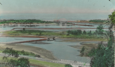
Postcard - Bullock Island Lakes Entrance, H D Bulmer, 1950 c
Bullock Island and first traffic bridge. Bullock Island has no development. North Arm bridge and Princes Highway in foreground, New Works area across Cunninghame Arm in distance Lakes Entrance Victoria. Also a cut down colour photograph of second humpy bridge to Bullock Island donated by M Fish number 04208.1 size 3 x 13 cm|Also two black and white photographs numbers 04208.2 and 04208.3 in SparesColour tinted postcard of Bullock Island and first traffic bridge. Bullock Island has no development. North Arm bridge and Princes Highway in foreground, New Works area across Cunninghame Arm in distance Lakes Entrance Victoria. Also a cut down colour photograph of second humpy bridge to Bullock Island donated by M Fish number 04208.1 size 3 x 13 cm|Also two black and white photographs numbers 04208.2 and 04208.3 in Spares Bullock Island and Bridge Lakes Entrance waterways, gippsland lakes, islands, vegetation -
 Lakes Entrance Historical Society
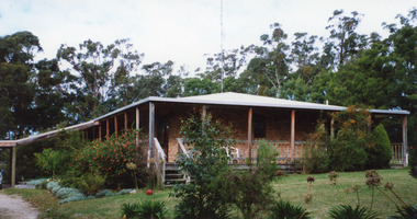
Photograph - Housing, 1999 c
Image used by King and Heath, Estate Agents: 'Home for Sale $199,500. (Lakes Post 29.9.1999)A colour photograph of a brick dwelling at 6 Henderson Road. House has hipped roof, veranda over front and side, five steps from the garden at front and carport at side. Toorloo Arm Victoriahouses, architecture -
 Lakes Entrance Historical Society
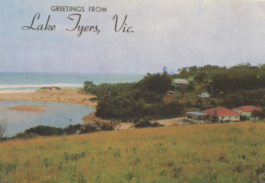
Postcard - Lake Tyers
Colour Photograph of Lake Tyers Beach and Kiosk, many people on the beach Greetings from Lake Tyers Vicboats and boating, forest, waterways, jetties, beaches -
 Lakes Entrance Historical Society
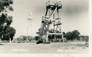
Postcard - Lookout tower Jemmy's Point, Bulmer H D, 1950
Black and white postcard of the timber lookout on Jemmys Point, with the signal light on steel tower nearby. Lakes Entrance Victoria,The Lookout, Lakes Entrancehistoric sites, navigation -
 Lakes Entrance Historical Society
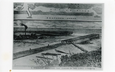
Photograph - Entrance Works, 1880c
Photographic reproduction of woodcut drawing of the building of the entrance and map above of location.Black and white photograph of a woodcut showing dredge working between timber constructed piers on entrance from the lakes to the ocean Bass Strait. Piers unfinished, timber lying around, sand in the entrance. Map above showing position of the lakes, old and new entrances, southern ocean and sand dune vegetation. Lakes Entrance VictoriaA woodcut depicting the making of the Lakes Entrance.public works, dredging, waterways -
 Lakes Entrance Historical Society
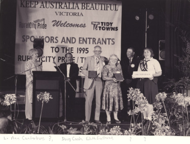
Photograph - Keep Australia Beautiful Lakes Tyers Beach, 1995
Black and white enlarged photograph of Doug Coole and Edith Juillerat and Ann Canterbury representing Lakes Tyers Beach community group entrants in 1995 Keep Australia Beautiful competition Lake Tyers Beach Victoria. Also a second black and white photograph taken at same event 05104.1 community, events, groups -
 Lakes Entrance Historical Society
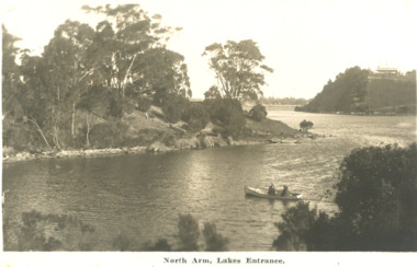
Postcard - North Arm Lakes Entrance Victoria. c1930, 1930 c
04324.1, 9 x 14 cmBlack and white postcard showing two people in a rowing boat on the lower reaches of the North Arm looking downstream Lakes Entrance Victoria c1930. Second black and white postcard of lower reaches of North Arm looking upstream Lakes EntranceNorth Arm Lakes Entrancewaterways, topography, vegetation -
 Ringwood and District Historical Society
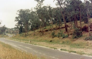
Photograph, Maroondah Highway East, Ringwood- 1969. Looking west towards Ringwood up from Ringwood Lake
Black and white photographImage shows Ringwood Mail Office on south side of Highway. -
 Ringwood and District Historical Society
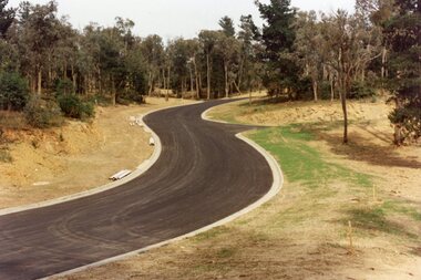
Photograph, View up the gully from Glenvale Road, North Ringwood towards the spot of the wall of Loughnan's Lake was
The brown undergrowth is on the remains of the walls, since levelled. Circa 1979. Part of a 51-photo record of the development of the "Kubis" Estate, Ringwood North, including road works to Debbie Place, Kubis Drive, Werac Drive, Manuelo Drive, Iluka Place and Glenvale Road. From the Jack Lundy Clarke collection. -
 Ringwood and District Historical Society
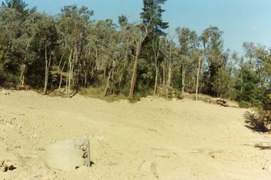
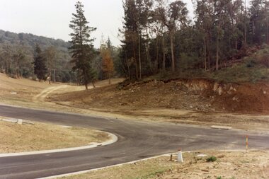
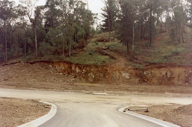
Photograph, Looking north down Werac Drive, North Ringwood with lake headwater's site behind light standard on left in February 1979
B552 N19 Part of a 51-photo record of the development of the "Kubis" Estate, Ringwood North, including road works to Debbie Place, Kubis Drive, Werac Drive, Manuelo Drive, Iluka Place and Glenvale Road. From the Jack Lundy Clarke collection. -
 Ringwood and District Historical Society
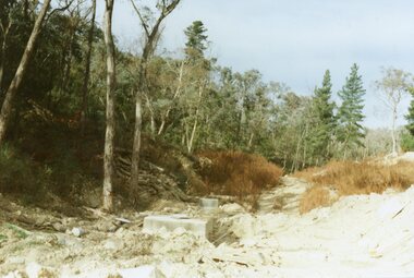
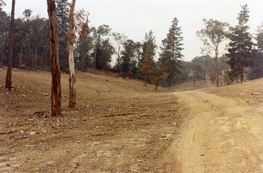
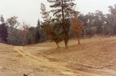
Photograph, Site of the main body of Loughnan's Lake, North Ringwood on 10 June 1978. the rope tree was on the slope, far left
E550 N6 Part of a 51-photo record of the development of the "Kubis" Estate, Ringwood North, including road works to Debbie Place, Kubis Drive, Werac Drive, Manuelo Drive, Iluka Place and Glenvale Road. From the Jack Lundy Clarke collection. -
 Ringwood and District Historical Society
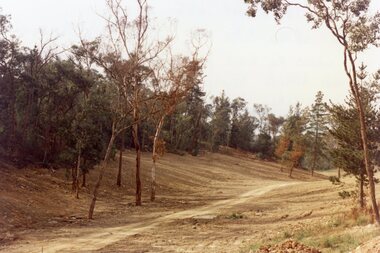
Photograph, Kubis Estate, North Ringwood in February 1978. The site of Loughnan's Lake seen from the north end of the wall. The rope tree was on the hillside on the left
E546 N2 Part of a 51-photo record of the development of the "Kubis" Estate, Ringwood North, including road works to Debbie Place, Kubis Drive, Werac Drive, Manuelo Drive, Iluka Place and Glenvale Road. From the Jack Lundy Clarke collection. -
 Ringwood and District Historical Society
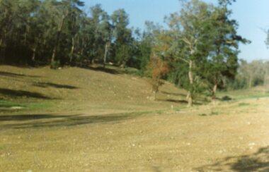
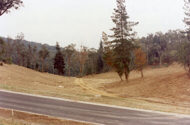
Photograph, Kubis Estate, North Ringwood in April 1978. Looking west across Kubis and Werac Drives over the full length of Loughnan's Lake site. Main pool was behind the lone pine
E548 N29 Part of a 51-photo record of the development of the "Kubis" Estate, Ringwood North, including road works to Debbie Place, Kubis Drive, Werac Drive, Manuelo Drive, Iluka Place and Glenvale Road. From the Jack Lundy Clarke collection. -
 Ringwood and District Historical Society
Photograph, Kubis Estate, North Ringwood in April 1978. Looking up the hill in Kubis Drive from the site of headwaters of Loughnan's Lake. Jenkins Close takes off to the right from centre
E548 N31 Part of a 51-photo record of the development of the "Kubis" Estate, Ringwood North, including road works to Debbie Place, Kubis Drive, Werac Drive, Manuelo Drive, Iluka Place and Glenvale Road. From the Jack Lundy Clarke collection. -
 Ringwood and District Historical Society
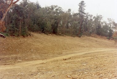
Photograph, Kubis Estate, North Ringwood in April 1978. Looking upstream from below the retaining wall of Loughnan's Lake that was where the truck tracks disappear. The wall was extended to the left across what was then a small gorge
E548 N19 Part of a 51-photo record of the development of the "Kubis" Estate, Ringwood North, including road works to Debbie Place, Kubis Drive, Werac Drive, Manuelo Drive, Iluka Place and Glenvale Road. From the Jack Lundy Clarke collection. -
 Ringwood and District Historical Society
Photograph, Kubis Estate, North Ringwood in April 1978. View of the lake site looking east. The wall was where the track bends. The rope tree was on the hillside beyond the track bend
E548 N35 This photo was taken from almost the same spot as the 1976 one. Part of a 51-photo record of the development of the "Kubis" Estate, Ringwood North, including road works to Debbie Place, Kubis Drive, Werac Drive, Manuelo Drive, Iluka Place and Glenvale Road. From the Jack Lundy Clarke collection. -
 Ringwood and District Historical Society
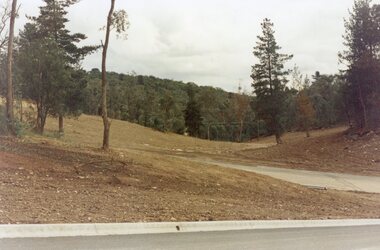
Photograph, Kubis Estate, North Ringwood in April 1978. Looking west over site of Loughnan's Lake. The rope tree was on the slope to the right beyond the ridge with the lone pine
E548 N15 Part of a 51-photo record of the development of the "Kubis" Estate, Ringwood North, including road works to Debbie Place, Kubis Drive, Werac Drive, Manuelo Drive, Iluka Place and Glenvale Road. From the Jack Lundy Clarke collection. -
 Ringwood and District Historical Society
Photograph, Loughnan Lake site over Kubis Drive, North Ringwood, on 14 April 1978. The retaining wall was where the car tracks disappear over the ridge where the spillway was
E548 N13 Part of a 51-photo record of the development of the "Kubis" Estate, Ringwood North, including road works to Debbie Place, Kubis Drive, Werac Drive, Manuelo Drive, Iluka Place and Glenvale Road. From the Jack Lundy Clarke collection. -
 Ringwood and District Historical Society
Photograph, "Kubis Estate", North Ringwood, in April 1978. Looking north-east over Loughnan's Lake greatest width. The rope tree was on the slope in the centre. The spillway was on the near left of the image
E548 N17 Part of a 51-photo record of the development of the "Kubis" Estate, Ringwood North, including road works to Debbie Place, Kubis Drive, Werac Drive, Manuelo Drive, Iluka Place and Glenvale Road. From the Jack Lundy Clarke collection. -
 Ringwood and District Historical Society
Photograph, Looking west across Werac and Kubis Drives, North Ringwood, in April 1978. Loughnan's Lake site. The retaining wall was where the truck tracks disappear over thhe ridge. The spillway was at that spot
E548 N3 Part of a 51-photo record of the development of the "Kubis" Estate, Ringwood North, including road works to Debbie Place, Kubis Drive, Werac Drive, Manuelo Drive, Iluka Place and Glenvale Road. From the Jack Lundy Clarke collection. -
 Ringwood and District Historical Society
Photograph, Looking from Werac Drive, North Ringwood, on 14th April 1978, across the site of the headwaters of Loughnan's Lake. Main body of water lay to the left (west)
E548 N7 Part of a 51-photo record of the development of the "Kubis" Estate, Ringwood North, including road works to Debbie Place, Kubis Drive, Werac Drive, Manuelo Drive, Iluka Place and Glenvale Road. From the Jack Lundy Clarke collection.51 -
 Ringwood and District Historical Society
Photograph, Looking west from Kubis Drive, North Ringwood, in April 1978, over the full length of the site of Loughnan's Lake
E548 N5 Part of a 51-photo record of the development of the "Kubis" Estate, Ringwood North, including road works to Debbie Place, Kubis Drive, Werac Drive, Manuelo Drive, Iluka Place and Glenvale Road. From the Jack Lundy Clarke collection.51 -
 Ringwood and District Historical Society
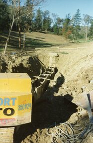
Photograph, The Kato working on the pumping plant at the end of the sewer trench near Glenvale Road, North Ringwood, on 10 June 1978. Loughnan's Lake site shown as a grassy hollow in the background
E550 N2 & N3 Part of a 51-photo record of the development of the "Kubis" Estate, Ringwood North, including road works to Debbie Place, Kubis Drive, Werac Drive, Manuelo Drive, Iluka Place and Glenvale Road. From the Jack Lundy Clarke collection.51 -
 Ringwood and District Historical Society
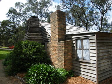
Photograph, Showing the exterior views of the facsimile of the miner's hut, located at the back of Ringwood Lake, from the original that once stood on Maroondah Highway in the 1870s onwards. The cottage was erected by the Ringwood City Council in conjunction with Ringwood Historical Research Group (now Ringwood & District Historical Society). Officially opened by Mayor Cr Pat Gotlib JP on 29th May 1983
Photographic record by Russ Haines, RDHS, in October 2008. -
 Ringwood and District Historical Society
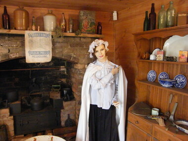
Photograph, Showing the interior views of the facsimile of the miner's hut, located at the back of Ringwood Lake, from the original that once stood on Maroondah Highway in the 1870s onwards. The cottage was erected by the Ringwood City Council in conjunction with Ringwood Historical Research Group (now Ringwood & District Historical Society). Officially opened by Mayor Cr Pat Gotlib JP on 29th May 1983
Photographic record by Russ Haines, RDHS, in October 2008. -
 Ringwood and District Historical Society
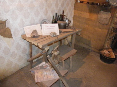
Photograph, Showing the tools and equipment rooms of the facsimile of the miner's hut, located at the back of Ringwood Lake, from the original that once stood on Maroondah Highway in the 1870s onwards. The cottage was erected by the Ringwood City Council in conjunction with Ringwood Historical Research Group (now Ringwood & District Historical Society). Officially opened by Mayor Cr Pat Gotlib JP on 29th May 1983
Photographic record by Russ Haines, RDHS, in October 2008. -
 Ringwood and District Historical Society
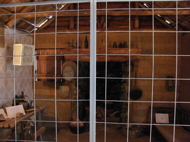
Photograph, Showing the living rooms of the facsimile of the miner's hut, located at the back of Ringwood Lake, from the original that once stood on Maroondah Highway in the 1870s onwards. The cottage was erected by the Ringwood City Council in conjunction with Ringwood Historical Research Group (now Ringwood & District Historical Society). Officially opened by Mayor Cr Pat Gotlib JP on 29th May 1983
Photographic record by Russ Haines, RDHS, in October 2008. -
 Ringwood and District Historical Society
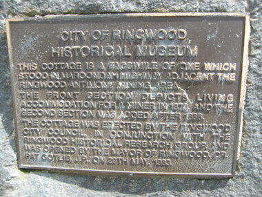
Photograph, The official plaque of the facsimile of the miner's hut, located at the back of Ringwood Lake, from the original that once stood on Maroondah Highway in the 1870s onwards. The cottage was erected by the Ringwood City Council in conjunction with Ringwood Historical Research Group (now Ringwood & District Historical Society). Officially opened by Mayor Cr Pat Gotlib JP on 29th May 1983
Photographic record by Russ Haines, RDHS, in October 2008. -
 Ringwood and District Historical Society
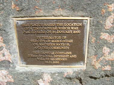
Photograph, The time capsule of the facsimile of the miner's hut, located at the back of Ringwood Lake, from the original that once stood on Maroondah Highway in the 1870s onwards. The capsule will be reopened on 28 January 2050. The cottage was erected by the Ringwood City Council in conjunction with Ringwood Historical Research Group (now Ringwood & District Historical Society). Officially opened by Mayor Cr Pat Gotlib JP on 29th May 1983
Photographic record by Russ Haines, RDHS, in October 2008. -
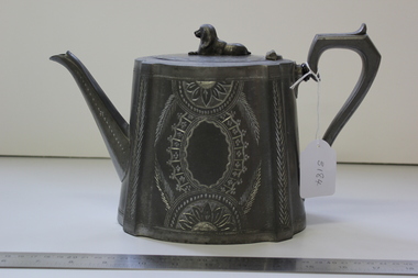 Ringwood and District Historical Society
Teapot, Antimony-based Britannia metal teapot - only display item recovered from replica Antimony Miner's Hut destroyed by fire at Ringwood Lake Park circa 2006, <1860
This teapot was donated to the Historical Society and placed in the Miner's Cottage display where it remained for several years. It was removed for cleaning and put in an archives display cabinet. The miner's cottage burnt down and thus the teapot is the only remaining object from the site.Teapot made of Britannia metal. Oval with recumbent dog on top. Insulated handle. Brilliant cut design on sides. Pouring spout and '7' shaped handle.On base: 8 Warranted best Britannia metal. Sheffield. 1204