Showing 1076 items
matching mason
-
 Ballarat Heritage Services
Photograph - Colour, Mason's Marks, Carlisle Cathedral, 27 October 2016
-
 Ballarat Heritage Services
Photograph - Colour, Mason's Marks, Carlisle Cathedral, 27 October 2016
-
 Ballarat Heritage Services
Photograph - Colour, Mason's Marks, Carlisle Cathedral, 27 October 2016
-
 Ballarat Heritage Services
Photograph - Colour, Mason's Marks, Carlisle Cathedral, 27 October 2016
-
 Ballarat Heritage Services
Photograph - Colour, Mason's Marks, Carlisle Cathedral, 27 October 2016
-
 Ballarat Heritage Services
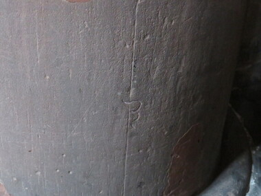
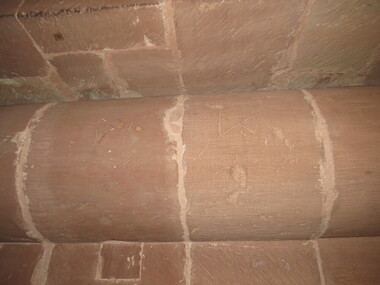
Photograph - Colour, Dorothy Wickham, Mason's Marks, Carlisle Cathedral, 27 October 2016, 2016
mason's mark, carlisle cathedral, stonemason -
 Ballarat Heritage Services
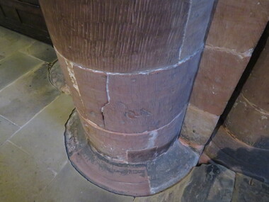
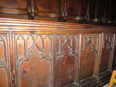
Photograph - Colour, Mason's Marks, Carlisle Cathedral, 27 October 2016, 2016
carlisle cathedral, mason's mark -
 Ballarat Heritage Services
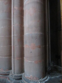
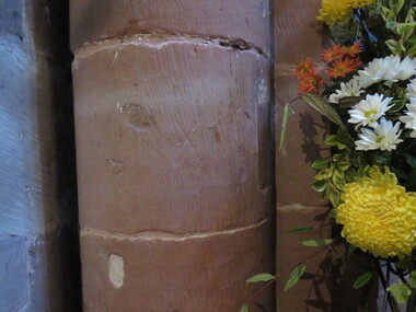
Photograph - Colour, Mason's Marks, Carlisle Cathedral, 27 October 2016, 2016
carlisle cathedral, stoenmason, mason's mark -
 Ballarat Heritage Services
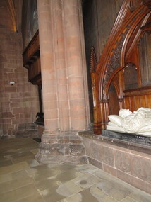
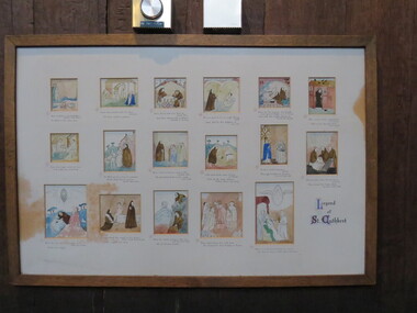
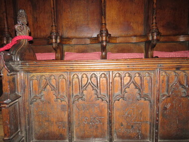
Photograph - Colour, Legend of St Cuthbert, Carlisle Cathedral, 27 October 2016, 2016
carlisle cathedral, masons marks -
 Ballarat Heritage Services
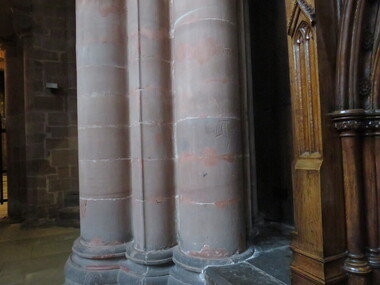
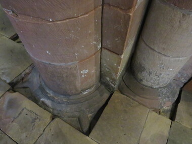
Photograph - Colour, Mason's Marks, Carlisle Cathedral 27 October 2016
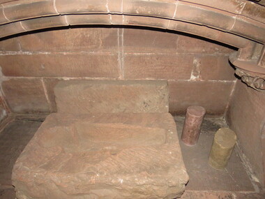
Carlisle and its cathedral. This cathedral church, which has stood on this site for over 800 years has a great story to tell. It is a story that can be traced back further still, to an even earlier church of the 7th century AD. Archaeological excavations on this site have taken the story back to Roman times. Today the dean and canons and other cathedral staff ensure that the worship of God remains the main work of this cathedral, while long-standing traditions of music, hospitality and education are also maintained. The story of this place is not so much about buildings, but about people. The buildings remain as evidence of the lives of people who lived and worked here and of what they believed and achieved. Until 1540 a community of Augustinian canons served the cathedral. They lived highly organized lives in monastic buildings suited to their needs. As canons rather than monks, they were freer to undertake pastoral and educational work. carlisle, cathedral, stonemasons, mason's marks -
 Ballarat Heritage Services
Photograph - Colour, Mason's Marks, Carlisle Cathedral 27 October 2016
Carlisle and its cathedral. This cathedral church, which has stood on this site for over 800 years has a great story to tell. It is a story that can be traced back further still, to an even earlier church of the 7th century AD. Archaeological excavations on this site have taken the story back to Roman times. Today the dean and canons and other cathedral staff ensure that the worship of God remains the main work of this cathedral, while long-standing traditions of music, hospitality and education are also maintained. The story of this place is not so much about buildings, but about people. The buildings remain as evidence of the lives of people who lived and worked here and of what they believed and achieved. Until 1540 a community of Augustinian canons served the cathedral. They lived highly organized lives in monastic buildings suited to their needs. As canons rather than monks, they were freer to undertake pastoral and educational work. carlisle, cathedral, stonemasons, mason's marks -
 Ballarat Heritage Services
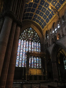
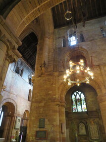
Photograph - Colour, Stained glass windows, Carlisle Cathedral 27 October 2016
Carlisle and its cathedral. This cathedral church, which has stood on this site for over 800 years has a great story to tell. It is a story that can be traced back further still, to an even earlier church of the 7th century AD. Archaeological excavations on this site have taken the story back to Roman times. Today the dean and canons and other cathedral staff ensure that the worship of God remains the main work of this cathedral, while long-standing traditions of music, hospitality and education are also maintained. The story of this place is not so much about buildings, but about people. The buildings remain as evidence of the lives of people who lived and worked here and of what they believed and achieved. Until 1540 a community of Augustinian canons served the cathedral. They lived highly organized lives in monastic buildings suited to their needs. As canons rather than monks, they were freer to undertake pastoral and educational work. carlisle, cathedral, stonemasons, mason's marks -
 Ballarat Heritage Services
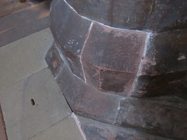
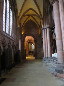
Photograph - Colour, Stonework, Carlisle Cathedral 27 October 2016
Carlisle and its cathedral. This cathedral church, which has stood on this site for over 800 years has a great story to tell. It is a story that can be traced back further still, to an even earlier church of the 7th century AD. Archaeological excavations on this site have taken the story back to Roman times. Today the dean and canons and other cathedral staff ensure that the worship of God remains the main work of this cathedral, while long-standing traditions of music, hospitality and education are also maintained. The story of this place is not so much about buildings, but about people. The buildings remain as evidence of the lives of people who lived and worked here and of what they believed and achieved. Until 1540 a community of Augustinian canons served the cathedral. They lived highly organized lives in monastic buildings suited to their needs. As canons rather than monks, they were freer to undertake pastoral and educational work. carlisle, cathedral, stonemasons, mason's marks -
 Ballarat Heritage Services
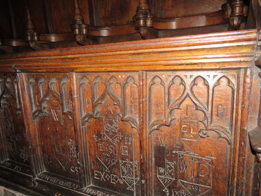
Photograph - Colour, Graffiti, Carlisle Cathedral 27 October 2016
Carlisle and its cathedral. This cathedral church, which has stood on this site for over 800 years has a great story to tell. It is a story that can be traced back further still, to an even earlier church of the 7th century AD. Archaeological excavations on this site have taken the story back to Roman times. Today the dean and canons and other cathedral staff ensure that the worship of God remains the main work of this cathedral, while long-standing traditions of music, hospitality and education are also maintained. The story of this place is not so much about buildings, but about people. The buildings remain as evidence of the lives of people who lived and worked here and of what they believed and achieved. Until 1540 a community of Augustinian canons served the cathedral. They lived highly organized lives in monastic buildings suited to their needs. As canons rather than monks, they were freer to undertake pastoral and educational work. carlisle, cathedral, stonemasons, mason's marks -
 Ballarat Heritage Services
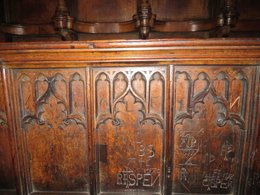
Photograph - Colour, Graffiti, Carlisle Cathedral (made 1500-1600)
Carlisle and its cathedral. This cathedral church, which has stood on this site for over 800 years has a great story to tell. It is a story that can be traced back further still, to an even earlier church of the 7th century AD. Archaeological excavations on this site have taken the story back to Roman times. Today the dean and canons and other cathedral staff ensure that the worship of God remains the main work of this cathedral, while long-standing traditions of music, hospitality and education are also maintained. The story of this place is not so much about buildings, but about people. The buildings remain as evidence of the lives of people who lived and worked here and of what they believed and achieved. Until 1540 a community of Augustinian canons served the cathedral. They lived highly organized lives in monastic buildings suited to their needs. As canons rather than monks, they were freer to undertake pastoral and educational work. Colour photograph of graffiti in a church.carlisle, cathedral, stonemasons, mason's marks, graffiti -
 Ballarat Heritage Services
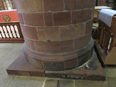
Photograph - Colour, Stonework, Carlisle Cathedral made 1500-1600
Carlisle and its cathedral. This cathedral church, which has stood on this site for over 800 years has a great story to tell. It is a story that can be traced back further still, to an even earlier church of the 7th century AD. Archaeological excavations on this site have taken the story back to Roman times. Today the dean and canons and other cathedral staff ensure that the worship of God remains the main work of this cathedral, while long-standing traditions of music, hospitality and education are also maintained. The story of this place is not so much about buildings, but about people. The buildings remain as evidence of the lives of people who lived and worked here and of what they believed and achieved. Until 1540 a community of Augustinian canons served the cathedral. They lived highly organized lives in monastic buildings suited to their needs. As canons rather than monks, they were freer to undertake pastoral and educational work. carlisle, cathedral, stonemasons, mason's marks -
 Ballarat Heritage Services
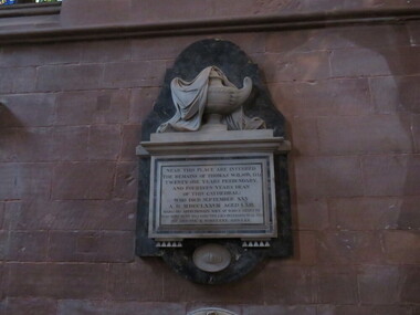
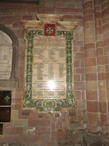
Photograph - Colour, Plaque for Border Regiment, Carlisle Cathedral
Carlisle and its cathedral. This cathedral church, which has stood on this site for over 800 years has a great story to tell. It is a story that can be traced back further still, to an even earlier church of the 7th century AD. Archaeological excavations on this site have taken the story back to Roman times. Today the dean and canons and other cathedral staff ensure that the worship of God remains the main work of this cathedral, while long-standing traditions of music, hospitality and education are also maintained. The story of this place is not so much about buildings, but about people. The buildings remain as evidence of the lives of people who lived and worked here and of what they believed and achieved. Until 1540 a community of Augustinian canons served the cathedral. They lived highly organized lives in monastic buildings suited to their needs. As canons rather than monks, they were freer to undertake pastoral and educational work. carlisle, cathedral, stonemasons, mason's marks -
 Ballarat Heritage Services
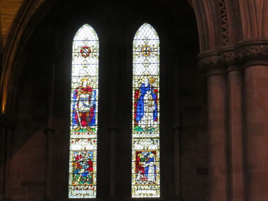
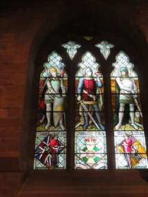
Photograph - Photograph - Colour, Stained glass window, Carlisle Cathedral
Carlisle and its cathedral. This cathedral church, which has stood on this site for over 800 years has a great story to tell. It is a story that can be traced back further still, to an even earlier church of the 7th century AD. Archaeological excavations on this site have taken the story back to Roman times. Today the dean and canons and other cathedral staff ensure that the worship of God remains the main work of this cathedral, while long-standing traditions of music, hospitality and education are also maintained. The story of this place is not so much about buildings, but about people. The buildings remain as evidence of the lives of people who lived and worked here and of what they believed and achieved. Until 1540 a community of Augustinian canons served the cathedral. They lived highly organized lives in monastic buildings suited to their needs. As canons rather than monks, they were freer to undertake pastoral and educational work. carlisle, cathedral, stonemasons, mason's marks -
 Ballarat Heritage Services
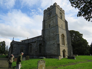
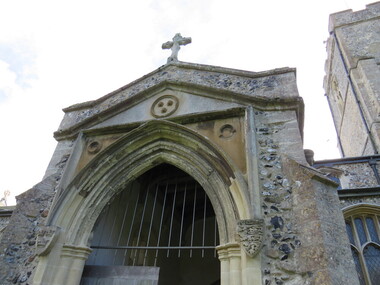
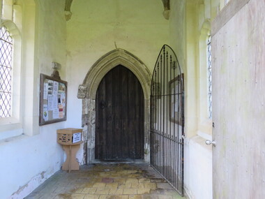
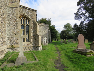
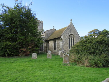
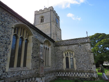
Photograph - Colour, St Mary's Church, Dullingham
St Mary's Dullingham is a parish in the Raddesley Benefice. st mary's, dullingham, church, england, dullingham church pond, elizabeth symonds, stonework, masons, stonemasons, graves -
 Ballarat Heritage Services
Photograph - Colour, St Mary's Church, Dullingham
St Mary's Dullingham is a parish in the Raddesley Benefice. st mary's, dullingham, church, england, dullingham church pond, elizabeth symonds, stonework, masons, stonemasons, graves -
 Ballarat Heritage Services
Photograph - Colour, St Mary's Church, Dullingham
St Mary's Dullingham is a parish in the Raddesley Benefice. st mary's, dullingham, church, england, dullingham church pond, elizabeth symonds, stonework, masons, stonemasons, graves -
 Ballarat Heritage Services
Photograph - Colour, St Mary's Church, Dullingham
St Mary's Dullingham is a parish in the Raddesley Benefice. st mary's, dullingham, church, england, dullingham church pond, elizabeth symonds, stonework, masons, stonemasons, graves -
 Ballarat Heritage Services
Photograph - Colour, St Mary's Church, Dullingham
St Mary's Dullingham is a parish in the Raddesley Benefice. st mary's, dullingham, church, england, dullingham church pond, elizabeth symonds, stonework, masons, stonemasons, graves -
 Ballarat Heritage Services
Photograph - Colour, St Mary's Church, Dullingham
St Mary's Dullingham is a parish in the Raddesley Benefice. st mary's, dullingham, church, england, dullingham church pond, elizabeth symonds, stonework, masons, stonemasons, graves