Showing 10391 items
matching plans
-
 University of Melbourne, Burnley Campus Archives
Plan - Plan, aerial photograph, Works Plan Scale 1:2000 [Aerial photograph of quarry]
In pencil on back of photograph: Lilydale Quarry Grid & a photolilydale, quarry -
 Melton City Libraries
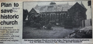
Newspaper, Plan to save historic church, 1993
Plans to save the Anglican Church in Meltonchurches, local architecture -
University of Melbourne, Burnley Campus Archives
Plan, BHP Plaza 120 Collins St Melbourne, c. 1990
Possibly student workSketch plan. Scale 1:100.bhp, architecture -
 Whitehorse Historical Society Inc.
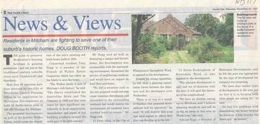
Article, Walker Estate, 22/11/1997 12:00:00 AM
Luther College Year 10 History assignment Residents in Mitcham are fighting to save one of their suburb's historic homes.Residents in Mitcham are fighting to save one of their suburb's historic homes. More than 60 objections have been received by the City of Whitehorse Planning Office to an application by Metrospan Developments to build 16 double storey units at 456 - 460 Mitcham Road, Mitcham. The proposed development is on part of the historic Walker Estate.Luther College Year 10 History assignment Residents in Mitcham are fighting to save one of their suburb's historic homes. walker estate, hogg, tony, australian tesselated tile co. pty ltd, allan, peter, buckingham, helen, rigo, anthony, metrospan developments -
 Kew Historical Society Inc
Plan, F R Simms & Son, Land for Private Sale: Cnr Victor Avenue and Mont Victor Road, Kew, 1950-1960
George Rimington established The Parkhill Nursery in 1877. By 1910, it was more commonly known as Rimington’s Nurseries and well known for its sale of violets. After World War II, Rimington’s Nurseries were gradually subdivided and sold. The 38 allotments were released in sections, including lots 34 to 36 on the corner of Mont Victor Road and Victor Avenue. Previous lots in the subdivision had bordered Burke Road, Rimington Avenue, Heather Grove, and Stoke Avenue. The selling point as it had been in comparable estates for a century were the proximity to transport, schools and churches, as well as the high location and excellent views. The subdivision plan shows most of the lots in the entire subdivision: 1-11, 13-26, and 34-38. Presumably, lot 12 and lots 27-33 were still to be released.Subdivision plans are historically important documents used as evidence of the growth of suburbs in Australia. They frequently provide information about when the land was sold on which a built structure was subsequently constructed as well as evidence relating to surveyors and real estate and financial agents. The numerous subdivision plans in the Kew Historical Society's collection represent working documents, ranging from the initial sketches made in planning a subdivision to printed plans on which auctioneers or agents listed the prices for which individual lots were sold. In a number of cases, the reverse of a subdivision plan in the collection includes a photograph of a house that was also for sale by the agent. These photographs provide significant heritage information relating house design and decoration, fencing and household gardens.Subdivision plan advertising five superb home sites among lots in Burke Road, Stoke Avenue, Victor Avenue, Mont Victor Road and Heather Grove.subdivision plans - kew, rimington avenue -- kew (vic.), heather grove -- kew (vic), stoke avenue -- kew (vic.), burke road -- kew (vic.), mont victor road -- kew (vic.) -
Glen Eira Historical Society
Plan - Oswald Street, 6/17, Elsternwick
... Plans ...Copy of letter to Mr. and Mrs. J.M. Cunningham from sworn valuator W.V. Scott regarding detailed valuation of 6/17 Oswald Street Gardenvale dated 27 September 1977. Handwritten notes and plan recording the measurements of all the rooms. A cover copy letter to Mr. and Mrs. J.M. Cunningham from W.V. Scott 27 September 1977 with handwritten notes.cunningham j.m., oswald street, elsternwick, home units, verandahs, plans, brick houses, scott. w.v., bay windows, valuation -
Port Melbourne Historical & Preservation Society
Book, Making the Most of the Bay, Apr 1989
'Making the Most of the Bay'- a draft plan for the protection and development of Port Phillip and Corio Bays, 1989. A draft plan to guide decision making. Introduction by Tom Roper, Minister for Planning and Development. (Refer item 1048, final version)state government victoria, natural environment - conservation, town planning -
 University of Melbourne, Burnley Campus Archives
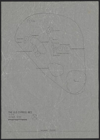
Plan, The Old Cypress Bed, 1987-1993
(1) Plant plan dated 15.8.1987 on tracing paper, and plan of bed only. (2) Site inventory and analysis Group 3 Parks and Gardens III August 1993, on tracing paper. (3) Rough plant plan in pencil.gardens, cypress -
University of Melbourne, Burnley Campus Archives
Work on paper (item) - Student Work, Sandra Brizga, Andembach - Riverside Garden Planting Plan, 8 November 2018
Made as an assignment for HORT90035, a subject at Burnley Horticultural College coordinated by Andrew Laidlaw. assignment, burnley horticultural college, hort90035 -
 Kew Historical Society Inc
Plan - Subdivision Plan, Kew Golf Links Estate, 1936, 1936
The Kew Golf Links Estate was a major subdivision in North Kew. It derived its title due to the land being previously occupied by the Kew Golf Club, which transferred its course to a number of locations before occupying its current site. The Plan advertises 180 choice home sites. The street names are somewhat different today as those on the map are named after the proposed Kodak Factory to be built on the site. The subdivision of the Kew Golf Links Estate was a major subdivision of farmland in Kew. The site was at one stage designated for industrial development and the building of a new Kodak factory. The decision by Council to oppose the redevelopment makes the beginning of the period when all industrial development was banned in Kew.Monochrome printed, folded subdivision plan for the Kew Golf Links Estate, to be auctioned on 7 November 1936. Streets named include: Carnegie Avenue, Willsmere Road, Kilby Boulevarde, Kodak Avenue, Coleman Avenue, Beresford Avenue, McConchie Avenue, Cole Avenue, White Avenue, Baker Avenue, Spruzen Avenue, Tanner Avenue, Ratten Avenue, Mathers Avenue, Railway Avenue, Sutherland Avenue, and Belford Road. The position of the Yarra River and a large Drainage Reserve are marked on the plan. Lots for sale are numbered. Existing buildings are designated with a square.subdivision plans - kew (vic), kodak factory - kew (vic) -
 Melbourne Tram Museum
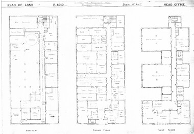
Drawing, Melbourne & Metropolitan Tramways Board (MMTB), "Head Office", c1938
Set of three photocopied plans or drawings on A3 sheet of "Head Office" - c1937 .1 - P8643 - Plan showing Basement, Ground Floor and First Floor - shows MCC substation location in basement. .2 - P8644 - Plan showing Second, Third and fourth floors .3 - P8394 - Plan showing firth floor and roof, with lift rooms.trams, tramways, drawings, depots, property, head office, mmtb, substation -
 Ringwood and District Historical Society
Manual, Southwood Primary School, Ringwood - Evacuation Procedure Manual (undated - circa - post 1983)
Bound Manual describing evacuation and emergency procedures. Includes Action Plan, Staff members, Instructions, Types of Threats and school building plan -
Lara RSL Sub Branch
Education Package, Anzac Centenary Corcmmunity Resource Guide
The Community Resource Guide helps you plan a commemorative event in Victoria and share Local stories as part of the planning for ANZAC Centenary celebrationsPart 1 includes elements of a commemorative service and preserving precious memorabilia Part 2 includes Victoria's roll in the History of World War One. Also included are capsule stories of the men who were awarded the Victoria Cross for outstanding valour -
 Bendigo Historical Society Inc.
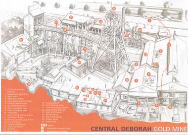
Document - CENTRAL DEBORAH GOLD MINE: PLAN OF SURFACE FEATURES OF MINE
Two copies of a plan of the Central Deborah Gold Mine. Features on the surface of the mine are drawn, labelled and described. Plan printed in orange and grey.bendigo, mining, central deborah gold mine -
Lakes Entrance Regional Historical Society (operating as Lakes Entrance History Centre & Museum)
Book, Town and Country Planning Board Melbourne, Gippsland Lakes Strategy, 1978
A strategy plan to guide future development of the Gippsland Lakes in a rational manner, to benefit all residents and visitors to the area. Contains plans and mapsgovernment, community facilities, recreation -
Clunes Museum
Document - REPORT, NADIA GASPARETTO et al, CLUNES TOWN HALL AND COURT HOUSE CONSERVATION PLAN, MAY 2000
THE HISTORY AND CONSERVATION POLICY IS AIMED AT RETAINING AND CONSERVING THE BUILDINGCONSERVATION PLAN OF CLUNES TOWN HALL AND COURT HOUSE COMPILED BY NADIA GASPARELTO , ARCHITECT AND HEPBURN SHIRE COUNCIL, INCLUDING PLAN OF BUILDINGLIST OF ILLUSTRATIONS AND PHOTOSclunes town hall, clunes courthouse -
Whitehorse Historical Society Inc.
Article, Council services awards, 1996
Whitehorse Council has received a commendation award for planning excellence from the Royal Australian Planning Institute for the review of the community grants program.Whitehorse Council has received a commendation award for planning excellence from the Royal Australian Planning Institute for the review of the community grants program.Whitehorse Council has received a commendation award for planning excellence from the Royal Australian Planning Institute for the review of the community grants program.city of whitehorse, awards, royal australian planning institute -
Whitehorse Historical Society Inc.
Map, Anjaya Court, Blackburn, ca1970
[Plan of] Anjaya Court, Blackburn, Lots 6 - 20and of Leons Court, Lots 21-24. One copy with proposed sewerage plan.anjaya court, blackburn, land subdivision, sewerage and sanitation -
 Bendigo Historical Society Inc.
Document - BERT GRAHAM COLLECTION: BENDIGO EAST SWIMMING CLUB
Plans, Bert Graham Collection, Bendigo East Swimming Club, Plan for the construction of the Kiosk. This item quite large and has not been scanned.bendigo, clubs, bendigo east swimming pool -
 Bendigo Historical Society Inc.
Plan - BERT GRAHAM COLLECTION: BENDIGO EAST SWIMMING POOL
Plans, Bert Graham Collection, Bendigo East Swimming Pool, 2 plans for the Kiosk. This item is quite large and has not been scanned.bendigo, clubs, bendigo east swimming pool -
 Bendigo Historical Society Inc.
Plan - BERT GRAHAM COLLECTION: BENDIGO EAST SWIMMING POOL
Plans, Bert Graham Collection, Bendigo East Swimming Pool, plans for the Pool. 4 quite large sheets too big to scan.bendigo, clubs, bendigo east swimming pool -
University of Melbourne, Burnley Campus Archives
Plan - Photocopy, Jan Horner, 24 Selbourne Road Toorak Concept Plan, 2000
Photocopy of plans by Jan Horner, 16 December 2000. Scale 1:50. (1) Concept Plan. (2) One Point Perspective.jan horner, toorak, garden design -
University of Melbourne, Burnley Campus Archives
Work on paper (item) - Student Work, Annabel Dungey, Birch Tree Residence Project, 2018
assignment, burnley horticultural college -
University of Melbourne, Burnley Campus Archives
Work on paper (item) - Student Work, Perry Lane, Glenlyon RD Landscape Design, Uncertain, probably 2017-2018
Submitted as an assignment for HORT90035, 'Landscape Construction and Graphics,' a subject at Burnley Horticultural College coordinated by Andrew Laidlaw. It seems a third sheet of paper is missing, though one of the folders does contain a rubric showing the mark received for this project. assignment, landscaping, burnley horticultural college, landscape construction and graphics, hort90035 -
Canterbury History Group
Ephemera - A magical reminder of an enchanting era, 1991
Real estate advertisement for the sale by auction on 9 September 1991 of 138 Canterbury Road Canterbury. Includes floor plans and site plans.canterbury, canterbury road, marlowe street, federation style -
Glen Eira Historical Society
Plan - Yeshivah & Beth Rivkah College
... Plans ...This file contains a set (incomplete) of 7 architectural drawings prepared by architects Synman Justin Balek and Best Overend and Partners - Existing site and Master Plan o - Primary School Administration and Community Facility - Synagogue Refurbishment 2 - Multipurpose Hall 3 - Glenferrie Property – Refurbishment of Residence 5 – Glenferrie Property - New Kindergarten 6 - Another Property Refurbishment of Residence 7school, plans, saint kilda east, independent school, architects, hotham street, yeshivah and beth rivkah college, synman justin balek, balaclava road, best overend & partners -
Whitehorse Historical Society Inc.
Article, A Living, working view of our heritage, 1992
Matheson's Orchard, the last working orchard in NunawadingMatheson's Orchard, the last working orchard in Nunawading will soon be open to the public. Council purchased the orchard in 1988. The plan is to run the orchard as it would have operated in the 1930's providing a living and working view of Nunawading's heritage. The eldest child, Marjory, wife of Rev Rhys miller is writing a history of the orchard for Council.Matheson's Orchard, the last working orchard in Nunawading orchards, matheson, charles, city of nunawading -
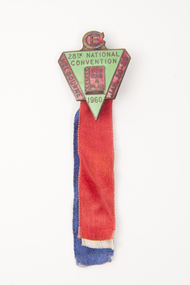 Uniting Church Archives - Synod of Victoria
Badge
Green and red triangular shaped badge on red, blue and white ribbons."CE" "20th National Convention 1960" "God has a plan" "Melbourne Jan - 20 - 28" -
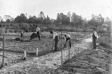 University of Melbourne, Burnley Campus Archives
Photograph - Black and white print, Noelle Kendall (Vaughan), Reconstructing the Vegetable Garden May 1918, 1918
2 copies black and white photograph. Copy of photograph in Noelle Kendall's (née Vaughan) photograph album (B09.0003). 3 men and a child working in the vegetable section of the Orchard. Wooden wheelbarrow. Male teacher supervising.On reverse, "Re-planning vegetable garden May 1918. Man supervising could be George Russ."noelle kendall (née vaughan), vegetable garden, george russ, students working outside, orchard, wheelbarrow -
Dandenong/Cranbourne RSL Sub Branch
Memorabilia - Framed Military Memorabilia
Wooden frame containing Military Memorabilia.Pamphlet "Tobruk to Borneo". Newspaper cutting "Old soldier Tom VC plans a quiet toast".