Showing 2559 items
matching aerial
-
 Glenelg Shire Council Cultural Collection
Photograph - Photograph - Cape Grant Quarry, 14/01/1958
Port of Portland Authority ArchivesBack: Purple PHT stamp '14 JAN 1958'port of portland archives, cape grant quarry -
Glenelg Shire Council Cultural Collection
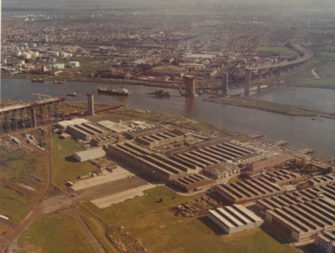
Photograph - Photograph - aerial view of Portland, 1970
Black and white aerial view of central Portland 1970. Image depicts residential areas in foreground and Portland Harbour in background. Framedaerial photography, central portland, portland harbour, residential -
Glenelg Shire Council Cultural Collection
Photograph - Photograph - Portland Harbour, 1958
Port of Portland Authority ArchivesBack: "L - R" - top left pencil. Purple Stamp - TOP RIGHT "17 Nov 1958"port of portland archives, portland harbour, bentinck street, all saints, foreshore, 1958 -
Glenelg Shire Council Cultural Collection
Photograph - Photograph -K.S Anderson Wharf, n.d
Port of Portland Authorityport of portland archives, k s anderson wharf -
Glenelg Shire Council Cultural Collection
Pamphlet - Folder - Welcome to Portland, c. 1980
Glenelg Shire Council Records Dept.Front: Welcome to Portland growth area in the 80's Back: Photograph courtesy of Portland Harbour Trust. Printed by E. Davis & Sons Pty. Ltd. Portland 3305 -
 Port Melbourne Historical & Preservation Society
Photograph - Aerial view of West Gate Bridge under construction, 1960 - 1979
Colour aerial photograph of West Gate Bridge under construction. Fishermans Bend factories in foreground. Ship in the river and view to Williamstown"Master copy. Not to be removed from marketing Department" stamped on top right corner and on backtransport, engineering, engineering - bridges, fishermans bend, industry, west gate bridge, rotten row, williamstown, yarra river -
Port Melbourne Historical & Preservation Society
Postcard - John Kitchen series, aerial view of J Kitchen & Sons Pty Ltd, David Thompson et al, Nov 1916
PMHPS - John Kitchen series of six coloured postcards .03 - black and white aerial view of J Kitchen & Sons siteindustry - manufacturing, business and traders - soaps/candles, built environment - industrial, j kitchen & sons pty ltd -
Port Melbourne Historical & Preservation Society
Photograph - Aerial view of HMS Hood, Port Phillip Bay, Royal Australian Air Force (RAAF), 1924
Air Force aerial photos of the visit of HMS Hood and HMS Repulse 1924 01 - HMS Hood coming up the baypiers and wharves - princes pier, transport - shipping, armed services - navy, hms hood, hms repulse, ss james patterson -
Port Melbourne Historical & Preservation Society
Photograph - Aerial view of Port Melbourne, 1931
Section of aerial photograph of Port Melbourne c1931 (refer item 574), covering Beach to Spring Street and Lagoon to Lyons Streetsandridge lagoon, built environment -
National Vietnam Veterans Museum (NVVM)
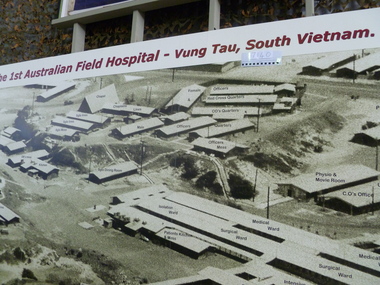
Document, The First Australian Field Hospital
Framed Document featuring an Aerial Photograph of the hospital compound with buildings. Identified photograph is surrounded by the history of the hospitals, admission and service statistics.Variousframed document, first australian field hospital, vung tau -
 National Vietnam Veterans Museum (NVVM)
Photograph, 1 Aust FD Hospital Vung Tau South Vietnam
Aerial photograph wall panel of 1 Aust Field Hospital Vung Tau, features layout and labelled building of hospital complex1 Australian Field Hospital Vung Tau South Vietnam1st australian field hospital -
Clunes Museum
Photograph, EXTENT OF MINE WORKINGS AT CLUNES, 1987
MINE WORKINGS IN CLUNESAERIAL PHOTOGRAPH CLUNES GOLD WORKINGS MAP SUPERIMPOSED. MOUNTED ON CARDBOARD WITH DETAILS OF MINE LOCATION. TYPED DESCRIPTION PASTED BELOW.port phillip mine, aerial photograph, quartz mining -
 Hume City Civic Collection
Photograph, c 1968
The Melbourne Airport at Tullamarine was constructed during the latter half of the 1960s and was officially opened in 1970.An aerial view of the recently completed airport at Tullamarine showing the Astrojet Centre and the motel under construction in the foreground. The terminal building is in the background.goonawarra farm, goonawarra golf club, goonawarra housing estate, sharkey, robert b., kilkenny homes, villa bella homes, australian ideas homes pty.ltd., glamor homes, craftsmen homes., george evans collection -
Whitehorse Historical Society Inc.
Map, Springvale Road, 1981
Aerial photograph of area including cnr. Springvale Road and Burwood Highway, south past Highbury Road and west to Sevenoaks Road.Aerial photograph of area including cnr. Springvale Road and Burwood Highway, south past Highbury Road and west to Sevenoaks Road.Aerial photograph of area including cnr. Springvale Road and Burwood Highway, south past Highbury Road and west to Sevenoaks Road.aerial photographs, burwood east, springvale road, burwood east, burwood highway, burwood east, sevenoaks road, burwood east, highbury road, burwood east -
Whitehorse Historical Society Inc.
Map, Springvale Road, 1975
Aerial photograph of area around cnr. of Springvale Road and Burwood Highway, south past Highbury Road and East in Vermont South.Aerial photograph of area around cnr. of Springvale Road and Burwood Highway, south past Highbury Road and East in Vermont South.Aerial photograph of area around cnr. of Springvale Road and Burwood Highway, south past Highbury Road and East in Vermont South.aerial photographs, vermont south, highbury road, burwood east, burwood highway, burwood east, burwood east -
 8th/13th Victorian Mounted Rifles Regimental Collection
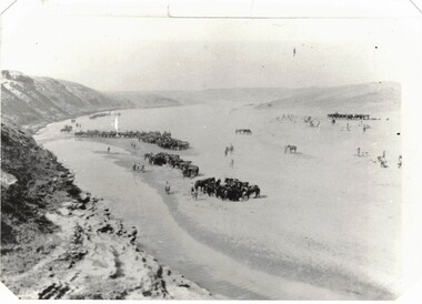
Photograph - 8th LH in desert
The 8th Light Horse Regiment AIF was raised at Broadmeadows Victoria in September 1914 under the command of Lieutenant Colonel Alexander White and formed part of the 3rd Light Horse Brigade. The regiment served at Gallipoli where in a courageous but ill-fated charge at the Nek on 7 August 1915 it suffered horrendous casualties including Lieutenant Colonel White. Rebuilt in Egypt under the command of Lieutenant Colonel Leslie Maygar VC the regiment went on the serve throughout the Middle East Campaign. Colonel Maygar died of wounds at Beersheba when the regiment was attacked by enemy aircraft while waiting to follow up the successful charge of the 4th LH Brigade on 30 October 1917. The 8th Light Horse AIF was disbanded in 1919, but soon after re-raised as the 8th (Indi) Light Horse in the Citizen Military Forces, superseding 16th (Indi) Light Horse. Aerial black and white photograph of light horse regiment in desert. Thought to be 8th Australian Light Horse (AIF) c.1917.8th, light horse, world war one, wwi, middle east -
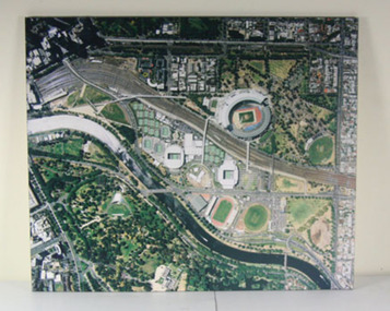 Tennis Australia
Print, 2006
Pair of photopgrahic images, mounted on foamboard. Aerial images of Melbourne Park on 24 Januuary 2006, by Skyfast. Materials: Paper, Foamcoretennis -
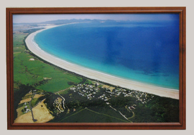 South Gippsland Shire Council
Photograph, Framed, 2003
Framed colour photograph featuring an aerial view of Waratah Bay, the beach and Sandy Point . Wilsons Promontory can be seen in the distance. -
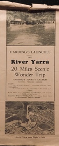 Kew Historical Society Inc
Flyer, Melbourne Ferries Pty Ltd, River Yarra: 20 Miles Scenic Wonder Trip
Bifold brochure including route map of the full 44 mile 'Wonder Trip' on pages 2 & 3. Photos used include an 'Aerial view over Dight's Falls', two ferries, and a 'Scene near Dight's Falls'.Flyer for Harding’s Launches on the River Yarra: 20 miles scenic wonder trip. Aerial view over Dight’s Falls on front. non-fictionBifold brochure including route map of the full 44 mile 'Wonder Trip' on pages 2 & 3. Photos used include an 'Aerial view over Dight's Falls', two ferries, and a 'Scene near Dight's Falls'.river yarra, melbourne ferries pty ltd, yarra river -- tourism, harding's cruises, christian-washfold collection -
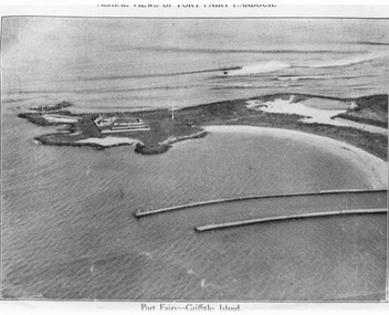 Port Fairy Historical Society Museum and Archives
Photograph, C. 1925
Black and white arial photograph of the Moyne river entrance, the original signed by R.W.Golding.Black and white aerial photograph of Griffith island showing the lighthouse keeper’s compound, the large flagstaff and the river training walls in the foregroundHand written on the back "Port Fairy Moyne River Entrance R. W. Golding Handwritten on the back of the copy "Port Fairyb Harbour 1925"local history, photography, photographs, slides, film, arial, moyne river -
 City of Kingston
Photograph - Black and white, c. 1950
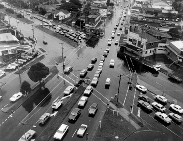
The image shows a line of traffic travelling along South Road in response to traffic light signlas while an increasing number of cars are banking up along Nepean Highway, also in response to traffic light signals.This image provides a strong contrast to images from earlier eras of the same intersection. The amount of traffic has increased enormously as well as commercial development.Black and white photograph with an aerial view of the intersection of Nepean Highway and South Road, taken from above the Moorabbin Council Chambers.Handwritten in black ink Pic [indecipherable] / 1000 Handwritten in red ink: 150%moorabbin, traffic lights, cars, nepean highway -
 Lakes Entrance Historical Society
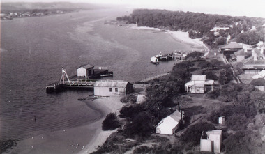
Photograph - New Works
Black and white photograph showing aerial view of Works buildings and cottages near man-made entrance to Gippsland Lakes Victoria boats and boating, topography, settlement, historic buildings -
 Lakes Entrance Historical Society
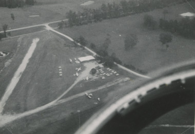
Photograph - Lakes Entrance, Lakes Post Newspaper, 1/01/1993 12:00:00 AM
DCNR Crews from Bairnsdale Swifts Creek and Nowa Nowa training at Campbell's AirfieldBlack and white aerial photograph of Campbell's Airfield Colquhoun Road showing planes and vehicles near hanger Lakes Entrance Victoriaaerial photograph, township -
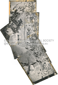
 Eltham District Historical Society Inc
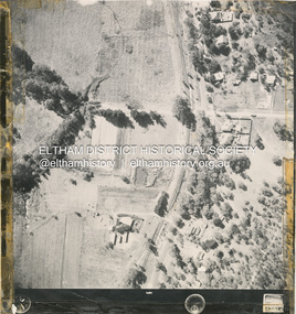
Photograph - Aerial Photograph, Main Road Hurstbridge, corner of Rose Ave, 12 Apr. 1954
Victorian Railways Aerial Surveyshire of eltham archives, aerial photo, main road, anzac avenue, hursbridge, parker road, hurstbridge railway station, rose road -
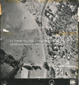
 Eltham District Historical Society Inc
Photograph - Aerial Photograph, Main Road, Hurstbridge; Rose Road to Anzac Avenue including Railway Station area, 12 Apr. 1954
Victorian Railways Aerial Surveyshire of eltham archives, aerial photo, main road, anzac avenue, hursbridge, parker road, hurstbridge railway station, rose road -
 Eltham District Historical Society Inc
Photograph - Aerial Photograph, Main Road Hurstbridge, Rose Ave to Parker Road, 12 Apr. 1954
Victorian Railways Aerial Surveyshire of eltham archives, aerial photo, main road, anzac avenue, hursbridge, parker road, hurstbridge railway station, rose road -
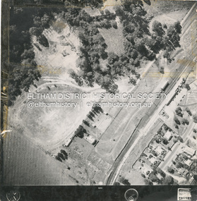 Eltham District Historical Society Inc
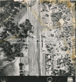
Photograph - Aerial Photograph, Main Road and Railway Station area, Hurstbridge, 12 Apr. 1954
Victorian Railways Aerial Surveyshire of eltham archives, aerial photo, main road, anzac avenue, hursbridge, parker road, hurstbridge railway station, rose road -
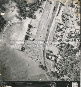 Eltham District Historical Society Inc
Photograph - Aerial Photograph, Main Road and Railway Station area, Hurstbridge, 12 Apr. 1954
Victorian Railways Aerial Surveyshire of eltham archives, aerial photo, main road, anzac avenue, hursbridge, parker road, hurstbridge railway station, rose road -
 Eltham District Historical Society Inc
Photograph - Aerial Photograph, Main Road and Railway Station area, Hurstbridge, 12 Apr. 1954
Victorian Railways Aerial Surveyshire of eltham archives, aerial photo, main road, anzac avenue, hursbridge, parker road, hurstbridge railway station, rose road -
 Dookie Historical Society
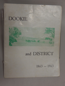
Soft Cover Dookie District History Book - Width 18.5cm x Height 24cm Consist of 33 pages (not numbered), The General Committee Organising the Dookie Back To, Dookie and District 1863 - 1963, Easter 1963 "WATERWHEEL PRESS,"
Soft Cover Historical Book - White Background with 2 green and white soft aerial photographs of prominent landmarks at Dookie. Front Cover - Mount Major on the left and Saddleback on the right. Back Cover - An aerial view of Dookie as it is today, showing the Grain Elevators Board wheat silos under construction (lower right foreground).