Showing 2091 items
matching bendigo maps
-
 Bendigo Historical Society Inc.
Map - STRUGNELL COLLECTION: HUSTLER'S LINE OF REEF, BENDIGO
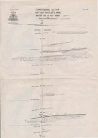
... Inc. History House 11 Mackenzie Street Bendigo goldfields MAP ...Map, Hustler's Line of Reef, Bendigo, Fortuna Hustler's Mine, Longitudinal Section. Plate No. 1V (4). NOTE--- Plates 4,8,13,29,26 & 31 form a Longitudinal Section from Fortuna Hustler's to Hustler's Consols Mine.Bulletin No 33 Signed H.A.Whitelaw. Drawing shows the vertical shaft descending to over 2228 feetUnderground Survey Office, Bendigo.map, bendigo, fortuna hustler's mine -
 Bendigo Historical Society Inc.
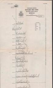
Map - STRUGNELL COLLECTION: HUSTLER'S LINE OF REEFS, September 1913
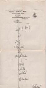
... Inc. History House 11 Mackenzie Street Bendigo goldfields MAP ...Map, Hustler's Line of Reefs, Hustler's Consols Mine, Transverse Section, Bendigo.Plate no. XXX111 (33).Bulletin No 33 Signed H.A.Whitelaw. Drawing shows the vertical shaft descending to over 1326 feet and appears to show samples of connecting horizontal shafts with their respective mineral contentsUnderground Survey Office, Bendigo.map, bendigo, hustler's consols mine -
 Bendigo Historical Society Inc.
Map - HUSTLER'S LINE OF REEFS, September 1913
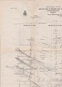
... Inc. History House 11 Mackenzie Street Bendigo goldfields MAP ...Map, Hustler's Line of Reefs, Hustler's Reef & Hustler's Reef No. ! Mines, Bendigo, Longitudinal Section,Plate No.XX (20). NOTE-- Plates 4,8,13,20,26 & 31 form a Logitudinal Section from Fortuna Hustler's to Hustler's Consols Mine.Bulletin No 33 Signed H.A.Whitelaw. Drawing shows the vertical shaft descending to over 1601 feetUnderground Survey Office, Bendigo,map, bendigo, hustler's reef & hustler's reef 1 -
 Bendigo Historical Society Inc.
Map - STRUGNELL COLLECTION: HUSTLER'S LINE OF REEFS, September 1913
... Inc. History House 11 Mackenzie Street Bendigo goldfields MAP ...Map, Hustler's Line of Reefs, Hustler's Reef & Hustler's Reef No1 Mines Plan, Bendigo.Plate No. XV11 (17).Bulletin No 33 Signed H.A.Whitelaw.Underground Survey Office, Bendigo.map, bendigo, hustler's reef & hustler's reef 1 -
 Bendigo Historical Society Inc.
Map - STRUGNELL COLLECTION: HUSTLER'S LINE OF REEFS, September 1913
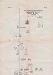
... Inc. History House 11 Mackenzie Street Bendigo goldfields MAP ...Map, Hustler's Line of Reefs, Hustler's Reef Mine, Transverse Section, Bendigo. Plate No. XV111 (18).Bulletin No 33 Signed, H.A.Whitelaw. Drawing shows the vertical shaft descending to over 2195 feet and appears to show samples of connecting horizontal shafts with their respective mineral contentsUnderground Survey Office, Bendigo.map, bendigo, hustler's reef mine -
 Bendigo Historical Society Inc.
Map - STRUGNELL COLLECTION: HUSTLER'S LINE OF REEFS, September 1913
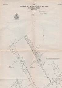
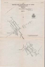
... Inc. History House 11 Mackenzie Street Bendigo goldfields MAP ...Map, Hustler's Line of Reefs, Hustler's Reef & Hustler's Reef No.1 Mines, Plan view . Plate No. XV (15).Sheet 1 Bulletin No. 33. Included is the emblem of the Geological Survey of Victoria. Signed by H.A.Whitelaw Underground Survey Office, Bendigo, Septembe ,1913.Underground Survey Office, Bendigo.map, bendigo, hustler's reef & hustler's reef 1 -
 Bendigo Historical Society Inc.
Map - STRUGNELL COLLECTION: HUSTLER'S LINE OF REEF'S. HUSTLER'S REEF NO.1 MINE, September 1913
... Inc. History House 11 Mackenzie Street Bendigo goldfields MAP ...Map, Hustler's Line of Reefs, Hustler's Reef No. 1, Bendigo, East & West Cross-cuts, North & South of Shaft, Plate No.XX11 (22). Bulletin No 33 Signed H.A.Whitelaw. Drawing shows the vertical shaft descending to over 1229 feet and appears to show samples of connecting horizontal shafts with their respective mineral contentsUnderground Survey Office, Bendigo.map, bendigo, hustler's reef no.1 mine -
 Bendigo Historical Society Inc.
Map - STRUGNELL COLLECTION: HUSTLER'S LINE OF REEFS, September 1913
... Inc. History House 11 Mackenzie Street Bendigo goldfields MAP ...Map, Hustler's Line of Reefs, Hustler's Reef & Hustler's Reef No.1 Mines Plan.Plate No. XV1.(16) Sheet 2 .Bulletin No 33 Signed H.A.Whitelaw.Underground Survey Office, Bendigo, September,1913. Included is the emblem of the Geological Survey of Victoria. Drawing shows a plan view of reefs and shaft locations .Underground Survey Office, Bendigomap, bendigo, hustler's reef & hustler's reef 1 -
 Bendigo Historical Society Inc.
Document - NATIONAL COUNCIL OF WOMEN OF VICTORIA BENDIGO BRANCH COLLECTION: VARIOUS DOCUMENTS
White folder containing a map of the Distribution of EGMs and Venues in City of Greater Bendigo, a News Release 23/2/1995, Third Survey - Community Gambling Patterns 2/2/1996, Victorian Casino and Gaming Authority announces a New Program of Gambling Research 6/6/1996, Release of Research Report-Positive and Negative Perceptions of Gambling 3/9/1996, Media Release 13/9/1996 and a Research Program.organisation, women, national council of women, national council of women of victoria bendigo branch collection, victorian casino and gaming authority, city of greater bendigo -
 Bendigo Historical Society Inc.
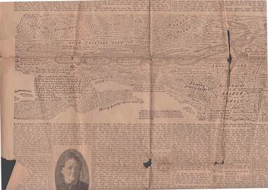
Newspaper - 1911 BENDIGO ADVERTISER, 14th July, 1914
... the Bendigo Advertiser Friday July 14 1911. 1851 discovery of gold... together with an early sketched map of the Bendigo Goldfields ...( x ref 5673 , 8235 , Box 83 , 9077 ) Page 5 and 6 from the Bendigo Advertiser Friday July 14 1911. 1851 discovery of gold significant portion. Part of G Mackay 'Annals of Bendgo'Page 5 has an article titled Annals of Bendigo ''-the first article under this heading was published in the Bendigo Advertiser on 7th July .Included are Cameo photos of Messrs Johnson , Fenton , Sandbach , Frencham and Mrs Kennedy together with an early sketched map of the Bendigo Goldfields . Within the article is a mention of the sketched map as follows - '' The accompanying map was drawn from memory by W. Sandbach who lived a month in the Mia mia (22nd November to 19th December 1851 ) …The map was laid before the Frencham committee at the inquiry. The map shows geographical features such as 'Gentle Rise , Wooded pointbendigo, gold mining, bendigo discovery -
 Bendigo Historical Society Inc.
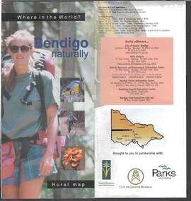
Document - BENDIGO NATURALLY TOURIST BROCHURE
District rural map describing topical walks and activities. Parks Vic, Bendigo Greater City publication.bendigo, tourism, natural environment -
 Bendigo Historical Society Inc.
Book - HENRY MUNDY
Henry Mundy a young Australian pioneer, the memoirs of a man who as a young boy emigrated from Buckinghamshire in 1844 to Australia, he dug for gold in Ballarat, Bendigo ,Clunes and lived through the Eureka stockade plus many more famous Australian historical events which he vividly describes. Hardcover with dustjacket 279 pages with photographs and maps, published by Next Century Books Bedfordshire UK.Les Hughesaustralia, history, pioneers -
 Bendigo Historical Society Inc.
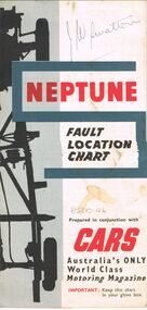
Map - J W SWATTON COLLECTION: MAPS
Seven maps of various sizes. Map of the City of Ballarat, Victoria, Road Condition Map of Victoria including Melbourne-Cairns & Melbourne-Adelaide, Neptune Fault Location Chart, Grampians District Map, Racv Tour Planning Map Showing Road Conditions for Victoria, NSW and Queensland and Mt Macedon & District. Two of the maps have J W swatton & J Swatton written on them.j w swatton collection, racv, mobil, neptune, a r blair, j ewins & sons pty ltd, berry anderson & co -
 Bendigo Historical Society Inc.
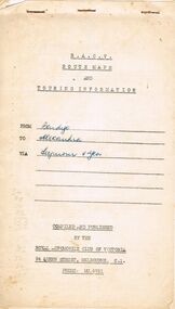
Document - J W SWATTON COLLECTION: RACV ROUTE MAPS
... Four RACV Route Maps and Touring Information, Bendigo... Route Maps and Touring Information, Bendigo to Alexandra via ...Four RACV Route Maps and Touring Information, Bendigo to Alexandra via Seymour and Yea, Bendigo to Mt Gambier and return, Bendigo to Horsham via Ararat and Bendigo to Anglesea, dated 1 March 76. Also an unsigned Safe Driving Pledge.j w swatton collection, royal automobile club of victoria -
 Bendigo Historical Society Inc.
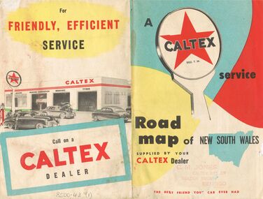
Document - J W SWATTON COLLECTION: MAP OF NEW SOUTH WALES
Two Road maps of New South Wales. C M Jones, Caltex Dealer, Golden Square, Bendigo stamped on the front. Map shows Sydney Outlet Roads, City of Sydney, City of canberra, Newcastle District, Motor tours Around Sydney, Routes to Brisbane, Road Map of New South Wales. It also lists the Principal Towns with Distances from Sydney and Interstate Road Mileages including Sydney to Melbourne via Hume Highway, Prince's Highway, via Canberra & Bombala. Also Sydney to Adelaide via Hume & Sturt Highways, Sydney to Brisbane via New England Highway, Pacific Highway via Toowoomba and Sydney to Adelaide via Western, Mid-Western and Sturt Highways.person, receipts, j w swatton, j w swatton collection, road map of new south wales, caltex, c m jones, e s sculley, clive barrass -
 Bendigo Historical Society Inc.
Slide - DIGGERS & MINING. DIGGERS AND MINERS, c1850s
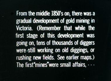
Diggers & Mining. Diggers and miners. From the middle 1850's on, there was a gradual development of gold mining in Victoria. (Remember that while the first stage of this, development was going on, tens of thousands of diggers were still working on old diggings, or rushing new fields. See earlier maps.) The first ''mines'' were small affairs, - - - Markings: 25 994:LIF I. Used as a teaching aid.hanimounteducation, tertiary, goldfields -
 Bendigo Historical Society Inc.
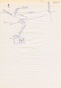
Document - DWYER COLLECTION: DRAWINGS MAPS AND PHOTOGRAPHS OF STONE WELL MAIDEN GULLY
... BENDIGO Buildings stone well map Map on lined writing paper ...Map on lined writing paper, showing location of stone well in Maiden Gully, on Biffins Track, off Edward Rd., Maiden Gully.bendigo, buildings, stone well map -
 Bendigo Historical Society Inc.
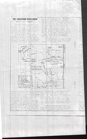
Document - PHOTOCOPIED ARTICLE OF 'THE SEBASTIAN GOLD-RUSH PART 1 & 2 . BY F. ROBBINS'
Photocopied articles of 'The Sebastian Gold-Rush parts 1 & 2 . By F. Robbins' .First page shows a map of the goldfield.F. Robbins'document, gold, the sebastian gold-rush -
Bendigo Historical Society Inc.
Map - HEATHCOTE : COUNTY OF BENDIGO, 19-2-1942
... Map. Heathcote, County of Bendigo. County of Dalhousie... Inc. History House 11 Mackenzie Street Bendigo goldfields MAP ...Map. Heathcote, County of Bendigo. County of Dalhousie, McIvor Creek,Wallan and Bendigo Railway, By authority H.E. Daw, Government Printer, Melbourne. Drawn and reproduced at the Department of Lands and Survey, Melbourne. 19-2-1942. Price 2/-. (number 90 in map cupboard 1)H.E. Daw, Government Printer, Melbourne.map, bendigo, heathcote -
Bendigo Historical Society Inc.
Map - HEATHCOTE : COUNTY OF BENDIGO, May 1952
... Map. Heathcote, County of Bendigo, County of Housie... Inc. History House 11 Mackenzie Street Bendigo goldfields MAP ...Map. Heathcote, County of Bendigo, County of Housie, Knowsley, Knowsley East, Langwornor, Tooborac, Warrowitue, Costerfield, Dargile, Township of Heathcote, Meadows Valley Creek, Wallan and Bendigo Railway, C.R.B. Main Road. By authority J.J. Gourley, Government Printer, Melbourne, Drawn and reproduced at the Department of Lands and Survey, Melbourne. May 1952, Price 2/-. (number 89 in map cupboard 1)J.J. Gourley, Government Printer, Melbourne.map, bendigo, heathcote -
Bendigo Historical Society Inc.
Map - HEATHCOTE : COUNTY OF BENDIGO, 11-4-35
... Map. Heathcote, County of Bendigo, County of Dalhousie... Inc. History House 11 Mackenzie Street Bendigo goldfields MAP ...Map. Heathcote, County of Bendigo, County of Dalhousie,Township of Heathcote, McIvor Creek, Argyle Station Ground, Wallan and Bendigo Railway, C.R.B. Main Road. By authority H.J. Green, Govt. Printer. Photo-Lithographed at the Department of Lands and Survey, Melbourne. 11-4-35. Price 2/-. (number 88 in map cupboard 1)H.J. Green, Govt.Printermap, bendigo, heathcote -
Bendigo Historical Society Inc.
Map - RAVENSWOOD, COUNTIES OF BENDIGO & TALBOT, 12-12-22
... Map, Ravenswood, Counties of Bendigo & Talbot, Shelbourne... Inc. History House 11 Mackenzie Street Bendigo goldfields MAP ...Map, Ravenswood, Counties of Bendigo & Talbot, Shelbourne, Walmer, Harcourt, Sutton Grange, Mandurang, Lockwood.By Authority A.J.Mullett, Govt. Printer, Melbourne. Photo-Lithographed at the Dept. of Lands and Survey, Melbourne by W.J.Butson 12-12-22, Price1/-. (number 87 in map cupboard 1)A.J.Mullett. Govt. Printer, Melbourne.map, bendigo, ravenswood -
Bendigo Historical Society Inc.
Map - RAVENSWOOD : COUNTY OF BENDIGO, 28-7-14
... Map. Ravenswood, County of Bendigo, County of Talbot... Inc. History House 11 Mackenzie Street Bendigo goldfields MAP ...Map. Ravenswood, County of Bendigo, County of Talbot, Lockwood, Sutton Grange, Harcourt, Walmer, Bradford, Shelbourne, Mandurang, Photo-Lithographed at the Department of Lands and Survey by T.F. McGauran 28-7-14. (number 86 in map cupboard 1)T.F. McGauranmap, bendigo, ravenswood -
Bendigo Historical Society Inc.
Map - POMPAPIEL : COUNTY OF BENDIGO, 1-10-27
... Map. Pompapiel, County of Bendigo, Calivil, Talambe... Inc. History House 11 Mackenzie Street Bendigo goldfields MAP ...Map. Pompapiel, County of Bendigo, Calivil, Talambe, Yallook, Salisbury, Yarrayne, Janiember East, Waranga Mallee Channel, Blind Creek, Judyong Creek, Bullock Creek. Photo-Lithographed at the Dept. of Lands and Survey Melbourne by W.J. Butson 1-10-27. Price 1/-. (number 85 in map cupboard 1)W.J. Butsonmap, bendigo, pompapiel -
Bendigo Historical Society Inc.
Map - POMPAPIEL : COUNTY OF BENDIGO, 1-10-27
... Map. Pompapiel, County of Bendigo, Calivil, Talambe... Inc. History House 11 Mackenzie Street Bendigo goldfields MAP ...Map. Pompapiel, County of Bendigo, Calivil, Talambe, Yallook, Salisbury, Yarrayne, Janiember East, Waranga Mallee Channel, Judyong Creek.Pompapiel Creek, Bullock Creek, Blind Creek. Photo-Lithographed at the Department of Lands and Survey by W.J. Butson, 1-10-27. Price 1/-. (number 84 in map cupboard 1)W.J. Butson.map, bendigo, pompapiel -
Bendigo Historical Society Inc.
Map - PANNOOMILLOO : COUNTY OF BENDIGO, 1957
... Map. Pannoomilloo, County of Bendigo, Pannoobamawm, Milloo... Inc. History House 11 Mackenzie Street Bendigo goldfields MAP ...Map. Pannoomilloo, County of Bendigo, Pannoobamawm, Milloo, Diggorra, Warragamba. Elmore Cohuna Railway. Waranga Mallee Channel. By authority W.M. Houston, Government Printer, Melbourne. Drawn and reproduced at the Department of Lands and Survey, Melbourne 1957. Price 2/-. (number 83 in map cupboard 1)W.M. Houston, Government Printer, Melbourne.map, bendigo, pannoomilloo -
Bendigo Historical Society Inc.
Map - PANNOOMILLOO : COUNTY OF BENDIGO, 17-12-13
... Map. Pannoomilloo, County of Bendigo, Pannoobamawm... Inc. History House 11 Mackenzie Street Bendigo goldfields MAP ...Map. Pannoomilloo, County of Bendigo, Pannoobamawm, Warragamba, Milloo, Diggorra. Photo-Lithographed at the Department of Lands and Survey, Melbourne by W.J. Butson 17-12-13, Price 1/-. (number 82 in map cupboard 1)W.J. Butson.map, bendigo, pannoomilloo -
Bendigo Historical Society Inc.
Map - PANNOOBAMAWM : COUNTY OF BENDIGO, 7-9-15
... Map. Pannoobamawm, County of Bendigo, Terrick Terrick East... Inc. History House 11 Mackenzie Street Bendigo goldfields MAP ...Map. Pannoobamawm, County of Bendigo, Terrick Terrick East, Wanurp, Pannoomilloo, Bamawm,Turrumberry. By authority Albert J. Mullett, Government Printer, Melbourne. Photographed at the Deptartment of Lands and Survey, Melbourne. By W.J. Butson 7-9-15. Price 1/-. (number 81 in map cupboard 1)W.J. Butson, Government Printer, Melbourne.map, bendigo, pannoobamawm -
Bendigo Historical Society Inc.
Map - PANNOOBAMAWM : COUNTY OF BENDIGO, 1957
... Map. Pannoobamawm, County of Bendigo, Turrumberry, Terrick... Inc. History House 11 Mackenzie Street Bendigo goldfields MAP ...Map. Pannoobamawm, County of Bendigo, Turrumberry, Terrick Terrick East, Wanurp, Pannoomilloo, Bamawm, Elmore to Cohuna Railway, McColl Station Ground, Lockington Station Ground. By authority W.M. Houston, Government Printer, Melbourne. Drawn and reproduced at the Department of Lands and Survey, Melbourne 1957. Price 2/-. (number 80 in map cupboard 1)W.M. Houston, Government Printer, Melbourne.map, bendigo, pannoobamawm -
Bendigo Historical Society Inc.
Map - NOLAN : COUNTY OF BENDIGO, 22-7-13
... Map. Nolan, County of Bendigo, Egerton, Elmore, Goornong... Inc. History House 11 Mackenzie Street Bendigo goldfields MAP ...Map. Nolan, County of Bendigo, Egerton, Elmore, Goornong, Northern Railway, Campaspe River. By authority A.J.Mullett, Government Printer, Melbourne. Photo-Lithographed at the Deptartment of Lands and Survey, Melbourne by W.J. Butson 22-7-13. Price 1/-. (number 79 in map cupboard 1)A.J. Mullett, Government Printer, Melbourne.map, bendigo, nolan