Showing 8606 items matching "bridge-spike"
-
 Eltham District Historical Society Inc
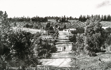
Photograph, Tom Prior, Research Gully Bridge, Research Gully Road, Research, c.1895
Research Gully Bridge. At time of collection (1970) Ingrams Road was formerly Research Gully Road. The Maroondah Aqueduct runs along the base of the pine trees.The Reynolds family were early settlers in Research. The Reynolds/ Prior collection of photographs were taken by Tom Prior, the maternal uncle of Ivy Reynolds, around 1900 and the 60 photos in the album give a fine overview of many of the landmarks of Research and Eltham over 100 years ago. lvy lived in the family home for many years at 106 Thompson Cres Research. Ivy's father, Ernst Richard Reynolds and grandfather, Richard Reynolds, lived at the same address. Ivy's father Richard worked for Mr. Trail on his property in Research. Reynolds Road is named after the family. Mr Tom Prior (wife Eva) worked at the Melbourne zoo. He was very innovative and made his own camera, using the black cloth hood to exclude the light. The photographs are a reminder of the rural nature of Research and Eltham and its rich heritage. Black and white photograph mounted in an album, the Reynolds/Prior Photograph Collection, this being one of 53 reproduced black and white images of early Eltham. (Duplicated on p38 also)The Reynolds/Prior Photograph Collection, Presented to the Eltham District Historical Society, 14 June 2006 by Ross McDonald. A second copy was also presented to the Andrew Ross Museum, Kangaroo Groundaqueduct, ingrams road, research (vic.), research gully bridge, research gully road, reynolds prior collection, shire of eltham pioneers photograph collection, bridge -
 Eltham District Historical Society Inc
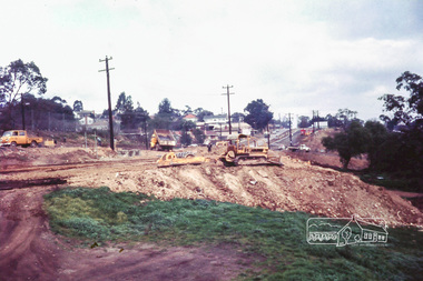
Photograph, Russell Yeoman, Main Road duplication roadworks between Bridge Street and Shire of Eltham offices, 1968, 1968
Viewed from the southern end of the Eltham Shire Office, Panther Place in centre distance and Bridge Street in distance running down from Main RoadDigital file only; created from original colour positive slide transparencystreets, main road, eltham shire office, bridge street, duplication, panther place, road construction, road widening, russell yeoman collection -
 City of Ballarat Libraries
Photograph - Card Box Photographs, Rail Bridge over Market Street, Ballarat 1959
This bridge carried pigs to a rail siding in Doveton Street North on the site of the former Civic Hall car park. It was demolished when the Civic Hall was built.rail bridge, market street, civic hall, streetscape, transportation, commerical -
 Charlton Golden Grains Museum Inc
Photograph, Brownjohn, Reg, Rear of Johnson's Bridge Store c. 2000, c.2000
Derelict rear of building built as Bridge Store in 1872 for Peter Johnson, later Wylie's Building and a furniture store. Photo taken for the Museum by R. Brownjohn.Colour photograph of the rear of an old, brick two storey building. Building appears derelict and disused. Part of the roof is missing on the lower section and the beams are exposed. Verandah is sagging. Gas tank/hot water service in corner in the centre of the photo. Single door to the right of the gas tank and double doors to the left. One large and one small window in the upstairs section. Chimney on LH side of upper storey.bridge store, peter johnson, wylie's building, charlton, business -
 Ringwood and District Historical Society
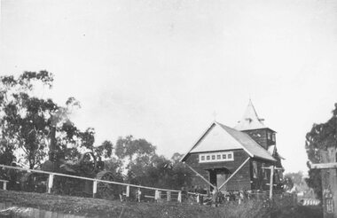
Photograph, Ringwood Church of England stuck on Warrandyte Rd. bridge over Mullum Creek whilst being removed - 1924
Black and white photograph of building, steam-roller in front.Written on backing sheet, "C of E stuck on W'dyte Rd. bridge over Mullum Ck. whilst being taken from C.r Main & Pratt Sts. to new site in Ringwood St. 1924" -
 Ringwood and District Historical Society
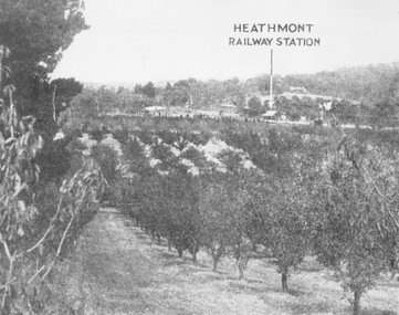
Photograph, View of what was Heathmont township taken from about Royal Avenue looking at Mr. Herman Pump's orchard. Old bridge over Canterbury Road can be seen on left
Typed below photograph, "View of what was Heathmont township taken from about Royal Avenue looking at Mr. Herman Pump's orchard. Old bridge over Canterbury Road can be seen on left." -
 Ringwood and District Historical Society
Photograph, Looking to Adelaide St. from Reynolds Ave. Ringwood (across Mullum Creek) 1973. Site of bridge washed away in floods 1931. Infant Welfare Centre (Dr. Hewitts) on right
Black and white photographCatalogue card reads, "Looking to Adelaide St. from Reynolds Ave. (across Mullum Creek) 1973. Site of bridge washed away in floods 1931. Infant Welfare Centre (Dr. Hewitts) on right." -
 National Vietnam Veterans Museum (NVVM)
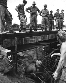
Photograph, Gibbons, Denis, Bridge Inspection
Denis Gibbons (1937 – 2011) Trained with the Australian Army, before travelling to Vietnam in January 1966, Denis stayed with the 1st Australian Task Force in Nui Dat working as a photographer. For almost five years Gibbons toured with nine Australian infantry battalions, posting compelling war images from within many combat zones before being flown out in late November 1970 after sustaining injuries. The images held within the National Vietnam Veterans Museum make up the Gibbons Collection. A black and white photograph of the 1st Australian Task Force Commander (Aug 1969 - Jun 1970) Brigadier Stewart Weir MC, inspects a bridge built by 17 Construction Squadron over a creek northwest of the province capital Baria. The Engineers are fitting screens to protect the foundations.photograph, brig stewart weir, 1st atf base, baria, gibbons collection catalogue, 17th construction squadron, engineers, military cross, 1st australian task force, denis gibbons -
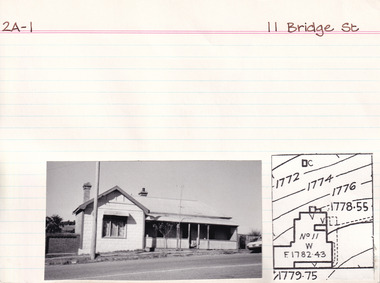 The Beechworth Burke Museum Research Collection
Card (Series) - Index Card, George Tibbits, 11 Bridge Street, Beechworth, 1976
George Tibbits, University of Melbourne. Faculty of Architecture, Building and Town & Regional PlanningIndex system that support the research for Beechworth : historical reconstruction / [by] George Tibbits ... [et al]Arranged by street names of BeechworthEach index card includes: street name and number of property, image of property, allotment and section number, property owners and dates of ownership, description of the property according to rate records, property floor plan with dimensions.beechworth, george tibbitsbeechworth, george tibbits -
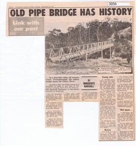 Greensborough Historical Society
Newspaper Clipping, Diamond Valley News, Old pipe bridge has history, by Marguerite Marshall, 1891o
The aqueduct siphon bridge over the Plenty River, opened in 1891, was part of the pipeline bringing water from the service reservoir at Healesville, prior to the construction of the Maroondah Reservoir.News article, black and white text and photograph.aqueduct pipe bridge greensborough -
 The Beechworth Burke Museum Research Collection
Card (Series) - Index Card, George Tibbits, Bridge Street, Beechworth, 1976
George Tibbits, University of Melbourne. Faculty of Architecture, Building and Town & Regional PlanningIndex system that support the research for Beechworth : historical reconstruction / [by] George Tibbits ... [et al]Arranged by street names of BeechworthEach index card includes: street name and number of property, image of property, allotment and section number, property owners and dates of ownership, description of the property according to rate records, property floor plan with dimensions.beechworth, george tibbitsbeechworth, george tibbits -
 Bendigo Military Museum
Photograph - PHOTOGRAPH, TAMARAN BRIDGE, British Air Force, C1943-1945
Refer Cat no. 5445.2Photo shows flat, uninhibited land. A river (low tide) snakes through the photo. In the centre is a trestle bridge crossing the river. A bomb ( water and smoke) blast is rising from the side of bridge Photograph rear in ink. “Tamaram bridge" being bombed. Bridge built by POWS. The span was never rebuilt. Trains stopping both sides and goods carried along foot of bridge, on a narrow bridge by POWs.ww2, pow, tamaran bridge, burma railway -
![Scene on the Yarra, near Rourke's Bridge / [by] Nicholas Caire, circa 1876](/media/collectors/550653872162f11fb04854aa/items/5777571cd0cdd10a5c191a9c/item-media/57775788d0cdd10a5c193e0d/item-fit-380x285.jpg) Kew Historical Society Inc
Kew Historical Society IncPhotograph, Anglo-Australasian Photographic Company, Scene on the Yarra, near Rourke's Bridge, c. 1876
Nicholas Caire was born on Guernsey in the Channel Islands in 1837. He arrived in Adelaide with his parents in about 1860. In 1867, following photographic journeys in Gippsland, he opened a studio in Adelaide. From 1870 to 1876 he lived and worked in Talbot in Central Victoria. In 1876 he purchased T. F. Chuck's studios in the Royal Arcade Melbourne. In 1885, following the introduction of dry plate photography, he began a series of landscape series, which were commercially successful. As a photographer, he travelled extensively through Victoria, photographing places few of his contemporaries had previously seen. He died in 1918. Reference: Jack Cato, 'Caire, Nicholas John (1837–1918)', Australian Dictionary of BiographyAn original, rare photograph from the series 'Views of Victoria: General Series' by the photographer, Nicholas Caire (1837-1918). The series of 60 photographs that comprise the series was issued c. 1876 and reinforced a neo-Romantic view of the Australian landscape to which a growing nationalist movement would respond. Nicholas Caire was active as a photographer in Australia from 1858 until his death in 1918. His vision of the Australian bush and pioneer life had a counterpart in the works of Henry Lawson and other nationalist poets, authors and painters.Albumen silver photograph mounted on boardprinted in ink on support l.c.: SCENE ON THE YARRA, NEAR ROURKE'S BRIDGE. / COPYRIGHT REGISTERED. printed in ink on support reverse c.: VIEWS OF VICTORIA. / (GENERAL SERIES.) / No. 16. / SCENE ON THE YARRA, NEAR ROURKE'S BRIDGE. / The subject of the present illustration represents the New Bridge crossing the River Yarra on the road from / St. Huberts to the Native Station at Corranderrk, and to the township at Healesville. The river at this place abounds / with fish of a large description, which are caught by the Natives, frequently in considerable quantitities. printed in ink on support reverse l.c.l.: J.W. FORBES, Agent, printed in ink on support reverse l.c.: ANGLO-AUSTRALASIAN PHOTOGRAPHIC COMPANY, MELBOURNE. printed in ink on support reverse l.c.r.: 10 Temple Court, Collins Street West.nicholas caire (1837-1918), landscape photography - victoria -
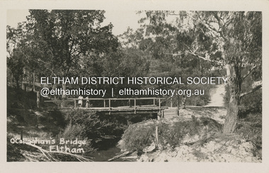 Eltham District Historical Society Inc
Postcard - Photograph postcard, O'Callaghan's Bridge, Eltham, c.1925
Based on the women's hat styles, estimated date is circa 1925. This is a replacement of an earlier lower level bridge which had an secondary high level footbridge added in 1917Digital file only Postcards scanned from the collection of Michael Aitken on loan to EDHS, 2 Sep. 2022michael aitken collection, eltham, postcards, diamond creek (creek), diamond street, diamond street bridge, o'callaghan's bridge -
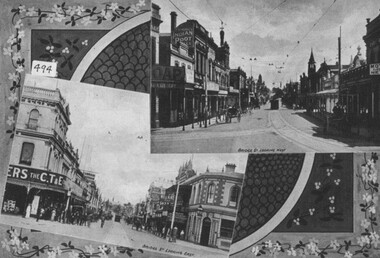 City of Ballarat Libraries
Photograph - Card Box Photographs, Views looking east and west along Bridge Street, Ballarat c1915
East and west views along Bridge Street. Buildings along the streets include Cowdell Tonner & Ellis and the Bucks Head Hotel. This comes from the Ballarat Homecoming publication.bridge street, ballarat, streetscape, buildings, cowdell tonner & ellis, bucks head hotel, public, commerical, hotel, ballarat homecoming -
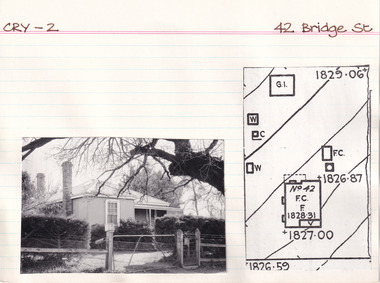 The Beechworth Burke Museum Research Collection
Card (Series) - Index Card, George Tibbits, 42 Bridge Street, Beechworth, 1976
George Tibbits, University of Melbourne. Faculty of Architecture, Building and Town & Regional PlanningIndex system that support the research for Beechworth : historical reconstruction / [by] George Tibbits ... [et al]Arranged by street names of BeechworthEach index card includes: street name and number of property, image of property, allotment and section number, property owners and dates of ownership, description of the property according to rate records, property floor plan with dimensions.beechworth, george tibbitsbeechworth, george tibbits -
 The Beechworth Burke Museum Research Collection
Card (Series) - Index Card, George Tibbits, 44 Bridge Street, Beechworth, 1976
George Tibbits, University of Melbourne. Faculty of Architecture, Building and Town & Regional PlanningIndex system that support the research for Beechworth : historical reconstruction / [by] George Tibbits ... [et al]Arranged by street names of BeechworthEach index card includes: street name and number of property, image of property, allotment and section number, property owners and dates of ownership, description of the property according to rate records, property floor plan with dimensions.beechworth, george tibbitsbeechworth, george tibbits -
 The Beechworth Burke Museum Research Collection
Card (Series) - Index Card, George Tibbits, 44A Bridge Street, Beechworth, 1976
George Tibbits, University of Melbourne. Faculty of Architecture, Building and Town & Regional PlanningIndex system that support the research for Beechworth : historical reconstruction / [by] George Tibbits ... [et al]Arranged by street names of BeechworthEach index card includes: street name and number of property, image of property, allotment and section number, property owners and dates of ownership, description of the property according to rate records, property floor plan with dimensions.beechworth, george tibbitsbeechworth, george tibbits -
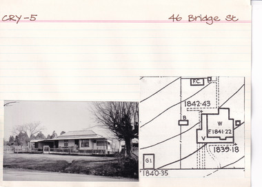 The Beechworth Burke Museum Research Collection
Card (Series) - Index Card, George Tibbits, 46 Bridge Street, Beechworth, 1976
George Tibbits, University of Melbourne. Faculty of Architecture, Building and Town & Regional PlanningIndex system that support the research for Beechworth : historical reconstruction / [by] George Tibbits ... [et al]Arranged by street names of BeechworthEach index card includes: street name and number of property, image of property, allotment and section number, property owners and dates of ownership, description of the property according to rate records, property floor plan with dimensions.beechworth, george tibbitsbeechworth, george tibbits -
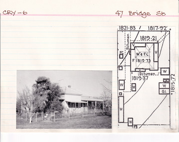 The Beechworth Burke Museum Research Collection
Card (Series) - Index Card, George Tibbits, 47 Bridge Street, Beechworth, 1976
George Tibbits, University of Melbourne. Faculty of Architecture, Building and Town & Regional PlanningIndex system that support the research for Beechworth : historical reconstruction / [by] George Tibbits ... [et al]Arranged by street names of BeechworthEach index card includes: street name and number of property, image of property, allotment and section number, property owners and dates of ownership, description of the property according to rate records, property floor plan with dimensions.beechworth, george tibbitsbeechworth, george tibbits -
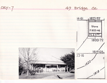 The Beechworth Burke Museum Research Collection
Card (Series) - Index Card, George Tibbits, 49 Bridge Street, Beechworth, 1976
George Tibbits, University of Melbourne. Faculty of Architecture, Building and Town & Regional PlanningIndex system that support the research for Beechworth : historical reconstruction / [by] George Tibbits ... [et al]Arranged by street names of BeechworthEach index card includes: street name and number of property, image of property, allotment and section number, property owners and dates of ownership, description of the property according to rate records, property floor plan with dimensions.beechworth, george tibbitsbeechworth, george tibbits -
 Greensborough Historical Society
Notes, Lower Plenty Bridge notes by Russell Yeoman, 18/10/1887o
Notes on the history of Lower Plenty by Russell Yeoman, Eltham Historical Society; including references to Andrew Ross from his "Reminiscences" and an article from Trove on the Lower Plenty Bridge. 3 typed pages.lower plenty, russell yeoman, andrew ross -
 Eltham District Historical Society Inc
Photograph, Hurstbridge - Construction of new bridge
In early November 1917 the new reinforced concrete bridge across the Diamond Creek at Hurstbridge was officially opened with "some 500 spectators", some who had arrived by train for the occassion.This photo forms part of a collection of photographs gathered by the Shire of Eltham for their centenary project book, "Pioneers and Painters: 100 years of the Shire of Eltham" by Alan Marshall (1971). The collection of over 500 images is held in partnership between Eltham District Historical Society and Yarra Plenty Regional Library (Eltham Library) and is now formally known as 'The Shire of Eltham Pioneers Photograph Collection.' It is significant in being the first community sourced collection representing the places and people of the Shire's first one hundred years.Digital imagesepp, shire of eltham pioneers photograph collection, hurstbridge, bridge, bridge construction -
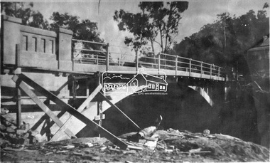
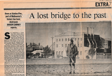 Port Melbourne Historical & Preservation Society
Newspaper, Shaun CARNEY, A Lost Bridge to the Past, 17 Aug 1991
Shaun CARNEY's article on the demolition of Centenary Bridge includes reminiscences of Jim BREN. He also mentions the closure of the Swallow & Ariell Ltd Steam Biscuit Manufactory earlier in 1991.Part of page 7 from The Age Extra 17 Aug 1991.piers and wharves - station pier, shaun carney, swallow & ariell ltd, jim bren, centenary bridge, built environment - demolition -
 Glenelg Shire Council Cultural Collection
Photograph, 1950-1960
Sourced from Casterton Town Hall former Shire of GlenelgBlack and white photo. Two bridges, side by side. One on left is part of unsealed road, the one on right is a wooden bridge. Kings Bridge Merino-Coleraine Rd.Front: 'Kings Bridge Merino-Coleraine Rd. Traffic detoured over temporary Bridge on Right' - handwritten, pen Back: Photographer's stamp - round, purple -
 Linton and District Historical Society Inc
Photograph, Early Pitfield, Showing Bridge, Store and Hotel
Identified by inscription on the back of the photograph as "Early Pitfield", and the buildings as "Matthew Hamilton Baird's . . . hotel & store". Information from Joan Hunt (see 'Pitfield/Kaleno' file) says the Emu Inn or Pitfield Hotel was at Pitfield/Wardy Yallock township on the road from Skipton to Geelong. Part of this area - foreground, to the left, was called "Buncle's Flat", named after John Buncle, a carpenter who lived in a cottage there with his family. An early timber inn on the Wardy Yallock Creek was owned first by Peter Hardie and then by Edward Langhorne/John McNamara in the 1840s and a mail run from Geelong was established to it in 1846. Matthew Hamilton Baird was the lessee or owner from 1852, and Benjamin Fernald from about 1860. In 1853, the nearby store, at that time owned by William Whitecross, caught fire. The fire spread to the hotel and both buildings were destroyed. The hotel was replaced by the brick or stone building seen in the photograph.Small black and white copy of original photograph which shows trees, fencing and farm buildings in foreground, and in the background a large stone or brick building plus smaller timber buildings (dwellings?) situated along a roadway. On the right of the photograph the road goes over a large bridge of timber construction.On back of photograph: "Early Pitfield showing Matthew Hamilton Baird's store (stone?) & hotel & store".pitfield bridge, pitfield hotel, pitfield township, buncle's flat, emu inn, buildings, hotels, matthew hamilton baird, benjamin fernald, edward langhorne, john mcnamara, william whitecross -
 The Beechworth Burke Museum Research Collection
Card (Series) - Index Card, George Tibbits, 14 Bridge Street, Beechworth, 1976
George Tibbits, University of Melbourne. Faculty of Architecture, Building and Town & Regional PlanningIndex system that support the research for Beechworth : historical reconstruction / [by] George Tibbits ... [et al]Arranged by street names of BeechworthEach index card includes: street name and number of property, image of property, allotment and section number, property owners and dates of ownership, description of the property according to rate records, property floor plan with dimensions.beechworth, george tibbitsbeechworth, george tibbits -
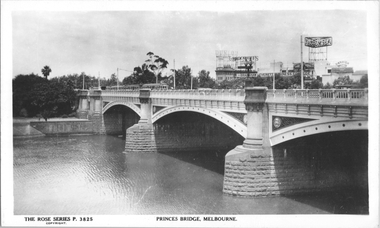 Melbourne Tram Museum
Postcard, Rose Stereograph Co, Princes Bridge Melbourne", mid to late 1930s
Rose Series postcard No. P 3825, titled Princes Bridge Melbourne", showing at least four trams, including some W2 class cars on the bridge. The YMCA building with the "Dunlop Weftless Cord Tyre" sign on top. The "Aspro" sign on top of the Aspro Buildings in City Road. The "Garrick Theatre" sign on the roof of the theater in Aikman Street plus, advertisements for: "Brockhoff Biscuits", "Berger Paints" and "Bradshaw & Everett Business College". The photo is taken from Batman Avenue tram terminus looking southwest.Yields information about Princes Bridge, in the middle to late 1930sPostcard - printed real photograph with Rose Stereograph Co. name on the rear.trams, princes bridge, st kilda road, tramways, advertisements, w2 class, yarra river -
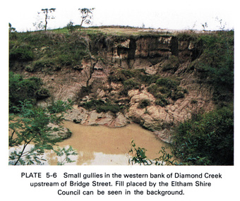 Eltham District Historical Society Inc
Work on paper (Sub-Item) - Photograph, Small gullies in the western bank of Diamond Creek upstream of Bridge Street, Eltham
Colour photograph of a muddy creek (probably after a downpour) on the western bank of Diamond Creek upstream of Bridge Street, Eltham. Fill placed by the Eltham Shire Council can be seen in the backgroundeltham, diamond creek, bridge street, gullies, fill -
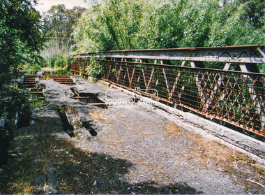 Eltham District Historical Society Inc
Photograph, Doug Orford, Lower Plenty Bridge, Old Eltham Road, Lower Plenty, 1998
Originally the boundary between the former Shire of Eltham and the City of Heidelberg, a toll gate existed on the Eltham side. The bridge has since been restored and is now part of the Plenty River Trail.Two colour photograph prints 10 x 15 cm (2 copies)bridges, lower plenty, main road, plenty river, old eltham road