Showing 23147 items matching "creeks"
-
 Falls Creek Historical Society
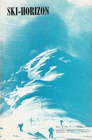
Journal - Ski-Horizon Vol 4 No 7
Ski-Horizon is the official journal of the Federation of Victorian Ski Clubs which began publication in 1949. The were 26 original member clubs which included Albury Ski Club, Bogong Ski Club, Myrtleford Ski Club, Tallangatta and District Ski Club and Wangaratta Ski Club. Two pioneers of Falls Creek, Tom Mitchell, M.L.A., and Martin Romuld were Vice-Presidents of the Federation.This Journal is significant because it documents the early development of skiing in Victoria.The journal features stories and events chronicling developments in Victoria and internationally. Items related to the Falls Creek Area in this issue include:- Page 2:- Tonl St. Elmo (Nissen Alpine Club) had been appointed as a Justice of the Peace. Climatologists with the CSIRO reported that the mean daily temperature of summer in Victoria and NSW had fallen by 3°F since 1880 whilst in the Northern Hemisphere summers were becoming warmer. Page 5: There was to be no Queen's Birthday holiday this year but Tuesday 2nd June would be a public holiday for Coronation Day. Page 11: Featured "They're Busy in the North-East" - nothing has been heard of the Sydney Clubs which had proposed building at Falls Creek and Beechworth seems to be in danger of losing its site. Nissen Alpine Club has had plans for extension approved. A new rope was being installed for the Nissen tow. Falls Creek was undoubtedly the most progressive centre in the North East. For a slightly rougher experience Cleve Cole Memorial Lodge was recommended.tom mitchell m.l.a., toonallook, fred griffith -
 Falls Creek Historical Society
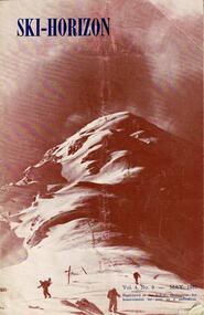
Journal - Ski-Horizon Vol 4 No 9
Ski-Horizon is the official journal of the Federation of Victorian Ski Clubs which began publication in 1949. The were 26 original member clubs which included Albury Ski Club, Bogong Ski Club, Myrtleford Ski Club, Tallangatta and District Ski Club and Wangaratta Ski Club. Two pioneers of Falls Creek, Tom Mitchell, M.L.A., and Martin Romuld were Vice-Presidents of the Federation.This Journal is significant because it documents the early development of skiing in Victoria.The journal features stories and events chronicling developments in Victoria and internationally. Items related to the Falls Creek Area in this issue include:- Page 1:- Dawn Ski Club is formed by families with the aim of facilitating skiing for children. After the April meeting it took Dawn Daddies some time to round up many juniors aged from 2½ to 7½ years old. Page 3 - Fred Griffith was elected President of the Albury Ski Club; Toni and Skippy St. Elmo would be running a cafe at the Nissen Club's Tow House and would also be selling some groceries. Full postal services may also be available; Falls Creek was looking to have a successful season with Bob Hymans providing first class accommodation and instruction, the Bogong Ski Club offering accommodation to other clubs and the Nissen Ski Tow considerable improved and operating again. Page 23 - Arrangements which had been made by the SEC for access to Falls Creek were also clearly outlined. bogong ski club, toni st. elmo, skippy st. elmo, fred griffith, bob hymans, nissen ski tow -
 Falls Creek Historical Society
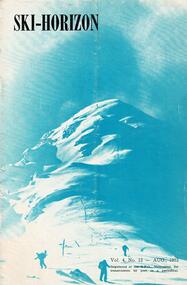
Journal - Ski-Horizon Vol 4 No 12
Ski-Horizon is the official journal of the Federation of Victorian Ski Clubs which began publication in 1949. The were 26 original member clubs which included Albury Ski Club, Bogong Ski Club, Myrtleford Ski Club, Tallangatta and District Ski Club and Wangaratta Ski Club. Two pioneers of Falls Creek, Tom Mitchell, M.L.A., and Martin Romuld were Vice-Presidents of the Federation.This Journal is significant because it documents the early development of skiing in Victoria.The journal features stories and events chronicling developments in Victoria and internationally. Items related to the Falls Creek Area in this issue include:- Page 11:- Busy year for Falls Creek Instructors. Bob Hymans has been a great asset for the last three seasons. Milan Kovicic (previously instructing in Italy for 11 years) and Toni St. Elmo are instructing at the Nissen Ski School Page 13 - Toni & Skippy St. Elmo's Tow House canteen sells every provision a skier could ever want - hot meals, groceries, toilet and first-aid gear, stationery - even souvenirs. Page 20 - Falls Creek in Spring - Bogong Ski Club reports improvements in their facilities as well as around Falls Creek. Their lodge has been repainted and refurnische. The SEC has begun to allow private car convoys to travel to Howman's at set times. Regular trains are available from Melbourne connect with Hoy's Bus at Wangaratta. Overnight accommodation and parking can be arranged at Tawonga. The Tow House now provides two tows and food supplies. Snow conditions were lending themselves to a bumper year ahead. Members of other clubs could apply to stay at Bogong Ski Club at an overnight fee of 10/- for Melbourne clubs amd 8/- for N.E.D.S.A. Clubs plus 6d. per night for the Skiing Improvement Fund.tom mitchell m.l.a., bogong ski club, toni st. elmo -
 Falls Creek Historical Society
Document - Meeting Minutes Of Falls Creek Alpine Village Advisory Committee
Bob Hymans Collection Bob (Herman) Hymans (a former member of the Royal Netherlands Navy was born in Bloemendaal, Holland on 30th September 1922. During World War II he fought against the Japanese in the Dutch East Indies (now Indonesia) and was imprisoned in Changi and on the Burma Railway. After gaining qualifications as a Ski Instructor, Bob arrived in Falls Creek in May 1950. Working as an Instructor and Supervisor at Bogong Lodge, Bob decided his future was in accommodation. He was successful in negotiating an indenture for land from the State Electricity Commission (SEC). It took Bob two years to build his Grande Coeur Chalet but, tragically, it was burned down in August 1961. Bob also built the first Chairlift in Australia. This was a single chairlift and the structure was built from wooden electricity poles. He was constantly full of new ideas and proposals for the village. Bob Hymans died on 7th July 2007. This Collection of documents and letters tells the story of Bob’s endeavours to develop Falls Creek into the ski village it is today.This document is significant because it documents discussion concerning the operation of Falls Creek.MInutes of the Falls Creek Alpine Village Advisory Committee held on 21 September 1957 typed on foolscap size paper. Topics of discussion included contributions to the Ski Improvement Fund, equipment in the Casualty Room and also the possibility of erecting a simple rope tow on the nursery slope.chairlift falls creek, bob hymans, ski improvement fund, falls creek alpine village advisory committee -
 Bendigo Historical Society Inc.
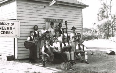
Photograph - PETER ELLIS COLLECTION: EMU CREEK BUSH BAND
Black and white photo of the Emu Creek Bush band outside a small weatherboard building with Emu Creek sign over the door. To the left of the door is a sign with large black printing. It reads: In Memory of the Pioneers of Emu Creek. The band members are sitting or standing with their musical instruments. A heeler dog is sitting on the ground in front of them.photo, group, emu creek bush band, peter ellis collection, emu creek bush band -
 Lakes Entrance Historical Society
Photograph - Tramline, 1930c
Tramline used to transport red granite from the quarry at Mississippi Creek to the landing at the head of the North Arm, Lakes Entrance, Victoria showing the converted Fordson tractor used to haul the trucks of stone on the 3 foot 6 inch line 105cm approximately 1920 to 1939. Lakes Entrance VictoriaBlack and white photograph of the tramline used to transport red granite from the quarry at Mississippi Creek to the landing at the head of the North Arm, Lakes Entrance, Victoria showing the converted Fordson tractor used to haul the trucks of stone on the 3 foot 6 inch line 105cm approximately 1920 to 1939. Lakes Entrance Victoriatransport, historic site, settlement -
 Bendigo Historical Society Inc.
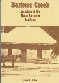
Book - BARKERS CREEK BIRTHPLACE OF THE MOUNT ALEXANDER GOLDFIELDS, c1999
Barkers Creek Birthplace of the Mount Alexander Goldfields. Publisher: Howard Carr, Barkers Creek. ISBN: 0-646-37984-4. 168 pages. Photographs, illustrations & maps. Signed by Howard CarrHoward A Carrgoldfields, barkers creek -
 Whitehorse Historical Society Inc.
Document, Land under threat, 1981
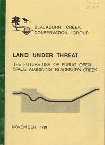
'Land under threat: the future use of public open space adjoining Blackburn Creek' by Blackburn Creek Conservation Group, November 1981.'Land under threat: the future use of public open space adjoining Blackburn Creek' by Blackburn Creek Conservation Group, November 1981. Includes detailed descriptions, plans, bird lists, correspondence.'Land under threat: the future use of public open space adjoining Blackburn Creek' by Blackburn Creek Conservation Group, November 1981.blackburn creek, parks and reserves, kalang park, furness park, environment, blackburn creek conservation group, blacks walk, blackburn creeklands, melbourne and metropolitan board of works, city of nunawading, burgess, graham -
 Lakes Entrance Historical Society
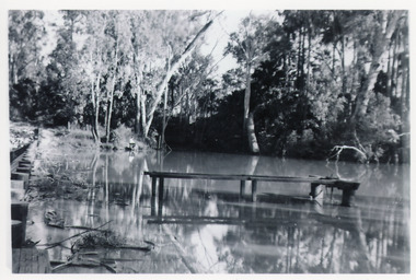
Photograph - Mississippi Creek Landing, 1950
From 1910c to 1940c stone was bought from quarry by tramline to the entrance and other sites around the lakes for stabilisation works.Black and white photograph of a derelict landing at Mississippi Creek, North Arm, showing remains of piles without decking on bank, unattached jetty in water. Creek surrounded by trees. East Gippsland Victoriatransport, waterways -
 Lakes Entrance Historical Society
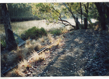
Photograph - Tramline, Fish Marie, 1997
Date made 18 January 1997Colour photograph of a remnant of the tramway which ran from the Mississippi Creek quarry to the head of the North Arm. It shows two lengths of discarded iron rail on the bank of the creek. Lakes Entrance Victoriawaterways, public works, transport, historic site -
 Flagstaff Hill Maritime Museum and Village
Photograph, C. 1891
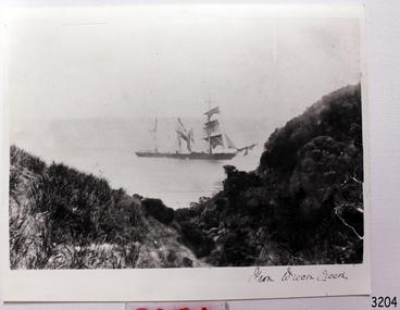
Photograph shows the ship FIJI where she met her demise, in Wreck Bay, on the shipwreck coast of South West Victoria. The three-masted iron barque Fiji had been built in Belfast, Ireland, in 1875 by Harland and Wolfe for a Liverpool based shipping company. The ship departed Hamburg on 22nd May 1891 bound for Melbourne, under the command of Captain William Vickers with a crew of 25. The ship’s manifest shows that she was loaded with a cargo of 260 cases of dynamite, pig iron, steel goods, spirits (whisky, schnapps, gin, brandy), sailcloth, tobacco, coiled fencing wire, concrete, 400 German pianos (Sweet Hapsburg), concertinas and other musical instruments, artists supplies including brushes, porcelain, furniture, china, and general cargo including candles. There were also toys in anticipation for Christmas, including wooden rocking horses, miniature ships, dolls with china limbs and rubber balls. On September 5th, one hundred days out from Hamburg in squally and boisterous south west winds the Cape Otway light was sighted on a bearing differing from Captain Vickers’ calculation of his position. At about 2:30am, Sunday 6th September 1891 land was reported 4-5 miles off the port bow. The captain tried to put the ship on the other tack, but she would not respond. He then tried to turn her the other way but just as the manoeuvre was being completed the Fiji struck rock only 300 yards (274 metres) from shore. The place is known as Wreck Bay, Moonlight Head. Blue lights were burned and rockets fired whilst an effort was made to lower boats but all capsized or swamped and smashed to pieces. Two of the younger crewmen volunteered to swim for the shore, taking a line. One, a Russian named Daniel Carkland, drowned after he was swept away when the line broke. The other, 17 year old able seaman Julius Gebauhr, a German, reached shore safely on his second attempt but without the line, which he had cut lose with his sheath-knife when it become tangled in kelp. He rested on the beach a while then climbed the steep cliffs in search of help. At about 10am on the Sunday morning a party of land selectors - including F. J. Stansmore, Leslie Dickson (or Dixon) and Mott - found Gebauhr. They were near Ryans Den, on their travels on horseback from Princetown towards Moonlight Head, and about 5km from the wreck. Gebauhr was lying in the scrub in a poor state, bleeding and dressed only in singlet, socks and a belt with his sheath-knife, ready for all emergencies. At first they were concerned about his wild and shaggy looking state and what seemed to be gibberish speech, taking him to be an escaped lunatic. They were reassured after he threw his knife away and realised that he was speaking half-English, half-German. They gave him food and brandy and some clothing and were then able to gain information about the wreck. Some of the men took him to Rivernook, a nearby guest house owned by John Evans, where he was cared for. Stansmore and Dickson rode off to try and summon help. Others went down to the site of the wreck. Messages for rescuing the rest of the crew were sent both to Port Campbell for the rocket rescue crew and to Warrnambool for the lifeboat. The S.S. Casino sailed from Portland towards the scene. After travelling the 25 miles to the scene, half of the Port Campbell rocket crew and equipment arrived and set up the rocket tripod on the beach below the cliffs. By this time the crew of the Fiji had been clinging to the jib-boom for almost 15 hours, calling frantically for help. Mr Tregear from the Rocket Crew fired the line. The light line broke and the rocket was carried away. A second line was successfully fired across the ship and made fast. The anxious sailors then attempted to come ashore along the line but, with as many as five at a time, the line sagged considerably and some were washed off. Others, nearly exhausted, had to then make their way through masses of seaweed and were often smothered by waves. Only 14 of the 24 who had remained on the ship made it to shore. Many onlookers on the beach took it in turns to go into the surf and drag half-drowned seamen to safety. These rescuers included Bill (William James) Robe, Edwin Vinge, Hugh Cameron, Fenelon Mott, Arthur Wilkinson and Peter Carmody. (Peter Carmody was also involved in the rescue of men from the Newfield.) Arthur Wilkinson, a 29 year old land selector, swam out to the aid of one of the ship’s crewmen, a carpenter named John Plunken. Plunken was attempting to swim from the Fiji to the shore. Two or three times both men almost reached the shore but were washed back to the wreck. A line was thrown to them and they were both hauled aboard. It was thought that Wilkinson struck his head on the anchor before s they were brought up. He remained unconscious. The carpenter survived this ordeal but Wilkinson later died and his body was washed up the next day. It was 26 year old Bill Robe who hauled out the last man, the captain, who had become tangled in the kelp. The wreck of the Fiji was smashed apart within 20 minutes of the captain being brought ashore, and it settled in about 6m of water. Of the 26 men on the Fiji, 11 in total lost their lives. The remains of 7 bodies were washed onto the beach and their coffins were made from timbers from the wrecked Fiji. They were buried on the cliff top above the wreck. The survivors were warmed by fires on the beach then taken to Rivernook and cared for over the next few days. Funds were raised by local communities soon after the wreck in aid of the sufferers of the Fiji disaster. Captain Vickers was severely reprimanded for his mishandling of the ship. His Masters Certificate was suspended for 12 months. At the time there was also a great deal of public criticism at the slow and disorganised rescue attempt to save those on board. The important canvas ‘breech buoy’ or ‘bucket chair’ and the heavy line from the Rocket Rescue was in the half of the rocket outfit that didn’t make it in time for the rescue: they had been delayed at the Gellibrand River ferry. Communications to Warrnambool were down so the call for help didn’t get through on time and the two or three boats that had been notified of the wreck failed to reach it in time. Much looting occurred of the cargo that washed up on the shore, with nearly every visitor leaving the beach with bulky pockets. One looter was caught with a small load of red and white rubber balls, which were duly confiscated and he was ‘detained’ for 14 days. Essence of peppermint mysteriously turned up in many settlers homes. Sailcloth was salvaged and used for horse rugs and tent flies. Soon after the wreck “Fiji tobacco” was being advertised around Victoria. A Customs officer, trying to prevent some of the looting, was assaulted by looters and thrown over a steep cliff. He managed to cling to a bush lower down until rescued. In 1894 some coiled fencing wire was salvaged from the wreck. Hundreds of coils are still strewn over the site of the wreck, encrusted and solidified. The hull is broken but the vessel’s iron ribs can be seen along with some of the cargo of concrete and pig iron. Captain Vickers presented Bill Robe with his silver-cased pocket watch, the only possession that he still had, as a token for having saved his life and the lives of some of the crew. (The pocket watch came with 2 winding keys, one to wind it and one to change the hands.) Years later Bill passed the watch to his brother-in-law Gib (Gilbert) Hulands as payment of a debt and it has been passed down the family to Gilbert Hulands’ grandson, John Hulands. Seaman Julius Gebauhr later gave his knife, in its hand crafted leather sheath, to F. J. Stansmore for caring for him when he came ashore. The knife handle had a personal inscription on it. A marble headstone on the 200m high cliffs overlooking Wreck Beach, west of Moonlight Head, paying tribute to the men who lost their lives when Fiji ran aground. The scene of the wreck is marked by the anchor from the Fiji, erected by Warrnambool skin divers in 1967. Amongst the artefacts salvaged from the Fiji are china miniature animals, limbs from small china dolls, rubber balls, a slate pencil, a glass bottle, sample of rope from the distress rocket and a candlestick holder. These items are now part of the Fiji collection at Flagstaff Hill Maritime Museum, along with Captain Vickers’ pocket watch and Julius Gebauhr’s sheath knife. Flagstaff Hill’s Fiji collection is of historical significance at a State level because of its association with the wreck Fiji, which is on the Victorian Heritage Register VHR S259. The Fiji is archaeologically significant as the wreck of a typical 19th century international sailing ship with cargo. It is educationally and recreationally significant as one of Victoria's most spectacular historic shipwreck dive sites with structural features and remains of the cargo evident. It also represents aspects of Victoria’s shipping history and its potential to interpret sub-theme 1.5 of Victoria’s Framework of Historical Themes (living with natural processes). The Fiji collection meets the following criteria for assessment: Criterion A: Importance to the course, or pattern, of Victoria’s cultural history. Criterion B: Possession of uncommon, rare or endangered aspects of Victoria’s cultural history Criterion C: Potential to yield information that will contribute to an understanding of Victoria’s cultural history. Black and White Photograph of the ship "Fiji" taken from Wreck Creek. warrnambool, shipwrecked coast, flagstaff hill, flagstaff hill maritime museum, maritime museum, shipwreck coast, flagstaff hill maritime village, shipwrecked artefact, pocket watch, fob watch fiji, william vickers, william robe, bill robe, gebauhr, stansmore, carmody, wreck bay, moonlight head, fiji shipwreck 1891, port campbell rocket crew, wreck bay victoria -
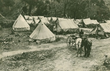
 Lorne Historical Society
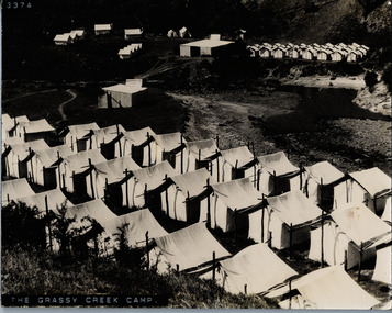
Photograph, The Grassy Creek Camp
Close up photograph of tents and site camp at Grassy Creek G.O.Rg.o.r. country roads board camp site - construction grassy creek -
 Lorne Historical Society
Photograph, Bell Tents at Bridge near Grassy Creek 1920
Tent encampment and horse trap near Grassy Creek Bridge 1920 -
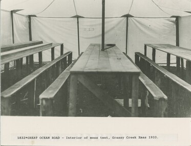 Lorne Historical Society
Photograph, Interior of mess tent at Grassy Creek Christmas 1933
Photograph showing the interior of the mess tent at Grassy Creek Christmas 1933christmas 1933, mess-tent at grassy-creek -
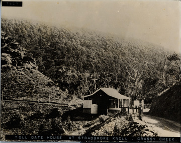 Lorne Historical Society
Photograph, Tolgate house at Stradbroke Knoll, Grassy Creek
Photograph showing Toll Gate House at Stradbroke Knoll, Grassy Creekg.o.r; toll-gate-house: stradbroke-knoll; grassy-creek; -
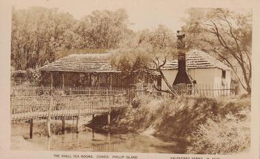 Phillip Island and District Historical Society Inc.
Photograph
Part of collection donated to the Museum by Mr. Bernard Grayden. 1975Postcard showing bridge across creek leading to The Shell Tea Rooms.The Shell Tea rooms, Cowes, Phillip Island. Valentine Series M4845local history, documents, postcards, tea rooms, cowes, phillip island, sepia postcard, the shell tea rooms, bernard grayden -
 Glenelg Shire Council Cultural Collection
Photograph - Photograph - Road bridge over a creek, n.d
Black and white photo of road bridge over a creek, rural setting.Front: '1903' - handwritten, blue pen -
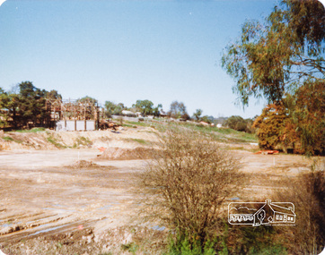 Eltham District Historical Society Inc
Photograph, Peter Bassett-Smith, Construction of Eltham Community Centre, June 1977, 1977
The valley of Diamond Creek, Eltham looking south from Bridge Streeteltham, eltham community centre, buildings, construction -
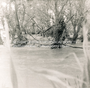 Eltham District Historical Society Inc
Photograph, George W. Bell, Flood Eltham early 1950's, 1950c
Black and white photograph of Diamond Creek in flood at Eltham early 1950sfloods, diamond creek, eltham, george w bell collection -
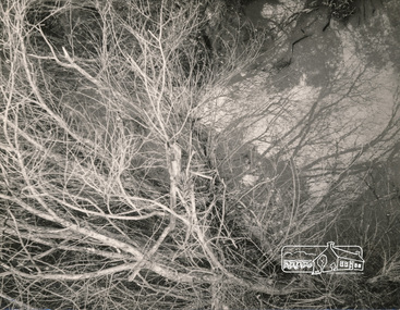 Eltham District Historical Society Inc
Photograph, George W. Bell, Beside Diamond Creek, 1965, 1965
Black and white photograph of creekside vegetation, Diamond Creek, Eltham, 1965.diamond creek, eltham, vegetation, george w bell collection -
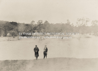 Eltham District Historical Society Inc
Photograph, Diamond Creek in flood 1924, 1924
Colour photograph of original showing Diamond Creek in flood at Eltham 1924floods, diamond creek, eltham -
Eltham District Historical Society Inc
Folder, Cornelius Sharp Haley
Folder of information on Cornelius Sharp Haley, Upper Diamond Creek (Hurstbridge)cornelius sharp haley -
Eltham District Historical Society Inc
Folder, William Wandless Herbert and John Herbert, 1890s
Folder of information on Herbert Family, Diamond Creek and Doreen, late 1800s.william wandless herbert, john herbert, elizabeth herbert, martha herbert, annie herbert, elizabeth herbert, isabelle herbert, william herbert, andrew herbert, george herbert -
Eltham District Historical Society Inc
Folder, McClelland and Hunniford, 1852
Folder of information on Hunniford and McClelland, leaseholders, east of Diamond Creek, 1852hunniford, george mcclelland -
 Ringwood and District Historical Society
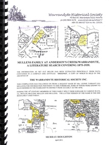
Book, Mullens Family at Anderson's Creek/Warrandyte
Covering Mullen's Family at Anderson's Creek/Warrandyte from 1875 to 1939 -
 Bendigo Historical Society Inc.
Newspaper - JACK PERRY COLLECTION: NEWSPAPERBENDIGO CREEK
Newspaper article, Bendigo Weekly. Discusses Bendigo Creek and Rosalind Park.person, individual, jack perry, bendigo creek, rosalind park -
 Bendigo Historical Society Inc.
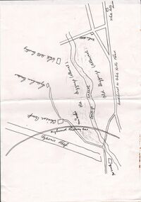
Document - CONSTABLE RYAN COLLECTION: SKETCH MAP OF BENDIGO CREEK
Sketch map of Bendigo creek, Chinese camp and White Hills cemetery.map, bendigo, white hills -
 Bendigo Historical Society Inc.
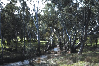
Slide - BENDIGO VIEWS, Aug 1964
Slide. Bendigo Views. A small flowing creek with trees and grass on the banks.slide, bendigo, bendigo views, bendigo views -
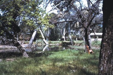
 Bendigo Historical Society Inc.
Slide - BENDIGO VIEWS, Jun 1968
Slide. Bendigo Views. View of a tree lined creek with a road nearby.slide, bendigo, bendigo views, bendigo views -
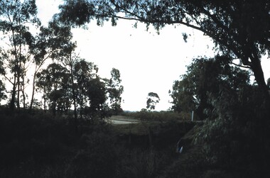
 Bendigo Historical Society Inc.
Slide - BENDIGO VIEWS, Oct 1963
Slide. Bendigo Views. Scene with trees along the creek at the Botanical Gardens.slide, bendigo, bendigo views, bendigo views