Showing 3015 items
matching miles
-
 Victorian Harness Racing Heritage Collection at Lord's Raceway Bendigo
Photograph - Framed photo finish, Greg Matthews Photo, Lincoln Star, 22 February 1978
Lincoln Star won the Bendigo Pacing Cup on the 22 February 1978, followed by Mark Radium and Diamond Charger. Lincoln Star owned by Mr & Mrs RB Conroy, was trained and driven by RB Conroy. Lincoln Star raced from 1974 (2yo) through to 1979 (7yo). Career: 29 wins 15 seconds 19 thirds 139 starts. Refer to Identifier 15.178 (Media) for Full Career Performance Record.Two colour photographs, one small one large in a white frame. At the top: Bendigo Trotting Club 22-2-78/ Pacing Cup At the bottom: Left corner: Distance 2700 metres/ Mile rate 2.5 / Greg Matthews Photo Centre: Lincoln Star (Royal Dollar - Flora Scott) / Mark Radium 2nd / Diamond Charger 3rd Right corner: Owned by- Mr & Mrs RB Conroy/ Trained and driven by - RB Conroybendigo harness racing club, horses, race, winner, bendigo trotting club, pacing cup, driver, trainer, owner, 1978, lincoln star, mr & mrs rb conroy, mark radium, diamond charger, rb conroy, bob conroy, r conroy -
 Victorian Harness Racing Heritage Collection at Lord's Raceway Bendigo
Photograph - Framed photo finish, Greg Matthews Photo, Chapel Elect, 20 January 1976
Chapel Elect won the Bendigo Pacing Cup on the 20 January 1976, followed by King's Mead and Thoron. Chapel Elect owned by MJ Tate, was trained and driven by K Pocock. Chapel Elect raced from 1974 (3yo) through to 1978 (7yo). Career: 17 wins 9 seconds 8 thirds 79 starts.Three colour photographs, two small one large in a white frame. At the top: Bendigo Trotting Club 20-1-76/ Bendigo Pacing Cup At the bottom: Left corner: Distance 2615 metres/ Mile rate 2.7.2/5 / Greg Matthews Photo Centre: Chapel Elect (Chapel Chief - Lady Pat) / King's Mead 2nd / Thoron 3rd Right corner: Owned by- MJ Tate/ Trained and driven by - K Pocockbendigo harness racing club, horses, race, winner, bendigo trotting club, pacing cup, driver, trainer, owner, 1976, chapel elect, mj tate, king's mead, thoron, ken pocock, ke pocock, k pocock, a robinson, alan robinson -
 Victorian Harness Racing Heritage Collection at Lord's Raceway Bendigo
Photograph - Framed photo finish, BK Matthews Photo, Gallagher, 22 January 1974
Gallagher won the Bendigo Pacing Cup on the 22 January 1974, followed by Royal Gaze and Agitator. Gallagher owned by Mr & Mrs G Rothacker, was trained and driven by G Rothacker. Gallagher raced from 1972 (2yo) through to 1978 (8yo). Career: 38 wins 19 seconds 29 thirds 139 starts. Refer to Identifier 15.117 (Media) for Full Career Performance Record.Two colour photographs, one small one large in a white frame. At the top: Bendigo Trotting Club 22-1-74/ Bendigo Pacing Cup At the bottom: Left corner: Distance 2212 metres/ Mile rate 2.9.4/5 / BK Matthews Photo Centre: Won by Gallagher (Grand Monarch - Angelique) / Royal Gaze 2nd / Agitator 3rd Right corner: Owned by- Mr & Mrs G Rothacker/ Trained and driven by - G Rothackerbendigo harness racing club, horses, race, winner, bendigo trotting club, pacing cup, driver, trainer, owner, 1974, gallagher, mr & mrs g rothacker, g rothacker, royal gaze, agitator, gordon rothacker, gw rothacker -
 Victorian Harness Racing Heritage Collection at Lord's Raceway Bendigo
Photograph - Framed photo finish, Greg Matthews Photo, Freedom Day, 16 January 1979
Freedom Day won the Bendigo Pacing Cup on the 16 January 1979, followed by Split The Deck and Spring Find. Freedom Day owned by Mr S Brain, was trained and driven by KD Murray. Freedom Day raced from 1976 (2yo) through to 1982 (8yo). Career: 23 wins 25 seconds 16 thirds 175 starts.Two colour photographs, one small one large in a white frame. At the top: Bendigo Trotting Club 16-1-79/ Pacing Cup At the bottom: Left corner: Distance 2700 metres/ Mile rate 2.05-2/5 / Greg Matthews Photo Centre: Freedom Day (Minuteman - Beauty Vance) / Split The Deck 2nd / Spring Find 3rd Right corner: Owned by- Mr S Brain/ Trained and driven by - KD Murraybendigo harness racing club, horses, race, winner, bendigo trotting club, pacing cup, driver, trainer, owner, 1979, freedom day, kd murray, mr s brain, split the deck, spring find, kevin murray -
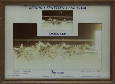 Victorian Harness Racing Heritage Collection at Lord's Raceway Bendigo
Photograph - Framed photo finish, Greg Matthews Photo, Taronga, 13 January 1981
Taronga won the Bendigo Pacing Cup on the 13 January 1981, followed by High Moore and Justin Hanover. Taronga owned by BW & VJ Ellis, was trained and driven by C Powell. Taronga raced from 1976 (3yo) through to 1981 (8yo). Career: 22 wins 15 seconds 20 thirds 138 starts.Two colour photographs, one small one large in a brown frame. At the top: Bendigo Trotting Club 13-1-81/ Pacing Cup At the bottom: Left corner: Distance 2300 metres/ Mile rate 2.03-1/5 / Greg Matthews Photo Centre: Taronga (General Scott - Avian Debra) / High Moore 2nd / Justin Hanover 3rd Right corner: Owned by- BW & VJ Ellis/ Trained and driven by - C Powellbendigo harness racing club, horses, race, winner, bendigo trotting club, pacing cup, driver, trainer, owner, 1981, taronga, c powell, bw & vj ellis, high moore, justin hanover, cliff powell, ch powell -
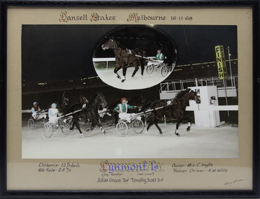 Victorian Harness Racing Heritage Collection at Lord's Raceway Bendigo
Photograph - Framed photo finish, Lynmont, 16 November 1968
Lynmont won the Lansell Stakes at Melbourne Showgrounds on the 16 November 1968, followed by Adios Green and Timothy Scott. Lynmont owned by Mrs C Inglis, was trained and driven by KW Wills. Two colour photographs, one small one large in a black frame. At the top: Lansell Stakes/ Melbourne / 16-11-68 At the bottom: Left corner: Distance 12 1/2 furls / Mile rate 2 -8 2/5 Centre: Lynmont 1st (Gay Reveller - Free Lass) / Adios Green 2nd / Timothy Scott 3rd Right corner: Owner Mrs C Inglis / Trainer - Driver KW Willshorses, race, winner, driver, trainer, owner, melbourne, showgrounds, 1968, lynmont, kw wills, mrs c inglis, adios green, timothy scott, ken wills -
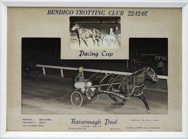 Victorian Harness Racing Heritage Collection at Lord's Raceway Bendigo
Photograph - Framed photo finish, Greg Matthews Photo, Raiarmagh Pool, 22 December 1967
Raiarmagh Pool won the Bendigo Pacing Cup on the 22 December 1967, followed by Ballon D'Essai and Optical. Raiarmagh Pool owned by Mr and Mrs Evans, was trained and driven by Gordon Rothacker. Raiarmagh Pool raced from 1966 (4yo) through to 1968 (6yo). Career: 20 wins 1 second 0 thirds 26 starts. Refer to Identifier 15.230 (Media) for Full Career Performance Record.Two colour photographs, one small one large in a white frame. At the top: Bendigo Trotting Club 22-12-67/ Pacing Cup At the bottom: Left corner: Distance 2600 metres/ Mile rate 2.8-1/5 / Greg Matthews Photo Centre: Raiarmagh Pool ( Raiarmagh - Main Pool) / Ballon d'essai 2nd / Optical 3rd Right corner: Owned by- Mr & Mrs G. Evans/ Trained and driven by - G. Rothackerbendigo harness racing club, horses, race, winner, bendigo trotting club, pacing cup, raiarmagh pool, gordon rothacker, driver, trainer, owner, 1967, ballon d'essai, optical, g rothacker, gw rothacker, g evans -
 Ballarat Tramway Museum
Document - Report, Melbourne and Metropolitan Tramways Board (MMTB), "Report and Statement of Accounts" for year ended 30 June 1958, 1959, 1960, 1958-1960
1215.1 - Annual report of the MMTB for the year end 30/6/1958 - No. 39 - buff heavy paper cover with 56 pages on inside giving details of the MMTB Board, Officers, Balance Sheet, Statement of funds, operation, schedule of debenture, investments, Auditors reports, record of Annual traffic receipts, passengers, miles etc, tram and bus routes operated, statistical information, graphs and photographs. Photos include 2 of Influenza inoculations, traffic congestion in Collins St., new tram track in Malvern area, and new depot entrance at Camberwell. Has an insert inside front cover "With the Compliments of the Melbourne and Metropolitan Tramways Board." 1215.2 - 2 copies - Annual report of the MMTB for the year end 30/6/1959 - No. 40 - light green heavy paper cover with 60 pages on inside giving details of the MMTB Board, Officers, Balance Sheet, Statement of funds, operation, schedule of debenture, investments, Auditors reports, record of Annual traffic receipts, passengers, miles etc, tram and bus routes operated, statistical information, graphs and photographs. Photos include reconstruction of Batman Ave., laying special work at Kew Junction, pouring concrete in Johnston St., cable tramway abandonment, new thermit welding process, new dressing sheds at Wattle Park, illuminated tramcar for the City of Fitzroy centenary. Has an insert inside front cover "With the Compliments of the Melbourne and Metropolitan Tramways Board." 1215.3 - Annual report of the MMTB for the year end 30/6/1960 - No. 41 - light grey heavy paper cover with 60 pages on inside giving details of the MMTB Board, Officers, Balance Sheet, Statement of funds, operation, schedule of debenture, investments, Auditors reports, record of Annual traffic receipts, passengers, miles etc, tram and bus routes operated, statistical information, graphs and photographs. Photos include new St Kilda junction trackwork being assembled in Sth Melbourne yard, Flinders St. overpass under construction, - temporary trackwork, wheel welding machine at Preston, bus drivers school, new golf club house at Wattle Park, Q class tram decorated for Myers Christmas 1959. Has an insert inside front cover "With the Compliments of the Melbourne and Metropolitan Tramways Board." Printer not given on 1215.31215.1 - in ink on the front cover "Mr Major". On page 34 in pencil some notations re figures. 1215.2 - copy 2 - in ink on the front cover "Mr Major". 1215.3 - in light colour ink on front cover "Mr. B.F.Becher"trams, tramways, mmtb, melbourne, annual reports, operations, trackwork -
 Ballarat Tramway Museum
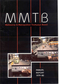
Document - Report, Melbourne and Metropolitan Tramways Board (MMTB), MMTB Reports 1979 to 1981, 1980 to 1982
Three copies of the Annual report of the MMTB for the years end 1980, 1981 and 1982 3953.1 - "Annual Report 1979-80" - white gloss paper with colour card covers with 36 pages, gloss, on inside giving details of the MMTB Board, Officers, Operations report, schedule of debenture, investments, Auditors reports, record of Annual traffic receipts, passengers, miles etc, tram and bus routes operated, statistical information, graphs and photographs. Photos include; Z 117 in Bourke St, Z 31 Burwood terminus, new safety tower wagon, Z118 in Bourke St, W2 528 High St Kew, reconstruction of High St Kew, Z3 120, cable and electric trams at Flemington Bridge, Z3 117, fitting trams to bogies at Preston workshops, Queens Bridge roundabout, MAN bus, Burwood substation, Z111 in Bourke St and Z's enter Elizabeth St service and Z3 129 on rear cover at night. 3953.2 - "Annual Report 1980-81" - white gloss paper with colour card covers with 36 pages, on inside giving details of the MMTB Board, Officers, Operations report, schedule of debenture, investments, Auditors reports, record of Annual traffic receipts, passengers, miles etc, tram and bus routes operated, statistical information, graphs and photographs. Photos include; image of Park St, Domain Road Jtn before changes, Museum station entrance, Flinders and Swanston St, CDB City Ring bus service, Swanston St, Westgate bus route, Park St, new substation, Swanston and Flinders St, Flinders land, and give way to buses pulling out of stops. 3953.2 - "Annual Report 1981-82" - white gloss paper with colour card covers with 36 pages, on inside giving details of the MMTB Board, Officers, Operations report, schedule of debenture, investments, Auditors reports, record of Annual traffic receipts, passengers, miles etc, tram and bus routes operated, statistical information, graphs and photographs. Photos include images of a z class crossing the Maribyrnong bridge, Footscray bus workshops, track renewals, a wedding at Wattle Park, a W2 arriving at Museum Station, Clifton Hill interchange, buses, Z class in Elizabeth St (Nos 158 and 43), Z89 in Mt Alexander Road North Essendon and a W2 loaded on a truck for New Zealand.3951.1 - has Graeme Breydon's address stamp on front cover., 3951.2 - ditto, 3951.3 - ditto and on inside of front cover., 3951.6 - "G. Breydon" in pencil on front cover and pencil comments on balance sheet., 3951.7 - dittotrams, tramways, mmtb, melbourne, annual reports, operations, trackwork -
 Orbost & District Historical Society
coloured photograph
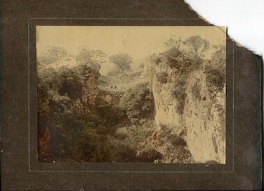
There is no information with this item. "The Pyramids", was named due to huge rocks that jut out from the hill, being shaped similarly to the Egyptian Pyramids. " Where the Murrindal River winds between high limestone bluffs before disappearing into a mountainside and becoming an underground river, four miles north-east of Buchan, is the region known as The Pyramids. It is an area of limestone caverns and sink holes overshadowed by three rock stacks. Some of the caves are the last resting places of long dead Murrindal animals." ( from MBW Walk magazine 1970 - Melbourne Bushwalkers"A hand-painted colour photograph of a view of mountain ranges with men on horses in the background.on front - "Pyramid Gorge Buchan"pyramid-gorge-buchan murrindal limestone-caves -
 Warrnambool and District Historical Society Inc.
Chain link measure, Gunter, Early 20th century
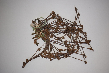
This Gunter’s Chain, an old land surveying instrument, is named after its inventor, Edmund Gunter (1581-1626), an English mathematician and astronomer. It was first produced in 1620. The tool has 100 links and is 66 feet or one chain long. The links are marked off in groups of ten by metal rings or tags. A quarter chain (25 links) is called a rod or pole and ten chains make a furlong and 80 chains make a mile. The traditional cricket pitch is 22 yards or one chain long. This Gunter’s Chain is of considerable significance because: 1. It is an early land measuring tool that was used for over 250 years and has great historical and mathematical significance. A Gunter’s Chain would have been used when forming and building local roads from the earliest days of settlement. 2. It has a possible local connection as it was given to the Historical Society by a local person in 1965 and possibly came from the property of ‘Rosehill’ This is a metal tool which consists of 100 metal pieces or links joined together by loops at each end with two metal loops in between each link. The links joined together form a chain. The two ends of the chain have small metal handles attached At intervals along the chain there are additional rings or metal pieces attached. Some white and green rope material has been used to bundle up the chain. The metal is somewhat rusted. gunter’s chain, land measurement tools, history of warrnambool -
 Eltham District Historical Society Inc
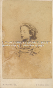
Photograph - Carte de Visite, H.J. Whitlock, Believed to be Fanny Flinn, c.1862
Believed to be Fanny Flinn (wife of artist Walter Herbert Withers) born Handsworth in 1858. Handsworth is situated in greater Birmingham and is 8 miles from the photographer's studio. Photographed by H.J. Whitlock, 11 New Street, Birmingham Henry Joseph Whitlock operated from this address from 1862 to the mid 1890s. This particular carte-de-visite is representative of those he produced in the 1860s. https://www.npg.org.uk/collections/search/person/mp07730/henry-joseph-whitlock also http://www.cartes.freeuk.com/visitors/whit.htmMany items in this collection have suffered from significant water damage and black mouldbirmingham, carte de visite, fanny flinn, john withers collection, h.j. whitlock (photographer) -
 Bendigo Military Museum
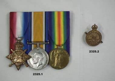
Award - MEDAL SET & BADGE, Post WW1
Horace Eli Hambly No 794 enlisted on 7.12.14 in 3rd reinforcements 4th Light Horse Regt age 20 years 10 months. Embarks for Eygpt 3.2.15, hospital Gallipoli 10.9.15 classed "Enteric", returns to Australia on 20.10.15. He goes AWOL on 24.3.16, classed as a deserter on 17.4.16. He re enlists in NSW on 16.7.17 as David Edward Miles No 7856 3rd Aust Tunneling Coy, he then confesses and embarks for England on 21.11.17, hospital with PUO on 27.6.18, discharged from the AIF on 17.7.19. .1) Medals, court mounted, set of (3) re H.E Hambly. 1. 1914-15 Star. 2. War Medal 1914-19. 3. Victory Medal. .2) "Returned from Active Service Badge". Metal, gold colour, round with crown at top, centre has Rising Sun with AIF under..1) "794 Cpl H.E.Hambly 4 L.H.R A.I.F" .2) "201258"medals, badges, military -
 Puffing Billy Railway
Floodlight Projector, Tilley Model FL6, circa 1940's
Tilley Floodlight Projector - Model FL6 It stands about a metre high, and when lit, turns out about 5,000 candle power from the parabolic mirror in the back of the lamp. manufactured between the mid 1940's and early '50's It runs on kerosene that is pressurized with the integral pump, to provide a light beam from the parabolic mirror in the back of the lamp of approximately 3,000 candle power which can project over 1/4 of a mile. It features a pressure gauge, armored glass and all steel construction. Historic - Railways - Tilley Floodlight ProjectorTilley Floodlight Projector - Model FL6 made of metal, brass and glass and steelTilley Floodlight Projector - Model FL6puffing billy, tilley floodlight projector -
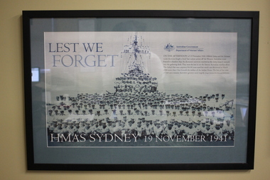 Wangaratta RSL Sub Branch
Framed Poster, HMAS Sydney, Unknown
The striking image on the poster shows men crowded on the deck after the successful action against the Italian Cruiser Bartolomeo Colleoni on 19 July 1940. On 19 November 1941, while returning from convoy duty in Java, HMAS Sydney was engaged by the German armed merchant cruiser Kormoran 130 miles off the West Australian coastline. The faces of many of the 645 servicemen who died in Australia’s greatest naval tragedy feature on this special poster produced to commemorate the anniversary of the loss of the HMAS Sydney. For more than six decades the location of the Sydney had remained a mystery until the wreckages of both HMAS Sydney and the German Armed Merchant Cruiser Kormoran were discovered around 112 nautical miles off Steep Point, Western Australia. The sinking of the Sydney and the loss of all her crew in the Second World War is the single greatest naval tragedy Australia has experienced in Australian waters.Black plastic frame with grey mount containing poster/photograph of Navy crew on ship and in foreground. top left corner - Lest We Forget Bottom of print - HMAS SYDNEY 19 November, 1941 hmas sydney, ww2, 19/11/1941, kormoran, ran -
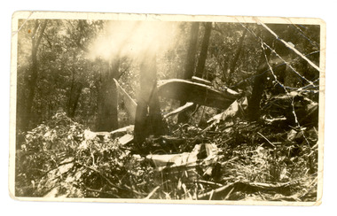 Mt Dandenong & District Historical Society Inc.
Photograph
The aircraft KYEEMA, a Douglas DC-2, crashed into the western face of Mt Dandenong in thick cloud on 25th October 1938. All 18 occupants on board were killed. The aircraft overshot Essendon Airport by 20 miles. The subsequent findings triggered the beginning of air traffic control and the establishment of the Department of Civil Aviation. This photograph was taken in 1938 by First Constable Carl Tepper of Russell Street Police Station. Carl Tepper was a cousin of Frank Child, grandson of Ted Child. They were related through the Dorey family.Sepia photograph showing the wreckage of an aeroplane spread in the forest amongst trees. Sunlight is streaming through a gap in the trees.On reverse: Wreckage of plane crash in Dandenongs flying daily from Adelaide to Melbourne 1930s. No survivors. Taken by late First Constable Carl Tepper Russell Street Police Station.kyeema, carl tepper, frank child, aircraft, aeroplane, crash site, crash, tepper -
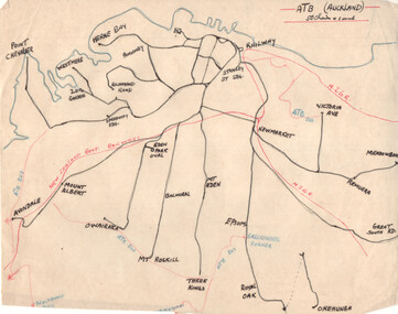 Ballarat Tramway Museum
Drawing - Plan and notes, Wal Jack, Auckland NZ tramways, 1945
Wal Jack had an extensive range of correspondents throughout Australia and the world who often provided him with detailed drawings and notes on various tramway systems. This set of notes on the Auckland tramway system, both the main city, Auckland Tramway Board and the north shore - Takapuna Tramway and Ferry Co shows the various routes, locations and terminals. The hand written sheets provide opening dates of the various routes and gives the total miles and number of cars as at 31-3-1945. Based on the handwriting, prepared by Wal Jack himself.Yields information about Wal Jack's extensive recording and research work.Set of two drawings - black, red and blue ink on quarto size paper and two sheets of notes on the Auckland tramway system c1945.letters, wal jack, drawings, maps, auckland, takapuna nz -
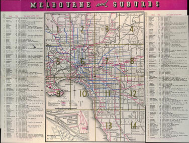 Melbourne Tram Museum
Map, Victorian Railways (VR), "Melbourne and Suburbs", 1956
Map printed by the Victorian Railways in 1955 gives places of interest, some facts about Melbourne, and amusements, with the map showing rail, tram, and railway bus routes, suburbs, golf links, sporting grounds, and municipalities. The Bourke St tram route to East Preston is shown but not the Nicholson St East Brunswick line which opened during mid 1956. Provides a detailed list of suburbs, miles from the GPO, and how reached from where. Notes it was published in Jan. 1956 by the VR Public Relations and Betterment Board.Demonstrates a Victorian Railways printed map of MelbourneMap - 8 fold printed in colourmaps, melbourne, tramways, bus routes, railways -
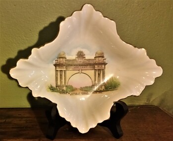 Hymettus Cottage & Garden Ballarat
Decorative object - Porcelain Dish, circa 1920
Souvenir dish featuring transfer print of the Entrance to the Avenue of Honour 14 Miles Long. The print foregrounds the Arch of Victory Ballarat and was made for Ballarat firm of R. Tunbridge & Sons. Early example of fine English porcelain with a new Ballarat landmark for the more discriminating buyer as opposed to the more common mass produced transfer printed items made in Czechoslovakia. The Ballarat Avenue of Honour is the longest surviving such memorial avenue to the Great War in the world and together with its entrance arch was officially opened by the Prince of Wales in June 1920.Souvenir dish made in England for local Australian sales. Evidence of early use of tourism pre-dating later built monuments for an Australian memorial to the Great War.Back stamped "Made in England exlusively for R. Tunbridge & Sons P.L.BALLARAT" with transfer printed Shelley England.porcelain, shelley, tunbridge, avenue of honor, arch of victory. -
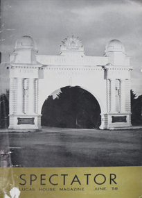 Federation University Historical Collection
Magazine, The Spectator: Lucas House Magazine, 1958, 06/1958
Mazazine on 21 pages featuring a black and white image of the Ballarat Arch of Victory on the front cover. Contents include: * Making Australia's History (John Campbell Miles and Mount Isa) by S. Warren Shears * Cricket Club Notes by Arthur Smith (Doug Mills, Stan Fraser, Tubby Grundy) * Badminton Notes (W. Shears, I. JOnes, T. Hubble, M. Drabsch, Joan Sutherland) * Combating Asian 'Flu (Photo of June Blundell receiving injection from Dr W. Jenkin) * Greater Love (Original short story by L.W.) * Social Page * What is a Boy by Allen Beck Images include photographs of workers on the job, and the Lucas Past Employees Memorial Cairn on the Learmonth end of the Avenue of Honour. e. lucas and co., s. sarori, f. gillies, john tunbridge, lucas memorial cairn -
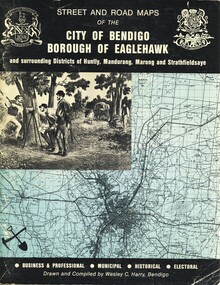 Bendigo Historical Society Inc.
Book - STREET AND ROAD MAPS OF THE CITY OF BENDIGO BOROUGH OF EAGLEHAWK, c1980
Street and Road Maps of the City of Bendigo Borough of Eaglehawk and surrounding Districts of Huntly, Mandurang, Marong and Strathfieldsaye, in color. Drawn and compiled by Wesley C Harry, Bendigo. Publisher: Cambridge Press, Bendigo. ISBN: 9598608.2.2. 68 pages. Photographs, Illustrations & maps. Photos include: Bendigo buildings, scenery mines, streetscapes, parades, pioneer leaders of Bendigo. Many advertisements throughout. List of Justices of the Peace, hospitals, homes for the aged, schools, churches. Page 58: Copy of ''Freedom of the City to the Australian Survey Regiment'' proclamation, 14th June 1970. Maps cover an area of some 169 sq. miles (43,772 hectares). Origin of the name Bendigo. Information on the five Wards of Bendigo, and their councilors. Revised Edition 1986Wesley C Harrybook, bendigo, bendigo & district maps, bendigo and districts map, buildings, streetscapes, historical pictures, advertisements, historical information, commisioners camp, sandhurst -
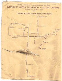 Ballarat Tramway Museum
Poster, State Electricity Commission of Victoria (SECV), "Schedule of Fares and Charges - 26-1-1969", Feb. 1971
704 - Dyeline print of a drawing showing Ballarat Tramway (SEC) Fares, Charges, and Section Map. Also gives charges for Scholar's Monthly tickets, Luggage, Parcels, Newspapers and Chartered trams. Printed from Drawing No. VIX/131/1. Titled "Schedule of Fares and Charges - 26-1-1969". 2nd copy of 704 added 4/10/2015 from donation of Brendan Allan. 704.1 - as above, but with mileages added by the SEC - 26-2-1971 as part of the Transport Regulation Board review of tramway and bus services pending the replacement of the tramways later in 1971. Shows mileages between the various fare points in the nearest 1/4 mile. Two copies held - one rolled longitudinally, the other vertically.trams, tramways, ballarat, fares, sections, map -
 Ballarat Tramway Museum
Slide - 35mm slide/s, Glen Mills, Nov. 1970
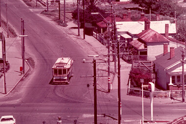
White cardboard mount, 35mm slide, from the Association of Railway Enthusiast's film strip titled "Provincial Tramway Film Strip" of No. 21 or could be 27 taken from the Ballarat (Ballarat East) Fire Station tower. Photo taken Nov. 1970. Has the sign of the AMPOL service station in the foreground. Has destination of Special. Tram at the intersection of Main and Barkly Streets. The film strip notes (Reg. Item 2560), provided the following caption details: "Another 1/2 mile or so saw the "Mt PLEASANT" line turn sharply from the Midland Highway and head towards its terminus in the southern suburbs. - Nov. '70 (Glen Mills)" See image btm2564p.tif for high level scan of image. Stamped on base of slide "11772" and written in ink on top edge "12 Mt Pleasant Line Ballarat"tramways, trams, are, film strip, mt pleasant, barkly st -
 Ballarat Tramway Museum
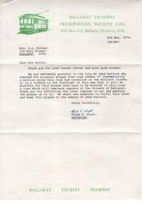
Document - Letter and Envelope, Ballarat Tramway Preservation Society(BTPS) and Mrs. R. L. Butler, May. 1974
Yields information about the plaque that was fitted to tram 27 when it completed 1,000,000 miles.Letter and associated envelope - correspondence between the BTPS and Mrs R. L. Butler regarding the original plaque that belonged to No. 27 - (the Million Mile plaque). .1 - Letter dated 8/5/1974 to Mrs. Butler on BTPS letterhead, signed by Clyde Croft as Secretary - referring the person who recovered the plaque and to the memory of Adam Balloch. .2 - Thankyou letter dated 11/5/1974 from Mrs. Butler to the BTPS - carbon copy. .3 - Envelope with "Ballarat Tourist Tramway" stamped on the bottom left hand edge, addressed to Mrs. Butler and BTPS stamp on rear. Stamp has been cut off. See Reg item 6428 for the initial letter of offer and 6531 for a photo of the sign.trams, tramways, letters, million miles, plaques, btps -
Kew Historical Society Inc
Booklet - Old Kew Golf Links Estate, 1926
Subdivision plans and real estate flyers/brochures reveal a number of aspects of urban development and history. The Kew Historical Society's collection of these plans, as well as advertisements extracted from magazines, cover key aspects of community development and architectural history of Kew and Kew Eat as well as surrounding suburbs. While most of the plans in the collection were gifted to the Society by the former City of Kew, a number of other plans and advertisements have been donated by individuals, of which this is an example.8-page brochure advertising 80 residential home sites for sale in a subdivision called the 'Old Kew Golf Links Estate'. These sites had historic importance in Kew's history as they had previously belonged to Kodak Pty Ltd who were refused permission by Kew Council to use the land for industrial development. The estate, advertised was advertised as being within five miles of Melbourne. The brochure is notable as it includes photographs of Kew East Primary School, the former Kew Golf Club clubhouse, and 'The Moorings' Boathouse (aka Chipperfield's Boat House). The aerial photograph, overlaid with names of notable sites, on the final page is of interest as it shows the area before the intrusion of the Eastern Freeway, which resulted in changing the course of a section of the Yarra River. old kew golf links estate, subdivision -- kew (vic.), subdivisions -- kew east (vic), chipperfield's boathouse, kew east primary school, kew golf club -
 Bendigo Historical Society Inc.
Document - NOTES ON BENDIGO MINES
Handwritten notes on Bendigo Mines. Notes include area of lease, yards along the reef, depth, dividends, main shafts within one mile of Bendigo Station and shafts made safe by the Mines Dept. Mines mentioned are: South New Moon, Carlisle, Nth Garden Gully, Passby, Old Carlisle,Kentish, Central Garden Gully, Golden Fleece, Garden Gully United, Big Blue, Union Co, Red, White & Blue, New Chum Railway, Unity, Cornish, Catherine Reef United, Garden Gully United, Gt Extended Hustlers, Gt Northern, Lady Barkly, New Moon, South St Mungo, Virginia and Victoria Quartz, Document from Albert Richardson Collection of mining history.document, gold, notes on bendigo mines, notes on bendigo mines, south new moon, carlisle, nth garden gully, passby, old carlisle, kentish, central garden gully, golden fleece, garden gully united, big blue, union co, red, white & blue, new chum railway, unity, cornish, catherine reef united, garden gully united, gt extended hustlers, gt northern, lady barkly, new moon, south st mungo, virginia, victoria quartz, graham, tenby and ashman, mr j b watson, geo lansell, mines dept, d e thomas -
 Christ Church Anglican Parish of Warrnambool
Plate, Untitled, Brass Alms dish, C.1902
Brass Collection Plate presented to St Paul's Anglican Church, Allansford, by the mother of Joseph & Frank Dallimore as a Memorial to the two brothers who drowned at Ryan's Den (near Cape Otway) on Jan 1st 1903. Major Joseph Dallimore (aged 32) was on leave from Sth Africa during the war and he, his wife (Beatrice Wiggs) and baby, his brother Frank Rupert Dallimore (aged 22), a farm hand Arthur Geach (aged 19) and a house maid servant, were picnicing at Ryan's Den (near Cape Otway) when the three men went walking, but never returned, all assumed drowned. One theary has it - Mrs M.E. Dallimore was picnicing at Lake Gillear beach when an enormous wave swept over the shore - (much larger than any other during that day) and rolled in all along the beach. This wave may have also reached the area where the three men were walking on the rocks and swept them into the ocean. Only one body was recovered - some 4 weeks later - that of Frank Rupert Dallimore and washed into Brown's Creek, 1 mile from the Johanna River and ten miles east of Ryans Den.It is a memorial plate and records the family's attachment and importance to the Church.Brass engraved and embossed Memorial Collection PlateEmbossed wording around edge of plate in Old English font reads - "All things come of Thee and of Thine own have we given Thee". The inscription on the tondo of the plate reads - "TO THE GLORY OF GOD / AND IN MEMORY OF / JOSEPH & FRANK RUPERT DALLIMORE, / WHO WERE DROWNED AT RYAN'S DEN, / JAN 1ST 1903. / PRESENTED BY THEIR LOVING MOTHER, / M.E.DALLIMORE."brass st pauls anglican church allansford warrnambool church of england christ church parish of warrnambool collection plate memorial plate dallimore drowning ryan s den alms dish -
 Kiewa Valley Historical Society
Black and White photograph of Road Making Machinery, Kiewa Road Making, 25/08/1938
Construction of the main road from South Tawonga to the Bogong High Plains, to provide access to the construction sites for the new Kiewa Hydro Electric Scheme, was commenced early in 1938, the work being undertaken on behalf of the Commission by the Country Roads Board. For the construction work, the Commission purchased three Caterpillar - model R07 - diesel crawler tractors equipped with Kay Brunerei (Brunner) hydraulically operated trailbuilders (angle dozers). This acquisition resulted from a visit to the United States of America in May, 1937 by the Construction Engineer ( Mr. C.H. Kernot) and Assistant Civil Engineer (Mr. J.F. Douglas) where they saw this relatively new type of equipment in use. With the co-operation of the CRB, the Commission demonstrated the operation of these machines at Fishermen's Bend on 6th April, 1938. They were then sent to Kiewa where they commenced operation towards the end of the month. From South Tawonga, the route led immediately across the Western Branch of the Kiewa River necessitating the construction of a bridge 100 feet long. By the end of 1939, the excavation had been 'opened up' for a distance of 19 1/2 miles (approx. 31 km) and of this length, 10 miles (approx. 16 km) had been surfaced.The purchase and use of this type of mechanical equipment in road making was a huge investment, as prior to this most of the work would have been done manually with the use of picks and shovels. Not only were many months of hard manual labour saved, but a very significant amount of time in providing access to the proposed work sites for the new Kiewa Hydro Scheme. This photo is an excellent reminder of how primitive the early machinery was compared to the present but also represents the forward thinking of the State Electricity Commissions engineers in purchasing such innovative equipment . A black and white photograph showing the type of machinery used for road making in the 1930's. It shows a grader being towed by a caterpillar tractor.On the top left hand corner of the photograph , hand written in black ink is the words 'Kiewa Road Making 25/8/1938'. On the right hand side of the photo has been stamped in blue the Number 1. It has been developed on Velox paper (marked on back of photo) with a gloss finish.road making, state electricity commission, caterpillar tractor, kiewa -
 Kiewa Valley Historical Society
Black and White photograph of Road Making Machinery, Kiewa Road Making 25/08/1938 No. 2, 25/08/1938
Construction of the main road from South Tawonga to the Bogong High Plains, to provide access to the construction sites for the new Kiewa Hydro Electric Scheme, was commenced early in 1938, the work being undertaken on behalf of the commission by the Country Roads Board. For the construction work, the Commission purchased three Caterpillar - model R07 - diesel crawler tractors equipped with Kay Brunerei (Brunner) hydraulically operated trailbuilders (angle dozers). This acquisition resulted from a visit to the United States of America in May, 1937 by the Construction Engineer ( Mr. C.H. Kernot) and Assistant Civil Engineer ( Mr. J.F. Douglas) where they saw this relatively new type of equipment in use. With the co-operation of the CRB, the Commission demonstrated the operation of these machines at Fishermen's Bend on 6th April, 1938. They were then sent to Kiewa where they commenced operation towards the end of the month. From South Tawonga, the route let immediately across the Western Branch of the Kiewa River necessitating the construction of a bridge 100 feet long. By the end of 1939, the excavation had been 'opened up' for a distance of 19 1/2 miles (approx. 31 km.) and of this length, 10 miles (approx. 16 km.) had been surfaced. (see KVHS 0328)The purchase of this type of mechanical equipment in road making was a huge investment, as prior to this most of the work would have been done manually with the use of picks and shovels. Not only were many months of hard manual labour saved, but a very significant amount of time in providing access to the proposed work sites for the new Kiewa Hydro Scheme. This photo is an excellent reminder of how primitive the early machinery was compared to the present but also represents the forward thinking of the State Electricity Commissions engineers in purchasing such innovative equipment.A black and white photograph of road making near Mt. Beauty in 1938. Mount Beauty hills can be seen in the background with cleared land for grazing in the fore ground.Hand printed in black ink at the top of the photograph is 'Kiewa Road Making 25/8/1938'. On the right hand corner has been printed the number 2. It has been printed on gloss Velox paper.road making, state electricity commission, caterpillar tractor, kiewa, secv -
 Kiewa Valley Historical Society
Black and White photograph of Road Making Machinery, Kiewa Road Making 25/8/1938(No. 3 in a series of 8), 25/08/1938
Construction of the main road from South Tawonga to the Bogong High Plains, to provide access to the construction sites for the new Kiewa Hydro Electric Scheme, was commenced early in 1938, the work being undertaken on behalf of the Commission by the Country Roads Board. For the construction work, the Commission purchased three Caterpillar - model R07 - diesel crawler tractors equipped with Kay Brunerei (Brunner) hydraulically operated trail builders (angle dozers)). This acquisition resulted from a visit to the United States of America in May, 1937 by the Construction Engineer ( Mr. C.H. Kernot) and Assistant Civil Engineer (Mr. J.F. Douglas) where they saw this relatively new type of equipment in use. With the co-operation of the CRB, the Commission demonstrated the operation of these machines at Fishermen's Bend on 6th April, 1938. They were then sent to Kiewa where they commenced operation towards the end of the month. From South Tawonga, the route led immediately across the Western Branch of the Kiewa River necessitating the construction of a bridge 100 feet long. By the end of 1939,the excavation had been 'opened up' for a distance of 19 1/2 miles (approx. 31 km.) and of this length, 10 miles (approx. 16 km) had been surfaced.The purchase and use of this type of mechanical equipment in road making was a huge investment, as prior to this most of the work would have been done manually with the use of picks and shovels. Not only were many months of hard manual labour saved, but a very significant amount of time in providing access to the proposed work sites for the new Kiewa Hydro Scheme. This photo is an excellent reminder of how primitive the early machinery was compared to the present but also represents the forward thinking of the State Electricity Commission's Engineers in purchasing such new and innovative equipment.A black and white photograph of a Caterpillar diesel crawler tractor and a hydraulically operated trailbuilder (angle dozer) making a road in the Mt. Beauty area.Hand written in black ink in the top left hand corner are the words "Kiewa Road Making 25/8/1938". On the upper right hand of the photograph has been stamped the number 3. On the back is stamped the word 'Velox' severaly times, which is the make of the photograhic paper. roadmaking, caterpillar tractor, kiewa, state electricity commission