Showing 2319 items matching "parishes"
-
 Bacchus Marsh & District Historical Society
Map, Mooradoranook Parish Map, County of Grant
A single page paper map showing the map for the Parish of Mooradanook in the County of Grant. Cadastral map showing land ownership. The map is pasted into a bound volume containing 76 maps or plans in total. High resolution digital image stored on BMDHS computer network. Photo lithographed at the Department of Lands and Survey Melbourne by T. F. McGauran, 27.11.06mooradoranook parish maps, mooradoranook parish plan, bacchus marsh region parish plans -
 Bacchus Marsh & District Historical Society
Map, Mouyong Parish Map, County of Grant
A single page paper map showing the map for the Parish of Mouyong in the County of Grant. Cadastral map showing land ownership. The map is pasted into a bound volume containing 76 maps or plans in total. High resolution digital image stored on BMDHS computer network. Photo lithographed at the Department of Lands and Survey Melbourne by T. F. McGauran, 9. 4. 07mouyong parish plan, mouyong parish maps, bacchus marsh region parish plans -
 Linton and District Historical Society Inc
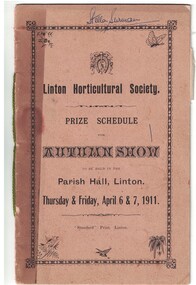
Programme, Linton Horticultural Society, Prize Schedule, Autumn Show, 1911
Printed booklet, brown cover has decorative border and small illustrations of butterflies, birds and plants. Booklet lists categories and prize monies for Linton Horticultural Society's Autumn Show, 1911. Also includes lists of the Society's paid-up members and office bearers, a copy of the Society's rules, and competition regulations. Pages 12Text: " Linton Horticultural Society. / PRIZE SCHEDULE / FOR / AUTUMN SHOW / TO BE HELD IN THE / Parish Hall, Linton. / Thursday & Friday, April 6 & 7, 1911. " "Stella Surman" handwritten across top right-hand side of cover.linton horticultural society, programmes, prizes, members, surman collection -
 Federation University Historical Collection
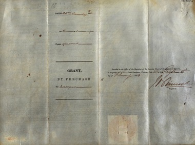
Document, Victoria: Land Purchase, Edward Ager Wynne, 1856, 23 January 1856
.1 Document outlining the purchase of Lot No. 39: 16 acres, 3 roods, 9 perches situated in the County of Talbot, Parish of Glendaruel by Edward Ager Wynne of Melbourne for the sum of Seventeen Pounds Thirteen Shillings .2 Document outlining the purchase of Lot No. 30: 50 acres, 2 roods, 38 perches situated in the County of Talbot, Parish of Glendaruel bu Edward Ager Wynne of Melbourne for the sum of Fifty Pounds Fourteen Shillings and Nine Pence Both documents were witnessed by Major-General Edward Macarthur the Senior, Officer in Command of Our Land Forces Thick cream paper, hand writtenDate: 23 January 1856 Signature: E Macarthur - Major General of Our Land Forces Official Seal county of talbot, parish of glenaruel, acres, roods, perches, edward ager wynne, major-general, edward macarthue, land purchase agreement -
 Greensborough Historical Society
Map - Map (Copy), C. Hodgkinson, District Surveyor et al, Parish of Yan Yean 1856: Village site during construction of the Yan Yean Reservoir, 1978
Copy of map part Sec. 13, Parish of Yan Yean 1856, Map 3, Village site... Scale: 8 chains to 1 inch. Drawn by C. Hodgkinson, District Surveyor, redrawn by A. R. Blair 1978. 1 p. photocopy of map. yan yean reservoir, yan yean -
 Greensborough Historical Society
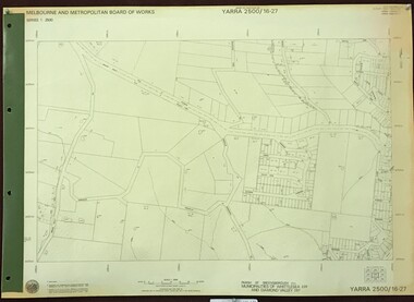
Map, Melbourne and Metropolitan Board of Works. Survey Division, MMBW, Yarra 2500 / 16.22. Research, 1979_05
Melbourne and Metropolitan Board of Works. Yarra 2500 [base map] 16-22. Research. Parish of Nillumbik 3310. Municipalities of Diamond Valley 257 and Eltham 238. Prominent streets include: Orme Road and Allendale Road. MMBW Map in 1:2500 [scale] series. Cream parchment with green tape reinforcing on edges and punched holes on left edge.mmbw, melbourne and metropolitan board of works, shire of diamond valley, diamond creek - maps -
 Bendigo Historical Society Inc.
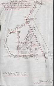
Plan - MCCOLL, RANKIN AND STANISTREET COLLECTION: PLAN OF SURVEY OF DAM SITE, 1941
McColl Rankin & Stanistreet, Plan of Survey of Dam site, Part of Crown Allotment 98 Section C, City of Bendigo, Parish of Sandhurst, County of Bendigo. Signed by Garnet G Birch 1 Feb 1941. 33.5 x 43. Attached is a Copy of Field notes, Dam Site in Crown Allotment 198 Sec. City of Bendigo, Parish of Sandhurst. True Meridian, County of Bendigo, Area 0A 1R 16P. Signed Garnet G Birch, 1/2/1941. Drawn in red and black pen. 20.8 x 33. Both maps are for Deborah Extended Gold Mining Co. No Liabilityorganization, mining, deborah extended gold mining co nl, mccoll rankin & stanistreet, plan of survey of dam site -
 Federation University Historical Collection
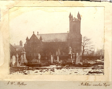
Photo, J.W. Mellor, Holy Trinity, Bardsley and St Michael's and All Angels Church and Cemetery, Ashton-under-Lyne
The Church of St Michael and All Angels dates from the 15th century and is the Parish Church for Ashton under Lyne. It is believed there was a church on this site before the Norman Conquest as the Domesday Book mentions a St Michael's Church in the east of the ancient parish of Manchester. Much of the structure was re-constructed in Victorian times. The church with large windows in Perpendicular style. Buttresses were required with this type of building as the large window area reduced the strength of the walls. The church boasts boasts some of the best examples of fifteenth century stained glass left in Britain. There are eighteen panels illustrating the life of St. Helena. The church tower is 145 feet high and has a peel of thirteen bells. (From ashton-under-lyne.com) Holy Trinity Church, Bardsley was consecrated on the 10th October 1844 by the Bishop of Chester. The church was only the third church in the Borough of Ashton-under-Lyne to be carved out of the parish of St. Michael & All Angels, Ashton. The church was built on land donated by the Hulme Trustees..1) Sepia photograph mounted onto card showing Holy Trinity, Bardsley, Ashton-under-Lyne. Snow is evident in the foreground and the church is surrounded by a graveyard. .2) Sepia photograph mounted onto card showing St Michael's and All Angels church, alongside a graveyard.Signed lower LHS "J.W. Mellor" Lower RHS "Ashton-under-Lyne"cemetery, st michael s and all angels, ashton under lyne, j w mellor, tombstone, tomb stone, headstone, head stone, holy trinity church, bardsley -
 Bendigo Historical Society Inc.
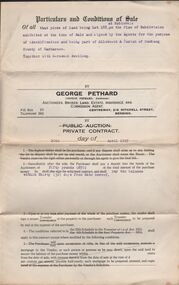
Document - H.A. & S.R. WILKINSON COLLECTION: CONDITION OF SALE
Conditions of sale by private contract dated 29th April, 1925 between H. A. Wilkinson and G. A. Pethard for land being lot 188 at Robinvale part of allotment A Parish of Bumbang County of Karkarooc, together with 6-roomed dwelling. Price 505 pounds and 10 shillings.organization, business, h.a. & s.r wilkinson real estate -
 Bendigo Historical Society Inc.
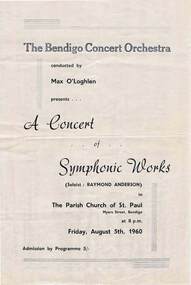
Document - THE BENDIGO CONCERT ORCHESTRA
'The Bendigo Concert Orchestra' conducted by Max O'Loghlen presents 'A Concert of Symphonic Works' (Soloist: Raymond Anderson) in The Parish Church of St. Paul Myers Street, Bendigo at 8 p. m. Friday, August 5th, 1960. Admission by Programme 5/-. Arthur Hocking Print.event, entertainment, music, the bendigo concert orchestra, max o'loghlen, a concert of symphonic works, raymond anderson, arthur hocking print -
 Bendigo Historical Society Inc.
Map - PARISH OF STRATHFIELDSAYE : COUNTY OF BENDIGO, 1-10-19
Map. Parish of Strathfieldsaye, County of Bendigo, Wellsford, Sandhurst, Sedgwick, Eppalock, Axedale. Photo-Lithographed at the Department of Lands and Survey, Melbourne by W.J.Butson, 1-10-19. Price 1/-. By authority A.J. Mullett, Government Printer, Melbourne. (number 34 in map cupboard 1)A.J. Mullett, Govt. Printer, Melbourne.map, bendigo, strathfieldsaye -
Whitehorse Historical Society Inc.
Map, Parish of Nunawading, 1927
Map of the Parish together with part of the Borough of Box Hill.Map of the Parish together with part of the Borough of Box Hill. Includes names of lease or license holders, sizes of leases and in some areas dates of leases. Roads, railway and stations marked. Original survey by W.J.Busocon, 1915. Manuscript note: 15.2.1927 Verified Dept. Lands and Survey.Map of the Parish together with part of the Borough of Box Hill. maps, parish of nunawading, borough of box hill -
Southern Sherbrooke Historical Society Inc.
Map, Dept of land s & Survey, Dandenong Ranges Area Sheet 28, Jan-56
Owned by David Walker, previously of Menzies Creek. Given by him to Rex Breen in 2001 for donation to society.Aerial survey map of parts of Gembrook, Monbulk and Naree Worran parishes (Victoria). Scale: 10 chains to 1 inch, contour interval 20 feet. Shows Menzies Creek and parts of Kallista, Clematis, Selby and Belgrave South. Ringwood D2C or 849D2C, Zone 7"16563" in pen on top left corner of reverse. -
 Bendigo Historical Society Inc.
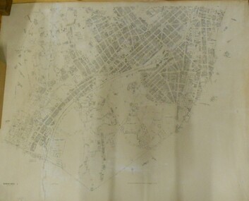
Map - BENDIGO SHEET 2
Parish map showing the southern section of the City of Bendigo. It shows the city boundary running along Murphy Street, Grave (Patterson) Street, and the turns at the south end of Macdougall Road, the corner of Alder and Aspinal Streets and the corner near the Specimen Hill - Marong roads intersectionH.J. Green Govt. Printer, Melbournemap, bendigo, city streets, parish map, city boundary -
 Ringwood and District Historical Society
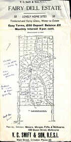
Flyer, Residential Land Sale Sub-division - Fairy Dell Estate, Warranwood, Vic. - circa 1950s
Land sale advertisement for 50 home sites with map of Sub-division showing layout of streets and allotments, summary of local features and services and terms of sale, and copy of sectional map of Crown Allotments 20 & 21B Parish of Warrandyte also showing layout of Sub-division.Subdivision includes Grandview Grove (later Bemboka Road), Merrill Crescent and Kerry Road, Warranwood. Estate Agents - V.C. Swift & Son R.E.S.I., Main Street, Croydon, Phone 20. Solicitors - Morgan, Fyffe & Mulkearns, 108 Queen Street, Melbourne. Handwritten 1970s real estate price notations for some blocks. -
 Bendigo Historical Society Inc.
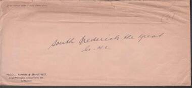
Document - MCCOLL, RANKIN AND STANISTREET COLLECTION: SOUTH FREDERICK THE GREAT CO NL, 1934
McColl Rankin & Stanistreet, South Frederick the Great Co NL. a/ Plan of Residence Areas on No. 10287, by J O Charlton, Parish of Yarraberb. Includes land for school, owners names of blocks, crown land. Signed: Garnet G Birch. Dated 27/4/1935, licensed surveyor. b/ Letter from Department of Mines to McColl Rankin & Stanistreet in reference to letter regarding lease No. 10287. On back of letter are notes relating to blocks of land on lease No.10287. c/ Plan Of Area For On Lease No. 10287 Ben. By John O Charlton. Mining District of Bendigo, Parish of Yarraberb, Lease No. 10287 Ben. By John O Charlton. Mining District of Bendigo. Date 21/6/1934. Signed Garnet G Birch. Blocks include name of purchaser. d/ Plan Of Area For On Lease No. 10287 Ben. By John O Charlton. Mining District of Bendigo, Parish of Yarraberb, County of Bendigo. Dated 21/6/1934. e/ envelope inscribed South Fredrick the Great. 51.organization, business, gold mine, plan of area for on lease no. 10287 ben. by john o charlton. mining district of bendigo, parish of yarraberb, county of bendigo j o charlton garnet g birch department of mines lease no. 10287 ben. by john o charlton mining district of bendigo 1934 -
 Ringwood and District Historical Society
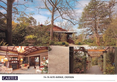
Document, Real Estate History of "Shadowood", 74-76 Alto Avenue, Croydon, Victoria
Folder of Estate Agent's notes compiled in preparation for property auction, 11th October, 2008. Two-page history of "Shadowood", display photo of house with floor plan dating from circa 1920s, copies of LANDATA title documents. Map of Wicklow Hills subdivision, including Alto Avenue, Elesmere Avenue, Glenora Avenue, Wicklow Avenue, and railway line to Lilydale. Title Vol 1323 Fol 264412 Allotment 43C Parish of Warrandyte - Ann McKean, dated 6th October, 1881. Title Vol 1937 Fol 387367 Part of Allotment 43C Parish of Warrandyte - Richard Bonynge Kelly, 11th August, 1887. Title Vol 2728 Fol 543569 Part of Allotment 43C Parish of Warrandyte - Thomas Robertson, 27th July, 1898. Title Vol 4161 Fol 832181 Part of Allotment 43C Parish of Warrandyte - John Gordon Robertson, 4th November, 1918. Title Vol 4490 Fol 897808 Lots 82 and 83, Plan of Subdivision 7478 - Elizabeth Rutherford Morell, 12th August, 1921. Title Vol 4617 Fol 923322 Lot 82, Plan of Subdivision 7478 - Flora Clapperton, 23rd September, 1922. Title Vol 8409 Fol 533, part of Lot 82, Plan of Subdivision 7478 - Hugh Ravenscroft Hastings Wettenhall and Sybella Anne Wettenhall, 1st May, 1962. -
 Greensborough Historical Society
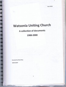
Document - Document Collection, Watsonia Uniting Church, Watsonia Uniting Church: a collection of documents 1988-2000, 1988-2000
Documents collected by Watsonia Uniting Church member Rosie Bray from 1988-2000. Includes planning documents, newspaper clippings, Parish council notes, advertisements for activities, a handbook for the placement of ministers, a mission statement and privacy policy.Plastic folder with blue cover and black plastic binding containing approx 16 documents.watsonia uniting church, uniting church in australia -
Ringwood and District Historical Society
Programme, ANA Ringwood Branch - Programme of Toast List, 1935, 4-Sep-35
Programme of Toast List for the third "Smoke Social" held in the Parish Hall, Ringwood Street on Monday 9th September 1935 of the Australian Natives Association, Ringwood Branch. Visit also of Chief President Mr P.J. Toohey J.P.Buff coloured cardboard with black printing on both sides - Australian Natives Association, Ringwood Branch. +Additional Keywords: Toohey, Mr P.J. -
 Galen Catholic College
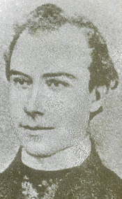
Father George Devitt Galen
Galen Catholic College was named after Father George Devitt Galen, who was a parish priest based at St. Patrick's Church in Wangaratta from 1863 until his death in 1869. This is one of the few photographs of Father Galen.galen catholic college, galen college, father george devitt galen, parish, st. patricks, wangaratta -
 Uniting Church Archives - Synod of Victoria
Photograph, 1985
Rev. Minchin was Tasmanian Moderator in 1985. He was a secondary teacher in Victoria before studying at the United Faculty of Theology from 1970 to 1972. His first parishes were Dartmoor and Sale-Rosedale before coming to Hobart in 1980.B & W head and shoulders studio photograph of the Rev. John Minchin, Moderator of Tasmania."John Minchin Tasmanian Moderator C&N 16/10/1985 page 11"rev john minchin, tasmania, moderator, uniting church -
 Uniting Church Archives - Synod of Victoria
Photograph, 1986
Rev. Minchin was Tasmanian Moderator in 1985. He was a secondary teacher in Victoria before studying at the United Faculty of Theology from 1970 to 1972. His first parishes were Dartmoor and Sale-Rosedale before coming to Hobart in 1980.Informal colour photograph of Rev. Minchin, Dr. Phillips and one other retreat member taken outdoors."Credit Don Ramage Tasmanian moderator, the Rev. John Minchin (right) with Dr. Phillips (centre) and a retreat member C&N 11/6/1986 page 31minchin, john, rev., moderator, tasmania, uniting church -
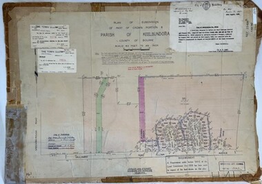 Greensborough Historical Society
Poster - Planning Document, City of Heidelberg et al, Subdivision Plan # H 41 - Crown portion 8, Parish of Keelbundoora - Yallambie, and Crown Portion 9, Parish of Keelbundoora, 1922-1967
Planning Document: Subdivision Plan # H 41 Side 1, Crown portion 8, Parish of Keelbundoora - Yallambie Road, Allima Avenue, Koolya Court, Ekam Court (Jennings Estate). Side 2: Crown Portion 9, Parish of Keelbundoora consist of 5 small subdivision sheets: 1. Somers Avenue, Stewart Terrace, Toubay Street and Railway Place (no date); 2. Somers Avenue, Maxwell Street, Greensborough Road, 1924; 3. Heidelberg Avenue, Golf Avenue, St Andrews Avenue (no date); 4. Birdwood Avenue, May Street (no date); 5. Strathallan Road 1924.An example of hard copy subdivision plans from the Greensborough area. Mainly from the Shire of Diamond Valley era (1964-1994).Plan (2 sided) mounted on heavy card. Stamped and handwritten Council permissions, dates and other details.subdivision plans, city of heidelberg, yallambie, macleod, greensborough -
 Eltham District Historical Society Inc
Document - Survey Plan, Country Roads Board, SP 6801, Eltham-Yarra Glen Road; Brougham St to Bridge St, 1958
1958 C.R.B. Plan of Survey of Part of Crown Portion 12 Section 4 Parish of Nillumbik, County of Evelyn Eltham-Yarra Glen Road, Shire of Eltham Shows Surveyor field notes, property ownership and building type and construction.a.j. collis, a.s. & c.g.h. fitzpatrick, board of land & works, bridge street, brougham steet, commonwealth bank of australia, country roads board, eltham, eltham rsl sub-branch, f.h. collis, f.m. smith, f.n. & e.j. burgoyne, franklin street, h.c. & r.e. burgoyne, j. jorgenson, j.f. & j.e. morris, j.n. & h.c. burgoyne, j.s. blow, john street, main road, p.e. smith, pitt street, r.j. dripps, s.j. taylor, survey plan, trustees of the eltham methodist church, 1958, eltham-yarra glen road, neil webster collection -
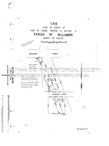 Eltham District Historical Society Inc
Document - Survey Plan, Country Roads Board, SP 6802, Eltham-Yarra Glen Road; Brougham St to Dalton St, 1958
1958 C.R.B. Plan of Survey of Part of Crown Portion 12 Section 4 Parish of Nillumbik, County of Evelyn Eltham-Yarra Glen Road, Shire of Eltham Shows Surveyor field notes, property ownership and building type and construction.1958, eltham-yarra glen road, a.f. munday, bible street, brougham steet, country roads board, dalton street, eltham, j.p. & e.a. sanders, j.w. & e. m. graham, l.c. skipper, l.m. jarrold, main road, napoleon street, survey plan, neil webster collection, franco and co -
 Eltham District Historical Society Inc
Document - Survey Plan, Country Roads Board, SP 6313, Eltham-Yarra Glen Road; Luck St to Henry St, 1956
1956 C.R.B. Plan of Survey of Part of Crown Portion 13 Section 4 Parish of Nillumbik, County of Evelyn Eltham-Yarra Glen Road, Shire of Eltham Shows Surveyor field notes, property ownership and building type and construction.eltham-yarra glen road, country roads board, eltham, main road, survey plan, 1956, a.l. lyon, a.w. brinkkotter, arthur street, c.r. burkett, dudley street, e.n. staff, eltham war memorial trust, henry street, luck street, pryor street, the board of land & works, the equity trustees executors and agency coy ltd, the roman catholic trusts corporation, victorian railways commision, neil webster collection -
 Greensborough Historical Society
Booklet and article, Diamond Valley Local History Tour 2019, by Yarra Plenty Regional Library, 22/10/2019
Cover article written by Rosie Bray. In addition to YPRL booklets which have a brief history of each site visited, there are leaflets on Anglican parish of Diamond Creek; Nillumbik Cemetery; Ellis Cottage; Greensborough Cemetery and Sutherland Homes for ChildrenBooklet (2 copies) containing a brief history of sites visited on the Library's Diamond Valley Tour 2019, with 21 p. of supplementary information by various writers and 6 photographs taken on the tour.diamond valley, yarra plenty regional library, sutherland homes, st katherines church st helena, andrew yandell reserve, greensborough rsl, greensborough war memorial park, greensborough cemetery -
 Greensborough Historical Society
Map, Melbourne and Metropolitan Board of Works. Survey Division, MMBW, Yarra 2500 / 16.27. Hurstbridge, 1977_10
Melbourne and Metropolitan Board of Works. Yarra 2500 [base map] 16.27. Hurstbridge. Parish of Greensborough 2724. Municipalities of Whittlesea 239 and Diamond Valley 257. Prominent streets include: Haleys Gully Road, Kendalls Lane and Bingley Avenue. MMBW Map in 1:2500 [scale] series. Cream parchment with green tape reinforcing on edges and punched holes on left edge.mmbw, melbourne and metropolitan board of works, shire of diamond valley, shire of whittlesea, hurstbridge - maps -
Bendigo Historical Society Inc.
Map - CAMPBELL COLLECTION: BENDIGO & DISTRICT MAPS
Map. Lockwood, Parishes of Lockwood and Shelbourne. Scale 20 chains to 1 inch.Total area 4405 acres. Bullock Creek to the right, Spring Creek at Centre. Newbridge is 11 miles N E, To Marong, Bendigo Lockwood roads are on the left. (number 375 in map cupboard 1)map, bendigo, agricultural lands -
Bendigo Historical Society Inc.
Map - PARISH OF SHELBOURNE : COUNTY OF BENDIGO, 11-12-15
Map. Parish of Shelbourne, County of Bendigo, Marong, Lockwood, Ravenswood, Bradford, Laanecoorie, Woodstock. Photographed at the Department of Lands and Survey, Melbourne by W.J.Butson, 11-12-15. Price 1/-. By authority Albert J. Mullett, Government Printer, Melbourne. (number 32 in map cupboard 1)Albert J. Mullett, Government Printer, Melbourne.map, bendigo, shelbourne