Showing 25579 items matching "plenty-township-estate"
-
 Greensborough Historical Society
Document - Family History, Greg Neumann, The Starling and Stewart families at Janefield, Yan Yean, Greensborough, Diamond Creek, Plenty and Yarrambat, from the late 1850s onward, compiled by Greg Neumann, 2023
Story of the Starling and Stewart families over several generations as farmers in the Plenty-Yarrambat area, compiled by Greg NeumannPrevious version on CD-Rom has been removed and replaced with this Word filestarling family, stewart family, plenty river, plenty, janefield mill, janefield mill on the plenty river, yarrambat -
 Eltham District Historical Society Inc
Audio - Audio Compact Disc, Dr Richard Morton, Dr Richard Morton, Warrandyte Historical Society with Marie Ryan on Magazine, Plenty Valley FM Radio, December 2005
Dr Richard Morton of the Warrandyte Historical Society, speaking with host Marie Ryan of Magazine, on Plenty Valley FM Radio revisiting his presentation of 29 November at the Eltham Living and Learning Centre as part of the Tales of Old Nillumbik presentations, a series of talks held October - December 2005 at the Eltham Living and Learning Centre which allowed Nillumbik Historical Societies to record the verbal history of the area with some of the well known residents of Nillumbik and surrounds Recorded and edited by Marie Ryan of Plenty Valley FM The recording foir Warrandyte Historical Society had issues and so this talk was revisited on Plenty Valley FM Radioaudio recording, north warrandyte, dr richard morton -
 Ringwood and District Historical Society
Photograph, Image used for land sale promotion of Coleman's Heathmont Estate, looking east along Canterbury Road, Heathmont, towards Bedford Road. Sale 15/12/1923 by Public Auction
Written on back of photograph, "Coleman's Heathmont Estate, looking towards Bedford Rd. Sale 15/12/1923 by Public Auction". -
 Ringwood and District Historical Society
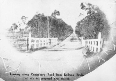
Photograph, 1925 - Ringwood East Railway Station Estate. Photo taken from subdivisional plan land sale
Catalogue card reads, "1925 - Ringwood East Railway Station Estate. Photo taken from subdivisional plan land sale." -
 Ringwood and District Historical Society
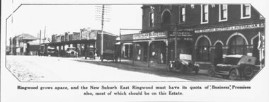
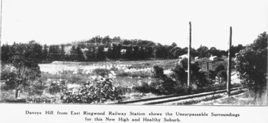
Photograph, Image used for land sale promotion of East Ringwood Railway Estate - 1925. Davey's Hill shown in the photograph later became the site of Maroondah Hospital adjoining Davey Drive, Ringwood East
Catalogue card reads, "Railway Estate 1925. Daveys Hill East Ringwood. Daveys Hill is now Maroondah Hospital ground." -
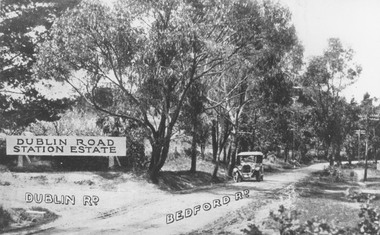 Ringwood and District Historical Society
Photograph, Corner Dublin and Bedford Rds. Ringwood East, 10/11/19. Bloods Estate Sale
Typed below photograph, "Corner Dublin and Bedford Rds., 10/11/19". Written on back of photograph, "Bloods Estate Sale". -
 Eltham District Historical Society Inc
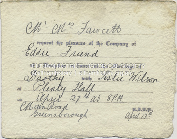
Document - Invitation, Invitation to the wedding reception of Dorothy Fawcett and Leslie Wilson, Plenty Hall, Main Street, Greensborough, April 27, 1940
Invition to Richard Edward Fielding and a friend to attend the wedding reception for Dorothy Fawcett and Leslie Wislon at Plenty Hall, Greensborough on April 27, 1940 Mr - Mrs Fawcett request the pleasure of the Company of Eddie - Friend at a Reception in honour of the Marriage of Dorothy with Leslie Wilson at Plenty Hall on April 27th at 8 P.M Main Road, Greensborough. R.S.V.P. April 13thdorothy may fawcett, greensborough, leslie anzac wilson, main street, plenty hall, reception, richard edward fielding, tom fielding collection, wedding invitation -
 Greensborough Historical Society
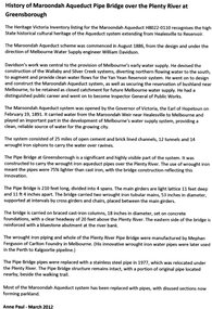
Article, Anne Paul, History of Maroondah Aqueduct Pipe Bridge over the Plenty River at Greensborough, by Anne Paul, 2012_03
The Maroondah Aqueduct pipe bridge, opened in 1891, was an important part of the system carrying water from the Maroondah Reservoir near Healesville to Melbourne. Most of the original system has been replaced by stainless steel pipes, the Greensborough section now running under the Plenty River since 1977. The original pipe bridge can still be seen over the Plenty River at Greensborough.2 p. typescriptaqueduct pipe bridge greensborough, maroondah aqueduct, melbourne water supply, anne paul -
 Eltham District Historical Society Inc
Photograph, Looking south along Para Road at intersection of Alma Street and Lees Road, Lower Plenty, c.July 1967, 1967
Old community hall (long wall with row of windows) and Lower Plenty Kindergarten visible at corner of Glenauburn and Para Roads. Packaged in "Filmpro King Size prints Definitely Better EST. 1918" envelope. Pencil notes: 36 shots $2.87 Eltham Shire J. McD and 19/7/67. Alma Street and Kett Street Lower Plenty c.July 1967.Black and white photographalma street, glenauburn road, carisbrook crescent, lees road, lower plenty, lower plenty kindergarten, para road, houses, streets -
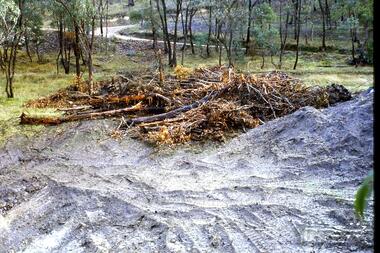 Greensborough Historical Society
Slide - Photograph, John Ramsdale, Headwaters of the Plenty River: Slide 85, 1990s
Photograph shows fallen trees with road in background. This the headwaters of the Plenty River and clearing of timber can cause problems such as erosion.Part of the John Ramsdale collection of slides and audio visual material.Colour photograph scanned from slide.No maker's marks. No caption on slide.plenty river -
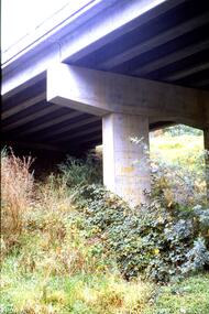 Greensborough Historical Society
Slide - Photograph, John Ramsdale, Greensborough Bypass over Plenty River Drive: Slide 60, 1990s
Photograph shows pylon under bridge or overpass - Greensborough Bypass over Plenty River Drive. Note blackberries on ground.Part of the John Ramsdale collection of slides and audio visual material.Colour photograph scanned from slide.No maker's marks. No caption on slide.greensborough bypass, plenty river drive greensborough -
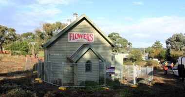 Greensborough Historical Society
Photograph - Digital Image, Marilyn Smith, Former Uniting Church, Plenty, 2018_
The former Uniting Church being prepared for removal due to roadworks in Plenty. The building was most recently used as a florist - Sugabuds.Digital copy of colour photographplenty- places, sugabuds florist, uniting church -
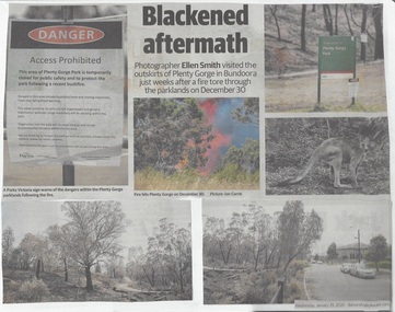 Greensborough Historical Society
Newspaper Clipping, Diamond Valley Leader et al, Scorched Earth: attention turns to recovery plan after devastating Plenty Gorge fire, 29/01/2020
An eerie, blackened landscape remains after a bushfire ripped through more than 40 ha of the Plenty Gorge parklands.News article 2 pages, black text and colour images.plenty gorge park, bushfire -
 Greensborough Historical Society
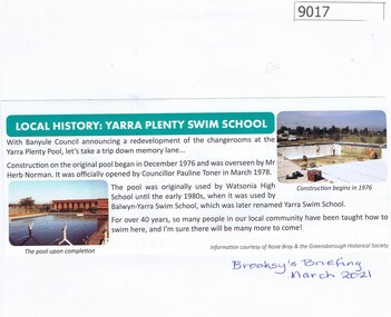
Article - Article, Newsletter, Local History: Yarra Plenty Swim School, 03/2021
Article from Brooksy's Briefing March 2021 about the Yarra Plenty Swim School, with a brief history of he pool.Clipping from Brooksy's Briefing March 2021, text and colour illus.watsonia high school, swimming pools greensborough, yarra swim school -
 Eltham District Historical Society Inc
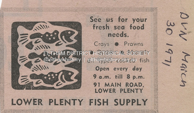
Document - Property Binder, 91 Main Road, Lower Plenty, 1971
Newspaper advertisement: Leader Associated Newspapers, Eltham Centenary Supplement, March 30, 1971 Lower Plenty Fish Supplymain road, property, businesses, lower plenty fish supply, lower plenty -
 City of Moorabbin Historical Society (Operating the Box Cottage Museum)
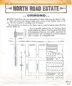
Flyer - North Road Estate, Ormond
At the end of World War One, there was a renewed interest in residential land and a number of estates opened up in the Municipality of Moorabbin.Example of the progress of the Municipality of MoorabbinAdvertising flyer for auction of real estate sales - plan of building blocks for saleNorth Road Estate, Ormond - plan of subdivision.36north road, wicklow st, leinster st, ormond, real estate -
 Ringwood and District Historical Society
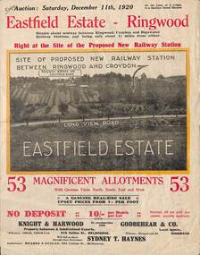
Flyer, Subdivisional Land Auction Sale Brochure, Eastfield Estate, Ringwood, Vic. - 1920
Bi-folded double sided land advertisement for subdivision auction on Saturday, December 11th, 1920, for Eastfield Estate with location map and summary of local facilities and services.Subdivision includes Croydon South streets - Eastfield Road, Long View Road, The Mount, and Pleasant Rise. Local Agent - Godbehear & Co, Phone Ringwood 49. -
 Ringwood and District Historical Society
Flyer, Land Auction Sale Brochure, Proclamation Estate, Ringwood, Victoria - circa 1963
Land sale auction advertisement - Proclamation Estate, Ringwood, with map of subdivision and summary of local features and services. Auction date, Saturday, March 2, (1963?), at 2pm.Subdivision plan includes Maidstone Street, Stanhope Court, Wrights Court, and Watirna Road. (Agents) Blackburn & Lockwood in conjunction with C.E. Carter & Son, 126 Whitehorse Road, Ringwood (Phone) 87 6024. -
 Whitehorse Historical Society Inc.
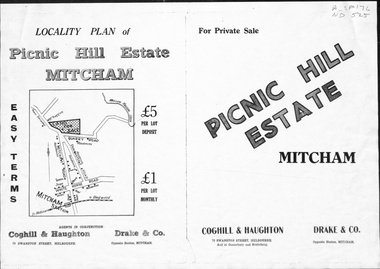
Pamphlet, Picnic Hill Estate, Mitcham, n.d
Photocopy of pamphlet, locality map and plan of 40 home sites on Picnic Hill estate extending from Quarry Road, Mitcham Road and McKeon Road, Mitchamland subdivision, mitcham road, mitcham, quarry road, mckeon road, wooddale grove, rotherwood avenue, cobham road -
 Whitehorse Historical Society Inc.
Pamphlet, Hill 60 Estate, 1/04/1957 12:00:00 AM
Auctioneer's brochure for Hill 60 Estate, Forest Hill.Auctioneer's brochure for Hill 60 Estate, Forest Hill. 64 sites for auction 2.30 pm Saturday 13 April 1957. Agent Frank Fisher & Co.Auctioneer's brochure for Hill 60 Estate, Forest Hill. forest hill, hill 60 estate, forest hill, frank fisher & co, fisher, frank, menin road, nunawading, andrew street, nunawading, fisher street, nunawading, will street, nunawading, jocelyn court, nunawading, shady grove, nunawading -
 Whitehorse Historical Society Inc.
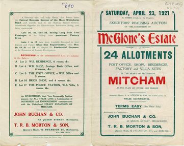
Document, McGlone's Estate, 1/04/1921 12:00:00 AM
Brochure on McGlone's Estate, Mitcham. auction of 24 allotments, April 1921.Brochure on McGlone's Estate, Mitcham. auction of 24 allotments, April 1921. Bordered by Station Street, Whitehorse Road, McGlone Street and Mitcham railway line and stationBrochure on McGlone's Estate, Mitcham. auction of 24 allotments, April 1921.land sales, auctions, mcglone, john, elizabeth, mitcham post office, mitcham police station, station street, mitcham, mcglone street, whitehorse road -
Whitehorse Historical Society Inc.
Document - Correspondence, Walker Estate, 1997-1998
Two folders of correspondence, submissions and history relating to the Walker Estate, Mitcham 1997-1998 including slides and illustrations with examples of Australian Tesselated Tile Company's products.land subdivision, walker estate, australian tesselated tile co pty. ltd., national trust of australia (victoria), city of whitehorse, kelly, john, heritage victoria, kelly, claire, benares street, mitcham -
Whitehorse Historical Society Inc.
Booklet - photocopy, Central Hill Estate, 2/05/1953 12:00:00 AM
Copies of a sale brochure for the auction of 55 sites on the subdivision Central Hill Estate, Mitcham.Copies of a sale brochure for the auction of 55 sites on the subdivision Central Hill Estate, Mitcham. Agents Edward Haughton Pty Ltd and Stanley R. Penny & Co.Copies of a sale brochure for the auction of 55 sites on the subdivision Central Hill Estate, Mitcham.central hill estate, mitcham, australian tesselated tile co pty ltd, rooks road, mitcham, grace street, mitcham, gibson street, mitcham, howard street, mitcham, edward haughton pty ltd, stanley r. penny & co. -
 Kew Historical Society Inc
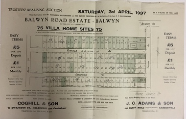
Plan - Subdivision Plan, Balwyn Road Estate, Balwyn (1937), 1937
Historic subdivision in Balwyn, VictoriaSubdivision Plan of Balwyn Road Estate (Balwyn). Held in April 1937, the auction included 102 lots for sale in Yongala Avenue, Young Street, and Balwyn RoadInscriptions on individual lots by agentsubdivision plans - balwyn (vic), balwyn road estate - balwyn -
 Kew Historical Society Inc
Plan - Subdivision Plan, Kew Golf Links Estate, 1936, 1936
The Kew Golf Links Estate was a major subdivision in North Kew. It derived its title due to the land being previously occupied by the Kew Golf Club, which transferred its course to a number of locations before occupying its current site. The Plan advertises 180 choice home sites. The street names are somewhat different today as those on the map are named after the proposed Kodak Factory to be built on the site. The subdivision of the Kew Golf Links Estate was a major subdivision of farmland in Kew. The site was at one stage designated for industrial development and the building of a new Kodak factory. The decision by Council to oppose the redevelopment makes the beginning of the period when all industrial development was banned in Kew.Monochrome printed, folded subdivision plan for the Kew Golf Links Estate, to be auctioned on 7 November 1936. Streets named include: Carnegie Avenue, Willsmere Road, Kilby Boulevarde, Kodak Avenue, Coleman Avenue, Beresford Avenue, McConchie Avenue, Cole Avenue, White Avenue, Baker Avenue, Spruzen Avenue, Tanner Avenue, Ratten Avenue, Mathers Avenue, Railway Avenue, Sutherland Avenue, and Belford Road. The position of the Yarra River and a large Drainage Reserve are marked on the plan. Lots for sale are numbered. Existing buildings are designated with a square.subdivision plans - kew (vic), kodak factory - kew (vic) -
 Eltham District Historical Society Inc
Slide - Photograph, Russell Yeoman, Para Road / Carter Street Bridge over the Plenty River, Briar Hill, c.Jul 1969
Bridge over the Plenty River at Briar Hill before widening and alterations. The Plenty River at Briar Hill represented the boundary between the Shire of Eltham and the Shire of Diamond Valley. The bridge was known as the Carter Street Bridge as prior to 1969 Para Road, Briar Hill became Carter Street, Greensborough across the river. It was at this time that the name Para Road was continued and replaced Carter Street.35mm colour positive transparency blue Agfacolour Service plastic mount1969-07, briar hill, carter street bridge, para road, para road bridge, shire of diamond valley, shire of eltham, bridge, plenty river, shire of eltham pioneers photograph collection -
 Greensborough Historical Society
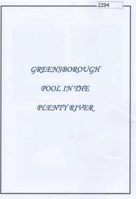
Folder (article and photographs), Greensborough Pool in the Plenty River / compiled by Marilyn Smith, 1937o
Society member Marilyn Smith has compiled a collection of historic articles from local newspapers, historic and modern photographs of the swimming pool in the Plenty River Greensborough, opened in 1937. The Pool is still visible from the Main Street bridge and present day photographs are also included. A short story by Gary Partington tells of his memories of the Plenty River as he was growing up.An historical view of the Greensborough pool in the Plenty River.Folder with pink plastic cover. 12 pages of text and photographs.plenty river, greensborough swimming pool, marilyn smith, gary partington -
 Eltham District Historical Society Inc
Negative - Photograph, Russell Yeoman, Para Road / Carter Street Bridge over the Plenty River, Briar Hill, c.Jul. 1969
Bridge over the Plenty River at Briar Hill before widening and alterations. The Plenty River at Briar Hill represented the boundary between the Shire of Eltham and the Shire of Diamond Valley. The bridge was known as the Carter Street Bridge as prior to 1969 Para Road, Briar Hill became Carter Street, Greensborough across the river. It was at this time that the name Para Road was continued and replaced Carter Street.This photo forms part of a collection of photographs gathered by the Shire of Eltham for their centenary project book,"Pioneers and Painters: 100 years of the Shire of Eltham" by Alan Marshall (1971). The collection of over 500 images is held in partnership between Eltham District Historical Society and Yarra Plenty Regional Library (Eltham Library) and is now formally known as the 'The Shire of Eltham Pioneers Photograph Collection.' It is significant in being the first community sourced collection representing the places and people of the Shire's first one hundred years.Digital image 35 mm B&W negativeshire of eltham pioneers photograph collection, briar hill, 1969-07, bridge, carter street bridge, para road, para road bridge, plenty river, shire of diamond valley, shire of eltham -
 Greensborough Historical Society
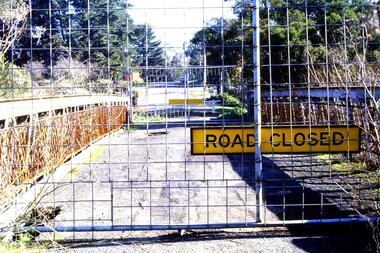
Slide - Photograph, John Ramsdale, Old bridge at Lower Plenty under reconstruction: Slide 83, 1990s
Photograph shows a road construction area with "Road Closed" sign and temporary fencing. This is the old bridge at Lower Plenty under reconstruction.Part of the John Ramsdale collection of slides and audio visual material.Colour photograph scanned from slide.No maker's marks. No caption on slide.old lower plenty bridge, lower plenty bridge -
 Eltham District Historical Society Inc
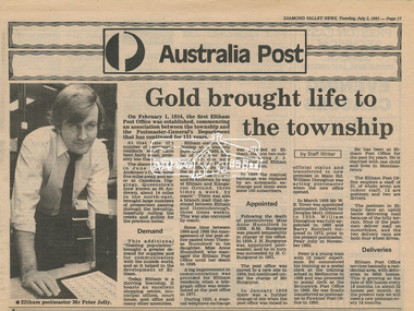
Newsclipping, Diamond Valley News, Gold brought life to the township, Diamond Valley News, 2 July 1985, p17, 2 Jul 1985
A history of Eltham Post Office. Australia Post: Gold brought life to the township - Diamond Valley News, Tuesday July 2, 1985, p17 On February 1, 1854, the first Eltham Post Office was established, commencing an association between the township and the Postmaster-General's Department that has continued for 131 years. At that time, the number of permanent residents would have been fairly small, probably less than 200. The discovery of gold in June 1851, at Anderson’s Creek, some five miles away, and later at Caledonia Diggings, Queenstown (now known as St Andrews), about 14 miles to the north-east, brought large numbers of prospectors passing through the township, hopefully culling the creeks and gullies for the precious metal. This additional "floating population" brought a greater demand for supplies and for communication with the outside world, and so it helped in the development of Eltham. Today, Eltham is a thriving township. It boasts an excellent shopping centre, municipal offices, court house. post office and many other amenities. Eltham continued to develop at a leisurely pace. During 1860, a total of just over 8000 postal articles were handled at the Eltham Post Office. By 1862, the mail route was "to and from Melbourne by way of Eltham and Kangaroo Ground, three times a week, by coach". There was also a branch mail that operated between Eltham and Greensborough, three times weekly. This was also conveyed by coach. Some time between 1864 and 1868 the management of the post office passed from Thomas Hunniford to his daughter, Miss Anne Hunniford, who managed the Eltham Post Office until her death in 1928. A big improvement in communication was provided for Eltham residents when a telegraph office was established at the post office in 1877. During 1923 a manual telephone exchange was provided at Eltham, the first two subscribers being J.J. O’Connor and Eltham Police Station. In 1949 the manual exchange was replaced by an automatic exchange and there were some 150 subscribers. Following the death of postmistress Miss Anne Hunniford in 1928, B.M. Burgoyne was placed temporarily in charge of the office. In 1929, J. N. Burgoyne was appointed postmaster, and he in turn was succeeded by H. C. Burgoyne in 1951. The post office was moved to a new site in 1954, but continued under the charge of Mr Burgoyne. In January 1958 there was a further change of site when the post office was raised to official status and transferred to new premises in Main Rd. William Donoghue was acting postmaster when the new office was opened. In March 1958 Mr W.E. Tovey was appointed postmaster, followed by Douglas McG. Gilmour in 1959. William Donoghue was fully appointed in 1966 and Barry Reichelt followed in 1973, prior to the present postmaster, Peter Jolly in November 1982. Peter is a young man with 18 years' experience. He commenced his training as a postal clerk at the training school in Melbourne in 1968 and was promoted to postal clerk at the Brunswick Post Office in 1969. He was finally transferred as postmaster to Fawkner Post Office in 1980. He has been at Eltham Post Office for the past 2½ years. He is married with one child and lives in Montmorency. The Eltham Post Office employs a staff of 21, of whom seven are indoor staff, 12 are postmen and two are drivers. The postmen in Eltham have an uphill battle delivering mail because of the hilly terrain. Nine of the postmen deliver mail on motorbikes, and the two delivery vans are both four wheel drives. Eltham Post Office services basically a residential area, with deliveries to 5600 homes. This is growing at the rate of 600 homes every 18 months, i.e. about 32 homes per month. At the present rate we will need a new postman every 18 months.Digital file only - Digitised by EDHS from a scrapbook on loan from Beryl Bradbury (nee Stokes), daughter of Frank Stokes.anderson's creek, anne hunniford, b.m. burgoyne, barry reichelt, beryl bradbury (nee stokes) collection, eltham police station, eltham post office, eltham post office history, gold, h.c. burgoyne, j.j. o'connor, j.n. burgoyne, peter jolly, postmaster, telephone exchange, thomas hunniford, w.e. tovey, william donoghue