Showing 2794 items matching "robert street"
-
 Port Melbourne Historical & Preservation Society
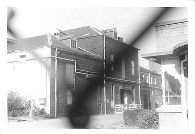
Photograph - Harper's Buildings, Port Melbourne, Janet and Allen Walsh, Janet and Allen Walsh, Harpers building Beach St, 1973
Shot in 1973 with particular interest in architectureSome Harper's factory buildings on Beach St. 1973Identified and dated on back in inkbuilt environment - commercial, built environment - industrial, robert harper & co ltd -
 Port Melbourne Historical & Preservation Society
Letter - Letters of appreciation of Port Melbourne Cr F R WINDUSS, City of Port Melbourne, 1978 - 1989
Councillor F R WINDUSS served 5 terms as MayorFramed letters of appreciation of F R WINDUSS from the City of Port Melbourne (.01) for 15 years of service 19.9.1989 (.02) at the conclusion of his 5th term as Mayor 8.10.1985 (.03) for terms of office 1976/1977 and 1977/1978, 29.8.1978 (.04) for term of office 1980/1981, 25.8.1981Letters bear the Common Seal of the City of Port Melbourne and are signed by Mayor, Councillor and Town Clerklocal government - city of port melbourne, frederick robert winduss -
Port Melbourne Historical & Preservation Society
Book - Minutes, Electric Light Committee, Town of Port Melbourne, 1912 - 1916
W H Ashman - Electrical EngineerMinutes of Electric Lighting Committee from 05 Mar 1912 - 08 Feb 1916, following Port Melbourne Council's decision of 23 Jan 1912 to consider an electric light and power scheme for the town.local government - town of port melbourne, melbourne harbor trust - port of melbourne authority, joseph hayes morris, james peter crichton, w h ashman, owen sinclair, george samuel walter, william howe, arthur leaverack page, richard henry gill, thomas smith, robert harper & co ltd, albert tucker -
Port Melbourne Historical & Preservation Society
Book - Pecuniary interest of Port Melbourne Councillors, 1970
Book of notices of pecuniary interest by Port Melbourne Councillors c1970local government - city of port melbourne, theodore thomas (tom) buckingham, henry melville fennell, james malcolm (jim) mitchell, barry 'bomber' mitchell, john william (jack) woodruff, frederick robert winduss, perce mcguire white, perce white, archibald (arch) todd, gordon lockhart edwards -
Port Melbourne Historical & Preservation Society
Document - Newsletter, South Melbourne/Port Melbourne Historical and Preservation Society, Sep 1984
Given to Society by Wendy LOWENSTEIN in 1998. The SMPMH&PS existed between the 1970s and approx. 1990.One of three bulletins of the South Melbourne/Port Melbourne Historical & Preservation Society: September 1984. 16 unbound pages, A5, maize coveremerald hill, south melbourne, societies clubs unions and other organisations, town planning, south melbourne - port melbourne historical & preservation society, kay rowan, adair bunnett, les hill, talbot hill, robert baker, anne fahey, flo burke, national trust of victoria -
Port Melbourne Historical & Preservation Society
Document - Newsletter, South Melbourne/Port Melbourne Historical and Preservation Society, Sep 1984
Given to Society by Wendy LOWENSTEIN in 1998. The SMPMH&PS existed between the 1970s and approx. 1990.One of three Bulletins of the South Melbourne/Port Melbourne Historical & Preservation Society: October 1984. 16 unbound pages, A5, maize coveremerald hill, south melbourne, societies clubs unions and other organisations, town planning, south melbourne - port melbourne historical & preservation society, kay rowan, adair bunnett, les hill, talbot hill, robert baker, anne fahey, flo burke, national trust of victoria, dot wharrie -
Port Melbourne Historical & Preservation Society
Document - Newsletter, South Melbourne/Port Melbourne Historical and Preservation Society, Historical News, Sep 1981
Given to Society by Talbot Hill in 2003. The SMPMH&PS existed between the 1970s and approx. 1990.'Historical News'- One of three bulletins of the South Melbourne/Port Melbourne Historical & Preservation Society: Volume 3 No. 1, September 1981. 20 pages, A4, beige coveremerald hill, south melbourne, societies clubs unions and other organisations, town planning, south melbourne-port melbourne historical & preservation society, john robert buxton, william parton buckhurst -
Port Melbourne Historical & Preservation Society
Programme, St Joseph's Parish - Reopening of the Church, Sep 1999
Church and grounds were renovated in 1999, completed 4th September in time for the reopening service the following day. Hugh BROWN, Parish PriestProgram of service for the reopening of St Joseph's Catholic Church 5 Sept 1999. 16pp, cover cream and green with full colour representation of stained glass windowreligion - roman catholic church (st josephs), celebrations fetes and exhibitions, jim power, hugh brown, fred elliott, kay elliott, robert winduss, dianne drury, bill blackmore, jacqui o'callaghan, cellia carmody, joseph lynch, sally o'shannessy, norma sheehan, charlotte winduss, frances moore, paula elliot, ed mcdonnell, fiona mcdonnell, scott mcdonnell, brendan o'donnell, kate ryan, kate cleaves -
Port Melbourne Historical & Preservation Society
Document - Bulletin, St Joseph's Parish - Reopening of the Church, Sep 1999
Church and grounds were renovated in 1999, completed 4th September in time for the reopening service the following days. Hugh BROWN, Parish PriestChurch bulletin for the reopening of St Joseph's Catholic Church 5 Sept 1999. 4pp, light green insert in programreligion - roman catholic church (st josephs), celebrations fetes and exhibitions, jim power, hugh brown, fred elliott, kay elliott, robert winduss, dianne drury, bill blackmore, jacqui o'callaghan, cellia carmody, joseph lynch, sally o'shannessy, norma sheehan, charlotte winduss, frances moore, paula elliot, ed mcdonnell, fiona mcdonnell, scott mcdonnell, brendan o'donnell, kate ryan, kate cleaves -
Port Melbourne Historical & Preservation Society
Card - Cigarette, Bob FORBES, PMFC player, Rose Stereograph Co, c. 1922
Football card c1922 featuring PMFC player Bob FORBES and advertising Magpie Cigarettes (J.J.Schub Tobacco Co.) Mounted on card along with items 1531.01-.07sport - australian rules football, port melbourne football club, pmfc, robert (bob) forbes -
Port Melbourne Historical & Preservation Society
Book, Richard Broome, Remembering Melbourne 1850-1960, 2016
"Remembering Melbourne 1850-1960". Large red covered book with black and white dust cover featuring panoramic view of Princes Bridge looking North. Photographs and text covering Melbourne CBD and 20 suburbs including Port Melbourne.Royal Historical Society Victoria (RHSV) bookplate signed by Don Garden and Richard Broome.built environment, business and traders, centenary bridge, piers and wharves - railway pier, sport, industry, religion - anglican (holy trinity), swallow & ariell ltd, sandridge lagoon, melbourne air service, joshua brothers distillery, robert harper & co ltd, faram brothers hardware, j kitchen & sons pty ltd, courthouse, police station, north port oval, missions to seamen, commonwealth engine works -
Port Melbourne Historical & Preservation Society
Book, Robert La Nauze, Engineer to marvellous Melbourne - The Life and Times of William Thwaites, 2011
Engineer to marvellous melbourne - The Life and Times of William Thwaites Second edition by Robert D LA NAUZE (signed). Paperback produced by Melbourne Water to tell the story of the extraordinary young engineer who oversaw the sewering of Melbourne in the 1880s and 90s. Chrome yellow with sepia photo of aquaduct project 1890sSigned by author on title page. Archival PMHPS Stamp 1st page, also donor name in inkengineering - board of works, built environment - civic, william thwaites, george thwaites snr, elizabeth thwaites, george thwaites jnr, melbourne and metropolitan board of works, mmbw, all england eleven hotel, robert d la nauze -
Port Melbourne Historical & Preservation Society
Clothing - Wedding dress, Alice Mott Hegarty, 1958
Worn by Barbara GARDINER (nee HEGARTY) at her wedding to Robert GARDINER, at Holy Trinity Church, Port Melbourne on November 1 1958. The dress was made by Barbara's mother, Alice HEGARTY (nee MOTT) and later requisitioned for a party dress for a friend.Wedding dress of ivory brocaded satin, long sleeves with pointed ends, piped at waist and hem, short train with loop for wristcelebrations fetes and exhibitions, domestic life, costume, handcrafts, weddings, barbara gardiner nee hegarty, alice hegarty nee mott, robert (bob) gardiner -
Port Melbourne Historical & Preservation Society
Clothing - Wedding dress, Barbara GARDINER, Alice Mott Hegarty, 1958
Worn by Barbara GARDINER (nee HEGARTY) at her wedding to Robert GARDINER, at Holy Trinity Church, Port Melbourne on November 1 1958. The dress was made by Barbara's mother, Alice HEGARTY (nee MOTT) and later requisitioned for a party dress for a friend.Barbara GARDINER wedding. Half petticoat ivory brocade satin waist section, plain satin underskirt and net overskirt with ribbon roses decoration, and blue ribbon bow. Petticoat is a full circlecelebrations fetes and exhibitions, domestic life, costume, handcrafts, weddings, barbara gardiner nee hegarty, alice hegarty nee mott, robert (bob) gardiner -
Port Melbourne Historical & Preservation Society
Clothing - Wedding dress (section of train), Barbara GARDINER, Alice Mott Hegarty, 1958
Worn by Barbara GARDINER (nee HEGARTY) at her wedding to Robert GARDINER, at Holy Trinity Church, Port Melbourne on November 1 1958. The dress was made by Barbara's mother, Alice HEGARTY (nee MOTT) and later requisitioned for a party dress for a friend.Barbara GARDINER wedding. Section of original long train.celebrations fetes and exhibitions, domestic life, costume, handcrafts, weddings, barbara gardiner nee hegarty, alice hegarty nee mott, robert (bob) gardiner -
Port Melbourne Historical & Preservation Society
Clothing - Wedding dress (roses, bows, etc), Barbara GARDINER, Alice Mott Hegarty, 1958
Worn by Barbara GARDINER nee HEGARTY at her wedding to Robert GARDINER, at Holy Trinity Church, Port Melbourne on November 1 1958. The dress was made by Barbara's mother, Alice HEGARTY (nee MOTT) and later requisitioned for a party dress for a friend.Barbara GARDINER wedding. Several roses, bow and pieces made of the ivory brocaded satincelebrations fetes and exhibitions, domestic life, costume, handcrafts, weddings, barbara gardiner nee hegarty, alice hegarty nee mott, robert (bob) gardiner -
Port Melbourne Historical & Preservation Society
Document - Wedding dress pattern, Barbara GARDINER, Butterick Pattern Service, 1958
Worn by Barbara GARDINER nee HEGARTY at her wedding to Robert GARDINER, at Holy Trinity Church, Port Melbourne on November 1 1958. The dress was made by Barbara's mother, Alice HEGARTY (nee MOTT) and later requisitioned for a party dress for a friend.Barbara GARDINER wedding. Butterick paper dress pattern from which the wedding dress was madecelebrations fetes and exhibitions, domestic life, costume, handcrafts, weddings, barbara gardiner nee hegarty, alice hegarty nee mott, robert (bob) gardiner -
Port Melbourne Historical & Preservation Society
Accessory - Wedding accessories, Good luck charm, Family and friends of Barbara Gardiner, 1958
Bridal good luck charms made by family and friends to be worn by Barbara GARDINER nee HEGARTY at her wedding. See 4007 for full detail.Seven bridal good luck charms with ribbon loops, to be worn on bride's wrist. Heart shaped charm, white satin over card, with white wax flowers, white bow and braided trim. Handwritten message on back in pencelebrations fetes and exhibitions, domestic life, costume, handcrafts, weddings, barbara gardiner nee hegarty, alice hegarty nee mott, robert (bob) gardiner -
Port Melbourne Historical & Preservation Society
Accessory - Wedding accessories, Good luck charm, Family and friends of Barbara Gardiner, 1958
Bridal good luck charms made by family and friends to be worn by Barbara GARDINER nee HEGARTY at her wedding. See 4007 for full detail.Seven bridal good luck charms with ribbon loops, to be worn on bride's wrist. Shoe shaped charm, white satin over card, with white wax flowers, pink bows and pink trim.celebrations fetes and exhibitions, domestic life, costume, handcrafts, weddings, barbara gardiner nee hegarty, alice hegarty nee mott, robert (bob) gardiner -
Port Melbourne Historical & Preservation Society
Accessory - Wedding accessories, Good luck charm, Family and friends of Barbara Gardiner, 1958
Bridal good luck charms made by family and friends to be worn by Barbara GARDINER nee HEGARTY at her wedding. See 4007 for full detail.Seven bridal good luck charms with ribbon loops, to be worn on bride's wrist. Horseshoe shaped charm, runched blue and white satin over card, with white wax flowerscelebrations fetes and exhibitions, domestic life, costume, handcrafts, weddings, barbara gardiner nee hegarty, alice hegarty nee mott, robert (bob) gardiner -
Port Melbourne Historical & Preservation Society
Accessory - Wedding accessories, Good luck charm, Family and friends of Barbara Gardiner, 1958
Bridal good luck charms made by family and friends to be worn by Barbara GARDINER nee HEGARTY at her wedding. See 4007 for full detail.Seven bridal good luck charms with ribbon loops, to be worn on bride's wrist. Horseshoe shaped charm, runched white satin over card, with white wax flowerscelebrations fetes and exhibitions, domestic life, costume, handcrafts, weddings, barbara gardiner nee hegarty, alice hegarty nee mott, robert (bob) gardiner -
Port Melbourne Historical & Preservation Society
Accessory - Wedding accessories, Good luck charm, Family and friends of Barbara Gardiner, 1958
Bridal good luck charms made by family and friends to be worn by Barbara GARDINER nee HEGARTY at her wedding. See 4007 for full detail.Seven bridal good luck charms with ribbon loops, to be worn on bride's wrist. Horseshoe shaped charm, white satin over card, wrapped with brown patterned ribbon, with blue ribbon and silver foil leaves.celebrations fetes and exhibitions, domestic life, costume, handcrafts, weddings, barbara gardiner nee hegarty, alice hegarty nee mott, robert (bob) gardiner -
Port Melbourne Historical & Preservation Society
Accessory - Wedding accessories, Good luck charm, Family and friends of Barbara Gardiner, 1958
Bridal good luck charms made by family and friends to be worn by Barbara GARDINER nee HEGARTY at her wedding. See 4007 for full detail.Seven bridal good luck charms with ribbon loops, to be worn on bride's wrist. Horseshoe shaped charm, white flock with white wax flowerscelebrations fetes and exhibitions, domestic life, costume, handcrafts, weddings, barbara gardiner nee hegarty, alice hegarty nee mott, robert (bob) gardiner -
Port Melbourne Historical & Preservation Society
Accessory - Wedding accessories, Good luck charm, Family and friends of Barbara Gardiner, 1958
Bridal good luck charms made by family and friends to be worn by Barbara GARDINER nee HEGARTY at her wedding. See 4007 for full detail.Seven bridal good luck charms with ribbon loops, to be worn on bride's wrist. Shoe shaped charm, white satin over card with white wax flowers, white bow and white braided trim. Handwritten on back in pen" All our love, Auintie Maya and Uncle Ernie"celebrations fetes and exhibitions, domestic life, costume, handcrafts, weddings, barbara gardiner nee hegarty, alice hegarty nee mott, robert (bob) gardiner -
 Port Melbourne Historical & Preservation Society
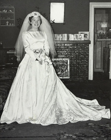
Photograph - Barbara HEGARTY at home before her wedding, 1 Nov 1958
Barbara GARDINER (nee HEGARTY) married Robert GARDINER, at Holy Trinity Church, Port Melbourne on November 1 1958. The dress was made by Barbara's mother, Alice HEGARTY (nee MOTT). The bridesmaids dresses were made by Margaret Conn who was one of the bridesmaids.B&W photograph of Barbara HEGARTY at home before her wedding to Bob GARDINER.weddings, celebrations fetes and exhibitions, domestic life, religion - anglican (holy trinity), robert (bob) gardiner, barbara gardiner nee hegarty -
Port Melbourne Historical & Preservation Society
Book, John J Shillinglaw, "Historical records of Port Phillip", 1972
"Historical records of Port Phillip - the first annals of the Colony of Victoria" edited by John J Shillinglaw, first published 1878melbourne, history, charles grimes, david collins, robert kropwood, john shillinglaw -
Port Melbourne Historical & Preservation Society
Book, 321 Imagined Settlement, May 2018
"321 Imagined Settlement" Book with sketch of 321 Esplanade East on bottom half and black at top with white title and authors name in red."To the members of the PMH&PS. Thanks for all of your assistance with my book. Ray Jelley."built environment - domestic, families, ray jelley, esplanade east, john philipson, william basford, hugh trainor, mathias larkin, joseph overend, janet overend, john bichard grut, john lumsden, ellen lumsden, william stapleton, george burrows, william gedge, david kelly, mrs e e watkins, robert bryant, emily sanderson, marilyn johnson, lora starling -
Port Melbourne Historical & Preservation Society
Book, Michael McKernan, Victoria at War 1914-1918, 2014
"Victoria at War 1914-1918" Records the achievements of the State's soldiers, doctors, nurses and their families 1914-18 Brown covered book with photo of marching soldiers on front cover. war - world war i, armed services - navy, armed services - army, armed services - air force, returned services league, rsl, michael mckernan, john monash, albert (bert) jacka, harold elliott, keith murdoch, angus whitelaw, kenneth whitelaw, robert whitelaw, lionel whitelaw, annie whitelaw, ivan cecil whitelaw, donald whitelaw -
Port Melbourne Historical & Preservation Society
Document - Political Advertisements, 2016 City of Port Phillip election, 2016
Candidates election material for 2016 City of Port Phillip collections; Ogy SIMIC; Bernadene VOSS; Richard ROBERTS; Rohan CRESP; Marcus PEARL; Tim BAXTER; Katherine COPSEY. Assorted flyers and pamphlets . 11 in total.local government - city of port phillip, rohan cresp, bernadene voss, richard roberts, ogy simic, tim baxter, katherine copsey, marcus pearl -
Port Melbourne Historical & Preservation Society
Exhibition Catalogue, "Sportstuff", 2001
No final copy of this catalogue exists, but this draft indicates the level of loans from over a dozen local sporting organisations plushistorical collections and researchon past events and organisations. Rare trophies, pennants and medals (including a Brownlow medal for Peter BEDFORD)required security precautions.Six page draft of catalogue for 2001 "Back to Port" 2 day exhibition "Sportstuff". Held at the Liardet Street Freemason's Hall during Port Melbourne Community Festival, in conjunction with all Port Melbourne sporting clubsAlteration to document are written in inkross street rovers, watson's baths, sport - cricket, sport - baseball, sport - lawn bowls, sport - football, lifesaving, sport - shooting, sport - soccer, sport - tennis, sport - trugo, sailing, sport - quoits, sport - cycling, sport - basketball, sport - boxing, sport - golf, sport - gymnastics, sport - athletics, port melbourne cricket ground, j l murphy reserve, railway united football club, victorian sunday football league, port melbourne colts football club, peggy howard nee antonio, bill payne, john may, john kosinduss, fred coy, jimmy james, ken linnett, tony bogdanoff, tommy lahiff, tony cannatelli, graeme anderson, ted freyer, charles mcleod, james kelly, robert mcleod, reginald earle, william (bill) tilley, j kitchen & sons pty ltd, eli 'dick' edwards, ron bedford, peter bedford, jim penaluna, david holt, bill earle, percy may, jimmy drew, chris raeburn, clyde holding, william (bill) hegarty, walter charles pont, frank gomez, tony stewart, john w stewart, ron stranks, wilbraham frederick evelyn liardet, edward c crockford, town clerks, sydney sims anderson, sea bathing