Showing 20770 items matching "time-allotment"
-
 Port Melbourne Historical & Preservation Society
Photograph - Fire at Princes Pier, Port Melbourne, Cameron Oglebury, 15 Aug 1996
Cameron Oglebury of Clark Street was awakened the night the pier burned, went to the end of the street and took this time exposure, which he gave to Ron Laing in October 2000 to be handed to the Society.Colour snapshot of Princes Pier on fire, taken from a distance (Clark Street). Time exposure, a bit blurry. 15 August 1996'Princes Pier Burning taken by Cameron Ogleby' in ink on backpiers and wharves - princes pier, fire and fire services, cameron oglebury -
 Bendigo Historical Society Inc.
Document - H.A. & S.R. WILKINSON COLLECTION: CONTRACT OF SALE
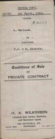
Conditions of sale by private contract dated 1st March, 1944 between A. Wallace (seller) and R.J. & E. Shields (buyer) for land situate in Ellis Street, Kennington containing six acres being described in certificate of title volume 4983 folio 995671 section H and being Crown allotments 529,529A, 529B. Crown grant volume 6111 folio 1222194, crown allotments 530, 530A section H. Crown grant volume 6307 folio 1261328, Crown allotment 529F section H. Crown grant volume 6307 folio 1261329, Crown allotment 529C section H. Crown grant volume 6307 folio 1261293, crown allotment 529D section H. Crown grant volume 6307 folio 1261294 crown allotment 529E section H. Together with 6-roomed weatherboard dwelling and all sundry. Price 1,300 pounds.organization, business, h.a. & s.r wilkinson real estate -
 Whitehorse Historical Society Inc.
Photograph, Rob's Cycles Shop, 4/09/1999 12:00:00 AM
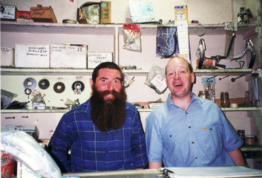
Photo of Noel Shone (full time assistant) and part time assistant behind counter in shop.robinson, george, rob's cycle and sports, blackburn road, blackburn, no.12, shone, noel -
 Ringwood and District Historical Society
Flyer, Land Sale Brochure, Glamis Park Estate (Wantirna, Vic.) - 1959
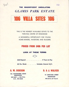
Street name Carnarvon Avenue on the subdivision plan became Selkirk Avenue at some stage during or subsequent to development of the Estate.Bi-folded advertisement for sale of residential allotments, including summary of subdivision features and local facilities.Subdivision includes Wantirna streets - Wantirna Road, Carnarvon Avenue, Inchcape Avenue, St Thomas Avenue, St Davids Drive, Dudley Avenue, Angus Avenue. Agents - A.W. Dickson, 136 Whitehorse Road, Ringwood, Telephone WU 6007, WU 7016, A.H. WU 6868. D. & J. Walker, 18 Junction Street, Ringwood, Telephone WU 6516 (all hours). -
 Federation University Historical Collection
Plan, Creswick, County of Talbot
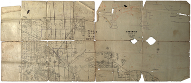
This plan is associated with former Ballarat School of Mines Student Richard Squire (1875-1876). Gift of the Squire Family, 2014 Plan showing allotments in Creswick, County of Talbot. The plan is in a number of pieces with some sections missing.creswick, creswick creek, spring hill, sarah paterson, lehman, mullins, spittle, squire, richard squire -
 Bendigo Historical Society Inc.
Map - JACK FLYNN COLLECTION: ARCHDALE, 15/01/1936
Map: Parish of Archdale, County of Gladstone. Parish plan. The Allotments have been coloured in with pencil.By Authority H.J. Green, Government Printer Melbourne. Drawn and Reproduced at the Dept, of Lands and Survey, Melbourne, Victoria. 15/01/36map, gladstone, parish plan, archdale , gladstone -
Bendigo Historical Society Inc.
Map - HUNTLY ALLOTMENTS, No date visible
Map; Huntly Allotments, County of Bendigo. Parish plan (number 289 in map cupboard 1)map, bendigo, allotments, huntly allotments -
 Whitehorse Historical Society Inc.
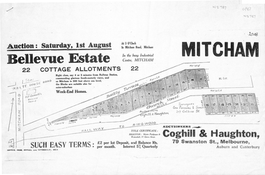
Pamphlet, Bellevue Estate, ca 1927
Land sale of 22 allotments at Mitcham ca 1927 bounded by Barkly Terrace and Church Street.land sales, barkly terrace, mitcham, church street, bellevue estate, coghill & haughton -
 Ringwood and District Historical Society
Map - Plan of Subdivision, Part of Crown Section 24, Parish of Warrandyte, County of Evelyn - undated, circa 1951
Survey map of residential allotments in Milne Road, east of Berringa Road, Park Orchards, Victoria. -
 Warrnambool and District Historical Society Inc.
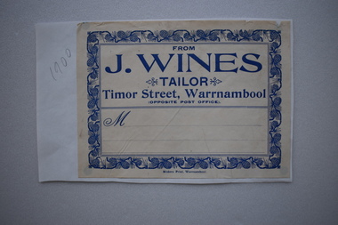
Label, J.Wines Tailor
We have only one reference to J. Wines as operating a tailoring business in Timor Street opposite the old Post Office in 1909 but the label dates from about 1900.This label is of some significance as it is our only memento of this early 20th century tailoring business in Warrnambool .Buff coloured rectangular paper label with blue text and decorative border of pine cones and leaves attached to a white piece of paper.FROM J.WINES .TAILOR Timor Street, Warrnambool OPPOSITE POST OFFICE M Modern Print, Warrnamboolj. wines, tailor -
 Kew Historical Society Inc
Plan - Subdivision Plan, High Street, Kew, 1920-1935
Pru Sanderson, in her groundbreaking ‘City of Kew Urban Conservation Study : Volume 2 - Development History’ (1988), summarised the periods of urban development and subdivisions of land in Kew. The periods that she identified included 1845-1880, 1880-1893, 1893-1921, 1921-1933, 1933-1943, and Post-War Development. These periods were selected as they represented periods of rapid growth or decline in urban development. An obvious starting point for Sanderson’s groupings involved population growth and the associated economic cycles. These cycles also highlighted urban expansion onto land that was predominantly rural, although in other cases it represented the decline and breakup of large estates. A number of the plans in the Kew Historical Society’s collection can also be found in other collections, such as those of the State Library of Victoria and the Boroondara Library Service. A number are however unique to the collection.The Kew Historical Society collection includes almost 100 subdivision plans pertaining to suburbs of the City of Melbourne. Most of these are of Kew, Kew East or Studley Park, although a smaller number are plans of Camberwell, Deepdene, Balwyn and Hawthorn. It is believed that the majority of the plans were gifted to the Society by persons connected with the real estate firm - J. R. Mathers and McMillan, 136 Cotham Road, Kew. The Plans in the collection are rarely in pristine form, being working plans on which the agent would write notes and record lots sold and the prices of these. The subdivision plans are historically significant examples of the growth of urban Melbourne from the beginning of the 20th Century up until the 1980s. A number of the plans are double-sided and often include a photograph on the reverse. A number of the latter are by noted photographers such as J.E. Barnes.A roughly drawn and faded actual or projected subdivision of a parcel of land bordering on High and Mary Streets. The plan shows five allotments facing High Street and at their rear, another allotment facing Mary Street. In 1906, when the Board of Works surveyors completed Detail Plan 1589, the allotment in Mary Street is shown to include a building. The section of land attached to this building is shown to be undeveloped, thus making a further subdivision possible.subdivision plans - kew, high street -- kew (vic.), mary street -- kew (vic.) -
 Warrnambool and District Historical Society Inc.
Bottle, S Rowley, Late 19th century
This bottle was known as a torpedo bottle. As the bottle had to lie on its side the soda was kept in contact with the cork and stopped the cork from shrinking and causing loss of pressure. This bottle comes from the Warrnambool aerated waters factory of John Searle Rowley (1837-1893). John Rowley, born in England, came to Australia in 1856 and in 1865 he opened a branch of the Geelong Corio Brewery at the corner of Timor and Banyan Streets in Warrnambool, bottling the beer, not brewing it. In 1870 this business was closed and Rowley developed his soft drinks business which he had established in 1868. In 1872 the business was called the Warrnambool Steam Aerated Works when a steam engine was purchased from Melbourne. In 1872 the factory was turning out 600 dozen bottles a day. By the 1880s the factory was occupying half an acre of land, was employing 13 people and manufacturing 20 varieties of drinks. Rowley died in 1893. He had been active in community affairs, serving four years on the Warrnambool Council and on the committees of the Warrnambool Hospital and the Mechanics Institute. This bottle is of great interest as it comes from the factory of the prominent 19th century Warrnambool aerated waters manufacturer, John Rowley. Few of his bottles have survived today. Cordial and soft drinks manufacturing was an important industry in Warrnambool for over 100 years and John Rowley was a key figure in this industry.This is a glass bottle, tinted green. The body of the bottle has an oval shape tapering to a point at the end and is known as a torpedo bottle. It can only be stored lying on its side. The neck of the bottle ends with a moulded glass top. There is no stopper. The bottle is slightly discoloured inside. The information on the maker is embossed into the body of the bottle.‘J.S. Rowley’s Aerated Waters Timor Street Warrnambool’john searle rowley, cordial manufacturers in warrnambool, history of warrnambool -
Lakes Entrance Historical Society
Book, Bird, Eric and Lennon, Jane, Making an Entrance- The Story of the artificial entrance to the Gippsland Lakes, 1989
Revised edition of an earlier publication 'The Entrance to the Gippsland Lakes'. Contains illustrations, Maps, Diagrams timed for the centenary of the opening of the artificial entrance at Lakes Entrance VictoriaRevised edition of an earlier publication 'The Entrance to the Gippsland Lakes'. Contains illustrations, Maps, Diagrams timed for the centenary of the opening of the artificial entrance at Lakes Entrance Victoriaexploration, coast, transport, civil engineering -
 Warrnambool and District Historical Society Inc.
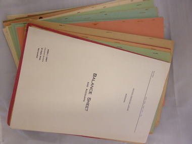
Box, Swintons, Box – early 20th century
This box contains a label from the Warrnambool business of W. Swinton & Sons and this tells us that the box dates from the early 20th century (pre 1912). The documents in the box are Swinton financial balance sheets from 1928 to 1970 (W. Swinton & Sons/Swintons Pty Ltd). William and Ann Swinton migrated to Australia in 1854 and for a decade William Swinton worked as a builder and carpenter in the Warrnambool area, erecting many buildings, including the Wangoom Presbyterian Church. In 1865 he opened a store in Timor Street Warrnambool, selling groceries, glassware, china and hardware. By 1888 the business was known as William Swinton and Sons. Branch stores were opened in Cudgee, Nullawarre, Wangoom, West Warrnambool and South Warrnambool. After William Swinton died his son Robert became the first managing director of Swintons Pty Ltd. In 1934 the business split, with George Swinton and Sons selling clothing, furnishings and glassware and Swintons Pty Ltd selling seeds, produce and hardware. Today the Swinton family still operates a furniture and bedding store in Timor Street. Both these items come from the Warrnambool business of W. Swinton & Son/Swintons Pty Ltd and both the box with its early 20th century label and the financial statements are of importance. The balance sheets will be useful to researchers. The current Swinton business in Timor Street is the oldest family business in Warrnambool and, with the name Swinton associated with Timor Street businesses for 152 years, it is amongst the oldest family businesses in Australia. .1 This is a black cardboard box with a lid, with one side of the lid party detached. Some parts of the box are torn, especially the corners of the lid. The inside of the box is somewhat stained. The inside of the lid has a label pasted on and the top of the lid has a W. Swinton & Sons label pasted on. The Swintons label is partly torn away. .2 The paper material inside the box is mostly foolscap-size and consists of business financial balance statements. Some of these have coloured paper covers. ‘W Swinton & Sons Universal Produce Buyers and Exporters Timor Street Warrnambool’ swinton family, warrnambool, history of warrnambool -
Whitehorse Historical Society Inc.
Map, Mitcham, 1880s?
Hand drawn map of area north and south of Whitehorse Road and South of Canterbury Road c.1880-1900.Hand drawn map of area north and south of Whitehorse Road and South of Canterbury Road c.1880-1900. Probably sketched by a McClare descendant. Includes locations and names of settlers of that time.Hand drawn map of area north and south of Whitehorse Road and South of Canterbury Road c.1880-1900. whitehorse road, mitcham, mitcham road, mitcham, l l vale road, vermont, canterbury road, mitcham -
 Federation University Historical Collection
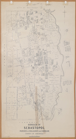
Plan, Borough of Sebastopol, 1940, 01/07/1940
Sebastopol became a suburb of the City of Ballarat.Plan showing the streets, allotments creeks in the Borough of Sebastopol, Parishes of Ballaarat and Cardigan, County of Grenville, in 1940. sebastopol, t. rider, yarrowee creek, leigh river, st george's reserve, leigh creek, sebastopol public gardens, sebastopol recreation reserve, gravel reserve, night soil depot, sanitary depot, rubbish depot -
Bendigo Historical Society Inc.
Map - KAMAROOKA ALLOTMENTS, 7/06/1894
Map: Parish of Kamarooka Allotments, County of Bendigo. Parish plan (number 288 in map cupboard 1)map, bendigo, allotments, kamarooka, allotments -
 Whitehorse Historical Society Inc.
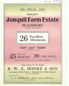
Document, Jonquil Farm Estate
Brochure of Richard's Jonquil Farm EstateBrochure of Richard's Jonquil Farm Estate featuring 26 allotments, 7 minutes from Blackburn Station.Brochure of Richard's Jonquil Farm Estate land subdivision, jonquil farm estate blackburn, laurel grove, blackburn, boongarry avenue, main street, linum street, hooke, r.w.e. & son, keegan, i.c. -
 Beechworth Honey Archive
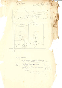
Hand-Drawn Diagram of Land by Frank Lebbell Frost September 1920
Hand-drawn diagram of land at Dookie by Frank L. Frost. Depicts plan od three allotments.hand drawn, hand-drawn, plan, land, dookie, frost, beekeeper, beechworth honey -
Canterbury History Group
Ephemera - Maling Road Canterbury, c1900
Copy of the brochure for the sale of ten allotments on the south side of Maling Road by the Equity Trustees Company c1900.canterbury, maling road, bryson street, equity trustees company limited -
Port Melbourne Historical & Preservation Society
Plan - Photographic copy, Plan of allotments marked at Sandridge, 1849, Lindsay Clarke, Surveyor, c. 1849
Photographic copy of 'Plan of allotments marked at Sandridge in the Parish of South Melbourne; by surveyor Lindsay Clarke 1849On back, '7' in inktown planning, business and traders - hotels, lindsay clarke, wilbraham frederick evelyn liardet, wfe liardet -
 Bendigo Historical Society Inc.
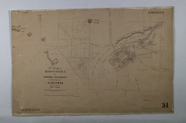
Map - KOOYOORA, July 23rd 1857
Map: The Township of Kooyoora and suburban allotments in the Parish of Kingower. This plan has been applied to a newer backingmap, township, kooyoora, allotments, parish of kingower -
 Ringwood and District Historical Society
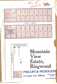
Map, Partially Trimmed Copy of Mountain View Estate Subdivision Advertisement, Ringwood, Vic. - (Undated, circa 1930s)
Clipped subdivision map on cardboard backing. 22 residential allotments on Daisy Street and Wantirna Road, Ringwood.Auctioneers - Phillips & Nicholson, 59 Swanston Street, Melbourne. Phone Central 10907. -
Clunes Museum
Map, A.C. BROOKS GOVERNMENT PRINTER MELBOURNE, EGLINTON COUNTY OF TALBOT, 1965
MAP OF EGLINTONMAP OF EGLINTON, COUNTY OF TALBOT PRINTED ON CANVAS WITH PLASTIC TAB FOR HANGING. MAP SHOWS TOWN ALLOTMENTSADMINISTRATIVE STAMP ON BOTTOM LEFT AND ON THE BACK OF THE MAP ANOTHER STAMP - NORTHERN DIVISION (299) FORESTS COMMISSION BENDIGOeglinton, historical map -
Whitehorse Historical Society Inc.
Article, Funding Blast at Government, 1992
The State Government has been accused of being callous and uncaringThe State Government has been accused of being callous and uncaring in refusing to supply a full time Social Worker for Nunawading Youth Support Group Reach out for Kids (ROK)The State Government has been accused of being callous and uncaring youth services, reach out for kids -
 Greensborough Historical Society
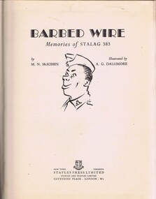
Book, Barbed Wire: memories of Stalag 383, by M N McKibbin, 1947_
Tells the story of Prisoners of War at Stalag 383 during World War II. Personal memoirs of inmates (prisoners of war) of Stalag 383. 128p., hard cover, black and white illustrations.Inscription: "To Uncle Ame and, this book was prepared & paid for thru' army allotments whilst we were still p.o.w's, Allick.prisoners of war, world war ii, stalag 383. -
 Ringwood and District Historical Society
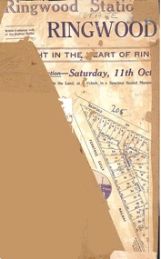
Map, Partially Trimmed Copy of Ringwood Station Estate Auction Notice, Ringwood, Vic. - 1919
Triangular clipping from subdivision auction advertisement on cardboard backing. Faint handwritten sales notations on numbered residential allotments in Bedford Road and Williams Grove (later Lena Grove), Ringwood. -
 St Kilda Historical Society
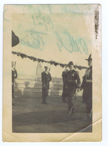
Photograph, St Kilda Pier, c. 1921
St Kilda Pier at the time of visit of HRH Prince Edward of Wales 1921black and white photograph, unmounted, original, poor conditionOn back: St Kilda Pier at the time of visit of HRH Prince Edward of Wales 1921. Presented by C Kelly 14-2-82 -
Glenelg Shire Council Cultural Collection
Document - Document - Conversion Chart, n.d
Port of Portland Authority Archivesport of portland archives -
 Ringwood and District Historical Society
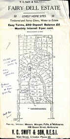
Flyer, Residential Land Sale Sub-division - Fairy Dell Estate, Warranwood, Vic. - circa 1950s
Land sale advertisement for 50 home sites with map of Sub-division showing layout of streets and allotments, summary of local features and services and terms of sale, and copy of sectional map of Crown Allotments 20 & 21B Parish of Warrandyte also showing layout of Sub-division.Subdivision includes Grandview Grove (later Bemboka Road), Merrill Crescent and Kerry Road, Warranwood. Estate Agents - V.C. Swift & Son R.E.S.I., Main Street, Croydon, Phone 20. Solicitors - Morgan, Fyffe & Mulkearns, 108 Queen Street, Melbourne. Handwritten 1970s real estate price notations for some blocks.