Showing 1464 items matching "victoria on the move"
-
 Kew Historical Society Inc
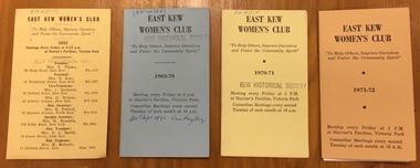
Document, East Kew Women's Club, East Kew Women's Club Yearly Meeting Schedules, 1953-1971
... meeting place, so the group moved to the Harrier’s Pavilion... meeting place, so the group moved to the Harrier’s Pavilion ...The East Kew Women’s Club was formed on 20 July 1945 as an experiment amongst local women, who felt that there was a need for some organised group to give full scope to their various interests and hobbies. In the beginning, they met at the house of their founder, Mrs Eric Thake, 48 Harp Road, East Kew, but the growth and interest was so rapid that it was soon necessary to find a larger meeting place, so the group moved to the Harrier’s Pavilion in Victoria Park, Kew. At the fifth meeting of the group, a committee was formed, and a constitution adopted on 4 December 1945.The Club was aimed to be non-political, non-sectarian and open to women from any locality. The Club’s motto was “To Help others, Improve Ourselves, and Foster the Community Spirit”. The first twenty years of the Club was recorded in a small, nine-page publication “East Kew Women’s Club : Twenty Years 20-7-1945 - 30-7-1965”. Following the closure of the Club in 1973, after twenty-eight years, its records were deposited with the Kew Historical Society and are thus available for research into the history of women’s groups in the post war period in Australia. The Society holds the Club’s Minute Books of Meetings (1953-73), Attendance Registers (1959-73), Visitors Book, and sundry items of print ephemera published by the Club.4 printed programs of meetings and activities of the East Kew Women's Club for the years 1953, 1969-70, 1970-71, 1971-72.clubs -- kew east (vic.), east kew women's club -
 Kew Historical Society Inc
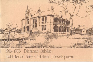
Booklet, Institute of Early Childhood Development, 1916-1976 Diamond Jubilee, 1976
The Free Kindergarten Union of Victoria commenced teacher training in 1909. A two year course was run in cooperation with the Education Department in 1910-14, but from 1917 the Union trained its students independently. In 1922 the Kindergarten Training College was established in Mooroolbeek, Kew. In 1965, the institution, as the Melbourne Kindergarten Teachers' College, became an entity separate from the Union, and in 1973 joined the State College of Victoria as the Institute of Early Childhood Development. It subsequently amalgamated with the University of Melbourne to become the Department of Early Childhood Studies and moved from Madden Grove, Kew, to 234 Queensberry St, Carlton, early in July 1997.[16]p. : ill., ports. ; 19 x 28 cm. Includes photographs of the Institute, its leaders and students. Included are a chronology and a number of photos (above) of Mooroolbeek, part of the complex, which is now all demolished.institute of early childhood development, mooroolbeek -
 Kew Historical Society Inc
Plan, Melbourne & Metropolitan Board of Works : Borough of Kew : Detail Plan No.1297, 1904
The Melbourne and Metropolitan Board of Works (MMBW) plans were produced from the 1890s to the 1950s. They were crucial to the design and development of Melbourne's sewerage and drainage system. The plans, at a scale of 40 feet to 1 inch (1:480), provide a detailed historical record of Melbourne streetscapes and environmental features. Each plan covers one or two street blocks (roughly six streets), showing details of buildings, including garden layouts and ownership boundaries, and features such as laneways, drains, bridges, parks, municipal boundaries and other prominent landmarks as they existed at the time each plan was produced. (Source: State Library of Victoria)This plan forms part of a large group of MMBW plans and maps that was donated to the Society by the Mr Poulter, City Engineer of the City of Kew in 1989. Within this collection, thirty-five hand-coloured plans, backed with linen, are of statewide significance as they include annotations that provide details of construction materials used in buildings in the first decade of the 20th century as well as additional information about land ownership and usage. The copies in the Public Record Office Victoria and the State Library of Victoria are monochrome versions which do not denote building materials so that the maps in this collection are invaluable and unique tools for researchers and heritage consultants. A number of the plans are not held in the collection of the State Library of Victoria so they have the additional attribute of rarity.Original survey plan, issued by the MMBW to a sewage contractor with responsibility for constructing sewers in the area identified on the plan within the Borough of Kew. The plan was at some stage hand-coloured, possibly by the contractor, but more likely by officers working in the Engineering Department of the Borough and later Town, then City of Kew. The hand-coloured sections of buildings on the plan were used to denote masonry or brick constructions (pink), weatherboard constructions (yellow), and public buildings (grey). This plan of Kew encompasses the area bounded by Barkers Road, High Street and Stevenson Street. Because of the angle created by High Street, a number of houses on the northern side of High Street are shown. The area is dominated by one of the great original landholdings in Kew, described here as the ‘Findon Paddock’. ‘Findon’, the house from which the name of the paddock was taken fronts Stevenson Street and was clearly a rambling structure. The best-known occupant of Findon was Henry ‘Money Miller’ who bought the house in 1871. Miller was a member of Victoria’s first parliament and assisted in the framing of its constitution. Findon was to be subdivided as early as 1912, when the Findon Subdivision was advertised to be sold by auction. In the plan of the subdivision, the original house is not shown, so, presumably it had previously been demolished. Fincham & Son moved the organ, built by Henry Willis, which was installed in the house, first to ‘Whernside’ in Toorak, and later to the Box Hill Methodist Church.melbourne and metropolitan board of works, detail plans, mmbw 1297, cartography, kew (vic.) — municipal collection -
 Kew Historical Society Inc
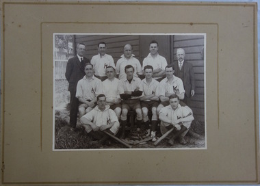
Photograph, Kew Baseball Club, c.1927
The Victorian Baseball League was established in 1889 with the following clubs - MCC, Metropolitan, Richmond, Richmond Cricketers, Kew, Geelong, Fitzroy, The Age, Carlton, Coburg. MCC defeated Metropolitan for the first Premiership. By 1897 Kew had built up to six teams, but went into recess about the turn of the century. They reformed c.1906 and did not resume until 1926 under Captain/Coach Frank Littlefield. I think he was ex Hawthorn Baseball and/or Cricket club(s). They won the D Grade Premiership of 1926 and/or 1927 playing out of Victoria Park at 12 noon, and as a curtain raiser to either Kew or Kew District or East Kew Football Club and after World War 2, North Kew which had now joined Kew as a tenant. Team members were H.L. Barclay (ex Richmond), A. Brierley (ex Collingwood), H. Ely (ex Essendon), Frank Littlefield, J. Marshall and C. Robinson (ex Hawthorn-East Melb Cricket Club). In 1926, the KBC played against Caulfield, Fairfield, Fitzroy, Ivanhoe, Northcote, Prahran, University, Williamstown, YMCA. In 1927, Preston replaced Fairfield. A third team was formed post WW2 which played at Willsmere Park. The Reserves followed to Willsmere Park in 1963 and the Seniors in c.1970. Kew Council moved the club to a sub-standard Stradbroke Park No 2 Oval for the 1976 season and this proved to be the last for the club. Melbourne Baseball Club moved in for two seasons, but also moved when improvements to No 2 Oval were not made. They then moved to Macleay Park in a share arrangement with North Balwyn BC. Research: Ian JobTeam photo of the Kew Baseball Club players and club officials and or supporters. The grandfather of the donor, Christopher Robinson has been identified as sitting in the middle row, 2nd from left.kew baseball club, victoria park -
 Kew Historical Society Inc
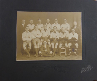
Photograph, The Burlington Studios, Kew Baseball Club, c. 1926
The Victorian Baseball League was established in 1889 with the following clubs - MCC, Metropolitan, Richmond, Richmond Cricketers, Kew, Geelong, Fitzroy, The Age, Carlton, Coburg. MCC defeated Metropolitan for the first Premiership. By 1897 Kew had built up to six teams, but went into recess about the turn of the century. They reformed c.1906 and did not resume until 1926 under Captain/Coach Frank Littlefield. I think he was ex Hawthorn Baseball and/or Cricket club(s). They won the D Grade Premiership of 1926 and/or 1927 playing out of Victoria Park at 12 noon, and as a curtain raiser to either Kew or Kew District or East Kew Football Club and after World War 2, North Kew which had now joined Kew as a tenant. Team members were H.L. Barclay (ex Richmond), A. Brierley (ex Collingwood), H. Ely (ex Essendon), Frank Littlefield, J. Marshall and C. Robinson (ex Hawthorn-East Melb Cricket Club). In 1926, the KBC played against Caulfield, Fairfield, Fitzroy, Ivanhoe, Northcote, Prahran, University, Williamstown, YMCA. In 1927, Preston replaced Fairfield. A third team was formed post WW2 which played at Willsmere Park. The Reserves followed to Willsmere Park in 1963 and the Seniors in c.1970. Kew Council moved the club to a sub-standard Stradbroke Park No 2 Oval for the 1976 season and this proved to be the last for the club. Melbourne Baseball Club moved in for two seasons, but also moved when improvements to No 2 Oval were not made. They then moved to Macleay Park in a share arrangement with North Balwyn BC. Research: Ian JobTeam photo of the Kew Baseball Club players and club officials and or supporters. The grandfather of the donor, Christopher Robinson has been identified as sitting in the back row, 2nd from left.kew baseball club, victoria park, christopher robinson -
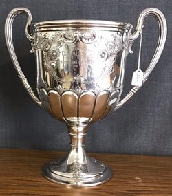 8th/13th Victorian Mounted Rifles Regimental Collection
Artwork, other - 20th LH trophy
Donated to the 8th/13th VMR Collection as part of a collection of regimental silver from the 20th Light Horse Regiment circa 1950. 20th Light Horse (Victorian Mounted Rifles) was raised following WWI as part of the 2nd Cavalry Brigade AMF. It had its HQ at Seymour and sub-units along the Goulburn Valley extending to Tocumwal in NSW. During WWII the regiment was motorised then served as infantry in Dutch New Guinea. It was the only light horse regiment to serve overseas in WWII.Is a representative example of a trophy from between the wars. The size, material and decoration show the relative affluence of the officers of a regiment from regional Victoria. The fact it carries no record of being awarded might indicate it dates from immediately prior to WWII when the regiment was mobilised and moved from its base area.Ornate silver cup with two handles intended for shooting competition in 20th Light Horse Regiment. There is no record of it being awarded."Field Firing Trophy / presented / by the Officers of the / 20th Australian Light Horse Regiment / Won by". Hallmarks on base and "8725 6PT"trophy, 20th light horse, cup -
 8th/13th Victorian Mounted Rifles Regimental Collection
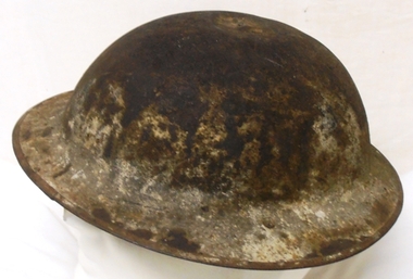
Headwear - Helmet - AIF, WWI, circa 1916
Regimental 543 Trooper Geoff Gilbert of Northcote Victoria enlisted in the 13th Light Horse Regiment AIF aged 21. He served at Gallipoli and Egypt before the regiment moved to the Western Front in March 1916 as Corps cavalry. Steel helmets and gas masks became regular equipment as the regiment engaged in all the major actions involving the Australians. Gilbert brought his helmet home after the war as a souvenir.Rare souvenir of headwear worn by an Australian light horseman of World War 1 (1914-18). Steel helmet worn on the Western Front by Lance Corporal Geoff Gilbert 13th Australian Light Horse during World War 1 (1914-1918).helmet, 13th light horse, wwi, world war one, the great war, first world war, gallipoli, australian imperial forces, aif -
 Queen Victoria Women's Centre
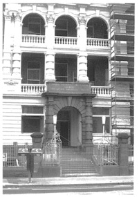
Photograph, c.1992
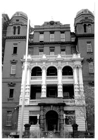
Black and white photograph. Photo of block E's facade of the Queen Victoria Memorial Hospital which was to be QVWC. Before restoration and after the hospital had moved to Clayton. Taken from Lonsdale street, scaffolding left of frame. historic buildings, hospitals, charitable organisations, cultural structures and establishments -
 Queen Victoria Women's Centre
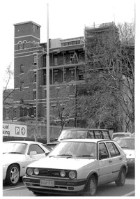
Photograph, c.1992
Black and white photograph. Photo o western side of block E of the Queen Victoria Memorial Hospital which was to be the QVWC before the restoration and after the hospital had moved to Clayton. From Lonsdale street with a number of cars in the foreground of photograph. Scaffolding at right of frame. historic buildings, hospitals, cultural structures and establishments -
 Queen Victoria Women's Centre
Photograph, c.1992
Black and white photograph. Photo of whole facade of block E of the Queen Victoria Memorial Hospital. Taken from Lonsdale street. Before restoration and after the hospital had moved to Clayton.historic buildings, hospitals, cultural structures and establishments -
 Queen Victoria Women's Centre
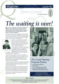
Newsletter, Q Magazine: The waiting is over!, December 1996
Documenting the move into the QVWC building on Lonsdale streetA4 printer paper. 8 pages. Navy text on cream paper. Taupe toned accents and photographs throughout. newsletter, historical site, cultural structures and establishments -
 Glen Eira City Council History and Heritage Collection
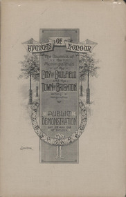
Booklet, "AVENUES OF HONOUR The Councils of the Municipalities of the CITY OF CAULFIELD TOWN OF BRIGHTON acting in conjunction PUBLIC DEMONSTRATION SAT 3rd AUG. 1918 AT 3oCLOCK"
Souvenir Programme from the Councils of the Municipalities of the City of Caulfield and the Town of Brighton for a Public Demonstration to be held on Sat 3rd August 1918 at 3 o'clock for the proposed Avenues of Honour to be planted in memory of fallen WWI soldiers. From Honour Roll Display 2019 interpretation panel - Brighton-Caulfield Avenue of Honour It is hard to imagine but a grand arboreal Avenue of Honour once lined parts of North Road, McMillan Street and Point Nepean Road (now Nepean Highway). The Avenue of Honour was a distinctly Australian phenomenon with hundreds being constructed throughout Australia during and following World War One, most of these in Victoria. Consisting of tree lined streets with each tree representing a solider, the Avenue of Honour signalled a more egalitarian approach to commemoration where rank was not a consideration. Arguably the most famous Avenue of Honour in Victoria still exists at Ballarat. Stretching for nearly 22 kilometres, the entrance to the Avenue is marked by the imposing Arch of Victory. Smaller in scale, the Brighton-Caulfield Avenue of Honour was dedicated to the ‘memory of (Brighton and Caulfield’s) kith and kin who came from (the) district and who died in the Great War’. A joint project between the neighbouring Councils, the idea was first reported in The Argus on 1 July 1918. Plans moved along quickly and on 3 August 1918 the Governor of Victoria Arthur Stanley planted the first Australian flowering gum. The next of kin were then invited to plant trees for lost sons, brothers, uncles, nephews and husbands. In all, over 400 trees were planted. Intensely personal, the Avenue also acted as a focus of grief and remembrance for the wider community. For many years, the annual civic Anzac Day service was held at the Avenue on Point Nepean Road, near Glen Huntly Road, Elsternwick. The service was moved to Caulfield Park upon the completion of the Cenotaph in 1930. Due to road widening and disease the last original tree was replaced in the 1980s, however a plaque in Caulfield Park records the Avenue’s plantation. Commemorative booklet, grey cover with text printed on the grey textured paper cover and an image of four trees and a wreath. Image of a kookaburra on the back. Inside, 28 numbered pages with b/w text and photographic images including a transparent paper representation of the proposed Avenues of Honour on Brighton Road and Point Nepean Road. Souvenir programme for a Public Demonstration for the Avenues of Honour as detailed on the front.city of caufield, world war one, first world war, anzac, remembrance, town of brighton, brighton, caulfield, avenue of honour -
 Glen Eira City Council History and Heritage Collection
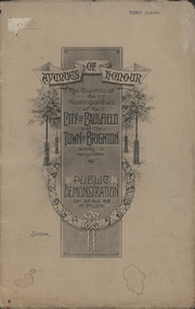
Booklet, D. W. Paterson Co. Pty. Ltd, "AVENUES OF HONOUR The Councils of the Municipalities of the CITY OF CAULFIELD TOWN OF BRIGHTON acting in conjunction PUBLIC DEMONSTRATION SAT 3rd AUG. 1918 AT 3oCLOCK SOUVENIR"
Souvenir Programme from the Councils of the Municipalities of the City of Caulfield and the Town of Brighton for a Public Demonstration to be held on Sat 3rd August 1918 at 3 o'clock for the proposed Avenues of Honour to be planted in memory of fallen WWI soldiers. One of two known copies, this copy has "Town Clerk" stamped in the upper corner, rhs.Commemorative booklet, grey cover with text printed on the grey textured paper and an image of four trees and a wreath. Image of a kookaburra on the back. Inside, 28 numbered pages with b/w text and photographic images including a transparent paper representation of the proposed Avenues of Honour on Brighton Road and Point Nepean Road. Souvenir programme for a Public Demonstration for the Avenues of Honour as detailed on the front. From Honour Roll Display 2019 interpretation panel - Brighton-Caulfield Avenue of Honour It is hard to imagine but a grand arboreal Avenue of Honour once lined parts of North Road, McMillan Street and Point Nepean Road (now Nepean Highway). The Avenue of Honour was a distinctly Australian phenomenon with hundreds being constructed throughout Australia during and following World War One, most of these in Victoria. Consisting of tree lined streets with each tree representing a solider, the Avenue of Honour signalled a more egalitarian approach to commemoration where rank was not a consideration. Arguably the most famous Avenue of Honour in Victoria still exists at Ballarat. Stretching for nearly 22 kilometres, the entrance to the Avenue is marked by the imposing Arch of Victory. Smaller in scale, the Brighton-Caulfield Avenue of Honour was dedicated to the ‘memory of (Brighton and Caulfield’s) kith and kin who came from (the) district and who died in the Great War’. A joint project between the neighbouring Councils, the idea was first reported in The Argus on 1 July 1918. Plans moved along quickly and on 3 August 1918 the Governor of Victoria Arthur Stanley planted the first Australian flowering gum. The next of kin were then invited to plant trees for lost sons, brothers, uncles, nephews and husbands. In all, over 400 trees were planted. Intensely personal, the Avenue also acted as a focus of grief and remembrance for the wider community. For many years, the annual civic Anzac Day service was held at the Avenue on Point Nepean Road, near Glen Huntly Road, Elsternwick. The service was moved to Caulfield Park upon the completion of the Cenotaph in 1930. Due to road widening and disease the last original tree was replaced in the 1980s, however a plaque in Caulfield Park records the Avenue’s plantation. Inkstamp upper corner rhs: "TOWN CLERK" -
 Glen Eira City Council History and Heritage Collection
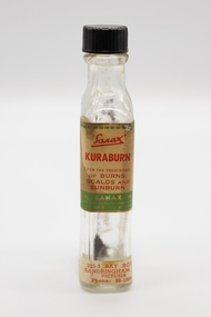
Kuraburn bottle
This Kuraburn Bottle is part of a Sanax First Aid Case which was used at the the former Carnegie Senior Citizens' Centre. The centre was located at 314 Neerim Road, Carnegie. When the Neerim Road facility closed, its activities were moved to the Carnegie Library and Community Centre. For Occupational Health and Safety reasons, Council no longer maintains first aid kits at senior citizens' centres. Clear glass bottle with two paper labels on narrow side. One red, green, white and black label with Sanax branding, one red and white label at base of bottle with address and contact details. Black plastic screw-top lid with a section missing. Bottle has been decanted however some residue remains. Small cork stopper contained within bottle."Sanax" KURABURN / FOR THE TREATMENT / OF BURNS / SCALDS AND / SUNBURN / THE SANAX CO. / 849-51 NEPEAN HIGHWAY / MOORABIN / TEL XU 2651 / Left side of label: Directions: Dab on lightly, and repeat in two hours if necessary. Applied early, it prevents blistering. Right side of label: Allow to dry on the skin before putting on wearing apparel, to avoid staining the clothes. 223-5 BAY ROAD, / SANDRINGHAM, S.8 / VICTORIA / Phone: 98-1604 -
 8th/13th Victorian Mounted Rifles Regimental Collection
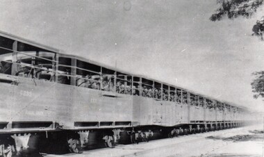
Photograph
The 13th Light Horse Regiment (AIF) was raised t Broadmeadows Victoria in March 1915. Following service at Gallipoli the regiment was broken up with squadrons going to France as Divisional Cavalry Squadrons of 2nd, 4th and 5ht Divisions. The regiment was reformed as firstly 1st Anzac Corps Mounted Troops and lather Australian Corps Mounted TroopsBlack and white photograph of horses in rail wagons. Probably taken in France during the move of the 13 ALH from Marsailles to the Western Front 1916. -
 8th/13th Victorian Mounted Rifles Regimental Collection
Photograph
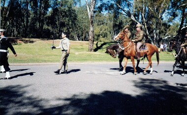
The 8/13 VMR provided soldiers to Anzac Day marches and services in NE Victoria and Southern NSW.The 8th/13th Victorian Mounted Rifles was raised as a regiment of the Royal Australian Armoured Corps on 1 May 1948 with Headquarters in Melbourne and squadrons in Sale, Benalla/Wangaratta and Albury. In 1955 Regimental Headquarters moved to Wangaratta and a second squadron was located at Albury. The Sale squadron transferred to 4th/19th Prince of Wales’s Light Horse. In 1977 8/13 VMR Regiment was reduced to an independent squadron A Squadron 8th/13th Victorian Mounted Rifles and in 1991 was linked with 4th/19th Prince of Wales’s Light Horse forming the VMR Squadron of that regiment.Colour photograph of Lieutenant John Burke, 8/13 Victorian Mounted Rifles followed by the VMR Heritage Troop on Anzac Day at Tocumwal NSW 1989 -
 8th/13th Victorian Mounted Rifles Regimental Collection
Photograph
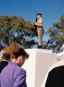
The 8/13 VMR provided soldiers to Anzac Day marches and services in NE Victoria and Southern NSW. The 8th/13th Victorian Mounted Rifles was raised as a regiment of the Royal Australian Armoured Corps on 1 May 1948 with Headquarters in Melbourne and squadrons in Sale, Benalla/Wangaratta and Albury. In 1955 Regimental Headquarters moved to Wangaratta and a second squadron was located at Albury. The Sale squadron transferred to 4th/19th Prince of Wales’s Light Horse. In 1977 8/13 VMR Regiment was reduced to an independent squadron A Squadron 8th/13th Victorian Mounted Rifles and in 1991 was linked with 4th/19th Prince of Wales’s Light Horse forming the VMR Squadron of that regiment.Colour photograph of 8/13 Victorian Mounted Rifles soldier, Trooper Paul Maccioni, as a sentry at Albury War Memorial, Anzac Day 1989 -
 8th/13th Victorian Mounted Rifles Regimental Collection
Photograph
The 8/13 VMR provided soldiers to Anzac Day marches and services in NE Victoria and Southern NSW..The 8th/13th Victorian Mounted Rifles was raised as a regiment of the Royal Australian Armoured Corps on 1 May 1948 with Headquarters in Melbourne and squadrons in Sale, Benalla/Wangaratta and Albury. In 1955 Regimental Headquarters moved to Wangaratta and a second squadron was located at Albury. The Sale squadron transferred to 4th/19th Prince of Wales’s Light Horse. In 1977 8/13 VMR Regiment was reduced to an independent squadron A Squadron 8th/13th Victorian Mounted Rifles and in 1991 was linked with 4th/19th Prince of Wales’s Light Horse forming the VMR Squadron of that regiment.Colour photograph of Major Ian Docking, 8/13 Victorian Mounted Rifles, leading the Anzac Day march in Albury 1989. He is mounted in a heritage Ferret Scout Car. -
 8th/13th Victorian Mounted Rifles Regimental Collection
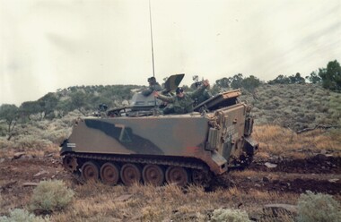
Photograph - Training South Australia
The 8th/13th Victorian Mounted Rifles was raised as a regiment of the Royal Australian Armoured Corps on 1 May 1948 with Headquarters in Melbourne and squadrons in Sale, Benalla/Wangaratta and Albury. In 1955 Regimental Headquarters moved to Wangaratta and a second squadron was located at Albury. The Sale squadron transferred to 4th/19th Prince of Wales’s Light Horse. In 1977 8/13 VMR Regiment was reduced to an independent squadron A Squadron 8th/13th Victorian Mounted Rifles and in 1991 was linked with 4th/19th Prince of Wales’s Light Horse forming the VMR Squadron of that regiment.Collection of six colour photographs showing members of 'A' Squadron 8/13 Victorian Mounted Rifles on a Driving and Servicing Course at Port Augusta South Australia, 1989. The location allowed crewmen from north-east Victoria to experience vastly different operating conditions. The 8th/13th Victorian Mounted Rifles was raised as a regiment of the Royal Australian Armoured Corps on 1 May 1948 with Headquarters in Melbourne and squadrons in Sale, Benalla/Wangaratta and Albury. In 1955 Regimental Headquarters moved to Wangaratta and a second squadron was located at Albury. The Sale squadron transferred to 4th/19th Prince of Wales’s Light Horse. In 1977 8/13 VMR Regiment was reduced to an independent squadron A Squadron 8th/13th Victorian Mounted Rifles and in 1991 was linked with 4th/19th Prince of Wales’s Light Horse forming the VMR Squadron of that regiment.military, vmr, m113, training, south australia -
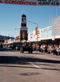
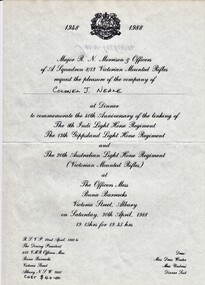 8th/13th Victorian Mounted Rifles Regimental Collection
Document - Invitation to a regimental dinner
The 8th/13th Victorian Mounted Rifles was raised as a regiment of the Royal Australian Armoured Corps on 1 May 1948 with Headquarters in Melbourne and squadrons in Sale, Benalla/Wangaratta and Albury. In 1955 Regimental Headquarters moved to Wangaratta and a second squadron was located at Albury. The Sale squadron transferred to 4th/19th Prince of Wales’s Light Horse. In 1977 8/13 VMR Regiment was reduced to an independent squadron A Squadron 8th/13th Victorian Mounted Rifles and in 1991 was linked with 4th/19th Prince of Wales’s Light Horse forming the VMR Squadron of that regiment.Representative of social life of an armoured regiment in regional Victoria.Single page printed document being invitation to a formal dinner to commemorate the linking of 8th 13th and 20th Light Horse Regiments for form the 8/13 Victorian Mounted Rifles on 1 May 1948.Colonel J Nealemilitary, 8/13 vmr, dinner, anniversary, linking -
 Surrey Hills Historical Society Collection
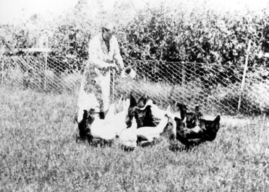
Photograph, Mrs Jessie Crow feeding fowls
... Examinations Board. He married lyric soprano, Jessie Temby and moved... Temby and moved to ‘Strathmore’, 75 Victoria Crescent, Mont ...The property is identified as 'Strathmore', the home of Joseph Sutton Crow and his wife Winifred (Jessie) Temby, whom he married in 1910. Joseph Sutton Crow: (1881-1969) - Joseph Sutton Crow gained his Diploma of Music from the Marshall Hall Conservatorium, the forerunner to the Melbourne University Conservatorium, in 1907. He taught both piano and organ and was organist and choirmaster in several churches. However it was as a fine administrator that Sutton Crow made a significant contribution to music in Melbourne. From 1910-1920 he was Secretary and Librarian of the Music Department at the University of Melbourne and from 1920 was the Secretary and Assistant Director of the Conservatorium of Music. From 1919 he was also Secretary of the Australian Music Examinations Board. He married lyric soprano, Jessie Temby and moved to ‘Strathmore’, 75 Victoria Crescent, Mont Albert in 1924 and lived there until 1952. In c1926 he was one of those behind establishing the public appeal to raise a million shillings to go towards the establishment of a permanent Symphony Orchestra. The appeal successfully raised both £4000 and the profile of orchestral music in Melbourne. The result was the Melbourne University Symphony Orchestra, which later became the Melbourne Symphony Orchestra, and from 1926-1939 he was its manager. Close local musical contemporaries were violinist Stanislau de Tarczynski and pianist Edward Goll, both of whom lived in Mont Albert. Winifred Jessie Temby (1883 - 1968) - soprano The donor was their daughter.A black and white photograph of a lady holding a sauce pan in her left hand and ladling out food to the fowls in front of her. Behind her there is a fenced off area with trees behind it.'strathmore', house names, victoria crescent, mont albert, surrey hills, joseph sutton crow (mr), winifred jessie temby (miss), jessie tremby (miss), winifred jessie crow (mrs), jessie crow (mrs), orchards, jean crow (miss) -
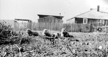 Surrey Hills Historical Society Collection
Photograph, Backyard of 'Strathmore', 75 Victoria Crescent, early 20th century
... Examinations Board. He married lyric soprano, Jessie Temby and moved... Temby and moved to ‘Strathmore’, 75 Victoria Crescent, Mont ...The property is identified as 'Strathmore', the home of Joseph Sutton Crow and his wife Winifred (Jessie) Temby, whom he married in 1910. Joseph Sutton Crow: (1881-1969) - Joseph Sutton Crow gained his Diploma of Music from the Marshall Hall Conservatorium, the forerunner to the Melbourne University Conservatorium, in 1907. He taught both piano and organ and was organist and choirmaster in several churches. However it was as a fine administrator that Sutton Crow made a significant contribution to music in Melbourne. From 1910-1920 he was Secretary and Librarian of the Music Department at the University of Melbourne and from 1920 was the Secretary and Assistant Director of the Conservatorium of Music. From 1919 he was also Secretary of the Australian Music Examinations Board. He married lyric soprano, Jessie Temby and moved to ‘Strathmore’, 75 Victoria Crescent, Mont Albert in 1924 and lived there until 1952. In c1926 he was one of those behind establishing the public appeal to raise a million shillings to go towards the establishment of a permanent Symphony Orchestra. The appeal successfully raised both £4000 and the profile of orchestral music in Melbourne. The result was the Melbourne University Symphony Orchestra, which later became the Melbourne Symphony Orchestra, and from 1926-1939 he was its manager. Close local musical contemporaries were violinist Stanislau de Tarczynski and pianist Edward Goll, both of whom lived in Mont Albert. Winifred Jessie Temby (1883 - 1968) - soprano A black and white photograph of three sheep lying in the grounds of a house. There is a house and some sheds in the background behind a picket fence.'strathmore', house names, victoria crescent, mont albert, surrey hills, joseph sutton crow (mr), winifred jessie crow (mrs), jessie crow (mrs), jessie temby (miss), winifred jessie temby (miss), orchards, music -
 Surrey Hills Historical Society Collection
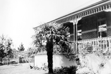
Photograph, 3 Beatty Street, Mont Albert
Location is now 3 Beatty Street, Mont Albert although electoral entries for the Lodewyckx family in the 1930s give the address as 1 Beatty Street. This address is a more contemporary house and part of the original garden was subdivided off at some stage. The property's original address was 1 Victoria Street, renamed in 1917. The house was built c 1891 and from then until 1905 it was home to Leopold A Carter (dentist of Collins Street); followed by James J Hempill (broker) from 1905 -1907. he called it 'Manchling'. There were several other owners or tenants before the Lodewyckx family moved into it in 1920. They named the property 'Huize Eikenbosch' (Dutch meaning House of Oaks). It was set in 1/3 hectare with a formal garden, vegetable garden, orchard and chicken run. Augustin had a life-long interest in growing vegetables and planted many European trees, especially oaks. Augustin Lodewyckx was born and educated in Belgium, was appointed Professor of Modern Languages at Stellenbosch, South Africa and later joined the Belgium Colonial Service. In 1915 he commenced as lecturer in German at Melbourne, becoming Associate Professor in 1923. He had married Anna Sophia Hansen* in South Africa in 1910. They had 2 children Karel Axel, librarian of the University of Melbourne, and daughter Hilma Dymphna, translator, editor and wife of Manning Clark, historian. In 1942 Augustin introduced a university course in Dutch and also undertook research into German immigration to Australia. He retired in 1946 and died in 1964. (*Thought to be nick-named Mina.) A black and white photograph of a corner of a house with a large palm tree in front. There is decorative wooden balustrading on the verandah.beatty street, mont albert, mina lodewyckx (mrs), augustin lodewyckx (mr), karel axel lodewyckx (mr), axel lodewyckx (mr), anna sophia lodewyckx (mrs), hilma dymphna lodewyckx (miss), dymphna lodewyckx (miss), hilma dymphna clark (mrs), dymphna clark (mrs), architectural features -
 Surrey Hills Historical Society Collection
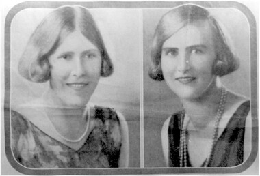
Photograph, Nancy and Hattie Steele
Nancy (Margaret Dillon) Steele born 1906 and Hattie ( Harriette Vevers) Steele were daughters of Charles Henri Dillon Steele (1869-1935) and Sarah Margaret Russell (1873-1944),he was a pioneer of dentistry in Victoria who was in practice in 1890 and later in Collins Street for 40 years. The family lived at ‘Dalriada’ (dem.) on the corner of Bona Vista Avenue and Union Road. Sarah Margaret Steele was President of the local Patriotic League during WW1 and is credited with starting the move to raise funds for the WW1 memorial in the Surrey Gardens. Nancy and Hattie were graduates at Melbourne University in Dentistry and Agricultural Science respectively. They continued their studies in Toronto and obtained their Doctorates. In 1923 Nancy and Hattie started the first girl guide group in Surrey Hills at Holy Trinity Church. Both married and had families. Nancy married Dr William Brayshaw Woodhouse and, while he took up army duties during World War II, Nancy continued his practice. Their son Anthony became a dentist, while Peter was known locally when he became a councillor and Mayor of Camberwell. Their daughter Margaret married Herbert Andrewartha and lived in NSW.A black and white photograph of two portraits of two young ladies. Their dress and hair styles are suggestive of a 1920's date..(miss) nancy (margaret) steele, (miss) hattie vevers steele, dalriada, house names, bona vista avenue, union road, surrey hills, dentists, first girl guide group, 1923, holy trinity church, world war, 1939-1945, mayors, councillors, (miss) margaret brayshaw-woodhouse, dr william brayshaw woodhouse, peter brayshaw woohdhouse, dr charles henri dillon steele, dr anthony brayshaw woodhouse, (miss) nancy steele, (mrs) nancy andrewartha, (miss) hattie steele, (miss) harriette vevers steele, (mrs) margaret brayshaw woodhouse, (miss) margaret dillon steele, (miss) sarah margaet russell, (mes) sarah margaret steele -
 Surrey Hills Historical Society Collection
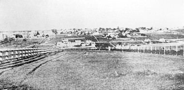
Photograph, Looking towards Box Hill from the site of the Surrey Hills Golf Club, 1902, 1902
Reproduced by permission of Mr John Arnold from his book: "The Riversdale Golf Club - a history, 1892-1977." Copyright to book: Riversdale Golf Club. Surrey Hills Golf Club operated from 1892-1908 then moved and became Riversdale Golf Club. The game was played across paddocks from Trafalgar Street, Mont Albert to Whitehorse Road and down Victoria Crescent to where Box Hill TAFE is now located in Elgar Road. There were problems with cows eating the tee flags! The clubhouse still exists as 30 Trafalgar Street.Black and white photo with a large grassy paddock in the foreground. From the bottom left and right post-and-rail fences converge on a group of large industrial buildings in the centre middle distance. In the background are paddocks and buildings."Top: Looking towards Box Hill from the links in 1902. The old Box Hill Gas Works is in the centre of the picture."sports grounds, surrey hills golf club, riversdale golf club, box hill gas works, gasworks, public utilities, gas -
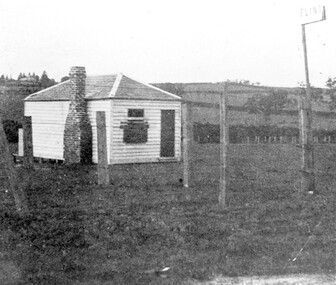 Surrey Hills Historical Society Collection
Photograph, The gate-keeper's shed, Surrey Hills Golf Club
Reproduced by permission of Mr John Arnold from his book: "The Riversdale Golf Club - a history, 1892-1977." Copyright to book: Riversdale Golf Club. Surrey Hills Golf Club operated from 1892-1908 then moved and became Riversdale Golf Club. The game was played across paddocks from Trafalgar Street, Mont Albert to Whitehorse Road and down Victoria Crescent to where Box Hill TAFE is now located in Elgar Road. There were problems with cows eating the tee flags! The clubhouse still exists as 30 Trafalgar Street.Apart from it association with the Surrey Hills Golf Club which is long gone, this image documents the landscape of pre-urban Surrey Hills.Black and white photo of a rectangular timber building with a slate hip roof and brick chimney on the LHS. The one visible window appears to be boarded up and has a door to its right. The building is fenced by posts and wire. A (?) street sign bearing the letters FLINT is at the right of the picture."The gate-keeper's shed was used as a clubhouse from 1895-1900."sports grounds, surrey hills golf club, riversdale golf club, timber building, john arnold -
 Surrey Hills Historical Society Collection
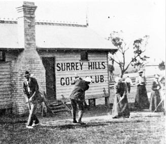
Photograph, Surrey Hills Golf Club clubhouse and players
Reproduced by permission of Mr John Arnold from his book: "The Riversdale Golf Club - a history, 1892-1977." Copyright to book: Riversdale Golf Club. Surrey Hills Golf Club operated from 1892-1908 then moved and became Riversdale Golf Club. The game was played across paddocks from Trafalgar Street, Mont Albert to Whitehorse Road and down Victoria Crescent to where Box Hill TAFE is now located in Elgar Road. There were problems with cows eating the tee flags! The clubhouse still exists as 30 Trafalgar Street. The Surrey Hills Golf Club was founded by Mr Hugh W McLeod in 1894. The first president was Mr A W Harston. Mr William Meader was the first honorary secretary and the club champion for several years. Another notable identity was Mr. Harry Culliton, who contributed golf notes to "The Argus" for many years.The image is significant in documenting the Surrey Hills Golf Club which is no longer in existence.Black and white photo of a timber building with an ornamental roof ridge and brick chimney. Two men in 'plus fours' and hats and three women in long dresses and hats have golf clubs in their hands. The men and one lady are practising swings. There is a mature tree in the background with a house to the right."A group of Surrey Hills players practising in front of the clubhouse early this century. The player in the background is heading towards the first tee. The house to his right can still be seen at 3 Beatty St., Mont Albert."sports grounds, surrey hills golf club, riversdale golf club, timber building, clothing and dress, john arnold -
 Surrey Hills Historical Society Collection
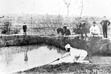
Photograph, Surrey Hills Golf Club water hazard, 1895, 1895
Reproduced by permission of Mr John Arnold from his book: "The Riversdale Golf Club - a history, 1892-1977." Copyright to book: Riversdale Golf Club. Surrey Hills Golf Club operated from 1892-1908 then moved and became Riversdale Golf Club. The game was played across paddocks from Trafalgar Street, Mont Albert to Whitehorse Road and down Victoria Crescent to where Box Hill TAFE is now located in Elgar Road. There were problems with cows eating the tee flags! The clubhouse still exists as 30 Trafalgar Street.Apart from its association in documenting the Surrey Hills Golf Club which has long disappeared, this image documents the landscape in the pre-urban era.Black and white photo of a scene at Surrey Hills Golf Club. There is a water hazard in the foreground with a lady on her knees trying to retrieve a ball from the water's edge. Three lads, one on a horse, are watching, as are 3 males to the right."In water" in the bottom right of the photo. Caption: "Captain Fred Andrew watches his partner's misfortunes during a game at Surrey Hills in 1895."sports grounds, surrey hills golf club, riversdale golf club -
 Surrey Hills Historical Society Collection
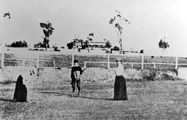
Photograph, Surrey Hills Golf Club eighth hole, 1902, 1902
Reproduced by permission of Mr John Arnold from his book: "The Riversdale Golf Club - a history, 1892-1977." Copyright to book: Riversdale Golf Club. Surrey Hills Golf Club operated from 1892-1908 then moved and became Riversdale Golf Club. The game was played across paddocks from Trafalgar Street, Mont Albert to Whitehorse Road and down Victoria Crescent to where Box Hill TAFE is now located in Elgar Road. There were problems with cows eating the tee flags! The clubhouse still exists as 30 Trafalgar Street. No 3 Beatty Street is in the background. The players are probably standing on what is now Zetland Road.This image is important not only for documentation of early sporting activities in the area but also for evidence of the pre-urban appearance of the landscape.Black and white photo with 2 ladies with golf clubs in the foreground and a lad (? caddy) with a golf bag under his arm. He is wearing a cap and 'plus fours'. The ladies are wearing long skirts, blouses and hats. Behind is a post-and-rail fence with a house and trees in the background.Caption: " Bottom: Putting out on the eighth hole, 1902."sports grounds, surrey hills golf club, riversdale golf club, clothing and dress, zetland road, surrey hills, john arnold -
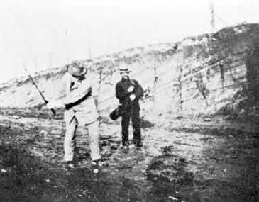 Surrey Hills Historical Society Collection
Photograph, Surrey Hills Golf Club - the cutting in (now) Whitehorse Road, 1905, 1905
Reproduced by permission of Mr John Arnold from his book: "The Riversdale Golf Club - a history, 1892-1977." Copyright to book: Riversdale Golf Club. Surrey Hills Golf Club operated from 1892-1908 then moved and became Riversdale Golf Club. The game was played across paddocks from Trafalgar Street, Mont Albert to Whitehorse Road and down Victoria Crescent to where Box Hill TAFE is now located in Elgar Road. There were problems with cows eating the tee flags! The clubhouse still exists as 30 Trafalgar Street. The men are standing on what is now Whitehorse Road in the cutting which can still be seen near the Box Hill Motel. Walter John Carre Riddell: Born c1859; died 12 March 1930; unmarried. Father came from Riddell in Scotland and took up land at Riddell's Creek, near Gisborne. W J Carre Riddell was educated at Melbourne Grammar, graduated in law from Melbourne University in 1882 and practised law until 1907. MLA for West Bourke for 17 years. Chairman of MMBW from 1907 until retirement in 1927. Versatile sportsman. REF: Obituary in Trove - The Argus, 13 March, 1930, p8.The image is significant for its association with Walter John Carre Riddell who was a significant identity in early 20th century Melbourne. His was well-known for his sporting prowess. In early life he was a keen footballer, cricketer and tennis player. In his later years he took up golf. Was President of Royal Melbourne Golf Club and Chairman of the Victorian Golf Association. The 'coffin hole' was a notoriously difficult position to play out from.Black and white photo of 2 men, one swinging his golf club; the other carrying a golf bag and watching. They are dressed in suits and hats and are standing in a cutting, the face of which shows rock strata."W. J. Carre Riddell playing out of the coffin, 1905."sports grounds, surrey hills golf club, riversdale golf club, jon arnold, w j carre-riddell, walter john carre riddell