Showing 1137 items
matching waterways
-
 Lakes Entrance Regional Historical Society (operating as Lakes Entrance History Centre & Museum)
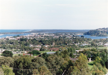
Photograph - Township, Tambo Shire, 1990c
... Waterways ...Also second copy photographic enlargements of significant sites in the Tambo ShireColor photograph of the township, showing a distant view of the Ninety Mile Beach, the Gippsland Lakes and islands, Kalimna Heights, the bridge over the North Arm, Cunninghame Arm, and a broad view of the town and tree lined streets. Lakes Entrance Victoriabridges, topography, township, waterways -
 Lakes Entrance Regional Historical Society (operating as Lakes Entrance History Centre & Museum)
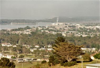
Photograph - Township, Fish Marie, 1985c
... Waterways ...Colour photograph of township, showing building on Bullock Island, Cunningham Arm and small white shed on old New Works Jetty near the entrance, view towards the barrier. Photo taken from near telecom tower on Merrangbaur Hill 1985c. Lakes Entrance Victoriatopography, township, waterways, bridges -
 Lakes Entrance Regional Historical Society (operating as Lakes Entrance History Centre & Museum)
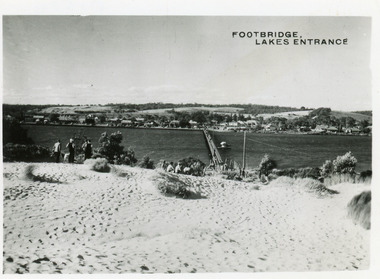
Postcard - Township, 1950c
... Waterways ...2 copies 6 x 9Black and white small format postcard of footbridge over Cunninghame Arm. It shows people on bare sand dunes in foreground boat moored beside bridge, motor vehicles parked along retaining wall on North shore with town buildings in background. Lakes Entrance VictoriaFootbridge Lakes Entrancebridges, waterways, township, people -
 Lakes Entrance Regional Historical Society (operating as Lakes Entrance History Centre & Museum)
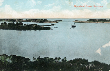
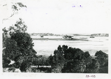
Photograph - The Entrance, 1910c
... Waterways ...Colour tinted photograph of the entrance from Bass Strait to the Gippsland Lakes. It shows the small village on the hummocks, Bullock Island with bathing boxes at western end, machinery building groyne's from Bullock Island. Boat in the water. Lakes Entrance VictoriaGippsland Lakes Entranceislands, ships and shipping, topography, waterways -
 Lakes Entrance Regional Historical Society (operating as Lakes Entrance History Centre & Museum)
Postcard - Township, 1930c
... Waterways ...Black and white small format postcard showing the township situated on the land between the Cunninghame Arm and North Arm. Lakes Entrance VictoriaLakes Entrance from Princes Highway (on back)bridges, township, topography, waterways -
 Lakes Entrance Regional Historical Society (operating as Lakes Entrance History Centre & Museum)
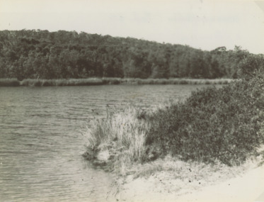
Photograph, Marie Fish, 1990c
... Waterways ...Colour photograph taken from Western shore looking upstream showing heavily timbered banks Lake Bunga Victoriabridges, forest, historic site, waterways -
 Lakes Entrance Regional Historical Society (operating as Lakes Entrance History Centre & Museum)
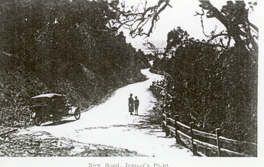
Photograph - Princes Highway Lakes Entrance, 1920c
... Waterways ...Black and white photograph of the newly formed Princes Highway. It shows the steep cutting into the Jemmys Point hill, the winding road, the post and rail fence, two people and car of the era on road. Lakes Entrance VictoriaNew Road Jemmy's Pointtopography, waterways, roads and streets, fences -
 Lakes Entrance Regional Historical Society (operating as Lakes Entrance History Centre & Museum)
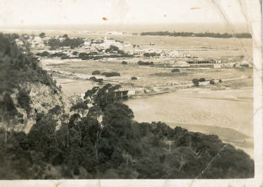
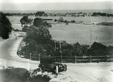
Photograph - Princes Highway Lakes Entrance, 1930c
... Waterways ...Black and white photograph of the Princes Highway as it winds around Jemmys Point. It shows a car parked in foreground, person on bicycle riding up hill, lake, Bullock Island and the township in distance. Lakes Entrance Victoria transport, roads and streets, waterways, township -
 Lakes Entrance Regional Historical Society (operating as Lakes Entrance History Centre & Museum)
Photograph - Lake Bunga, 1947
... Waterways ...Also identical photograph number 03842.1 size 8 x 10.5 cm also 03842.3Black and white photograph showing Eastern shore with heavily timbered background taken from Western shore Lake Bunga Victorialake bunga, waterways, forest, vegetation -
 Lakes Entrance Regional Historical Society (operating as Lakes Entrance History Centre & Museum)
Postcard - The Entrance, Cooper Alexander, 1910c
... Waterways ...Black and white large format postcard of the man made entrance to the Gippsland Lakes, it shows work in progress on the western pier of the entrance, Bullock Island, photo taken at low tide. Lakes Entrance VictoriaLakes Entrance Cunninghameislands, waterways, topography, ships and shipping -
 Lakes Entrance Regional Historical Society (operating as Lakes Entrance History Centre & Museum)
Photograph - Bullock Island, Fraser Ian, 1920c
... Waterways ...Black and white photograph of Bullock Island, showing Prince's Highway from North Arm bridge, east end of Bullock Island and bridge, entrance to Bass Strait and sand dunes along Cunninghame Arm. Western end of Bullock Island bridge raised to allow small boats access to North Arm and Cunninghame Arm, became known as Humpy Bridge. Lakes Entrance Victoria islands, waterways, topography, bridges -
 Lakes Entrance Regional Historical Society (operating as Lakes Entrance History Centre & Museum)
Postcard - Bullock Island, 1920c
... Waterways ...1 x Faded miniature postcard 6.5 x 8.5|1 x Black and white 9.5 x 12 copied from album in private hands|1 x Sepia toned 10 x 15|1 x Black and white 12 x 17.5Black and white small format postcard of Bullock Island. It shows the approaches to the concrete North Arm Bridge over North Arm, the footbridge to Bullock Island, the entrance to the Gippsland Lakes from Bass Strait and part of the township on the hummocks. Lakes Entrance VictoriaLakes Entrancewaterways, topography, islands, bridges -
 Lakes Entrance Regional Historical Society (operating as Lakes Entrance History Centre & Museum)
Photograph - Bullock Island, 1920 c
... Waterways ...Black and white photograph of Bullock Island. Steamer J C D passing Western end of Bullock Island. Lakes Entrance VictoriaLakes Entrancewaterways, islands, topography, shipping -
 Lakes Entrance Regional Historical Society (operating as Lakes Entrance History Centre & Museum)
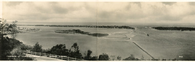
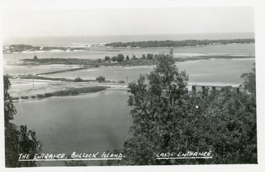
Postcard - Bullock Island, Bulmer H D No 15, 1930 c
... Waterways ...Black and white double size postcard of Bullock Island. It shows a glimpse of the Princes Highway in foreground, wooden foot bridge to Bullock Island, houses on the hummocks, entrance and Bass Strait in background, boat entering lakes. Lakes Entrance VictoriaPanorama of Lakes Entrance from Princes Highwaywaterways, islands, township, civil engineering -
 Lakes Entrance Regional Historical Society (operating as Lakes Entrance History Centre & Museum)
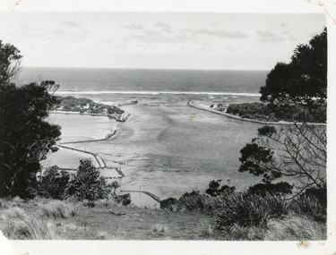
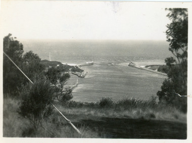
Photograph - The Entrance, 1930c
... Waterways ...Black and white photograph showing wooden piers at entrance to Bass Strait from the Gippsland Lakes. Buildings on sand dunes, Bullock Island and rock groynes. Photo taken from Jemmys Point showing shrubbery in foreground. Lakes Entrance Victoriawaterways, topography, boats and boating, islands -
 Lakes Entrance Regional Historical Society (operating as Lakes Entrance History Centre & Museum)
Photograph - The Entrance, 1930c
... Waterways ...Black and white photograph showing wooden piers at entrance to Bass Strait from the Gippsland Lakeswaterways, topography, boats and boating, islands -
 Lakes Entrance Regional Historical Society (operating as Lakes Entrance History Centre & Museum)
Photograph - The Entrance, 1930c
... Waterways ...Black and white photograph showing wooden piers at entrance to Bass Strait from the Gippsland Lakeswaterways, topography, boats and boating, islands -
 Lakes Entrance Regional Historical Society (operating as Lakes Entrance History Centre & Museum)
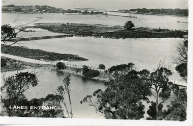
Postcard - Bullock Island, Bulmer H D, 1920c
... Waterways ...Hand coloured postcard of Bullock Island and the man made entrance from Bass Strait to the Gippsland Lakes. Also shown the small township, unofficially known as Carpentertown at the entrance works. Photo taken from Kalimna Hill, shrubbery in foreground. Lakes Entrance VictoriaBullock Island, Lakes Entrancewaterways, bridges, islands, jetties -
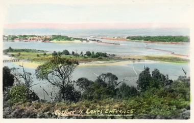
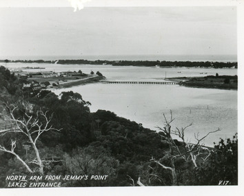 Lakes Entrance Regional Historical Society (operating as Lakes Entrance History Centre & Museum)
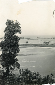
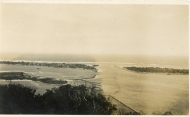
Postcard - North Arm, Valentine Series, 1930c
... Waterways ...This is the before paired photograph used in the 150 year Lakes Entrance 1858-2008 display.|The after paired photograph number is 01590.1 Also one 12 x 16 framed photograph used in room display.Black and white small format postcard of North Arm and Cunninghame Arm of Gippsland Lakes, taken from Jemmys Point, Club Hotel at western end of town, bridge to Bullock Island, scrub covered hummocks and Bass Strait in distance. Lakes Entrance VictoriaNorth Arm from Jemmys Point Lakes Entrancebridges, islands, waterways, topography -
 Lakes Entrance Regional Historical Society (operating as Lakes Entrance History Centre & Museum)
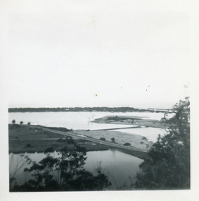
Postcard - Bullock Island, The Lakes Studio, 1920c
... Waterways ...One black and white copy 17 x 25Black and white postcard showing North Arm Bridge, Bullock Island and foot bridge northern end of piers at entrance to Bass Strait and sand dunes. Left foreground shows power pole and water bore and telephone poles along Princes Highway Lakes Entrance Victoria.The Entrance, Bullock Island, Lakes Entranceislands, bridges, waterways, topography -
 Lakes Entrance Regional Historical Society (operating as Lakes Entrance History Centre & Museum)
Photograph - Bullock Island, Scarce Keith, 1962
... Waterways ...Date made May 1962Colour photograph of Bullock Island. It shows the causeway and raised bridge to the island, Cunninghame Arm, dwellings and jetty at hummocks, western pier of entrance, sandy area of island planted with grass. Taken prior to transfer of PWD to island, and before Pecks factory and Fishermens Co-Operative. Lakes Entrance Victoriaislands, waterways, land reclamation, fishing industry -
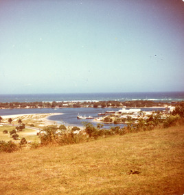 Lakes Entrance Regional Historical Society (operating as Lakes Entrance History Centre & Museum)
Photograph - Bullock Island, Fraser Ian, 1975c
... Waterways ...Color photograph of the eastern part of Bullock Island, showing buildings of Lakes Entrance Fishing Co-Operative and PWD, spit opposite Club Hotel has been sown with grass, hummocks and Bass Strait in distance. Taken from Seaview Parade Kalimna. Lakes Entrance Victoriawaterways, islands, land reclamation, topography -
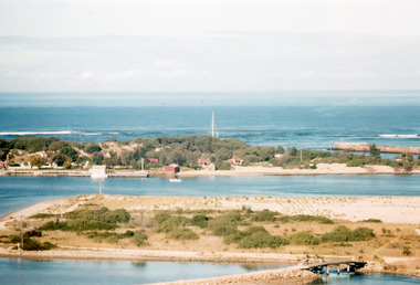
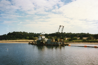 Lakes Entrance Regional Historical Society (operating as Lakes Entrance History Centre & Museum)
Photograph - Dredging, 1998
... Waterways ...Color photograph of Bullock Island. It shows the dredge Sandpiper working in Cunninghame Arm on the southern shore of Bullock Island. Dredged sand in background on island from previous dredging operations, Kalimna Heights and Jemmys Point in the background. Lakes Entrance Victoriaislands, waterways, public works, dredging -
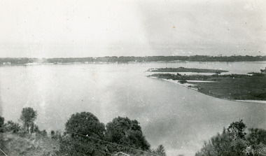
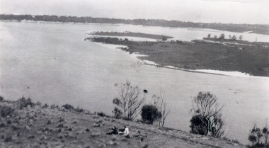 Lakes Entrance Regional Historical Society (operating as Lakes Entrance History Centre & Museum)
Photograph - Snake Island, 1930c
... Waterways ...Black and white photograph, showing eastern end of Rigby Island, Snake Island, at Lakes Entrance, Victoria. Reeves Channel below foreground hill, Hopetoun Channel between dunes and islands with fish pens in distance. Two people sitting on hill in foreground.islands, waterways, topography, room display -
 Lakes Entrance Regional Historical Society (operating as Lakes Entrance History Centre & Museum)
Photograph - Snake Island, 1930c
... Waterways ...Black and white photograph, showing eastern end of Rigby Island, Snake Island, at Lakes Entrance, VictoriaColour photograph, showing eastern end of Rigby Island, Snake Island, at Lakes Entrance, Victoriaislands, waterways, topography, room display -
 Lakes Entrance Regional Historical Society (operating as Lakes Entrance History Centre & Museum)
Photograph - Snake Island, 1930c
... Waterways ...Black and white photograph, showing eastern end of Rigby Island, Snake Island, at Lakes Entrance, VictoriaBlack and white photograph, showing eastern end of Rigby Island, Snake Island, at Lakes Entrance, Victoriaislands, waterways, topography, room display -
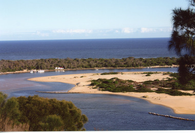
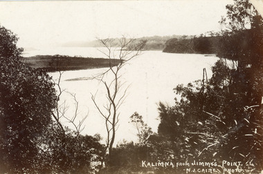 Lakes Entrance Regional Historical Society (operating as Lakes Entrance History Centre & Museum)
Postcard - Reeves Channel, Caire Nicholas John, 1905c
... Waterways ...Also black and white enlargement 16 x 25Black and white postcard of the lake below Jemmys Point, Gippsland Lakes, showing Rigby Island opposite the steep cliffs of Kalimna and Nungurner shores of lakes. Small island, known as the Doughboy of Rigby Island. View taken from Jemmys Point with natural vegetation in foreground. Lakes Entrance VictoriaKalimna from Jimmys Pointislands, waterways, topography, boats and boating -
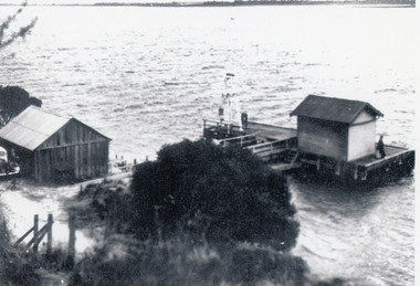 Lakes Entrance Regional Historical Society (operating as Lakes Entrance History Centre & Museum)
Photograph - Nungurner Jetty, 1938
... Waterways ...Reprinted from Rev. Alfred Maher's photo album, Anglican Church Archives, Sale, VictoriaBlack and white photograph of Nyerimilang Jetty, Gippsland Lakes. It shows a short jetty with boat landing, navigation light and storage shed on jetty, boatshed on bank. Small motor car beside boat shed. Distant view across lake to eastern point of Flanagan Island, Fraser Island and Rigby Island. Lakes Entrance Victoriajetties, boats and boating, waterways, topography -
 Lakes Entrance Regional Historical Society (operating as Lakes Entrance History Centre & Museum)
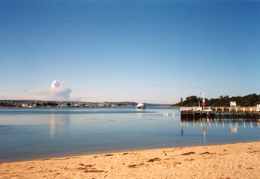
Photograph - Thunderbird, Holding M, 2000c
... Waterways ...Colour photograph of the township viewed from the southern shore of Cunninghame Arm at the New Works. New Works Jetty in mid foreground, tourist launch Thunderbird on lake. Smoke from a bushfire in distance. Reflections in calm waters of lake. Lakes Entrance Victoria tourism, waterways, township, boats and boating -
 Lakes Entrance Regional Historical Society (operating as Lakes Entrance History Centre & Museum)
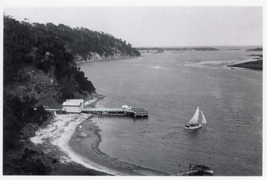
Postcard - Kalimna Jetty, Bulmer H D, 1920c
... Waterways ...Black and white postcard of Kalimna Jetty. It shows a jetty with painted railings, storage shed with square water tank, low lying shore of lake in foreground contrasting with steep cliffs beyond jetty. Boat moored at a small jetty in foreground, yacht sailing from jetty, glimpse of Rigby Island and Bullock Island and the New Works area in distance. Lakes Entrance Victoriajetties, waterways, islands, boating