Showing 27615 items
matching yarra-river
-
 Malmsbury Historical Society
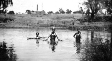
Photograph (Item), B/W Children Swimming In Coliban River, Malmsbury c1934
Buildings - "Coliban River, Mill" -
 Stawell Historical Society Inc
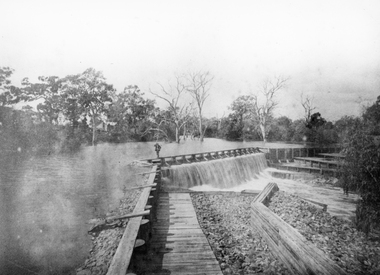
Photograph, Wimmera River Weir at Glenorchy
Wimmera River Weir Glenorchywater -
 Melbourne Tram Museum
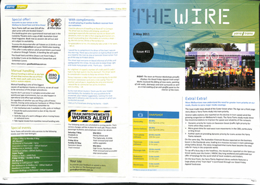
Magazine, Yarra Trams, "The Wire", 5/2011 to 1/2015
0 - No 9 - 1/4/2011 - Rhinos on skateboards, Did you know, Spencer St works, .1 - No. 11 of 3/5/2011 with the revised Yarra trams logo, traffic priority, work over Easter in Spencer St at Bourke and Collins St, Good Friday appeal, safety, passenger feedback and future works. .2 - No. 13 - 31/5/2011 - new uniform, cleaning, CEPR, trackwork - Fitzroy St, Northcote, Rhino, Carlton Control. .3 - No. 14 - 15/6/2011 - Haymarket Roundabout, accessibility, maintenance, CSE. .4 - No. 17 - 2/8/2011 - High St Westgarth trackwork, Swanston St, IMF CEO visit .5 - No. 18 - 16/8/2011 - Performance benchmarks met, Preston Workshops, repairs to 3018, tram signal priority. .6 - No . 19 - 30/8/2011 - New E class trams, routes "a" or "d", TramTracker in shelters, police, fare evasion .7 - No. 20 - 15/9/2011 - Football trams, Superstops, Bridge Road, Rhinos. .8 - No. 21 - 27/9/2011 - CEO's journey to work, accessibility, increased patronage, E class. .8a - No. 22 - 11/10/2011 - Minister Mulder visit, E class, Customer experience, Elizabeth Kerdelhue Corporate Affairs Director, flood indicator in Wellington Parade, Keolis - Orleans and PTV coming your way. .9 - No. 23 - 25/10/2011 - forthcoming royal visit, opening for Footscray Road extension, Rhinos, Stockholm .10 - No. 24 - 8/11/2011- Royal visit, photos, Z3 158, route 86 works in High St. (see htd5043i21 for a image from an unknown newspaper of the actual event - features Z3 158.) .11 - No. 25 - 22/11/2011 - new staff guide, Gold Coast tram line, Macarthur St, overhead, fund raising, route numbering update. .12 - No. 26 - 6/12/2011 - Swanston St Superstops, Newmarket bridge strikes, rhinos. .13 - No. 27 - 20/12/2011 - Christmas carnival, Lenny Bates, portable crossover, uniforms. .14 - No. 28 - 17/1/2012 - Passing of Len Bates, Myki, Gardiner railway station. .15 - No. 30 - 15/2/2012 - visit of Keolis, SNCF people, list of Executive leadership team with photos, Swanston St works, Myki introduction. .16 - No. 31 - 29/2/2012 - patronage up, tram postage stamps, Myki, rhinos. .17 - No. 32 - 14/3/2012 - St Kilda Rd trackwork, fund raising, Southbank Depot extensions, Myki, driving conditions, grand prix. .18 - No. 33 - 30/3/2012 - introduction of the PTV, end of MetLink and Transport Ticketing Authority, changes in management structure, trackwork, Gold Coast tramway and Keolis. .19 - No. 34 - Dr Jake - Royal children's Hospital super stop, route 96 - Premium line. .20 - No. 35, 2/5/2012 - Revision of Rules, trackwork in St Kilda Road and Elizabeth St, Myki, safety - Zero Harm. .21 - No. 69 - 25/9/2013 - Passengers paying their way, E class update, Mal Ashworth retires, progress report, feedback, new chime on trams. .22 - No. 70 - 9/10/2013 - Art comes alive, tram 925, driver simulator at Preston Workshops, E class project, 90th Glen Huntly. .23 - No. 83 - 23/4/2014 - Screen time for trams, new PIDs on B class, assistance animals, Operations Centre, Preston Workshops, Electrical log sheets to SLV. .24 - No. 89 - 23/7/2014 - punctuality, refresh of network map (fold-out map), women drivers. .25 - No. 97 - 19/11/2014 - Revitalising route 96, Keolis news, free tram zone, guide dogs. .26 - No. 99 - 17/12/2014 - Accessibility week, new uniform top for CSE's, free tram zone, world trade centre stop upgrade, heat stress, Art tram 158. .27 - No. 100 - 14/1/2015 - Route 96 complete, New Years eve free travel, fare compliance, patronage down, Demonstrates Yarra trams staff newsletters.Set of 22 Yarra Trams internal newsletter "The Wire", All A4, printed in full colour. All four pages unless noted otherwise, full colour, performance snapshot on front cover.trams, tramways, yarra trams, traffic control, trackwork, spencer st, fund raising, operations, rhinos, carlton control, high st, haymarket, preston workshops, e class, route numbers, bridge road, wellington parade, ptv, royal visit, footscray road, new tramway, gold coast, macarthur st, swanston st, superstops, newmarket, gardiner, burke road, level crossings, railway squares, myki, metlink, tickets, route 96, rules, st kilda road, elizabeth st, tram 158, tram 925, glen huntly depot, simulator, b class, opeations centre, art trams, patronage -
 Eltham District Historical Society Inc
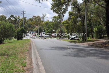
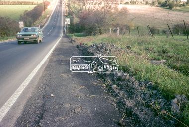
Photograph, Barry Philp, Eltham-Yarra Glen Road, Research, Vic, c.2013
View looking north along Eltham-Yarra Glen Road towards intersection with Research-Warrandyte Road and Research shops, c.2013eltham-yarra glen road, main road, research (vic.), research shops, research-warrandyte road -
 Eltham District Historical Society Inc
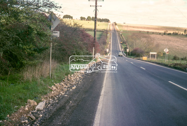
Slide - Photograph, Eltham-Yarra Glen Road, Kangaroo Ground, c.May 1988
Looking south along Eltham-Yarra Glen Road towards intersection with Kangaroo Ground-Warrandyte Road, Kangaroo Ground, May 198835mm colour positive transparency (1 of 36) Mount - Kodak KodachromeProcess Date MAY 88Minfrastructure, roads, eltham-yarra glen road, kangaroo ground, kangaroo ground-warrandyte road -
 Eltham District Historical Society Inc
Slide - Photograph, Eltham-Yarra Glen Road, Kangaroo Ground, c.May 1988
Looking south along Eltham-Yarra Glen Road towards intersection with Kangaroo Ground-Warrandyte Road, Kangaroo Ground, May 198835mm colour positive transparency (1 of 36) Mount - Kodak KodachromeProcess Date MAY 88Minfrastructure, roads, eltham-yarra glen road, kangaroo ground, kangaroo ground-warrandyte road -
 Wonga Park Community Cottage History Group
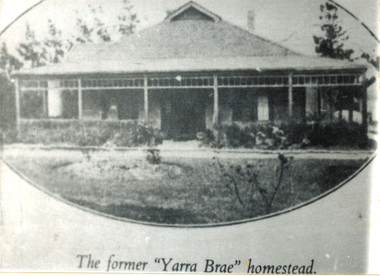
Photograph (sub-item) - The Yarra Brae homestead in 1940, which was burnt down in the early 1970’s. A ripple iron house
The Yarra Brae homestead in 1940, which was burnt down in the early 1970’s. A ripple iron house. since been rebuilt and altered. -
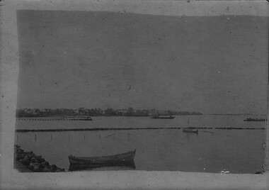
 Port Fairy Historical Society Museum and Archives
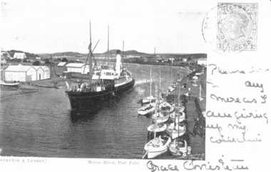
Photograph - Photographic postcard, S.S.Casino in Moyne River 1905
This postcard features the S.S.Casino steaming into the Moyne river at Port Fairy after turning around in a "turning basin" situated further up the river it would then berth and disembark passengers and cargo onto the wharfPostcard featuring a photograph of S.S.Casino 1904 written on and stampedship, boat, sea, moyne river, s.s.casino, belfast and koroit steam navigation company -
 Melbourne Tram Museum
Document - Folder, Yarra Trams, 2006
.1 Folder from white card, folded to provide folder for storing papers in, with the Yarra Trams logo in the top left hand corner, "Melbourne all over", an stylised image of a tram in the bottom right hand corner and Yarra trams web address on the rear. Has various Melbourne aspects or locations on the inside cover. .2 - Folder reversed with the alternative viewpoint in presentation..1 - On the top right hand "100 years" in ink.trams, tramways, centenary, yarra trams, 100 years of electric trams, melbourne -
 Melbourne Tram Museum
Ephemera - Calendar, Yarra Trams, 2006
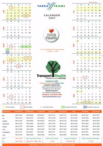
Printed A4 calendar on gloss paper, full colour providing dates for 2007 including public and school holidays, Grand Prix, 12th Fina World Championships, Pay weeks and Daylight saving, phone numbers for contacts at each depot, Yarra Trams logo, Yarra Trams "Love your trams" badge and Transport Health Insurance details. Two copies held.trams, tramways, yarra trams, calendar -
 Melbourne Tram Museum
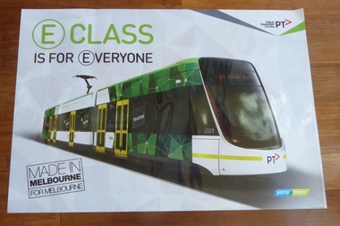
Poster, Yarra Trams, "E class is for Everyone", 2014
Full colour poster printed on a vinyl plasticized based sheet, titled "E class is for Everyone", with a large image of E class No. 6001 for use in "Snapper" frames at Yarra Trams tram stops. Has the Yarra Trams and Public Transport Victoria (PTV) logos and the words "Made in Melbourne". 624.1 - vertical format of the same poster. See image htd.624i2trams, tramways, e class, yarra trams, ptv, tram stops, tram 6001 -
 Marysville & District Historical Society
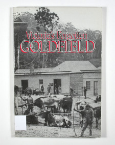
Book - Paperback book, Victoria's Forgotten Goldfield-A History of the Dargo, Crooked River Goldfield, 1996
A history of the Dargo, Crooked River goldfieldPaperback. Cover has a black and white photograph of a couple of buildings surrounded by forest. Photograph is probably of Dargo. One building has a sign that says S. Frankenberg. Another has a sign of which only the letters PION visible. In the photograph there are a number of men standing around the buildings as well as what appears to be two children sitting on a bench outside a building. There is also a large wagon-like vehicle to which is attached are a large train of oxen. In the foreground of the photograph is another group of oxen which appear to be chained together. There is also two men standing near the second group of oxen, both appear to be holding whips.The stamp of the Marysville & District Historical Society Inc / P.O. Box 22 / Marysville 3779gold, gold mining, gold town, dargo, gold miner, gold field, gippsland, victoria, australia, history -
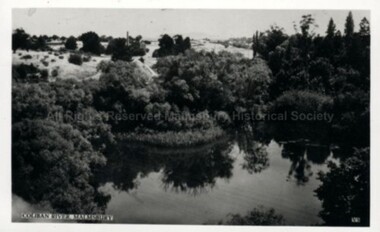 Malmsbury Historical Society
Postcard (Item), Railway Viaduct Over Coliban River At Malmsbury, Malmsbury ca1940
Buildings - Coliban River & Malmsbury Mill -
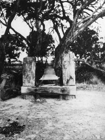 Stawell Historical Society Inc
Photograph, Wooden Footbridge over the river in Glenorchy
Glenorchy Wooden Footbridge over Riverstawell -
 Eltham District Historical Society Inc
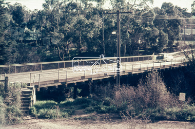
Slide - Photograph, Russell Yeoman, Para Road / Carter Street Bridge over the Plenty River, Briar Hill, c.Jul 1969
Bridge over the Plenty River at Briar Hill before widening and alterations. The Plenty River at Briar Hill represented the boundary between the Shire of Eltham and the Shire of Diamond Valley. The bridge was known as the Carter Street Bridge as prior to 1969 Para Road, Briar Hill became Carter Street, Greensborough across the river. It was at this time that the name Para Road was continued and replaced Carter Street.35mm colour positive transparency blue Agfacolour Service plastic mount1969-07, briar hill, carter street bridge, para road, para road bridge, shire of diamond valley, shire of eltham, bridge, plenty river, shire of eltham pioneers photograph collection -
 Eltham District Historical Society Inc
Negative - Photograph, Russell Yeoman, Para Road / Carter Street Bridge over the Plenty River, Briar Hill, c.Jul. 1969
Bridge over the Plenty River at Briar Hill before widening and alterations. The Plenty River at Briar Hill represented the boundary between the Shire of Eltham and the Shire of Diamond Valley. The bridge was known as the Carter Street Bridge as prior to 1969 Para Road, Briar Hill became Carter Street, Greensborough across the river. It was at this time that the name Para Road was continued and replaced Carter Street.This photo forms part of a collection of photographs gathered by the Shire of Eltham for their centenary project book,"Pioneers and Painters: 100 years of the Shire of Eltham" by Alan Marshall (1971). The collection of over 500 images is held in partnership between Eltham District Historical Society and Yarra Plenty Regional Library (Eltham Library) and is now formally known as the 'The Shire of Eltham Pioneers Photograph Collection.' It is significant in being the first community sourced collection representing the places and people of the Shire's first one hundred years.Digital image 35 mm B&W negativeshire of eltham pioneers photograph collection, briar hill, 1969-07, bridge, carter street bridge, para road, para road bridge, plenty river, shire of diamond valley, shire of eltham -
 Melbourne Tram Museum
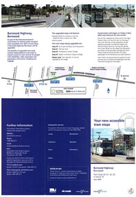
Pamphlet, Yarra Trams, "Your new accessible tram stops", Apr. 2007
Set of five Pamphlets - DL - 3 fold, full gloss paper titled "Your new accessible tram stops" about the introduction in April 2007 of upgrades stops in Burwood Highway - stops 59, 61, 62, and 63 to Superstops. Has VicRoads logos as well as Vic Government and Yarra Trams. Two copies held. 1 -2 fold DL - for stops 124A on routes 96, 109, and 112 - on the Specert St Bridge over the Yarra River - has map. 2 - 3 fold DL for stops 38, 42, 48 and 52 Dandenong Road - Nov. 2007 3 - 3 fold DL for stops 22, 23, 24 and 26 Queens Parade Fitzroy North, Nov. 2008 4 - 3 fold DL for stops 53 to 59 - Matthews Ave Airport West April 2008trams, tramways, yarra trams, burwood, vermont south, superstops, route 75, spencer st, route 96, route 109, route 112 -
 Lakes Entrance Regional Historical Society (operating as Lakes Entrance History Centre & Museum)
Photograph, 1953
Black and white photograph taken at the marriage of Hector Burchell to Ina Eaton nee Carstairs with Inas parents Emily and David Carstairs at St Andrews Presbyterian Church South Yarra South Yarra Victoriacaravan parks, tourism -
University of Melbourne, Burnley Campus Archives
Photograph - Black and white print, 76/5, 1947
Looking South towards River Yarra.garden views, e. m. gibson collection -
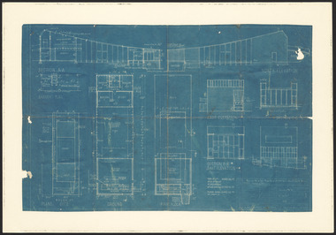 Robin Boyd Foundation
Drawing - Architectural, Robin Boyd, 290 Walsh Street South Yarra, 1958
Project: House for Mr and Mrs Robin Boyd, 290 Walsh Street South Yarra drawn by Robin Boyd of Robin Boyd, Grounds Romberg & Boyd.Working Drawing, Blueprint -
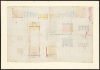 Robin Boyd Foundation
Drawing - Architectural, Robin Boyd, 290 Walsh Street South Yarra, 1958
Project: House for Mr and Mrs Robin Boyd, 290 Walsh Street South Yarra drawn by Robin Boyd of Robin Boyd, Grounds Romberg & Boyd.Working Drawing, Colour copy, very faded. -
 Greensborough Historical Society
Slide - Photograph, John Ramsdale, Plenty River: Slide 104, 1990s
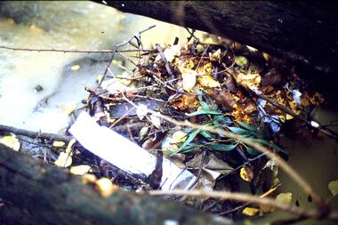
Photograph shows a riverbank with rubbish on the Plenty River.Part of the John Ramsdale collection of slides and audio visual material.Colour photograph scanned from slide.No maker's marks. No caption on slide.plenty river, pollution -
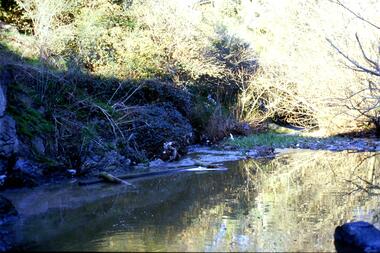
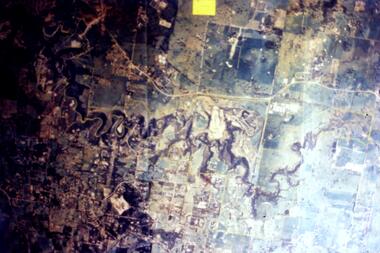 Greensborough Historical Society
Slide - Photograph, John Ramsdale, Aerial view of Plenty River: Slide 16, 1990s
Photograph shows aerial view of the Plenty River.Part of the John Ramsdale collection of slides and audio visual material.Colour photograph scanned from slide.No maker's marks. No caption on slide.plenty river, aerial photograph -
 Greensborough Historical Society
Slide - Photograph, John Ramsdale, Rubbish in Plenty River: Slide 58, 1990s
Photograph shows leaf mulch in Plenty River.Part of the John Ramsdale collection of slides and audio visual material.Colour photograph scanned from slide.No maker's marks. No caption on slide.plenty river -
 Greensborough Historical Society
Photograph - Digital image, Charles Marshall et al, Nile River or Port, 1917-1918
This photograph shows either the Nile River or a Port.Digital copy of black and white photograph. This photo has no caption.charles marshall, world war 1 -
 Malmsbury Historical Society
Photograph (Item), "Group Camping On Coliban River Malmsbury, Townsend", Malmsbury c1900
People - "Townsend, Edward" Buildings - "Tent, River" -
Malmsbury Historical Society
Photograph (Item), Cleaning Coliban River At Malmsbury, Malmsbury ca2003
Buildings - River People - "Tynan, Alexandra (Photographer)" -
Malmsbury Historical Society
Photograph (Item), Cleaning Coliban River At Malmsbury, Malmsbury ca2003
Buildings - River People - "Tynan, Alexandra (Photographer)" -
Malmsbury Historical Society
Photograph (Item), Cleaning Coliban River At Malmsbury, Malmsbury ca2003
Buildings - River People - "Tynan, Alexandra (Photographer)"