Showing 110315 items matching "roads"
-
 Ringwood and District Historical Society
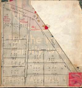
Map, Subdivision Plan of residential allotments on Canterbury Road, Bayswater (later surrounding Miller Road, Heathmont), Victoria - (Undated - circa 1930s)
Hand-drawn map on cardboard backing. Includes red pen notations marking allotments sold to Mrs A. Harrison, Mrs C Cornwall, J.M. Miller, and A.W. Dickson.Red pen notations mark allotments sold to Mrs A. Harrison, Mrs C Cornwall, J.M. Miller, and A.W. Dickson. Later subdivision of the map area took in Miller Road and Atunga Court developments. -
 Clunes Museum
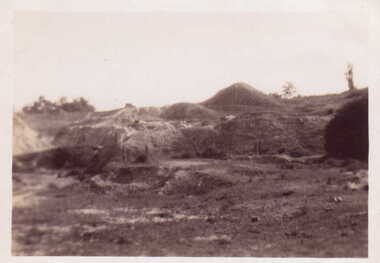
Photograph, 1939
THIS PHOTOGRAPH IS OF PORT PHILLIP MINE CLUNES. VIEW OF MULLOCK HEAPS.BLACK AND WHITE PHOTOGRAPH OF MULLOCK HEAPS OF PORT PHILLIP MINE AT CLUNES.ON REVERSE: HANDWRITTEN IN BLUE BIRO "MULLOCK HEAPS CLUNES 1939" ON REVERSE: HANDWRITTEN IN LEAD PENCIL "15" AND "20"" ON REVERSE: PURPLE STAMPED "ALLAN H. MANSELL CHEMIST, 213 GLENFERRIE ROAD GLENFERRIE"local history, photography, photographs, mining -
 Bendigo Military Museum
Weapon - BOMB, AERIAL 1000 LB, C.1943
This item is situated in the gardens of the Bendigo District RSL Sub Branch Inc Havilah Road Bendigo.Bomb 1000 lb Aerial, metal construction, cylindrical shape, on top are two lifting lugs, rear tapers down with 4 fins inside a circular cover, the nose tapers sharply then forms a smaller impact point. Item is on a stand.On side of the bomb, “No.37 - IMC 1000 LB R&M 9/43”bdrslinc, smirsl, brsl, bomb, 1000 -
 Eltham District Historical Society Inc
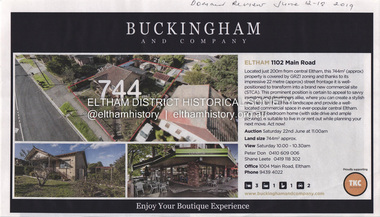
Document - Property Binder, 1102 Main Road, Eltham
Newspaper advertisement: Domain Review, 12-18 June 2019, Sale of 1102 Main Road.main road, eltham, property, shops, buckingham and company estate agent -
 Eltham District Historical Society Inc
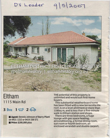
Document - Property Binder, 1115 Main Road, Eltham
Newspaper advertisement: Diamond Valley Leader, 9 May 2007, Sale of 111 Main Road.main road, eltham, property -
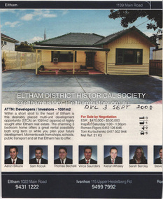 Eltham District Historical Society Inc
Document - Property Binder, 1139 Main Road, Eltham
Newspaper advertisement: Diamond Valley Leader, 3 September 2008, sale of 1139 Main Road.main road, eltham, property -
 Eltham District Historical Society Inc
Document - Photocopy, Survey Fleld Notes of Part of Crown Portion 13, Section 4 at Eltham, Parish of Nillumbik, County of Evelyn, 1902-1903
Main Road, Henry Street to Diamond Street; Silver Street to Bible Street Application No. 0337771902, 1903, arthur street, bible street, bird street, diamond creek (creek), diamond street, eltham, eltham railway station, henry street, main road, silver street, survey plan, vine street, application 33777, map -
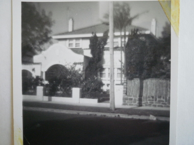 Glen Eira Historical Society
Photograph - St. Georges Road, 36, Elsternwick
A black and white photograph, undated, of the house at 36 St. Georges Road, Elsternwick, named Aloha.photographs, house names, st. georges road, aloha, elsternwick, houses -
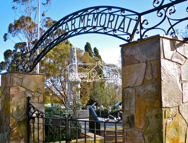 Eltham District Historical Society Inc
Photograph, Jim Connor, Main Road, Eltham, 11 Aug 2015
The Cenotaph viewed through the Eltham War Memorial Gate, 905-907 Main Road, ElthamTomorrow's history documented todayeltham, jim connor collection, main road, eltham cenotaph, eltham war memorial, eltham war memorial gate, obelisk -
 Eltham District Historical Society Inc
Photograph, Jim Connor, Avenue of Honour, Main Road, Eltham, 14 Jan 2017
Eltham Gateway, Eltham Clinic, 700 Main Road, Elham viewed from Dalton StreetTomorrow's history documented todayeltham, jim connor collection, main road, avenue of honour, eltham gateway, dalton street, eltham clinic -
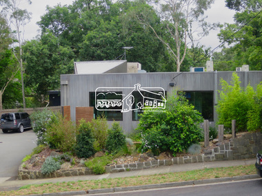
 Eltham District Historical Society Inc
Photograph, Jim Connor, Avenue of Honour, Main Road, Eltham, 14 Jan 2017
Eltham Gateway, Local History Centre, 728 Main Road, Eltham at intersection of Brougham Street Tomorrow's history documented todayeltham, jim connor collection, main road, eltham gateway, avenue of honour, brougham steet, local history centre -
 Eltham District Historical Society Inc
Photograph, Jim Connor, Main Road, Eltham, 14 Jan 2017
Eltham Gateway, Former CBA Bank and Opportunity Shop, near 804 Main Road, ElthamTomorrow's history documented todayeltham, jim connor collection, main road, eltham gateway, cba bank, opportunity shop -
 Eltham District Historical Society Inc
Photograph, Jim Connor, Main Road, Eltham, 14 Jan 2017
Eltham Gateway, Unit complex at 72-74 Bridge Street, Eltham at corner of Main RoadTomorrow's history documented todayeltham, jim connor collection, main road, eltham gateway, bridge street -
 Eltham District Historical Society Inc
Photograph, Jim Connor, Main Road, Eltham, 14 Jan 2017
Eltham Gateway, Shillinglaw Cafe viewed from near intersection of Main Road and Panther PlaceTomorrow's history documented todayeltham, jim connor collection, main road, eltham gateway, panther place, shillinglaw cottage -
 Eltham District Historical Society Inc
Photograph, Jim Connor, Main Road, Eltham, 14 Jan 2017
Eltham Gateway, Unit complex at 72-74 Bridge Street, Eltham at corner of Main RoadTomorrow's history documented todayeltham, jim connor collection, main road, eltham gateway, bridge street -
 Eltham District Historical Society Inc
Photograph, Jim Connor, Main Road, Eltham, 14 Jan 2017
Eltham Gateway, Unit complex at 72-74 Bridge Street, Eltham at corner of Main RoadTomorrow's history documented todayeltham, jim connor collection, main road, eltham gateway -
 Eltham District Historical Society Inc
Photograph, Jim Connor, Main Road, Eltham, 14 Jan 2017
Eltham Gateway, Telstra Telephone Exchange, 800 Main Road, Eltham at intersection of Pitt StreetTomorrow's history documented todayeltham, jim connor collection, main road, eltham gateway, pitt street, telephone exchange -
 Eltham District Historical Society Inc
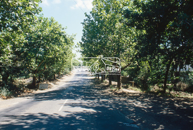
Slide, Main Road, Eltham South, Nov. 1981
Roll of film taken by Eltham Shire Council officers (Nov. 1981) reflecting road infrastructure.35 mm colour positive transparency (1 of 27) Mount - Kodak Ektachrome CardProcessed 18 Jan 1982avenue of honour, eltham, main road -
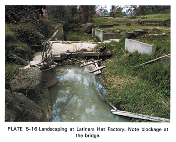 Eltham District Historical Society Inc
Work on paper (Sub-Item) - Photograph, Landscaping at Latiners Hat Factory
Colour photograph of Landscaping at Latiners Hat Factory, Sherbourne Road, Eltham. Note blockage at the bridgeeltham, drain, latiners, hat factory, landscaping, footbridge, blockage -
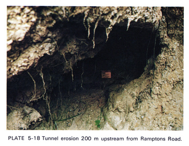 Eltham District Historical Society Inc
Work on paper (Sub-Item) - Photograph, Tunnel erosion 220 m upstream from Ramptons Road
Colour photograph of tunnel erosion 220 metres upstream from Ramptons Road, Eltham North eltham, erosion, eltham north, drain -
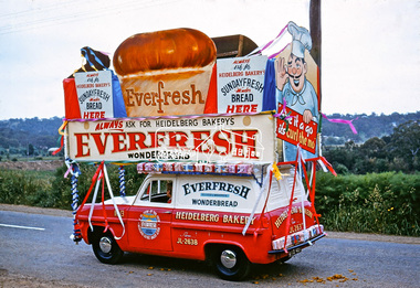 Eltham District Historical Society Inc
Photograph, Heidelberg Bakery display, Ersilac Parade, Main Road, Eltham, c.1960, 1960c
Heading south along Main Road approaching Bridge Street. Registration GIB is c.1955Digital file only (Wes's 35mm)don muir collection, heidelberg bakery display, ersilac parade, main road, eltham, c.1960 -
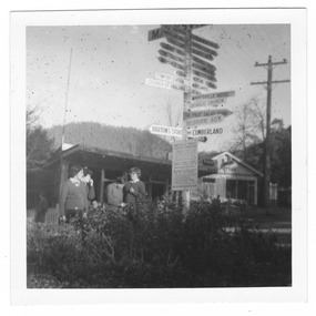 Marysville & District Historical Society
Photograph (Item) - Black and white photograph, 05-1960
A black and white photograph of the sign post that once stood opposite Pack Road in Marysville in Victoria.A black and white photograph of the sign post that once stood opposite Pack Road in Marysville in Victoria. This corner was known as Signpost Corner.marysville, victoria, sign post, signpost corner, pack road -
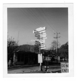 Marysville & District Historical Society
Photograph (Item) - Black and white photograph, Unknown
A black and white photograph of the sign post that once stood opposite Pack Road in Marysville in Victoria.A black and white photograph of the sign post that once stood opposite Pack Road in Marysville in Victoria. This corner was known as Signpost Corner.marysville, victoria, sign post, signpost corner, pack road -
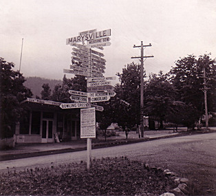 Marysville & District Historical Society
Photograph (Item) - Black and white photograph, Unknown
A black and white photograph of the sign post that once stood opposite Pack Road in Marysville in Victoria.A black and white photograph of the sign post that once stood opposite Pack Road in Marysville in Victoria. This corner was known as Signpost Corner.marysville, victoria, sign post, signpost corner, pack road -
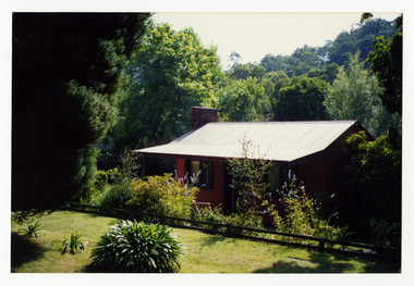 Marysville & District Historical Society
Photograph (Item) - Colour photograph, Unknown
A colour photograph of a small house that was once situated on the corner of Pack and Falls Roads in Marysville in Victoria.A colour photograph of a small house that was once situated on the corner of Pack and Falls Roads in Marysville in Victoria. This house was once known as Oxley House and was destroyed in the 2009 Black Saturday bushfires.pack road, falls road, marysville, victoria, oxley house, 2009 black saturday bushfires, photograph -
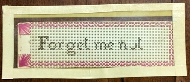 Phillip Island and District Historical Society Inc.
Bookmark, Human hair cross stitch bookmark, Circa mid 1800s
Owned by Charles Mc Gregor in 1866, Pyramid Rock Road. Donated by G W GliddonNeedlework. Cross stitch bookmark on perforated board. Black stitches-possibly human hair- with red border. Enclosed in carboard and plasticForget me not "words on the bookmark are made with human hair according to Jessie's story, which is doubtless correct. The writer remembers similar things being done with hair inthe 1890s" JWG [ J W Gliddon] 1970charles mcgregor, needlework, j w gliddon -
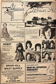 Greensborough Historical Society
Photograph - Advertisement - Digital Image, Diamond Valley News, Briar Hill shops 1978, 1978
Full page advertisement for the Briar Hill shops, corner Mountainview and Sherbourne Roads Briar Hill.Digital copy of newspaper advertisementbriar hill, briar hill shops, mountainview road briar hill, sherbourne road briar hill -
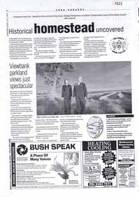 Greensborough Historical Society
Article - Newspaper Clipping (copy), Heidelberg Leader, Historical homestead uncovered, 09/07/2002
Articles on discovery of the site of Viewbank homestead; wheat silos next to Banyule Road, and Viewbank parklandsTwo photocopied pages of newspaper articlesviewbank, banyule road viewbank, silos, viewbank homestead -
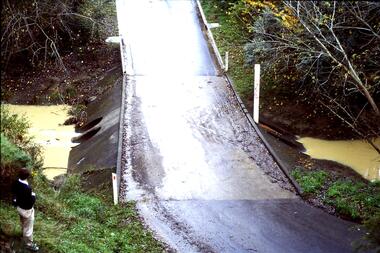 Greensborough Historical Society
Slide - Photograph, John Ramsdale, Ford over Plenty River to Partington's Flat: Slide 72, 1990s
Photograph shows road or path over culvert. This is the ford over Plenty River to Partington's FlatPart of the John Ramsdale collection of slides and audio visual material.Colour photograph scanned from slide.No caption. Printed maker's mark on slide "Kodak Kodachrome Slide"ford over plenty river, plenty river, partington's flat