Showing 2286 items matching " parish."
-
 Geelong Cycling Club
Memorabilia - Pennant, 1961
Junior competition was important for the future of the Club. Here Don Wilson would go on to win Australian Championships in both Amateur and professional spheres and to represent Australia in Olympic and Commonwealth Games.Record of importance of Juniors to Club life.Triangular pennant in blue felt. The pennant is trimmed with white felt and has details of the race and the winners stamped in white on it."VACU/Premiership/c/B. Murrell/L. Parish/D. Wilson/G. Hanson/F. Williams/Time 38.206"vacu; geelong cycling club; gcc; country junior teams; 15 miles road premiership; 1961; b. murrell; l. parish; d. wilson; g. hanson; f. williams; -
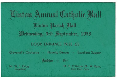 Linton and District Historical Society Inc
Ticket, Linton Annual Catholic Ball, 1958, 1958
Dark green card, black printing. Ticket for Linton Annual Catholic Ball, held 3rd September 1958.Text: " Linton Annual Catholic Ball / Linton Parish Hall / Wednesday, 3rd September, 1958 / DOOR ENTRANCE PRIZE. "linton catholic church, events, balls, w. s. grigg, f. o'beirne, w. ryan -
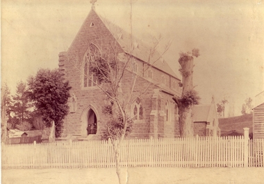 Clunes Museum
Photograph, ST THOMAS AQUINAS CHURCH, 9/06/1974
ST. THOMAS AQUINAS CHURCH, CLUNES WAS OPENED IN 1974SEPIA PHOTOGRAPH OF ST. THOMAS AQUINAS CHURCH, CLUNES.ST. THOMAS AQUINAS CHURCH CLUNES. CENTENARY CELEBRATION OF OPENING OF CHURCH AND FORMING OF PARISH. SUNDAY, 9 JUNE 1974.local history, photography, photographs, churches, roman catholic -
 Stawell Historical Society Inc
Book - Family History, John Lewis, Mad, Bad, and Dangerous to know. A History of the Byron Family, 1992
A History of the Byron Family. Title from quote of poet Lord Byron - self Description.Soft cover. BlueAshton Parish Church 1281 - 1981 in black circle drawing of church inside. circle below church 700 yearsfamily history -
Bendigo Historical Society Inc.
Map - CAMPBELL COLLECTION: BENDIGO AND DISTRICT MAPS, 23-4-29
Map. Whirrakee, Parish of Whirrakee, Total area 4419 acres, scale 20 chains to 1 inch. Unused water race in centre of map. Eucalypt Oil Distillery, bottom of map. Prepared in W.P.B. from Assessor's Plan and Parish Plan. G.W.Latimer 23-4-29. (number 385 in map cupboard 1)G.W.Latimermap, bendigo, agricultural lands -
Bendigo Historical Society Inc.
Map - CAMPBELL COLLECTION: BENDIGO AND DISTRICT MAPS
Map. Ascot, Parishes of Huntly, Sandhurst and Wellsford. Scale 20 chains to 1 inch. Total area 2818 acres. To Bendigo 4 1/2 miles, to Epsom 3/4 mile, Huntly 3/4 mile. Prepared in W.P.B. from Assessment Plans and Parish Plans. (number 380 in map cupboard 1)map, bendigo, agricultural lands -
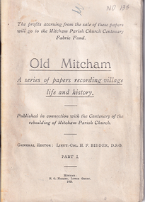 Whitehorse Historical Society Inc.
Book, Old Mitcham, 1923
Some essays on the history of Mitcham,Some essays on the history of Mitcham, Surrey, England published in connection with the centenary of the rebuilding of the Parish Church, 1.The Mitcham Parish Church which dates from 1291. It had been rebuilt several times most recently in 1922. 2.Memories of Mitcham written in 1911, the main occupation being herb growing. 32 pages.Some essays on the history of Mitcham,mitcham, surrey, england -
Port Melbourne Historical & Preservation Society
Plan - Port Melbourne, 1882
Large, deteriorated 1882 plan of Port Melbourne, Parish of South Melbourne, County of Bourke - showing Town Lots. Pasted onto board.town planning, fishermans bend, sandridge lagoon, transport - railways -
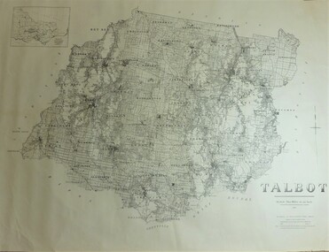 Bendigo Historical Society Inc.
Map - JACK FLYNN COLLECTION: TALBOT, 1937
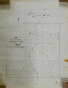
Map: County of Talbot, map sheet showing the whole of the County of Talbot and all of the Parishes within. Scale 2 Miles to 1 inch.By Authority: A.C. Brooks, Government Printer, Melbourne. Department of Lands and Survey Melbourne. 1959map, talbot, county, talbot -
 Bendigo Historical Society Inc.
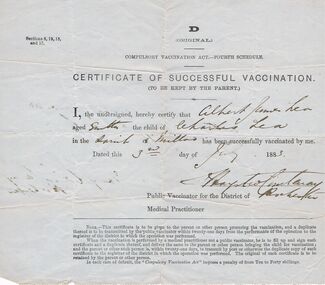
Document - LEA FAMILY COLLECTION: DOCUMENT
Certificate of Vaccination for Albert James Lea aged 8 months. Child of Charles Lea in the Parish of Milloo. Public Vaccinator for the District of Rochester.person, certificate, vaccination certificate, lea family documents, certificate of successful vaccination, albert james lea, charles lea -
Bendigo Historical Society Inc.
Map - PART PARISHES OF MARONG AND LOCKWOOD, No date visible
Map: Section of Parish plan of Bendigo, covering Kangaroo Flat, Golden Square, and Specimen Hill ( number 146 in Map Cupboard 1)Map 10map, bendigo, city streets, parish of marong, parish of lockwood, kangaroo flat, golden square, specimen hill -
Bendigo Historical Society Inc.
Map - PARISH OF HUNTLY(PART) AND SANDHURST(PART), No date visible
Map: Part of parish plan of Bendigo, covering Strathdale, White Hills, Huntly and North Bendigo ( number 144 in Map Cupboard 1)map, bendigo, city streets, parish of hunlty, parish of sandhurst, strathdale, white hills, huntly, north bendigo -
Bendigo Historical Society Inc.
Map - SANDHURST (PART), No date Visible
Map: Hand Draughted parish plan showing the area North and East of Spring Gully Reservoir ( number 206 in Map Cupboard 1)map, bendigo, parish plan, parish of sandhurst, spring gully -
Bendigo Historical Society Inc.
Map - PARISH OF MARONG, 24/09/1874
Map; Parish of Marong ,County of Bendigo. This plan has been cut and then applied to a different backing. ( number 234 in Map Cupboard 1)map, bendigo, parish plan, marong -
Canterbury History Group
Ephemera - Invitation Organ Recital, 1989
Invitation from the Uniting Church in Victoria, Canterbury Parish to an organ recital to be held in the Canterbury Uniting Church to celebrate the 100th year of their organ.canterbury, canterbury uniting church, balwyn road, canterbury methodist church, organs -
 St Patrick's Old Collegians Association (SPOCA)
Photograph - Teachers, Jesuits
-
 Bendigo Historical Society Inc.
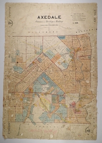
Map - AXEDALE, 26/07/1877
Map: Axedale, Counties of Bendigo and Rodney. Parish plan Draughtsman E. Daniell Sept. 1876. Examined by Harvey 1/6/1877map, bendigo, parish plan, axedale, e. daniell, harvey -
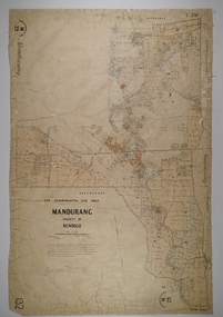
 Bendigo Historical Society Inc.
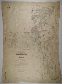
Map - MANDURANG 3, 10/11/1909
Map: Mandurang, County of Bendigo. Parish plan Examined by W. S. Stephen 11.12.79 W. E. Porter Draughtsman July 1879map, bendigo, parish plan, mandurang, w. s. stephen, w. e. porter -
 Bendigo Historical Society Inc.
Map - MANDURANG 2, Date unreadable
Map: Mandurang, County of Bendigo. Parish plan Examined by W. S. Stephen 11.12.79 W. E. Porter Draughtsman July 1879map, bendigo, parish plan, mandurang, w.s. stephen, w. e. porter -
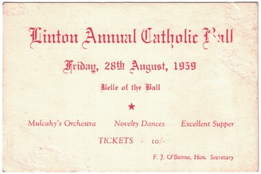 Linton and District Historical Society Inc
Ticket, Linton Annual Catholic Ball, 1959
White coloured cardboard ticket with red printed text. Ticket is for a ball held at Linton Parish Hall, Friday, 28th August, 1959.Text: " Linton Annual Catholic Ball / Friday, 28th August, 1959 / Belle of the Ball / Mulcahy's Orchestra Novelty Dances. "linton annual catholic ball, linton parish hall -
Ringwood and District Historical Society
Document, Gardens of Remembrance (Heathmont and East Ringwood) - Internments
Typed documentsRegister of Internments - Garden of Remembrance, Djerrnong Parish - Heathmont Centre Internments at Holy Trinity Memorial Garden (Djerrnong Ringwood East) -
Stawell Historical Society Inc
Book, Marie Hemley & Rev. Graeme, The opening and Dedication of the Stawell Uniting Church Community Centre, 26 June1994
Order of Service for the opening and dedication of the Stawell Uniting Church Community CentrePhotocopy White Paper cover with Photo of a church behind Title of BookletThe Unitng Church in Australia Parish of Stawell. The OPening and Dedication of the Stawell Uniting Church Community Centre. Sunday 26th June 1994stawell religion -
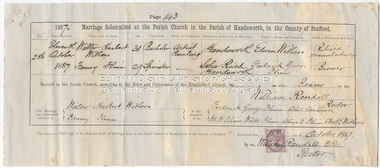 Eltham District Historical Society Inc
Certificate - Marriage Certificate, Walter Herbert Withers and Fanny Flinn, 11 October, 1887
Marriage solemnized at the Parish Church in the Parish of Handsworth, in the Couthy of Stafford Witnessed by Frederick George Flinn, Ethel Creswell, M.W. Flinn, Walter Flinn, Alice E. Flinn, Charles E. Withers1887, alice e. flinn, charles e. withers, edwin withers, ethel creswell, fanny flinn, fanny withers (nee flinn), frederick george flinn, m.w. flinn, marriage certificate, walter flinn, walter herbert withers, john withers collection -
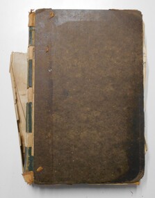 Bendigo Historical Society Inc.
Document - LANDS OFFICE: RESIDENCE AND BUSINESS AREA LEASE REGISTER, 15.12.1953 - 5.9.1974
Document: hard cover journal, brown cover with buff spine, in very poor condition. Journal contains details of leases with number and date of application, name and address of applicant, parish, allotment area, date and issue of lease. Entries mainly for parish of Sandhurst, Bendigo, some for Swan Hill, Kerang, Echuca. On spine ' Bendigo 138 01401 to - then onto cards'Lands Officebendigo, residence and business leases, lands office -
 Bendigo Historical Society Inc.
Document - MARKS COLLECTION: STRATHFIELDSAYE PLAN 1854
Plan drawn on light paper. Written on LH side of plan 'Plan of Part of the Parish of Strathfieldsaye 1854. Scale (shown) Lithographed at the Surveyor Generals Office, Melbourne July 10th. By I. Jones'. Plan shows Emu Creek and Village Reserve at top of plan, Shepherd's Creek on RH side, Parish Boundary Line on RH and bottom of plan.map, bendigo, shire of strathfieldsaye 1854 -
Clunes Museum
Map - PLAN / MAP
.1 MAP, TOWN OF CLUNES, PARISH OF CLUNES, COUNTY OF TALBOT, STAMPED BOROUGH OF CLUNES .2 PLAN OF SUBDIVISION OF PART OF CLUNES COMMON, BOROUGH OF CLUNES, PARISH OF CLUNES,COUNTY OF TALBOT. P. CAMPBELL. ASSISTANT SURVEYOR, MARCH 1904 ON RIGHT HAND BOTTOM CORNER C71/1 CLUNES COMMON. MARKED: CHARTED R.L.A.7/2/57.1 PHOTO LITHOGRAPHED. DEPARTMENT OF LANDS AND SURVEY, MELBOURNE .2 PHOTO LITHOGRAPHED AT THE DEP. OF LANDS AND SURVEY, MELBOURNE PRICE 1/- 10.11.08map town of clunes, borough of clunes, parish of clunes, county of talbot -
Bendigo Historical Society Inc.
Map - HUNTLY ? (NO NAME ON PLAN), Circa 1876
Map: Huntly?. Hand Draughted parish plan. Originally in Map Cupboard. Relocated to Map Drawer 5 on 22.9.22. Too long for the map cupboard.map, bendigo, parish plan, huntly -
Bendigo Historical Society Inc.
Map - CITY OF BENDIGO (PART), Circaa 1900
Map: parish plan showing an area North West oh Napier St., Weeroona Ave. intersection ( number 216 in Map Cupboard 1)map, bendigo, parish plan, bendigo, napier st, weeroona avenue -
Bendigo Historical Society Inc.
Map - SANDHURST (PART), Circa 1880's
Map: Parish plan showing a section of the city of Sandhurst, Northwards from Lloyd St. East bendigo. ( number 212 in Map Cupboard 1)map, bendigo, parish plan, lloyd st. sandhurst, bendigo -
Tatura Irrigation & Wartime Camps Museum
Photograph - copy, 1st Catholic Presbytery Church Tatura 1888, c1890
Copy of original photograph of 1st Roman Catholic Presbytery in Tatura built 1889. Black and white photograph of 1st Catholic Presbytery Church Tatura, showing garden and 1st Parish Priest, Father D. O'Connell, standing in front. on back - 1st Catholic Presbytery 1890 between church and Victory Hallsacred heart church tatura, 1st roman catholic church tatura 1888