Showing 1219 items matching " railway buildings"
-
 Sunbury Family History and Heritage Society Inc.
Photograph, c1920s - 1930s
The station in the photograph has not been identified.A black and white non-digital photograph with a cream border of people at a railway station and others looking over the post and rail fence at the people on the rail tracks. A row of trees are growing in the background and some buildings are also visible,railways -
 Buninyong & District Historical Society
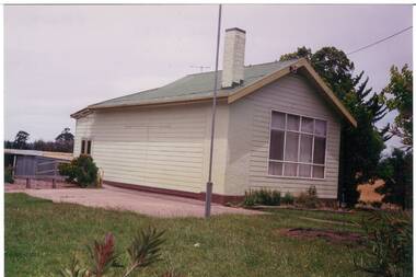
Photograph - Colour photograph, A school building in the grounds of the former Yendon Primary School
Yendon Primary School operated as a State School from 1877 and ceased operating in 1993. The School initially operated as the Buninyong East Common School from 1864.The children of railway workers from the Ballarat- Geelong railway would have formed much of the opening enrolment of the school.Colour photograph of single story building located in the grounds of the former Yendon Primary School painted cream and showing evidence of its use in 1994 as a private home including curtains and new wooden doors at the rear of the building.Yendon Primary School 1994education, yendon, state schools -
 Buninyong & District Historical Society
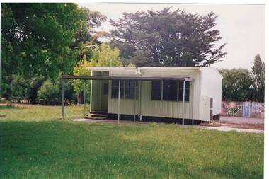
Photograph - Colour photograph, Coloured photograph of a portable school building at Yendon taken in 1994
Yendon Primary School operated as a State School from 1877 and ceased operating in 1993. The School initially operated as the Buninyong East Common School from 1864.The children of railway workers from the Ballarat- Geelong railway would have formed much of the opening enrolment of the school.Colour photograph of a portable school building in the grounds of the former Yendon Primary SchoolPre Fab - Yendon Primary School 1994education, yendon, state schools -
 Eltham District Historical Society Inc
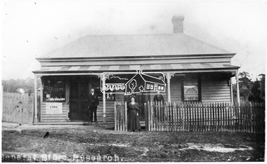
Photograph, General Store, Research, c.1900-c.1910
The original General Store at Research was also known as Doneys. It was located near where the present Main Road Research Shops are situated (opposite Ingrams Road). Charles Doney shown in front of the store. His wife Blanche is at the gate and his mother on the verandah. They had two boys Lance and Bill. The mother gave her daughter the opportunities and the graces. One of the children lived in a railway carriage behind the Church of England Research. A single chimney was unusual for a building like this. Store was demolished c. 1968 Cross Ref: SEPP_0501This photo forms part of a collection of photographs gathered by the Shire of Eltham for their centenary project book,"Pioneers and Painters: 100 years of the Shire of Eltham" by Alan Marshall (1971). The collection of over 500 images is held in partnership between Eltham District Historical Society and Yarra Plenty Regional Library (Eltham Library) and is now formally known as the 'The Shire of Eltham Pioneers Photograph Collection.' It is significant in being the first community sourced collection representing the places and people of the Shire's first one hundred years.Digital image, 18.5 x 29.5 cm print, 15.5 x 25.5 cm print and 120 format B&W negativesepp, shire of eltham pioneers photograph collection, research (vic.), general store, post office, doney family -
 Wodonga & District Historical Society Inc
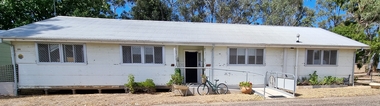
Photograph - Hut 97 Bonegilla Migrant Experience
Bonegilla Army Base and Migrant Reception Centre began when funds were allocated to build Bonegilla Army Camp in June 1940. Builders began to erect about 600 huts prior to the Army moving in during September of that year. Between 1942 - 1943 it was enlarged to 848 buildings. In 1947 Bonegilla Reception and Training Centre began operating with the Army providing transport, security and catering services. From 1949 until 1965 the Bonegilla Reception and Training Centre operated without a military presence. Bonegilla Migrant Reception and Training Centre was made up of 24 blocks. It had its own churches, banks, sporting fields, cinema, hospital, police station and railway platform. It became the largest and longest operating reception centre in the post-war era. More than 300,000 migrants passed through its doors between 1947 and 1971, with most of those originating from non-English speaking European countries. From1965 with the increased Australian commitment to the Vietnam War and the need to find accommodation to train National Servicemen for Vietnam, the Army negotiated with the Department of Immigration to take over several blocks at Bonegilla. In 1971 the Reception Centre closed and the site reverted to the Army. After 1971 the Army undertook a major site redevelopment with the construction of Latchford Barracks as the Army Apprentice School. Later Latchford Barracks was redeveloped into part of the Army Logistic Training Centre. Between 1978 and 1982, nearly all of the centre was demolished in a major redevelopment. The new replacement buildings were formally opened as Latchford Barracks in 1983. Demolition of the buildings prompted calls for recognition of the site and the role it had played in Australia’s post-World War II Immigration program. After much discussion between the Department of Army and Heritage and local groups about the significance of the site, the Australian Heritage Commission proceeded with its listing on the Register of the National Estate. A Conservation Management Plan was prepared for Block 19 in 1996. The Army transferred Block 19 to the Victorian Government. In 2002 Heritage Victoria listed Block 19 on the State Heritage Register, giving attention to both the migrant and army connections with the site. Hut 97 at Bonegilla Migrant Experience is the home of the Wodonga & District Historical Society Inc.This image is significant because it records a building which is part of the Bonegilla Migrant Reception Centre which played a critical role as the largest and longest operating Migrant Reception Centre in Australia.A colour photo of Hut 97 at Block 19, Bonegilla Migrant Experience, now the home of Wodonga & District Historical Society Inc.hut 97 bonegilla migrant experience, wodonga & district historical society, immigration australia -
 Glen Eira Historical Society
Document - Historic Conservation Areas Project
Contains 4 items relating to historic conservation: 1/Five newsletters (one page each newsletter, dated 07/1975, 08/1975, 09/1975, 10/1975 and the final one 12/1975) describing how the project evolved, project funds, progress, study method, project 1 report, project 2 report and summary as no further funds available. Project was to include all of Melbourne but funding did not allow this. Note: newsletters stamped with Caulfield Historical Society. 2/Letter (one page on official city of Caulfield letterhead) from Andrew Rodda (manager planning) to Hazal Ford (dated 13/11/1989) describing ‘council resolved on 18/07/1989 to proceed with preliminary conservation survey’ and mentions that a copy is included. 3/Preliminary conservation survey for the City of Caulfield (nine pages) describing background, study area, budget, purpose, study outline, timeframe, report format, ownership, tasks and background information (mentions number and types of houses and properties as at 1986 and 1988) and a map of City of Caulfield. 4/Booklet (28 pages) titled ‘Heritage Area – Caulfield North Draft Heritage Guidelines July 1999 – City of Glen Eira’, containing Caulfield North Heritage Area, cultural heritage, Heritage Overlay Area, architectural description, common architectural forms and features, development guidelines, key design checklist. It includes a map of the Caulfield North Heritage Overlay Area, two illustrations about the development envelope and many black-and-white photographs of houses and architectural features.historic conservation areas project niven barbara, newsletters, town planning, historic buildings, heritage studies, housing, royal historical society of victoria (rhsv), read michael, plans, local government, historical societies, committee for urban action (cua), national trust, hopkins sherry ms., ford hazel, preliminary conservation survey, town planning, heritage studies, rodda andrew, city of caulfield, housing estates, victoria national estate grants program, australia icomos, burra charter, buildings structures and establishments, land surveys, suburbs, historic buildings, architectural significance, ‘caulfield’s heritage study’, soloman geulah dr., caulfield library, dandenong road, nepean highway, hotham street, iknerman road, orrong road, north road, poath road, ‘plan of the city of caulfield’, north ward, east ward, south ward, west ward, kooyong road, neerim road, bambra road, balaclava road, shire of caulfield, railways, world war 1914-1918, depression 1929-1939, rippon lea, labassa, parks, mansions, community services, ‘caulfield north draft heritage guidelines july 1999’, city of glen eira, caulfield north heritage area, glen eira heritage management plan, mayfield grove, normanby avenue, carnarvon street, glenferrie street, arthur street, malakoff street, normanby road, heritage advisory service, construction materials, victorian style, mediterranean style, spanish mission style, californian bungalow style, federation style, architectural style, architectural features, heritage conservation design, building construction, building regulations, aboriginal peoples, carnarvon road -
Glen Eira Historical Society
Book - Caulfield Institute of Technology
... Donald K.H. Boykett Building Railway Avenue Dandenong Road Queens ...Three items of Annual Reports: 1/ Caulfield Institute of Technology Annual Report 1973. Including attached page of Council members and staff. Includes introduction giving history of the Educational establishment. 2/ Caulfield Institute of Technology Annual Report 1974. Includes photocopied sheet of staff and board names. 3/ Caulfield Institute of Technology Annual Report 1977. Includes two photocopied lists of staff and board members.ward t., boykett kenneth, whitlam gough prime minister, abbot pam, horne donald, k.h. boykett building, railway avenue, dandenong road, queens road, princes avenue, phillip law building carnegie, caulfield east, school boards, library, school of industrial studies, counselling services, computer centre, financial statement, degrees, diploma and graduate diplomas, certificates, school of engineering, school of general studies, administration services, colleges, moderne style, student union, building construction, building sites, budget task force, partridge committee (post secondary education), williams committee (education and training), saxe committee (nurse education), school of business, education, tertiary education -
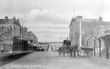 Surrey Hills Historical Society Collection
Work on paper - Photograph, Canterbury Road, near the corner of Union Road, 1911
J A Geer's grocery store operated from 1909-1912 on the site established by George Sim in 1884. He bought a house and added a shop where, in 1889, he established the first post office in the area. Prior to this residents had to go the Box Hill to collect mail. Date is approximate.This records one of the earliest businesses in Surrey Hills. To begin with, businesses developed along Canterbury Road rather than Union Road, in part because of the muddy nature of the land north of the railway line.Black and white photo taken from a postcard of Canterbury Road, near the corner of Union Road, looking west in 1906 or 1907. Two children play on the LHS of the street and there is a man on a horse and carriage, and a cart, on the RHS. Buildings on the RHS are the Surrey Family Hotel and J A Geer's grocery store; on the LHS is a row of double-storey terraces including Hansen's Terrace on Canterbury Road to the west of Union Road.On LHS within the original image is 'Canterbury Road, Surrey Hills'; on the rear in top LH corner in blue biro in Jocelyn Hall's handwriting "J H / spare"canterbury road, geer's grocery store, surrey family hotel, businesses, horse drawn vehicle, hansen's terrace, post card, mr j a geer -
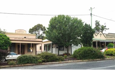 Linton and District Historical Society Inc
Photograph, Buildings in Sussex Street, Linton, 2014
... as the LDHS resource centre), and the Railway Hotel. Buildings ...Colour photograph which shows the former Linton public library building, the former Nelson Bros Undertakers building (now in use as the LDHS resource centre), and the Railway Hotel.linton public library, nelson bros undertakers, railway hotel -
 Buninyong & District Historical Society
Photograph - Colour photograph, Colour photograph of the rear of the main building of Yendon Primary School 1994
Yendon Primary School operated as a State School from 1877 and ceased operating in 1993. The School initially operated as the Buninyong East Common School from 1864.The children of railway workers from the Ballarat- Geelong railway would have formed much of the opening enrolment of the school.Colour photograph showing the rear of the former main school building of Yendon Primary and part of the playground.Yendon Primary School 1994education, yendon, state schools -
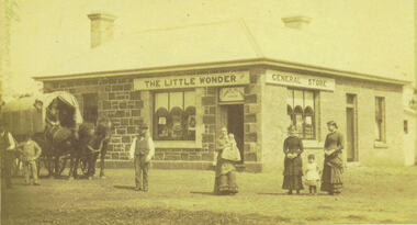 Bacchus Marsh & District Historical Society
Photograph, Alford's Little Wonder Store Bacchus Marsh 1883
The Little Wonder Store was built in 1883 from materials of the demolished Maddingley School. It was located on the corner of Grant Street and Labilliere Street. In 1886 James Alford obtained a licence to conduct the Railway Hotel and General Store there. A second storey was added later and the building continued to operate as the Railway Hotel. It was destroyed by fire in 1998. The photo also shows the covered wagon of a travelling salesman, who were known as ‘hawkers’, who were significant in the supply of goods and news to outlying towns and districts before the development of road and rail networks. Small sepia 'carte de viste' style unframed photograph on card with gold border framing photograph. Housed in the Jeremeas Family Album which contains photographs of Bacchus Marsh and District in 1883 by the photographers Stevenson and McNicoll. The photo shows a single-storey building of bluestone and brick with two signs on the front and side, the front sign reading “THE LITTLE WONDER” and the side sign “GENERAL STORE”. Above the door is a sign with the name ‘James Alford’. The windows display the merchandise of the store. Outside the store is a travelling salesman’s cart pulled by two horses. The salesman sits in the cart ready to drive off. Standing along the street outside the store are three men, three women and two young children.Printed On the front: Stevenson & McNicoll. Photo. 108 Elizabeth St. Melbourne. COPIES CAN BE OBTAINED AT ANY TIME. On the back: LIGHT & TRUTH inscribed on a banner surmounted by a representation of the rising sun. Copies of this Portrait can be had at any time by sending the Name and Post Office Money Order or Stamps for the amount of order to STEVENSON & McNICOLL LATE BENSON & STEVENSON, Photographers. 108 Elizabeth Street, MELBOURNE. stevenson and mcnicoll 1883 photographs of bacchus marsh and district, shops bacchus marsh, general stores bacchus marsh vic., hawkers, hotels bacchus marsh -
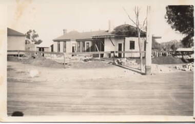 Sunbury Family History and Heritage Society Inc.
Photograph, Royal Hotel, 1936
The building being demolished in the photograph is the Railway Hotel which was destroyed by fire in 1936. It was decided to demolish the old building and rebuild a more modern hotel on the Brook/Evans Street corner where the old building had stood for 61 years.A non-digital black and white photograph with a cream border of a single storey building undergoing demolition. Two other buildings are visible on the site.royal hotel, brook street, evans street, hotels -
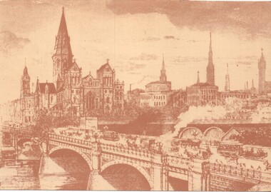
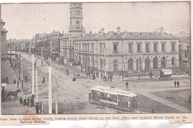 Ballarat Tramway Museum
Photograph - Illustration, WTP, "View from Lydiard Street South looking across Sturt St", c1907
Illustration of the intersection of Sturt St and Lydiard St Nth with the Ballarat Post Office being the primary feature. Has an ESCo tram turning from Sturt St into Lydiard St. Shows the trackwork at this location and has several horse-drawn vehicles in the photograph. Note the building in the road space on the left-hand side of the photograph. The caption along the bottom edge "View from Lydiard Street South looking across Sturt Street to the Post Office and Lydiard Street North to the Railway Station. On the rear has an item about Ballarat itself and its history. See also item 6245 for a postcard of this view. Yields information about the post office corner at the time of the opening of the tramway and demonstrates printing techniques.Black and white Illustration cut from a journaltramways, trams, sturt st, esco, post office, lydiard st north -
Clunes Museum
Document - HISTORY TALBOT TOWNSHIP, 1970
... OF CLUNES BUILDINGS, CHURCHES, HOSPITAL, RAILWAY STATION ETC... OF CLUNES BUILDINGS, CHURCHES, HOSPITAL, RAILWAY STATION ETC ....1 HISTORY OF TALBOT TOWNSHIP 1852 .2 PORTION OF LIST OF CLUNES BUILDINGS, CHURCHES, HOSPITAL, RAILWAY STATION ETC. COMPILED BY CONRAD WEICKHARDT 1970local history, document, talbot, history, history of talbot & clunes -
 Eltham District Historical Society Inc
Photograph - Digital Photograph, Alan King, Allwood House, Hurstbridge, 16 April 2008
Allwood - built in 1894 by Henry Hurst’s relatives, stands near the site of his house, which was demolisherd in the 1940s. Until 1924 Hurstbridge was known as Allwood. The building, one of the district's oldest is situated back from the corner of Arthurs Creek Road and Main Road. Covered under Heritage Overlay, Nillumbik Planning Scheme Published: Nillumbik Now and Then / Marguerite Marshall 2008; photographs Alan King with Marguerite Marshall.; p17 Hurst, who was a surveyor, came to Melbourne in 1852 by default, as on the way to Sydney he contracted typhoid and was off-loaded in Melbourne. Deciding to settle near Melbourne, he selected some land near the present Eltham railway station and was one of the first to grow crops there.2 But disaster struck again, when his shack was looted and burned, while he was carting goods for sale to nearby goldfields. It was then that Hurstbridge’s first settler, Cornelius Haley, asked Hurst to manage his 160 acres (65ha) grazing property and 9000 acres (3443ha) of leased land where the present Hurstbridge stands. Hurst proved equal to the tough conditions and he and his brother, Fred, cut a track with a bullock team from the property to Romsey, where Haley had selected some land. Hurst also put up a bridge across the creek near his house, after which Hurstbridge was named. He ran the property helped by two ticket-of-leave men and others, several of whom were sailors who had abandoned ship in search of gold, and were working there temporarily. In 1866, only 14 years after coming to Australia, Hurst met an early tragic death. One day a bushranger named Burke came to the house and demanded a horse. Hurst thought the bushranger might be an officer in search of runaway sailors3 and anyway, did not like the look of him, so he refused. A tussle followed and apparently Hurst shot first.4 He was shot and died five hours later from loss of blood. Later, troopers found Burke, who was subsequently hanged. The event is recorded in the Old Melbourne Gaol. The government offered the family £500 but the family refused it as ‘blood money’. Hurst’s father, Robert, even signed a petition against the bushranger’s death, claiming one life did not replace another. Hurst’s family continued to live in the district and saw a rise in their fortunes. They bought Haley’s cattle station and built the present Allwood House, using the original home as an orchard packing shed. The present Victorian style timber house had several outbuildings including a blacksmith’s shop. The property passed on to William Gray, an orchardist and nurseryman, who married Hurst’s grandniece, Frances. The business boomed from the early 1900s when it supplied most of the orchards in the area. Gray was Eltham Shire’s President for two terms and was asked to stand for parliament, but his wife’s illness and other family commitments prevented him from doing so. Then several calamities drove the family to bankruptcy. During World War One, Gray lost more than one million pounds on trees shipped overseas, which the Lloyd’s company had refused to insure. Other factors, including the Great Depression, ruined the family’s fortunes. The land was reduced from more than 640 acres (256ha) to 50 acres (20ha) and the older members married and left. After Mr Gray died, the house was leased, until his daughter Sheila Ferguson and her husband Gordon settled there in 1951, after buying it from other family members. However in 1975 the Shire designated the property as a passive recreation reserve. The Ferguson family sold most of the land, leaving the house on 0.6 hectares.This collection of almost 130 photos about places and people within the Shire of Nillumbik, an urban and rural municipality in Melbourne's north, contributes to an understanding of the history of the Shire. Published in 2008 immediately prior to the Black Saturday bushfires of February 7, 2009, it documents sites that were impacted, and in some cases destroyed by the fires. It includes photographs taken especially for the publication, creating a unique time capsule representing the Shire in the early 21st century. It remains the most recent comprehenesive publication devoted to the Shire's history connecting local residents to the past. nillumbik now and then (marshall-king) collection, hurstbridge, henry hurst, allwood house -
 Eltham District Historical Society Inc
Photograph - Digital Photograph, Alan King, Shillinglaw Cottage, 6 January 2008
Covered under National Estate, National Trust of Australia (Victoria) Local Significance and Heritage Overlay, Nillumbik Planning Scheme. Published: Nillumbik Now and Then / Marguerite Marshall 2008; photographs Alan King with Marguerite Marshall.; p95 Thanks to an Australia first effort by local residents, the historic Shillinglaw Cottage still survives. The cottage at Panther Place, Eltham, once stood about 100 metres away on Main Road. But in 1963 it faced demolition to make room for the Eltham Shire Offices (since demolished). However residents rallied to save Shillinglaw Cottage and became the first in Australia to remove and reconstruct an early settler’s brick building. A fundraiser was the residents’ compilation of loved recipes into the cookery book, Flavour of Eltham. The cottage, built in the late 1870s by noted pioneer builder George Stebbing, is one of Eltham’s earliest buildings and associated with significant early settlers. It is on the National Estate and National Trust Registers. The cottage was constructed with handmade bricks in the Flemish Bond style, typical of cottages and farmhouses in Flanders, Europe. It features burnt ‘header’ bricks over the façade, which gives a chequered effect. The roof is made of slate, while the windows are 12-paned sash with relieving arches. It is not clear who were the first owners of the cottage. The National Trust claims that Stebbing built it for farmer Thomas Cochrane.1 Others say Cochrane first owned the land but Stebbing was Shillinglaw’s first owner and remained so until 1887. The Shillinglaw family then bought it and lived there for around 80 years until 1963 when they sold it to the Eltham Council.2 Farmer Thomas Cochrane bought the Shillinglaw Cottage site from land developer Josiah Holloway. The site was the largest in what Holloway called Little Eltham, of some 30 acres (12 ha), extending along the creek from Henry Street to Luck Street. In 1874 Cochrane sold the land to George Stebbing. Meanwhile in 1861, Stebbing was the owner and occupier of a house at Pitt Street, Eltham, which he had built. Evelyn Observer journalist James Rossiter rented the Pitt Street house, then in 1881 Phillip Shillinglaw occupied it. Stebbing constructed several buildings of note in the area, including the Uniting Church at John Street, the building beside it – a former bank – and St Margaret’s Church of England in Pitt Street. Stebbing was also an Eltham Shire Councillor from 1871 to 1873 and a trustee and treasurer of the Eltham Wesleyan Church.3 In the 1870s he is recorded as the owner of up to five houses. Earlier he had been described as a bricklayer and later became a farmer. In 1882 Stebbing returned to the Pitt Street house and Shillinglaw occupied the new house in Main Road, which he owned from 1887. Shillinglaw was a prolific poet and preached at the Eltham Primitive Methodist Church, where he also served as Sunday School superintendent and led the Young People’s Society Christian Endeavour. The Shillinglaws saw many changes in their property’s boundaries – the major one occurring at the turn of the century when land for the railway and Eltham station was acquired from their holding. The northern part of the remaining land was then used for some of the first commercial developments in what was to become the Eltham Shopping Centre. Later still, the land immediately north of the cottage was bought by the Eltham War Memorial Trust for the War Memorial Buildings and the fire station. The Trust’s land eventually passed to the council. The council bought the remaining two acres (0.8 ha) with the house, and with the exception of the commercial development between the fire station and the post office, all of the former Shillinglaw land is owned by the council or government instrumentalities.4 Since the late 20th century, the cottage has had varied uses, such as a handcrafts store and as a restaurant.This collection of almost 130 photos about places and people within the Shire of Nillumbik, an urban and rural municipality in Melbourne's north, contributes to an understanding of the history of the Shire. Published in 2008 immediately prior to the Black Saturday bushfires of February 7, 2009, it documents sites that were impacted, and in some cases destroyed by the fires. It includes photographs taken especially for the publication, creating a unique time capsule representing the Shire in the early 21st century. It remains the most recent comprehenesive publication devoted to the Shire's history connecting local residents to the past. nillumbik now and then (marshall-king) collection, shillinglaw cottage -
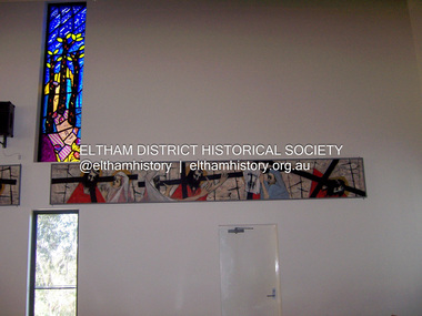 Eltham District Historical Society Inc
Photograph - Digital Photograph, Marguerite Marshall, Stations of the Cross, Clifton Pugh (1961); Our Lady Help of Christian's Church, Henry Street, Eltham, 11 October 2006
Stations of the Cross by Clifton Pugh is a contempooray art piece in four sections making up 11 stations of the cross. It was commissioned by the Catholic parish in Eltham (Our Lady Help of Christians) in 1961 Published: Nillumbik Now and Then / Marguerite Marshall 2008; photographs Alan King with Marguerite Marshall.; p81 Art is an important means of nurturing faith at Our Lady Help of Christians Church, Henry Street, Eltham. The Stations of the Cross by Clifton Pugh and The Crucifix with the Ascending Jesus by sculptor Charles Rocco are two of the fine works that enhance the parishioners’ worship. These two inspiring works of art were added in 2001 – long after Roman Catholics began worshipping in Eltham around 1864. This beautiful worship centre was built following hardship and change – for parishioners have endured their church being destroyed by fire and have built four churches since they first worshipped together. Before 1864, according to local legend, a visiting priest administered sacraments in the parlour of former convict-turned-respected citizen Thomas Sweeney at Sweeneys Lane, Eltham.1 The first church was blessed in September, 1865, by the Archbishop of Melbourne, Dr Goold. It stood on an acre (0.4ha) of land in Little Eltham as that area was known then, near the present Fordhams and Main Roads and was part of the Heidelberg Church Parish. In 1912 the church was relocated to a new building on the present primary school site at 1 Henry Street. This was closer to the town centre, which had moved from Little Eltham after the railway line was extended to Eltham in 1902.2 In 1958 the church split from the Sacred Heart parish, Diamond Creek, to become a parish in its own right, with Father Tom Curran as inaugural priest. Not long after in 1961, a fire destroyed the church and huge working bees under the prominent Catholic builders, the Sibbel brothers, rebuilt and extended it, using the original altar from the first church. It was then that builder and parishioner Herman Sibbel asked his friend, artist Clifton Pugh, to paint the Stations of the Cross for the church. But the priest, Father Curran, neither approved of Pugh’s bohemian reputation nor liked the paintings, so they were hung in the corridor of Our Lady’s Primary School instead. The parishioners almost sold the paintings in 1989 to pay for major school renovations. However the paintings remained there for about 40 years, until 2001, when the church was extensively renovated by Father Barry Caldwell. Another change awaited the church, as it outgrew its building, later to be used as the school hall. So, in 1976, the present church was built across the road. Three beautiful stained-glass windows depicting the Passion, Death, Resurrection and the presence of Christ’s Spirit, link these with the church’s experiences. The first depicts a bushfire in Eltham, referring to their church damaged by fire. Another represents the Resurrection of Christ with new growth on a blackened stump and the Holy Spirit is represented by the Southern Cross. A window depicting Our Lady Help of Christians by parishioner Bill Peperkamp, was donated by parishioners to commemorate the Silver Jubilee of Father Desmond G Jenkins’ ordination to the priesthood on July 27, 1977. This, with the statue of Mary, creates a Marian shrine. In the 14 Stations of the Cross painted on four masonite panels Pugh captures the pathos of the suffering Christ and his disciples.3 The figures are stylised, except intriguingly, that of Pontias Pilate, who looks like Clifton Pugh. Charles Rocco’s sculpture is an extraordinary Jesus figure being raised from the Cross. The delicate stainless steel mesh of the figure creates a sense of the power of God over death. The organ, built in 1868 by George Fincham and Sons, was first installed in the All Saints’ Anglican Church, East St Kilda, then in the St Andrews Church, Clifton Hill. It was rebuilt into a modern instrument with a donation from parishioner Jim Murray, in memory of his wife Gwendolene Mary.4 Church members created their own work of art in front of the entrance, by painting designs and messages on 700 tiles. This work indicates the strong church family and faith expressed in art, that awaits the worshipper inside.This collection of almost 130 photos about places and people within the Shire of Nillumbik, an urban and rural municipality in Melbourne's north, contributes to an understanding of the history of the Shire. Published in 2008 immediately prior to the Black Saturday bushfires of February 7, 2009, it documents sites that were impacted, and in some cases destroyed by the fires. It includes photographs taken especially for the publication, creating a unique time capsule representing the Shire in the early 21st century. It remains the most recent comprehenesive publication devoted to the Shire's history connecting local residents to the past. nillumbik now and then (marshall-king) collection, art, clifton pugh, stations of the cross, our lady help of christans, installation -
 Eltham District Historical Society Inc
Photograph - Digital Photograph, Alan King, Memorial Arch Gateway, Nillumbik Cemetery, Diamond Creek, 23 January 2008
The Nillumbik Cemetery is of historical, architectural, aesthetic and social significance at a Regional level (North-east Melbourne). The memorial arch is of State significance. Nillumbik Cemetery, which was established in 1867, is of historical and social significance for its association with the early history of Diamond Creek and as a record of the pioneering families of the district. Significant graves include those of the famous writer Alan Marshall, author of 'I Can Jump Puddles', footballer Gordon Coventry, and William Ellis, notable early settler and benefactor. The 1897 Tudor/Gothic revival memorial arch, bequeathed by William Ellis, is a rare design in ornamental gateways and is relatively large for the size of the cemetery. It is unique in Victoria as a cemetery gateway arch. The burial ground has associated structures, such as the hexagonal timber sexton's office, post and wire fence and picket hand gate along Main Street, all probably built in the early twentieth century. Covered under Heritage Overlay, Nillumbik Planning Scheme. National Trust of Australia (Victoria) - Regional significance Published: Nillumbik Now and Then / Marguerite Marshall 2008; photographs Alan King with Marguerite Marshall.; p83 Entering Nillumbik Cemetery through an ornamental gateway and shaded by the Monterey Cypress hedge helps one leave the busy world outside and contemplate yesterday’s Diamond Creek. The gateway, classified by the National Trust of Australia (Victoria), and inscribed with ‘JANVA VITAE’ (gate of life), was a gift from a distinguished pioneer, William Ellis. Ellis, who was an original trustee of the Nillumbik Cemetery representing the Primitive Methodists and a successful farmer, bequeathed £100 to build the red-brick and carved stone gateway in 1887. In 1867 surveyor Edward Bage had set aside two acres (0.8ha) now 35 Main Street, for this cemetery, in what was then called the village of Nillumbik. Several earlier burials on private lands in the district might have been exhumed and re-interred in the new cemetery. The first burials in the cemetery are thought to be of ‘a Chinaman who hanged himself from a tree behind the Church of England’ and ‘another man who was drowned in a water-hole behind the same church’.1 The 1000 or so graves in the cemetery are grouped into five denominational sections: two Anglican and one each for the Methodist (the largest), Catholic and Presbyterian Churches. It is believed that several unmarked graves are of Aborigines and Chinese miners.2 Perhaps the most famous person buried in the cemetery was author Alan Marshall, who died in 1984 and wrote, among other books, I Can Jump Puddles. Surprisingly his grave is particularly modest consisting of only a grassed plot with a tiny boulder and a simple bronze plaque. It lies about halfway down the main path, at the west and third row back. The first European, interred at the cemetery on July 9, 1869, was Hannah, aged 13 years eight months, daughter of local orchardist John Lawrey and wife Honor.3 Each grave has a story which reflects a rich history. Phillip Cummings, who died in 1884, provided the barn for Diamond Creek’s first school, run by the Primitive Methodist Church. The barn stood at the corner of Phipps Crescent and the main road.4 Former Eltham Shire councillor George Stebbings, who died in 1896, built several prominent buildings in the district, including Shillinglaw Cottage in Eltham.5 The grave of miner James Joseph Whyte, who died in 1908, is a reminder of Diamond Creek’s gold mining history. At age 51, Whyte died from a rock fall in the Diamond Mine, Diamond Creek. Diamond Creek’s first butcher, Patrick Ryan, became President of the Shire of Heidelberg and Chairman of the Eltham Hurstbridge Railway Trust. A former gold miner, he was grandfather of local historian Reverend Jock Ryan. He was buried in an unmarked grave halfway down the central path. His son John Lawrence, who is buried elsewhere, had been a Mayor of the City of Heidelberg. George Martin Pizzey gave a hall, for what was to become The St John’s Anglican Church in Diamond Creek. He was a Crimean War veteran, mason and leather goods manufacturer in Melbourne, who died in 1915. The two world wars took a heavy toll of locals with 54 personnel buried here, two thirds of whom served in World War One. A sporting pioneer was Greensborough District Cricket Club founder, Andrew Webb, who was buried in 1971. Politician Roy Mountford Vale (Monte), who died in 1977, was a Member of the Legislative Assembly of Greensborough, and a founding councillor and president of the Diamond Valley Shire. Modern-day residents are also remembered in this cemetery. The tragic Ash Wednesday bushfires took their toll on the district: William Marsden of Panton Hill CFA died, aged 39, fighting bushfires at Upper Beaconsfield in 1983.6 Several graves tell of those who held distinguished positions overseas, including William Constable, who died in 1989. Constable was artistic director of a ballet company, art director of more than 30 films for London-based film productions, and was awarded best Film Art Director at the Moscow Film Festival in 1960.This collection of almost 130 photos about places and people within the Shire of Nillumbik, an urban and rural municipality in Melbourne's north, contributes to an understanding of the history of the Shire. Published in 2008 immediately prior to the Black Saturday bushfires of February 7, 2009, it documents sites that were impacted, and in some cases destroyed by the fires. It includes photographs taken especially for the publication, creating a unique time capsule representing the Shire in the early 21st century. It remains the most recent comprehenesive publication devoted to the Shire's history connecting local residents to the past. nillumbik now and then (marshall-king) collection, diamond creek, memorial arch, gateway, nillumbik cemetery, william ellis -
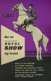 Melbourne Royal
Poster, Go to Melbourne's Royal Show by train, 1958
This poster promotes the merits of travelling by train to the Royal Melbourne Show of 1958. The Showgrounds train station was one of the first buildings built on the Melbourne Showgrounds in Ascot Vale when the site was established in 1883, allowing patrons quick access to the venue despite it being slightly further out from the city than previous sites.A poster, printed portrait and in colour. The upper half of the poster shows a woman on a jumping horse, on a purple background; the lower half consists of a list of the advantages of taking the train, lettered in white on a black background; screenprint and process lithograph, linen-backed.SEPT. 19 – 28 / Go to / MELBOURNE'S / ROYAL SHOW / by train / - RIGHT TO THE GROUNDS / - NO PARKING PROBLEMS / - COMBINED RAIL-ADMISSION TICKETS / - WEEKLY OR NINE DAY RAIL TICKETS / - SEE THE RAILWAYS EXHIBIT / - MEMBERSHIP TICKETS AT VICTORIAN / GOVT. TOURIST BUREAU /train, metro trains, showgrounds, melbourne showgrounds, royal melbourne show, 1958 melbourne royal show, melbourne royal show, showgrounds station, railway -
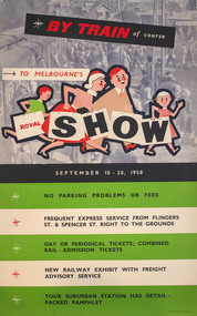 Melbourne Royal
Poster, W. M. Houston, By train of course, to Melbourne's Royal Show, 1958
A poster promoting the merits of travelling by train to the Royal Melbourne Show of 1958. The Showgrounds train station was one of the first buildings built on the Melbourne Showgrounds in Ascot Vale when the site was established in 1883, allowing patrons quick access to the venue despite it being slightly further out from the city than previous sites.A portrait poster, printed in colour; in the upper half of the poster there is an illustration showing a family of four, walking to the right; in the background is a photograph of a train station; the lower half of the poster consists of a list of the advantages of taking the train, printed on five horizontal stripes, white and green; colour process lithograph, linen-backed.BY TRAIN of course / TO MELBOURNE'S / ROYAL SHOW / SEPTEMBER 18 - 28, 1958/ NO PARKIGN PROBLEMS OR FEES / FREQUENT EXPRES SERVICE FROM FLINDERS ST. & SPENCER ST. RIGHT TO THE GROUNDS / DAY OR PERIODICAL TICKETS; COMBINED RAIL-ADMISSION TICKETS / NEW RAILWAY EXHBIIT WITH FREIGHT ADVISORY SERVICE / YOUR SUBURBAN STATION AHS DETAIL-PACKED PAHMPHLET /train, metro trains, showgrounds, melbourne showgrounds, royal melbourne show, 1985 melbourne royal show, melbourne royal show, showgrounds station, railway -
 Melbourne Tram Museum
Photograph - Black and white - Glenferrie Road, Glenferrie c1915
Shows Glenferrie Road, near Linda St looking south, c1915 prior to the construction of the Railway overpass at Glenferrie Railway Station with H class tram 58 in the view. The tram line was constructed in 1913. It would appear that the level crossing gates are closed in the photograph. The building on the right-hand side by the horse-drawn cart was an ANZ bank until 2021. The closer building, a theatre (The Palace) has since been demolished and is now a Coles Supermarket. The level crossing was replaced with an overbridge in April 1916. The church in the background is the Immaculate Conception Church, without the spires - built after WW1. Yields information about the location, the streetscape and the tram, vehicles in use at the time. Black and white photograph of Glenferrie Road Glenferrie with tram H58, looking south near Linda St, c1915."RSCP 327" & "C1920s" in pencil on rear and H58 in red ink.tramways, trams, glenferrie road, hawthorn, streetscapes, h class, tram 58 -
 Melbourne Tram Museum
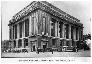
Photograph - Black and White - Mail Exchange Spencer and Bourke Streets c1920
Photo of the Mail Exchange Building with a cable tram loading prior to departure and a number of motor vehicles. The photo shows the monumental construction for the then Post Master Generals Department. This building was completed in 1917 to replace the mail sorting functions of the GPO on the corner of Bourke and Elizabeth St. It had tunnels that connected with Spencer Street Railway station opposite and was designed for the sorting and transporting of mail.Yields information about the Mail Exchange building.Photograph - Black and White - Mail Exchange Spencer and Bourke Streets c1920tramways, trams, cable cars, bourke street, spencer street, post office, post master general, mail exchange -
 Emerald Museum & Nobelius Heritage Park
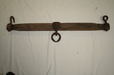
Whippletree, Pre WW2
... , which was used for building the 'Puffing Billy' railway and also ...The whippletree consists of a loose horizontal bar between the draught animal and its load. The centre of the bar is connected to the load, and the traces, chains or straps on each side of the harness, attached to its ends. Whippletrees are used when pulling a dragged load such as a plough, harrow, or log. The whipple tree was attached to a scoop, which was used for building the 'Puffing Billy' railway and also for scooping out Emerald Lake.Wooden bar with metal hook at each end and a metal ring attached to the centre. -
 Melbourne Tram Museum
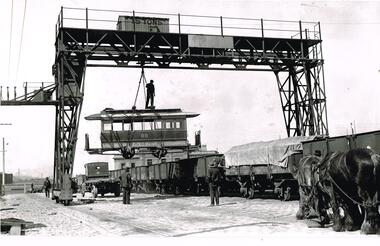
Photograph - Black and White - Loading cable car trailer 88 at Spencer St
Black and white photograph of cable trailer 88 being loaded onto a wagon at the Spencer St / Flinders St railway yard by the railway yard travelling gantry crane. Trailer lettered M&MTB. Has a man riding the top of the car before being loaded into a I type open wagon. Photo mid to late 1920s? Photo from the Collection of the Department of Infrastructure now with the Public Records Office - image number "Box 108-1. Note: this photo is now out of copyright and may not have been an original VR photograph, but one copied from another source and collected as their Heritage series. The building in the background in Flinders Street (extension/west.) is the former Melbourne Harbour Trust Officers. By the time of this photo was taken the building was in the hands of the Department of Agriculture. Their name can just be seen on the top part of the building. It was demolished when the convention centre was built beside the WTC in the mid-1980’s. The crane was dismantled in the late 1990s around the time of the No 1 goods shed was moved to Bylands. The cable car has been stripped of a number of parts : Some windows. All the brake rigging and pawls All the roof-mounted destination boxes. The wheel skirt.Shows how redundant cable trams were sold and transported to country locations.Photograph - Black and White - Loading cable car trailer 88 at Spencer StHas Department of Infrastructure copy right stamp on rear and number "Box108-1" in ink on rear and "1-8"tramways, trams, cable trams, flinders st, sale of trams, railways, tram 88 -
 Melbourne Tram Museum
Artwork, other, Princes Bridge from the south bank of the Yarra River, c1900
Sepia toned print of a drawing of Princes Bridge with St Paul's Cathedral and other buildings. Has a number of cable trams and horse drawn vehicles on the bridge. The artist has taken liberties and drawn the spires onto St Paul's cathedral and other buildings such as Princes Bridge railway station. The spires is most likely based on the proposed design at the time. They were built in 1926 to a changed design - see reference.Yields information about the Princes Bridge precinct.Reproduction of a Lithograph drawing - Princes Bridge from the south bank of the Yarra River.melbourne, princes bridge, horse drawn vehicles, st pauls cathedral, cable trams -
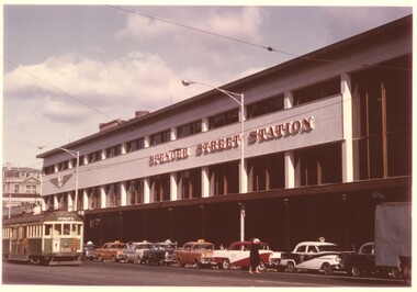 Melbourne Tram Museum
Photograph - Spencer St Station and W2 536, c1962
Photo shows the new Spencer St station which was completed around 1962 with tram W2 430 (Spencer St, Route 48), fitted with large trolley bridges, northbound to the terminus at Latrobe St. Eight taxis are lined up at the taxi stand, mostly Holdens with at least one Ford.Yields information about the Spencer Station building when new and the taxis serving the station.Colour print - satin finish print - Spencer St Station and W2 536 c1962railways, victorian railways, spencer st, spencer st station, taxis, w2 class, tram 536 -
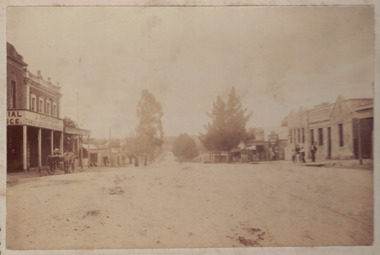 Linton and District Historical Society Inc
Photograph, Sussex Street, Linton, circa 1900
Sepia photograph mounted on grey card shows buildings in Linton's main street. On LHS of photo "J. Shepherd Grocer & Ironmonger", with horse-drawn cart outside. Railway Hotel, James Nelson Undertaker, and library buildings on RHS of photo, people standing outside hotel and children in front of undertaker's. Dating the photo: James Nelson, whose premises are shown next to the hotel, took over his family's carpentery and undertaking business in 1901. The original hotel was a timber structure or structures. It is believed these were removed in about 1903 and a new brick hotel built around 1903-1904.sussex street, linton, streetscapes, horse drawn vehicles, hotels, commercial buildings -
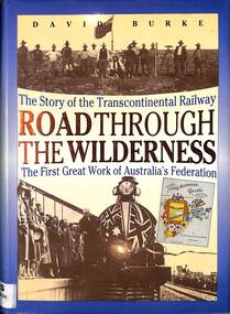 Victorian Railway History Library
Book, Burke, David, Road Through The Wilderness: The Story of the Transcontinental Railway, 1991
... - History A history of the building of the Transcontinental railway ...A history of the building of the Transcontinental railway from Port Augusta to Kalgoorlie, the first great work of Australia's federation.index, ill, maps, p.280.A history of the building of the Transcontinental railway from Port Augusta to Kalgoorlie, the first great work of Australia's federation.railway construction - australia, trans-australian railway - history -
 Victorian Railway History Library
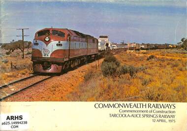
Booklet, Commonwealth Railways, Commonwealth Railways Commencement of Construction Tarcoola-Alice Springs Railway, 1975
A commemorative booklet to mark the start of the building of the standard gauge railway from Tarcoola to Alice Springs on 12th April 1975.ill, maps, p.16.A commemorative booklet to mark the start of the building of the standard gauge railway from Tarcoola to Alice Springs on 12th April 1975.railway construction - australia, trans-australian railway - history -
 Victorian Railway History Library
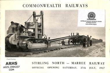
Booklet, Commonwealth Railways, Commonwealth Railways Stirling North - Maree Railway, 1957
A commemorative booklet to mark the start of the building of the standard gauge railway from Stirling North to Maree on 27th July 1957.ill, maps, p.16.A commemorative booklet to mark the start of the building of the standard gauge railway from Stirling North to Maree on 27th July 1957.railway construction - australia, north australia railway - australia - history