Showing 6761 items matching " rivers"
-
 Melbourne Tram Museum
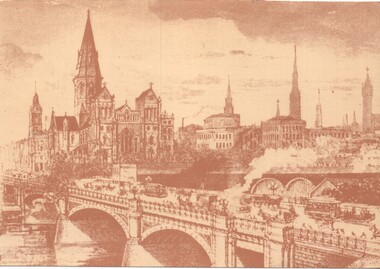
Artwork, other, Princes Bridge from the south bank of the Yarra River, c1900
Sepia toned print of a drawing of Princes Bridge with St Paul's Cathedral and other buildings. Has a number of cable trams and horse drawn vehicles on the bridge. The artist has taken liberties and drawn the spires onto St Paul's cathedral and other buildings such as Princes Bridge railway station. The spires is most likely based on the proposed design at the time. They were built in 1926 to a changed design - see reference.Yields information about the Princes Bridge precinct.Reproduction of a Lithograph drawing - Princes Bridge from the south bank of the Yarra River.melbourne, princes bridge, horse drawn vehicles, st pauls cathedral, cable trams -
 Lakes Entrance Historical Society
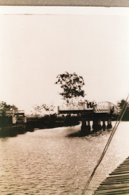
Photograph, 1925
Sepia photograph showing swing bridge open, on Latrobe River, at Longford, Victoriabridges, waterways -
 Lakes Entrance Historical Society
Book, Jones, Colin, Lakes Passenger Vessels, 2012
A study of passenger vessels on the Gippsland Lakes and rivers, from about 1880 to 2010ships and shipping -
 Lakes Entrance Historical Society
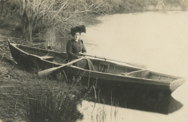
Postcard, Tambo River, 1900 c
Black and white postcard showing a woman in a row boat on Tambo River VictoriaB Ross on back of cardwaterways, transport -
 Lakes Entrance Historical Society
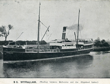
Postcard - SS Wyrallah, 1905
One other sepia copy same. One other copy in spare boxBlack and white postcard showing SS Wyralla in Mitchell River Bairnsdale Victoria.Advertisement on back. S.S. Wyralla Trading between Melbourne and the Gippsland Lakes on frontwaterways, ships and shipping, trade -
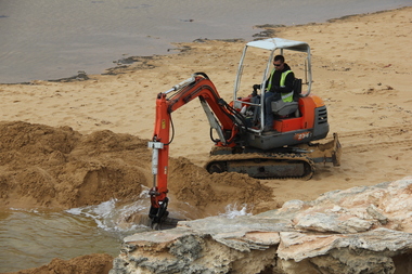 Ballarat Heritage Services
Photograph - Digital photographs, L.J. Gervasoni, Hopkins River Mouth blocked - channel digger, c2010 - 2017
Colour photograph of the blocked mouth of the Hopkins River being opened by a channel digger. hopkins river, mouth, point ritchie, bluehole, warrnambool, coast, coastal, beach, seascape, blocked, digger, opening mouth, mechanical opening -
Lakes Entrance Historical Society
Book, Moon, Mick and Vere, The Days of Mick Moon Along the Snowy River by Mick and Vere Moon, 1988
Stories of day-to-day life of a family and their neighbours living along the Snowy River.settlers, animals -
Lakes Entrance Historical Society
Book, Ronald Parsons, A Pioneer Australian Steamship Company, 1990
A history of the Hunters River S N Co, and the Australian Steam Navigation Company.ships and shipping, maritime history -
Lakes Entrance Historical Society
Photograph - PS Tanjil, 1880 c
PS Tanjil was burnt to the waterline in February 1885Black and white photograph of the first PS Tanjil in the Mitchell Rivers Bairnsdale Victoriaboats and boating, waterways -
Clunes Museum
Postcard, HOLMFIRTH
ON THE CARD, A PRETTY SCENE NEXT TO A RIVER WITH WATER LILLIES AND A LADY PICKING FLOWERSlocal history, postcards -
 Lakes Entrance Historical Society
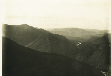
Photograph - Snowy River at Glenantipy, Rev John Flynn, 1906 c
Photographic proof on light cardBlack and white photograph of view of Snowy River from the lookout at Gelantipy Victoriatopography, waterways -
 Lakes Entrance Historical Society
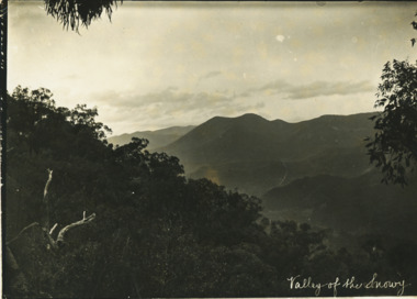
Photograph - Valley of the Snowy, Rev John Flynn, 1906
Photographic proof on light cardBlack and white photograph of Snowy River from top of Turnback Mountain VictoriaValley of the Snowywaterways -
 Lakes Entrance Historical Society
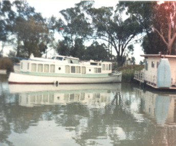
Photograph, Frank Mitchelson, Earlie, Murray River Renmark South Australia, 1990 c
Earlie was built for R G Brownlow of Eagle Point built at Sydney 1900 c sailed from Sydney to Gippsland Lakes by R G Gilbert Brownlow. To Renmark 1985A colour photograph of the motor launch Earlie on the Murray River Renmark South Australiaboats and boating, tourism -
 Federation University Historical Collection
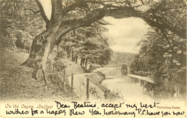
Postcard - black and white, On the Lagan, Belfast, c1900, c1900
WW1 Holmes Family souvenirAustralian WW1 soldier's souvenirTwo black and white postcards of a treed scene with river. It is the Lagan, Belfast, Irelandchatham-holmes family collection -
 Kew Historical Society Inc
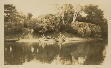
Photograph - Victorian Canoe Club, V.C.C. Studley Park, 1920-30
Canoeing on the River Yarra at Melbourne was an important and widespread recreational pursuit for Melbournians, especially in the first half of the twentieth century. The Victorian Canoe Club was formed in 1912 at a meeting in Melbourne and its first committee elected in the same year. Records indicate that the Club continued into at least the 1950s .The album has historic and social significance as a record of recreational activities (as well as canoe making) in the early years of the twentieth century. It has local significance as the site of the headquarters of the Club was in Studley park. A number of photographs in the album provide vistas of Kew on the Yarra that are otherwise unavailable.One of 24 labelled photos in part album, originating from the Victorian Canoe Club, which had its headquarters in Studley Park, Kew. The album includes a photographic record of canoe construction and also locations in Studley Park and Kew where the canoes were used. The subject of this photograph is identified as 'V.C.C. Studley Park' with its single storey weatherboard club house on the banks of the Yarra River."V.C.C. Studley Park"victorian canoe club, river yarra, studley park, boat houses, canoe clubs -
 Kew Historical Society Inc
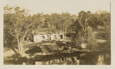
Photograph - Victorian Canoe Club, Camp site near Burke Road, 1920-30
Canoeing on the River Yarra at Melbourne was an important and widespread recreational pursuit for Melbournians, especially in the first half of the twentieth century. The Victorian Canoe Club was formed in 1912 at a meeting in Melbourne and its first committee elected in the same year. Records indicate that the Club continued into at least the 1950s .The album has historic and social significance as a record of recreational activities (as well as canoe making) in the early years of the twentieth century. It has local significance as the site of the headquarters of the Club was in Studley Park. A number of photographs in the album provide vistas of Kew on the Yarra that are otherwise unavailable.One of 24 labelled photos in part album, originating from the Victorian Canoe Club, which had its headquarters in Studley Park, Kew. The album includes a photographic record of canoe construction and also locations in Studley Park and Kew where the canoes were used. The subject of this photograph is identified as 'Camp site near Burke Road' with four canoes on the river bank with members beside them. "Camp site near Bourke Rd"victorian canoe club, river yarra, canoe clubs, canoeing, recreation -- canoeing, burke road -- kew (vic.), kew -
 Kew Historical Society Inc
Photograph - Flooding of the Yarra Valley at Kew East, 1974
Flooding of the Yarra Valley, including that section of the Yarra bordering Kew and Kew East in the north and west of the municipality, was a regular occurrence. Extreme flood events of the Yarra River are recorded to have occurred in 1891, 1901, 1916, 1923 and 1934. The Municipality of Kew's response to these floods was to enact planning decisions restricting residential development in flood prone areas following the floods of 1916, 1921 and 1934. While floods continued after the development of the Upper Yarra Reservoir (construction 1948-57), the regularity and extent of these inundations diminished. During the nineteenth century, the land abutting the south side of the Yarra in Kew was devoted to dairy farming. In the twentieth century, before and after the construction of the Eastern Freeway, much of this low-lying area was used as golf courses and public parks.Late example of the capacity of the Yarra Valley at Kew to flood, even though drainage works and the Upper Yarra Reservoir had reduced their regularity.Original black and white print photograph of the low-lying land at East Kew under floodwater on 16 May 1974. The vantage point of the photographer is Lister Street. Flooding was caused by overflowing water in Glass' Creek and the River Yarra. Annotation verso: "Lister Street looking north / Flood level / 16 May 1974 11.30am / R.L. 46.04"hays paddock, floods, yarra river, glass' creek, lister street -
 Kew Historical Society Inc
Photograph - Flooding of the Yarra Valley at Kew East, 1974
Flooding of the Yarra Valley, including that section of the Yarra bordering Kew and Kew East in the north and west of the municipality, was a regular occurrence. Extreme flood events of the Yarra River are recorded to have occurred in 1891, 1901, 1916, 1923 and 1934. The Municipality of Kew's response to these floods was to enact planning decisions restricting residential development in flood prone areas following the floods of 1916, 1921 and 1934. While floods continued after the development of the Upper Yarra Reservoir (construction 1948-57), the regularity and extent of these inundations diminished. During the nineteenth century, the land abutting the south side of the Yarra in Kew was devoted to dairy farming. In the twentieth century, before and after the construction of the Eastern Freeway, much of this low-lying area was used as golf courses and public parks.Late example of the capacity of the Yarra Valley at Kew to flood, even though drainage works and the Upper Yarra Reservoir had reduced their regularity.Original black and white print photograph of the low-lying land at East Kew under floodwater on 16 May 1974. The vantage point of the photographer is Lister Street. Flooding was caused by overflowing water in Glass' Creek and the River Yarra. Annotation verso: "Lister St looking same as No.3 / 16 May 1974 11.30"floods, yarra river, glass' creek, lister street -
 Kew Historical Society Inc
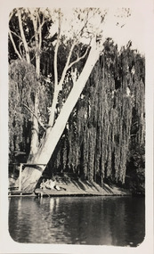
Photograph - Macauley's, Kew, 1924
Henry Beater Christian (1886-1962) , was a descendant of one of the earliest settler families in Kew. Employed at the Kew Asylum as a 'public servant', he was a skilled amateur photographer, photographing numerous scenes in Kew and on his travels around Victoria. The majority of his photographs date from 1916 to 1929. His finest photographs are housed in two photograph albums. A fine, early view of the river bank at Macauley's boat sheds on the Yarra River at Kew.Digital copy of a photograph from page 2 of the 47-page photograph album containing 261 gelatinous silver images, loaned by Diane Washfold with permission given to digitise and hold a copy in our collection. The photograph is of the river bank at Macauley's boat sheds on the Yarra River at Kew. The boat sheds were located at the west end of Molesworth Street. The photograph is taken from the Yarra Bend Park side of the river, or from a boat on the river. A group, probably members of the photographer's family, are sitting underneath a giant weeping willow."Macauley’s Kew"henry beater christian (1886-1962), landscape photography, kew (vic.) — yarra river, christian-washfold collection, photograph albums, macauley's boat sheds -
Port Melbourne Historical & Preservation Society
Photograph - Aerial view of Yarra River and surrounds, 1990s
COPYRIGHT THE AGE Aerial photograph showing the Yarra River, Webb Dock, Port Melbourne beach, Princes pier, West Gate Bridge, Maribyrnong River, Swanston Dock and Melbourne City skyline. Taken mid 1990sStamped "Copyright. This photograph may not be reproduced without permission in writing from the Photo sales department of "the Age"'built environment - commercial, engineering - bridges, fishermans bend, natural environment - beaches and foreshore, piers and wharves - princes pier, piers and wharves - webb dock, transport - shipping, yarra river, west gate bridge, sandridge beach, maribyrnong river, swanston dock -
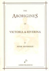 Victorian Aboriginal Corporation for Languages
Book, Peter Beveridge et al, The Aborigines of Victoria and Riverina, 2008
The Beveridges pioneered the Swan Hill area on the Murray River and lived among the People of the Murray River. They learned the Aboriginal dialects, lore and customs. Peter Beveridge faithfully recorded these and his book was published posthumously by his family.maps, b&w illustrations, b&w photographsvictorian history, murray river -
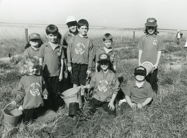 Lakes Entrance Historical Society
Photograph - Swan Reach School, Lakes Post Newspaper, 1996
Photo appeared in Lakes Post Newspaper 8 May 1996, page 1.Black and white photograph of ten Swan Reach Primary School students planting trees on the banks of the Tambo River, in conjunction with Johnsonville Angling Club, SGAP and Tambo / Nicholson River management Board. Swan Reach Victoriaschools, students, community organisation -
 University of Melbourne, Burnley Campus Archives
Photograph - Colour print, Konica, Lagoon or Boulevard Paddock, Unknown
2 colour photographs. 1. Lagoon or Boulevard Paddock and Quad Classrooms from the other side of the Yarra River. 2.View towards the rock bank behind Swan Street from the other side of the Yarra River.lagoon paddock, boulevard paddock, quad classrooms, yarra river -
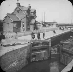 Federation University Historical Collection
Photograph - Glass Plate, Henry Sutton, Hertford Lock by Henry Sutton, c1891
Henry Sutton was born in Ballarat into the musical Sutton Family. He is known as an important Australian inventor. Photograph of Hertford Lock. lockkeepers house. A lock is a device used for raising and lowering boats, ships and other watercraft between stretches of water of different levels on river and canal waterways. Hertford Lock is situated on the River Lea on the eastern side of Hartham Common, Hertford in the English county of Hertfordshire. It is owned and managed by British Waterways and is the first lock of the River Lee Navigation.henry sutton, glass plates, photography, swans -
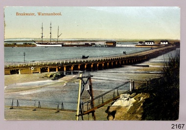 Flagstaff Hill Maritime Museum and Village
Postcard - Historical, maritime, Breakwater, Warrnambool, ca. 1890
The local photograph shows the original footbridge across the Merri River near its mouth, the Viaduct road and the Warrnambool Breakwater with the Titan crane on it. The breakwater's construction was completed in 1890, the year this photograph was taken. The Viaduct has since been filled in to prevent water from passing through the pylons, and the footbridge has been replaced. The postcard has a personal message written on the back to a Dr Scott from May. The photograph is locally significant for recording the completion of the Warrnambool Breakwater, for showing the original design of the Viaduct and for a clear view of the original footbridge across the Merri River. It is also of significance for being used by a female to send a greeting from Warrnambool to a doctor. Postcard, coloured, of the Warrnambool Breakwater, with the Merri River footbridge and the Viaduct in the foreground. Pedestrians and a horse-drawn cart are on the Viaduct, The lifeboat house and other buildings are near the beginning of the Breakwater. A three-masted sailing ship is in port. The photograph was taken from Middle Island. A personal message is written on the back, and a title is printed on the front. Produced in Germany in the 1890s.On the front: "Breakwater, Warrnambool" Written on the reverse: "Warrnambool Wishing Dear Dr Scott the Compliments of the Season With love and best wishes, From May"warrnambool, shipwreck coast, flagstaff hill, flagstaff hill maritime museum, flagstaff hill maritime village, postcard, coloured postcard, warrnambool breakwater, breakwater, viaduct, 1890s, merri river footbridge, dr scott, may -
 Bendigo Military Museum
Photograph - PHOTOGRAPH, FRAMED WW1, Wayne Eels, C.2008/2009
The Grinton Collection. Life after 1919, unloading wood. Refer Cat No. 1280 for Jack Grintons service details.Photograph - Framed. Photograph - black and white photograph on paper depicting an elderly couple unloading wood from a boat on to the river bank. Background - river and trees. Frame - Timber, light varnish finish, Perspex front, cardboard backing."Group 6: Life after 1919". "K. Unloading wood".framed accessories, camera on the somme, ww1, 38th bn, grinton -
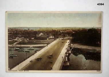 Bendigo Military Museum
Postcard - SOUVENIR POSTCARD, Photochrom Co Ltd, C. WW2
Part of the Frederick Davey DFC RAAF collection. refer Cat No 3536P for his service records.Post card, rectangular shape featuring a colour photograph of a bridge over a river with buildings in the back ground, vehicles are crossing the bridge, boats moored on the river, on the back printed in black type are publication details and space for correspondence and address.postcards, souvenirs, bridges -
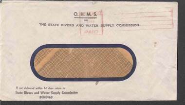 Bendigo Historical Society Inc.
Document - W. BABIDGE COLLECTION: S.R. & W.S.C. ENVELOPE
Window envelope with O.H.M.S. The State Rivers and Water Supply Commission printed in black across the top. Window is buff coloured with dark blue border. State Rivers and Water Supply Commission, Bendigo printed in the bottom left corner.document, w. babidge collection - s.r. & w.s.c. envelope, state rivers and water supply commission, bendigo -
 Bendigo Historical Society Inc.
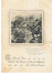
Document - MALONE COLLECTION: GREETING CARDS
Cream card with a 7 x 7 cm black & white scene of The Little Devil River, Victoria. The scene shows the river, trees & rocks. There is a narrow white border around the picture with grey shading. A verse is printed underneath.person, greeting cards, malone collection, malone collection, greeting cards -
8th/13th Victorian Mounted Rifles Regimental Collection
Document - Adventure trg admin instruction
Typed document titled " Adventure training Murray River Marathon in which No 2 Troop A squadron participated in the red Cross Murray River Canoe Marathon from 26-31 December 1983 as adventure training. 4 pages.military, adventure, training