Showing 110498 items matching " roads"
-
 Eltham District Historical Society Inc
Slide, McCarthy Grove, Montmorency looking west near No. 27, c.Oct. 1980
... roads ...One of a series of images of roads and infrastructure taken by Eltham Shire Council Planning and Engineering officers. They provide perspective of the changes in housing styles and road development that began sweeping in from the mid 1970s with increasing urbanisation of what was once more outlying suburbs and regions.35 mm colour positive transparency Mount - Kodak Kodachrome CardProcessed Oct 1980houses, infrastructure, mccarthy grove, montmorency, roads -
 Eltham District Historical Society Inc
Slide, McCarthy Grove, Montmorency looking east towards Reichelt Avenue, near no. 27, c.Oct. 1980
... roads ...One of a series of images of roads and infrastructure taken by Eltham Shire Council Planning and Engineering officers. They provide perspective of the changes in housing styles and road development that began sweeping in from the mid 1970s with increasing urbanisation of what was once more outlying suburbs and regions.35 mm colour positive transparency Mount - Kodak Kodachrome CardProcessed Oct 1980houses, infrastructure, mccarthy grove, montmorency, roads -
 Eltham District Historical Society Inc
Slide, Quinn Estate, McCarthy Grove ext. driveway, Montmorency, near no. 31, c.Oct. 1980
... roads ...One of a series of images of roads and infrastructure taken by Eltham Shire Council Planning and Engineering officers. They provide perspective of the changes in housing styles and road development that began sweeping in from the mid 1970s with increasing urbanisation of what was once more outlying suburbs and regions.35 mm colour positive transparency Mount - Kodak Kodachrome CardProcessed Oct 1980houses, infrastructure, mccarthy grove, montmorency, roads -
 Eltham District Historical Society Inc
Slide, Looking towards 99 Buena Vista Drive, Montmorency, c.Oct. 1980
... roads ...One of a series of images of roads and infrastructure taken by Eltham Shire Council Planning and Engineering officers. They provide perspective of the changes in housing styles and road development that began sweeping in from the mid 1970s with increasing urbanisation of what was once more outlying suburbs and regions.35 mm colour positive transparency Mount - Kodak Kodachrome CardProcessed Oct 1980houses, infrastructure, mccarthy grove, montmorency, roads -
 Kew Historical Society Inc
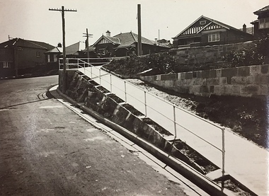
Photograph, City of Kew, Public Works, Road Making, c.1920s
An original photograph donated to the Kew Historical Society by the City's Engineering Department before the amalgamation of Kew into the City of Boroondara in 1994. While not all of the photographs are of Studley Park, Kew or East Kew, each photo provides a fine snapshot of the work of local government engineering departments of the period. They reveal they types of labour conducted, the techniques used and the equipment and machinery in the possession of the local government authority.Public works. A high retaining wall holds back an embankment on a steep slope around which a road turns. It is believed that the photograph dates from the 1920s. Inscription on reverse: "A difficult corner designed to obviate the use of steps. / Pedestrians using the road in front of the dwellings step off the pathway at the telegraph pole".city of kew (engineering department), engineering, road construction building -
 Melbourne Tram Museum
Slide, John Webster, 28/05/1960 12:00:00 AM
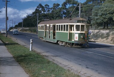
Colour slide, Kodak, white cardboard of Tram 557 waiting on passing loop, Riversdale Road, Wattle Park, outbound to Wattle Park, Elgar Road, route 70/ Has adverts for Coca Cola, 3AW. Also has an Auxiliary board - Football? There is a fire hydrant in the view and the tram stop sign. Slide dated 28-5-1960.Hand writing on rear in ink "28-5-60- Track - Tram 557 waiting on passing loop, Riversdale Road, Wattle Park, Melbourne Vic"trams, tramways, w2 class, wattle park, riversdale rd, route 70, tram 557 -
 Whitehorse Historical Society Inc.
Document, Certificates of Title - Arthur Royle & Robert Driver Thurgood, 1931, 1934
Certificate and TitleCertificate and Title for house and land off L.L. Vale Road, Vermont and correspondence re outstanding rates.Certificate and Title shire of blackburn and mitcham, rates, land titles, royle, arthur, thurgood, robert driver, boronia road, vermont -
 Kew Historical Society Inc
Photograph - 'Raheen', Studley Park Road (Kew), c.1965
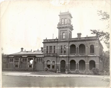
"The first section of Raheen was commenced in 1870 with an extension added in 1884. It was designed by William Salway and built for Edward Latham of the Carlton Brewery. Sir Henry Wrixon, prominent Melbourne barrister and solicitor, later owned and resided at the property. In 1917 Raheen was purchased by the Catholic Church and became the official residence of Archbishop Mannix, as well as four other Catholic archbishops of Melbourne. In 1981 the Church sold the property and it again reverted to a private residence." (Victorian Heritage Database, 2023)This work forms part of the collection assembled by the historian Dorothy Rogers (1905-1973), donated to the Kew Historical Society by her son in 2015. The manuscripts, photographs, maps, and documents were sourced by her from both family and local collections or produced as references for her print publications. Many were directly used by Rogers in writing ‘Lovely Old Homes of Kew’ (1961) and 'A History of Kew' (1973), or the numerous articles on local history that she produced for suburban newspapers. Most of the photographs in the collection include detailed annotations in her hand. The Rogers Collection provides a comprehensive insight into the working habits of a historian from the 1960s to the 1970s. Original, monochrome print copy of a photograph of Raheen in Studley Park Road (Kew). The unrendered red brick house with tower has a toe story section at right with a double colonnade and a single story section at left. The photographs predates the restoration of the gardens and house by te. Pratt family. Annotation verso: "Raheen. R. C. Archbishops Palace, Studley Park Road, Kew".reheen, mansions -- kew (vic.), studley park road -
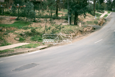
 Eltham District Historical Society Inc
Slide, Main Road, Lower Plenty, 25 Jul 1973
... roads ...This section of Main Road was known by locals as the "Windy Mile" due to its many little wists and turns. It was also the setting for Billy Cart derbies held on special occassions such as the Eltham Easter Gymkhana at Eltham Lower Park. Contestants would line up and race each other down the hill to the finish line at Bolton Street. Main Road, Lower Plenty underwent substantial changes when it was duplicated with the road becoming two lanes each way and split level due to the cross gradient. This particular section running down the hill from Panorama Avenue to Bolton Street with its twists and turns had many of them straightened out during the road widening constuction work.35 mm colour positive transparency Mount - Agfacolor Service (Blue)main road, infrastructure, lower plenty, roads, windy mile -
 Melbourne Tram Museum
Photograph - Black & White Photograph/s, Chris Phillips, Sep. 1969
Black and white photograph, side on view of W5 832 and SW5 847, stored with many other tramcars in Dandenong Road during the reconstruction of the Malvern Tram Depot lead, 14/9/1969. Taken by Chris Phillips, printed on Kodak Paper. Tram 832 has an side panel advertisement for Fosters Lager.On the rear in black ink "Dandenong Road, Tram Depot 14/9/69"trams, tramways, mmtb, malvern depot, dandenong rd, trackwork, tram 816 -
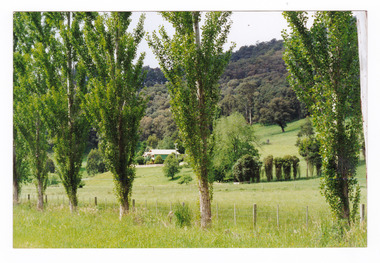
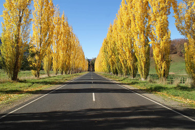 Marysville & District Historical Society
Photograph (Item) - Colour photograph, Unknown
A digital copy of a colour photograph of Gould Memorial Drive which is on the Marysville-Buxton Road near Marysville in Victoria.A digital copy of a colour photograph of Gould Memorial Drive which is on Marysville-Buxton Road just outside Marysville in Victoria. The planting of the avenue of Lombardi Poplars was initiated by Mrs Joy Gould and the trees were planted by workers of the Gould Mill. The intention was for the avenue to extend from Marysville to Buxton. However, this was never fully realised. In Autumn the trees turn a brilliant yellow and are a major tourist attraction. john lloyd gould, joy gould, gould mill, gould memorial drive, marysville-buxton road, marysville, buxton, victoria, photograph, lombardi poplars -
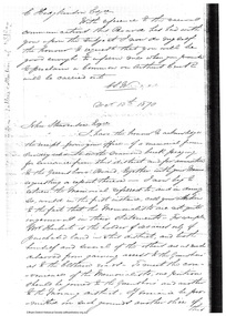 Eltham District Historical Society Inc
Document - Folder, Request for change of boundary, 1870
... roads ...Document dated December 13 1870 re the change of boundary between the Greensborough Road Board and the Eltham Road Boards severance of land East of the Diamond Creek boundary. Photocopy from Letters collection, Shire of Eltham. Folder 81 from Harry Gilham Collection 3 pageswingrove, herbert, alexander donaldson, john stevenson, roads -
 Marysville & District Historical Society
Photograph (Item) - Colour photograph, Unknown
A colour photograph of a house on the Marysville-Buxton Road near Marysville in Victoria.A colour photograph of a house on the Marysville-Buxton Road near Marysville in Victoria.marysville-buxton road, marysville, buxton, victoria, photograph -
Whitehorse Historical Society Inc.
Article, Plans To Consolidate Three Campuses, 21/09/1994 12:00:00 AM
Article on the consolidation of Millauna Secondary Colleges, three campuses on to one site at Mitcham Road, due to operate in 1996.Article on the consolidation of Millauna Secondary Colleges, three campuses on to one site at Mitcham Road, due to operate in 1996.Article on the consolidation of Millauna Secondary Colleges, three campuses on to one site at Mitcham Road, due to operate in 1996.secondary schools, millauna secondary college -
Whitehorse Historical Society Inc.
Map, City of Nunawading Street and Block Map
City of Nunawading Street and Block map.City of Nunawading Street and Block map. Scale: 1:10,000. with enlargement, Canterbury Road South to Burwood Highway.City of Nunawading Street and Block map. canterbury road nunawading, burwood highway burwood east, city of nunawading -
Lakes Entrance Historical Society
Photograph - David Philp Gippsland Road Cycling Champion Wonthaggi South Gippsland, Lakes Post Newspaper, 1/04/1995 12:00:00 AM
David Philp Gippsland Road Cycling Champion Wonthaggi South GippslandBlack and white photograph showing a group of David Philp Gippsland Road Cycling Champion Wonthaggi South Gippslandsports, cycling, recreation -
 Kew Historical Society Inc
Plan, F R Simms & Son, Land for Private Sale: Cnr Victor Avenue and Mont Victor Road, Kew, 1950-1960
George Rimington established The Parkhill Nursery in 1877. By 1910, it was more commonly known as Rimington’s Nurseries and well known for its sale of violets. After World War II, Rimington’s Nurseries were gradually subdivided and sold. The 38 allotments were released in sections, including lots 34 to 36 on the corner of Mont Victor Road and Victor Avenue. Previous lots in the subdivision had bordered Burke Road, Rimington Avenue, Heather Grove, and Stoke Avenue. The selling point as it had been in comparable estates for a century were the proximity to transport, schools and churches, as well as the high location and excellent views. The subdivision plan shows most of the lots in the entire subdivision: 1-11, 13-26, and 34-38. Presumably, lot 12 and lots 27-33 were still to be released.Subdivision plans are historically important documents used as evidence of the growth of suburbs in Australia. They frequently provide information about when the land was sold on which a built structure was subsequently constructed as well as evidence relating to surveyors and real estate and financial agents. The numerous subdivision plans in the Kew Historical Society's collection represent working documents, ranging from the initial sketches made in planning a subdivision to printed plans on which auctioneers or agents listed the prices for which individual lots were sold. In a number of cases, the reverse of a subdivision plan in the collection includes a photograph of a house that was also for sale by the agent. These photographs provide significant heritage information relating house design and decoration, fencing and household gardens.Subdivision plan advertising five superb home sites among lots in Burke Road, Stoke Avenue, Victor Avenue, Mont Victor Road and Heather Grove.subdivision plans - kew, rimington avenue -- kew (vic.), heather grove -- kew (vic), stoke avenue -- kew (vic.), burke road -- kew (vic.), mont victor road -- kew (vic.) -
 Kew Historical Society Inc
Photograph, J F C Farquhar, A View in Studley Park Road, 1891
At the beginning of the 1890s, the Kew businessman and Town Councillor, Henry Kellett, commissioned J.F.C. Farquhar to photograph scenes of Kew. These scenes included panoramas as well as pastoral scenes. The resulting set of twelve photographs was assembled in an album, Kew Where We Live, from which customers could select images for purchase.The preamble to the album describes that the photographs used the ‘argentic bromide’ process, now more commonly known as the gelatine silver process. This form of dry plate photography allowed for the negatives to be kept for weeks before processing, hence its value in landscape photography. The resulting images were considered to be finely grained and everlasting. Evidence of the success of Henry Kellett’s venture can be seen today, in that some of the photographs are held in national collections.It is believed that the Kew Historical Society’s copy of the Kellett album is unique and that the photographs in the book were the first copies taken from the original plates. It is the first and most important series of images produced about Kew. The individual images have proved essential in identifying buildings and places of heritage value in the district.This is the earliest known photograph of the exterior of Byram (later Tara Hall). It shows the original red brick fence, its asymmetrical gate and gateposts, with a large terra cotta gargoyle surmounting the higher of the two. The architect, Edward Kilburn designed Byram in the Arts & Crafts style for the industrialist George Ramsden. Construction began in 1888 and was reputed to have lasted three years. The mansion had frontages to Studley Park Road and Stevenson Street, including gardens laid out with great taste, including pleasure grounds, tennis lawn, fruit and flower garden, and paddock. The size of many of the trees in the garden indicate that many survived from the garden of Clifton Villa, the previous single-storeyed house built on the site by the Stevenson brothers. Byram had views to Melbourne and Port Phillip Bay. The house was demolished in 1960, despite opposition from the National Trust (Victoria), and its gardens subdivided into residential allotments.A View in Studley Park Roadkew illustrated, kew where we live, photographic books, henry kellett, byram, tara hall, goathlands -
 Melbourne Tram Museum
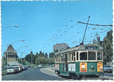
Postcard - Nu-color-Vue - St Kilda Road, Shrine of Remembrance W5 834, Nucolorvue Publishing, 1970s
Postcard - image looking south in St Kilda Road, with the Shrine of Remembrance and BP House in the view. Tram W5 834 (East Malvern Darling Road Route 3).Demonstrates an iconic Melbourne image, St Kilda Road, the Shrine and a W class tram.Postcard colour - serrated edge, Nu-color-Vue - St Kilda Road, Shrine of RemembranceW5 834, ML 132,, Divided back.trams, tramways, shrine of remembrance, st kilda road, sw5 class tram, tram 834 -
 Melbourne Tram Museum
Postcard - Shrine of Remembrance, St Kilda Road and W class trams, Australia Post, 1990
Postcard - an image of Shrine of Remembrance, St Kilda Road with three W class trams in the view. The postcard has had postage including international or worldwide prepaid. The stamp is 65c, the ANZAC tradition. The reference gives the date of the stamp as April 1990. Two of the trams: SW6 918 (Malvern Burke Road, Route 5), and SW6 944 (Toorak Glenferrie Road, Route 8). Another W class tram is behind.Demonstrates an iconic Melbourne image, the Shrine of Remembrance and W class trams in St Kilda Road.Postcard colour - Shrine of Remembrance, St Kilda Road and W class trams - with pre paid postage. Australia Posttrams, tramways, st kilda road, sw6 class trams, tram 918, tram 944, australia post, shrine of remembrance -
 Geelong Cycling Club
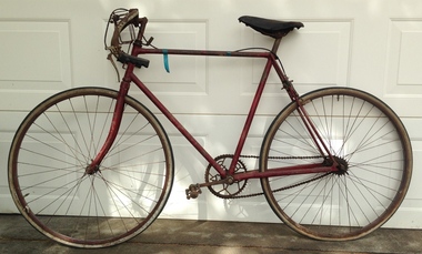
Road Cycle, 1920
This is a Bluebird road cycle made in 1920 by Alan Lowndes from Modewarre. It was purchased by Ray Kinleyside (secretary of the Geelong West Amateur Cycling Club) after WWi in the 1920s.An example of road cycles commonly used in the 1920s.Unrestored road cycle painted red. It is a single brake, single speed bicycle. alan lowndes; ray kinleyside; bluebird road cycle; geelong west amateur cycling club; geelong cycling club; road cycle; -
 Eltham District Historical Society Inc
Photograph, Beard Street, Eltham, 3 Sep 1981
... roads ...Roll of film taken by Eltham Shire Council officers of roads and houses in the Eltham East area, 3 September 1981 prior to construction of new water main; including views of existing damage to footpaths and gutters and general views of Beard Street. These images provide a perspective of housing estate developments and changes in housing styles and road development which began sweeping in from the mid 1970s with increasing urbanisation of what was once more outlying suburbs and regions.35mm colour positive transparency (1 of 28) Mount - Kodak Kodachrome Cardeltham, infrastructure, roads, beard street -
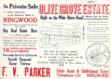 Ringwood and District Historical Society
Flyer, Land Sale Advertisement, Olive Grove Estate, Ringwood, Vic. - 1926
Further development of 9 shop sites took place along Whitehorse Road (later street numbers 58 to 64 Whitehorse Road) between New Street and Olive Grove around 1950 - See Victorian Collections reference 5227.Single sided page with red and blue print advertising Olive Grove Estate business and residential allotments, including subdivision plan and summary of local services.Subdivision includes Whitehorse Road, New Street, and Olive Grove. Agent - F.V. Parker, Telephone 131, Ringwood. -
 Ballarat Tramway Museum
Photograph - Black & White Photograph/s - set of 3, Ellen Butland, early 1970's?
Set of three black and white prints of MMTB Scrubber No. 8 early 1970's. .1 - Arts Centre area, St Kilda Road .2 - Dandenong Road, about to use the crossover just to the west of Glenferrie Road .3 - using the crossing. Has the Hoyts picture theatre on the corner of Glenferrie and Dandenong Roads in the background. On Agfa paper. Photo by E. G. Butland - Ron Scholten - provided a written note re Ellen Butland - in with worksheet - 5th women driver in Melbourne, worked from Kew, now lives in NZ and drove buses in Auckland. See Donated by Ron Scholten to BTM 11/2005 See Destination City - renumbering of No. 8 to 8W took place during 1975.1 - "E.G. Butland" stamped in black ink on rear. .2 - as above, "Wattletree Road" stamped in public in three places, along with address blacked out and the words "please return to" in pencil and in the top left hand corner "No.8 Victoria Pde" in pencil. .3 - "E.G. Butland" stamped in black ink on rear., "D. Menzies / 237 Wattletree Road, Malvern Vic. 3144."tramways, trams, scrubber tram, dandenong road, st kilda road, tram 8, tram 8w -
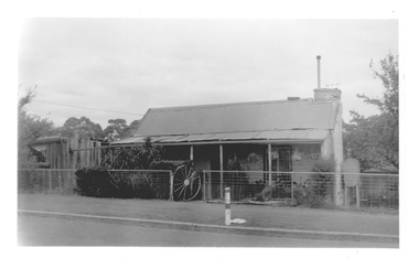 Tarnagulla History Archive
Photograph of cottage with wagon wheel gate, Tarnagulla, Late 1960s
Murray Comrie Collection. Building is still on Commercial Road and in 2019 is a private residence. History to be confirmed.Monochrome photograph depicting a cottage with wagon-wheel gate, which is located at 107 Commercial Road, Tarnagulla.tarnagulla, commercial road, buildings, houses -
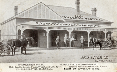 Lakes Entrance Historical Society
Postcard - All Nations Hotel, 1910c
M.S McLeod, Licensee. One mile from wharf, Main Road to Buchan Caves, Orbost and Lake Tyers. Fishing, Shooting, Boating. Vehicle meets steamer nightly. Splendid Accommodation for Tourists. Tariff 30/- a week, 6/- a day.This is the before paired photograph used in the 150 year, Lakes Entrance 1858-2008 display.Also one 12 x 16 framed photograph used in room displayBlack and white postcard of All Nations Hotel, Cunninghame, showing weatherboard building, hipped roof with gable on left side. Roofed veranda across front. Two doors and two sash windows at front. Two bench seats on veranda. Three chimneys. Two horse drawn carriages standing on road, three men and one woman standing before the hotel. Lakes Entrance VictoriaOne Mile from Wharf. Main Road to Buchan Caves, Orbost and Lake Tyers Fishing, Shooting, Boating etc. Vehicle Meets Steamer Nightly. Splendid Accommodation for Tourists. Tariff 30/- a week. 6/- a dayhouses, architecture, transport, room display -
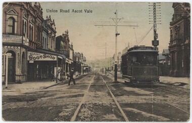 Emerald Museum & Nobelius Heritage Park
Postcard - Postcard of Union Road Ascot Vale, c. 1900s
These postcards are part of an album of postcards which date from late 19th century to mid 20th century.This postcard is in an album of postcards dating from the late 19th century to mid 20th century and, as such, indicate the popularity of collecting postcards in Australia which reached a height in the early 1900s until around 1920.This postcard depicts Union Road, Ascot Vale in the c.1890s-1900s.Front, top: 'Union Road Ascot Vale' Back, top: 'POST CARD' Back, far left, vertical: ' H. V. J. Series' Back, left: 'This space may be used for communication' Back, bottom left: 'Made in Germany' Back, right: 'For Address only.'postcard, 1900s, "green postcard album" -
Whitehorse Historical Society Inc.
Document, A Vermont Memory, 2007
Recollections of Ian Nethercote of the Gallus family.Recollections of Ian Nethercote of the Gallus family who owned a poultry farm on the corner of Boronia and Centre Roads, Vermont.Recollections of Ian Nethercote of the Gallus family. nethercote, ian, gallus, e. e., gallus, dianne, gallus, cynthia, poultry farms