Showing 29723 items matching " the south or k k shaft"
-
 Federation University Historical Collection
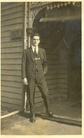
Photograph - Photograph - black and white, Lin Jenkins, Frank Wright at Doveton Street South, Ballarat, 23/07/1921
Frank Wright was a renown resident of Smeaton, where he was born. He lived at Laura Villa, and attended Smeaton State School. His father William was a gold miner and his mother's name was Sarah. Their family won many singing and instrumental awards. Frank was tutored by Percy Code and became the Australian Open Cornet Champion by the age of eighteen. A year later, Frank conducted the City of Ballarat Band, and later the Ballarat Soldiers’ Memorial Band. He formed the Frank Wright Frisco Band and Frank Wright and his Coliseum Orchestra. These bands won many South Street awards, and Frank as conductor won many awards in the Australian Band Championship contest. In 1933 Frank Wright sailed to England to conduct the famous St Hilda’s Band and was later appointed Musical Director of the London County Council, where he organized many amazing concerts in parks, in and around the London district. He was made Professor of Brass and Military Band Scoring and conducted at the Guildhall of Music and Drama. Frank was often invited to adjudicate Brass Band Championships around Europe, in Australia, including South Street and in New Zealand. The Frank Wright Medal at the Royal South Street competition is awarded to an individual recognized as making an outstanding contribution to brass music in Australia.Black and white photograph of a man with one hand in the pocket of his suit trousers, standing before the front porch of a timber house. There is some wrought iron over the entrance to the porch. The man is Frank Wright and the house is at 118 Doveton Street South, Ballarat.Handwritten on the back - Frank Wright, at the age of 19 years taken at 118 Doveton St Sth, Ballarat, by Lin Jenkins, 23-7-1921frank wright, lin jenkins, timber house, wrought iron, ballarat -
 National Wool Museum
Photograph, Sterling Silver Ewer
Sterling Silver Ewer Trophy won by Grainy Point Biswrath for Champion Merino Ram at the 2nd A.S.B.A Show in 1989. Made in 1878 by Martin Hall and Co. of Sheffield England from silver mined in South Africa. Used in the NWM Woolbrokers office display.Sterling Silver Ewer Trophy won by Grainy Point Biswrath for Champion Merino Ram at the 2nd A.S.B.A Show in 1989. Made in 1878 by Martin Hall and Co. of Sheffield England from silver mined in South Africa.merino sheep agricultural shows, elders limited, merino sheep, agricultural shows -
 8th/13th Victorian Mounted Rifles Regimental Collection
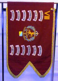
Flag - Guidon 8th, 1980 circa
A guidon is the regimental banner or flag carried by a regiment of light cavalry or light horse. The 8th light Horse (Indi) Regiment was presented with the guidon circa 1927. The actual date is not certain. The guidon carries the battle honours accorded to the regiment for service in the South African War (1899-1902), World War One (!914-1918) and World War Two (1939-1945). The guidon passed into the custody of the 8th/13th Victorian Mounted Rifles Regiment when it was raised on 1 May 1948. At Federation, the Victorian Mounted Rifles companies in North East Victoria were reorganised into the 8th Light Horse Regiment. In 1912 the regiment was renumbered 16th Light Horse. The 8th Light Horse Regiment AIF was raised at Broadmeadows Victoria in September 1914 under the command of Lieutenant Colonel Alexander White and formed part of the 3rd Light Horse Brigade. The regiment served at Gallipoli where in a courageous but ill-fated charge at the Nek on 7 August 1915 it suffered horrendous casualties including Lieutenant Colonel White. Rebuilt in Egypt under the command of Lieutenant Colonel Leslie Maygar VC the regiment went on the serve throughout the Middle East Campaign. Colonel Maygar died of wounds at Beersheba when the regiment was attacked by enemy aircraft while waiting to follow up the successful charge of the 4th LH Brigade on 30 October 1917. The 8th Light Horse AIF was disbanded in 1919, but soon after re-raised as the 8th (Indi) Light Horse in the Citizen Military Forces, superseding 16th (Indi) Light Horse. It had its headquarters at Benalla with sub-units throughout the Upper Murray and Northeast Victoria. In December 1941, the regiment converted from horse to mechanised, initially as 8th Reconnaissance Battalion then in July 1942 it became 8th Cavalry Regiment and served in Northern Territory. As Japanese threat to the mainland declined the regiment was disbanded. In 1948, the 8th Light Horse was linked with 13th and 20th Regiments to form the 8/13 Victorian Mounted Rifles in the Citizen Military Forces. Guidon of the 8th Light Horse Regiment. Maroon corded cotton double thickness fabric with gold metal thread fringe, gold embroidered regimental number in Roman numerals, regimental badge and battle honours; colour patch below badge. Braided corded with tassels.Battle honours: "South Africa 1899-1902, Sari Bair, Maghdaba-Rafah, Jerusalem, Megiddo, Damascus, Defence of ANZAC, Rumani, Gaza-Beersheba, Jordan (Es Salt), Sharon, South West Pacific 1943-1944"guidon, 8th light horse, battle honours -
 Ballarat Tramway Museum
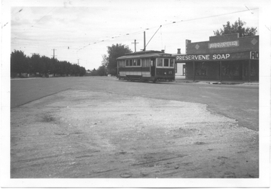
Photograph - Digital image, Wal Jack, 17/01/1945 12:00:00 AM
Yields information about the intersection of Drummond and Skipton St intersection in 1945.Digital image from the Wal Jack Ballarat Album of a photograph of No 25 in Drummond St South turning into Skipton St, enroute to Sebastopol, 17-1-1945, Wal Jack photograph. In the background, is the J.P. Ditchfield shop, advertising Preservene Soap on the front. See image i2 for rear of photograph. See image i3 for hi res scan of print. See image i4 for hi res scan of negativeOn rear of photograph in ink "SEC, Ballarat No. 25 in Drummond St South and about to turn into Skipton St at Darling St, 17-1-45" and in top right hand corner, Wal Jack stamp with "T70" written in.trams, tramways, sebastopol, drummond st sth, skipton st, tram 25 -
 The Beechworth Burke Museum
Photograph
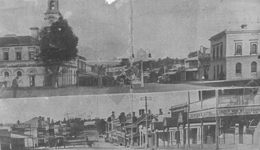
This item has two photographs split horizontally. The top photograph was taken of Camp Street, Beechworth, looking south and the bottom image was taken of Ford Street, Beechworth, looking east.Black and white photograph printed on matte photographic paper. Obverse: Camp Street looking South / Ford Street looking East / Reverse: 1997.3095 / AO3192 / PH 77 / post 1906. / GH. Farley listed 1917-1918. / around 1910. See Camp St. Photo of Coronation arch Showing street lamp beechworth, camp street, ford street, burke museum -
 Clunes Museum
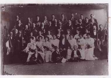
Photograph, RICHARDS & CO
ORCHESTRA CONTAINING HALLAM FAMILY - GREAT UNCLES AND AUNTS OF DORETHEA JUNE CHURCHES. HALLAMS - AUGUSTUS, EMILY GEORGE AND SISTER (FIRST NAME UNKNOWN). SHE IS SEATED FRONT ROW CENTRE (WITH SPECTACLES) LEFT OF GENTLEMAN. YOUNG VIOLINIST SEATED ON FLOOR RIGHT SIDE IN PHOTO IS BERNARD HEINZ - LATER SIR BERNARD HEINZ - CONDUCTOR OF ORCHESTRAL FAME.ORIGINAL SEPIA PHOTOGRAPH MOUNTED ON CARDBOARD ORCHESTRA AT BALLARAT SOUTH STREET COMPETITION. SEATED IN FRONT ON RIGHT HAND SIDE OF PHOTOGRAPH IS BERNARD HEINZ, LATER SIR BERNARD HEINZ,CONDUCTOR OF ORCHESTRAL FAME.On Reverse in pencil; Ballarat Lyric Orchestra Winner 1st Prize South Street Competition In blue biro; Hallam Family - Great Uncles & Aunts of Dorethea June Churches Hallams - Augustus, Emily, George & sister (first name unknown), she is seated front row centre (with spectacles) left of gentleman Young violinist seated on floor right side in photo is Bernard Heinz (Heinze) - later Sir Bernard Heinze conductor of orchestra famelocal history, photography, photographs, music, orchestra -
 Bendigo Historical Society Inc.
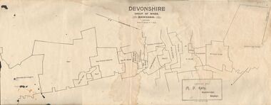
Map - DEVONSHIRE GROUP OF MINES BENDIGO
Map showing the mining leases that include the Devonshire group of mines - leases shown from north to south are: Catherine Reef United , William United, Ellenborough, Sadowa, St. Mungo, Lady Barkly, South St. Mungo, Phoenix, United Devonshire, Duchess of Edinburgh, New St. Mungo, South Devonshire, Extended South Devonshire, New Victoria Catherine, Pearl, Hercules and Energetic.Issued by M. P. Kelly, Sharebroker, Bendigomap, bendigo, goldfields, catherine reef united , williamd united, ellenborough, sadowa, st. mungo, lady barkly, south st. mungo, phoenix, united devonshire, duchess of edinburgh, new st. mungo, south devonshire, extended south devonshire, new victoria catherine, pearl, hercules and energetic. mining, gold mines -
 Orbost & District Historical Society
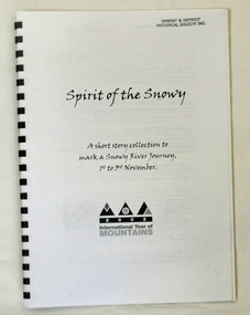
book, Spirit of the Snowy, 2002
This book was compiled to mark a three day journey along the Snowy River in 2002. It was part of the International Year of the Mountain. Graeme Enders is Manager South West regional operations at N.S.W. Office of Environment & Heritage.A spiral bound book with a plastic cover. It is titled Spirit of the Snowy and is a collection of short stories written to mark a Snowy River journey from 1st to 3rd November in 2002. The book was edited by Graeme Enders of the Snowy River Recovery Project and published by the New South Wales Premier's Dept. It contains poetry, stories and recollections.2002 International Year of Mountainssnowy-river -
 Flagstaff Hill Maritime Museum and Village
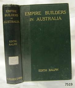
Book, Empire Builders In Australia
Empire Builders In Australia Early Days in New South Wales, Victoria and South Australia Author: Edith Ralph Publisher: T. Fisher Unwin Date: 1911Label on spine cover with typed text R.A. 994.02 RAL Pastedown front endpaper has sticker from Warrnambool Mechanics Institute and Free Librarywarrnambool, shipwrecked-coast, flagstaff-hill, flagstaff-hill-maritime-museum, maritime-museum, shipwreck-coast, flagstaff-hill-maritime-village, shipwrecked-artefact, book, warrnambool mechanics’ institute, empire builders in australia -
Port Melbourne Historical & Preservation Society
Booklet, Robin Grow, South Melbourne Walk, 2008
With assistance from PMH&PS, Robin Grow constructed an art deco walk and booklet, one of a series produced by the Art Deco Society..02 - "South Melbourne Walk", a booklet produced by the Art Deco Society, on inter-war building in South Melbourne. A 30 pp self-guiding reference, 2008architecture, built environment, robin grow, art deco society, walk guide -
 Australian Army Museum of Western Australia
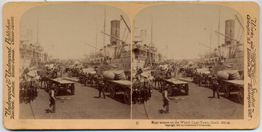
Stereographic Image, 1900
Busy scenes on the Wharf, Cape Town, South Africa Stereoscope #6 from a boxed set "For Queen and Flag: South Africa 1900" by Underwood and Underwood, Publishers Works and Studios: Arlington NJ; Littleton NH; Washington DCstereoscope, boer war, south africa, capetown -
 Melbourne Tram Museum
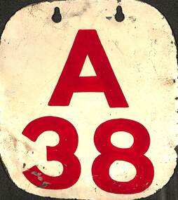
Sign - Run Number Plate A38
Run Number pressed metal plate with corners trimmed and rounded, top section with two slotted holes, painted with a white background and the letter "A" and number "38" painted in red, to give a Run Number Plate for South Melbourne Depot. Painted with the same detail on either side of the plate.Used by South Melbourne Depot until they were phased out and replaced with the Automatic Vehicle Monitoring system c1990. Used to identify the depot and "run number" or timetable that the tram was running on, two in each tram, to enable monitoring by inspectors and crews.Run Number pressed metal plate with corners trimmed and rounded, top section with two slotted holes, painted with a white background and the letter "A" and number "38" painted in red, to give a Run Number Plate for South Melbourne Depot. Painted with the same detail on either side of the plate.tramways, trams, signs, south melbourne, south melbourne depot, run number plates, timetables -
 Glen Eira Historical Society
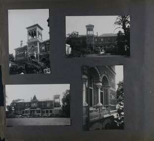
Album - Album page, Ripponlea, 192 Hotham Street, Circa 1972
This photograph is part of the Caulfield Historical Album 1972. This album was created in approximately 1972 as part of a project by the Caulfield Historical Society to assist in identifying buildings worthy of preservation. The album is related to a Survey the Caulfield Historical Society developed in collaboration with the National Trust of Australia (Victoria) and Caulfield City Council to identify historic buildings within the City of Caulfield that warranted the protection of a National Trust Classification. Principal photographer thought to be Trevor Hart, member of Caulfield Historical Society. Most photographs were taken between 1966-1972 with a small number of photographs being older and from unknown sources. All photographs are black and white except where stated, with 386 photographs over 198 pages.From Victorian Heritage Database citation for Rippon Lea H0614 https://vhd.heritagecouncil.vic.gov.au/places/427(as at 23/10/2020) Rippon Lea was commenced in 1868 by Frederick Sargood, a most successful politician and merchant. He was born in England in 1834 and arrived in Melbourne in 1850. He soon joined his father's wholesale soft goods firm, spending some time as its manager on the goldfields. Sargood entered the Legislative Council in 1874. He was Victoria?s first Minister for Defence in 1883. Sir Frederick Sargood was created CMG. In 1885 and KCMG in 1890 as a reward for his contribution to public life. He died suddenly in 1903. Rippon Lea was designed by the leading firm of architects, Reed and Barnes. Joseph Reed had travelled in Europe in 1863, including northern Italy. When he returned he introduced the use of polychromy. While not the first examples, Rippon Lea and the Independent Church in Collins Street were the best and set a fashion which became a distinctly Melbourne style, particularly used for houses and churches. Its popularity was possible because of the new availability of different coloured bricks. Reed's fine Lombardic Romanesque details soon became debased by others. As Sargood's family grew and his fortunes prospered, Rippon Lea was extended to include 33 rooms - a complete mansion. The cast iron porte cochere and the northern conservatory were added in 1897. The architects were Taylor and Fitts. The ballroom was added in 1882 and remodelled in 1889. Many alterations have changed the interior and exterior during the ownerships of Benjamin Nathan and later his daughter Mrs Louisa Jones in the 1930s and are in their own right of significance. Sir Thomas Bent owned the property from 1903 until 1911 but never lived there. He subdivided much of the land. The original garden dates from about 1868, and it seems that William Guilfoyle of the Botanic Gardens was involved. It was redesigned in a more natural style in the 1880s by Sargood and his head gardener, Adam Anderson. The lake, waterfalls, fernery, hill and grotto are balanced by mighty deciduous trees and conifers. These are interspersed with, but never dominated by Australian species such as eucalyptus and other exotics. The sinuous drive with its carefully prepared approach to the house is notable. The original vegetable gardens, orchard and outer paddocks no longer survive. The shade house is important as the largest known in Australia and possibly the world. Its curved plan and form of construction are particularly notable. It was built about 1884.Page 91 of Photograph Album with four photographs (two portrait and two landscape) of various external views of Ripponlea.Handwritten: SOUTH [under top left photo] / SOUTH [under top right photo] / WEST [under bottom left photo] / 91 [bottom left]trevor hart, elsternwick, mansion, hotham street, frederick sargood, reed and barnes, cast iron porte cochere, conservatory, 1860's, 1890's, ballroom, 1880's, benjamin nathan, louisa jones, thomas bent, sir thomas bent, william guilfoyle, adam anderson, lake, grotto, shade house, portico, ripponlea, victorian, sir frederick sargood, architects, taylor and fitts, rippon lea, polychrome bricks, lombardic romanesque style -
 Mont De Lancey
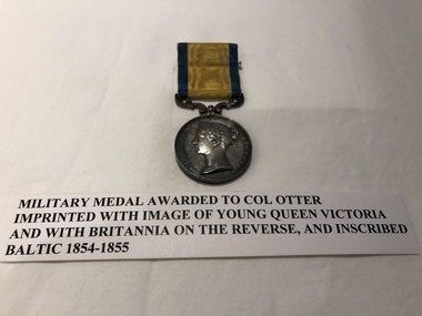
Military Medals
Awarded to Colonel Otter.4 round, silver Military Medals attached to striped ribbon Bars:- 1. Silver Medal with image of young Queen Victoria, & Britannia on the reverse. 2. Silver Medal with image of Queen Victoria, & Lion & Bushes on the reverse. 3. 1 large Silver Medal with image of Queen Victoria, & Britannia on the reverse. 1 smaller replica Medal of the larger Medal.1. Baltic 1854-1855 2. South Africa 1877-1878 3. South Africa 1901 Transvaal, Orange Free State, and Cape Colonymilitary medals -
 Wodonga & District Historical Society Inc
Map - Australia Shewing the Tracks of the Late Explorers
Charles George Eastland Platts arrived in South Australia on 22 March 1839, and soon after established his business in Adelaide. He became Adelaide’s first bookseller. It was known as Platts’ Library but was also a bookshop and stationer. His business was also used as a postal receiving house. Platts died on 14 November 1871. Boyle Travers Finniss (18 August 1807 – 24 December 1893) had an early career in the British Military before selling off his commission in 1835. He was appointed assistant surveyor to Colonel William Light in South Australia. He then had several roles in public service. Finniss was the first premier and Chief Secretary South Australia, serving from 24 October 1856 to 20 August 1857. In 1864 he was appointed as the Government Resident of the Northern Territory. He was filling this role at the time when the map was produced and is acknowledged on the map.This is a very early map documenting the exploration and opening up of Australia.Map of Australia and part of Indonesia. Part coloured with tracks of 15 explorers including Eyre, Stuart, Leichhardt and Burke and Wills with notes and some details of latitude and longitude. Relief relating to the major mountain ranges is indicated. At the bottom of the map is a key to the explorers and a list of the counties in the different states. Top left side of map has small sketch of the Platts (publisher) building at the corner of King William Street.Map of Australia shewing the tracks of late explorers into the interior and across the continent together with their discoveries map/ projected, compiled and drawn by O.W.O. Bennett Most Respectfully Dedicated to LIEUT. COL. BOYLE TRAVERS FINISS Government Resident of the Northern Territory of SOUTH AUSTRALIAexplorers -- australia -- maps, rare maps australia -
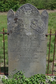 Ballarat Heritage Services
Photograph - Colour, Rees Headstone at the Franklinford Cemetery, 2015, 25/10/2015
William M. Rees was born at Gwter Fawr Gaermarthen Shire, South Wales"Sacred to the memory of Elizabeth W. Rees daughter of William and Margaret Rees. Yandoit Late of Chewton who died 31th (sic) 1866. Aged 3 years and 4 months. Also the aforesaid William M. Rees. Late of Gwter Fawr Gaermarthen Shie, South Wales. Who died Oct 10th 1868 aged 55 years. And Elizabeth Rees born May 9th 1866. Died March 8th 1870. Aged 3 Years and 10 months. frankinford cemetery, gwter fawr gaermarthen shire, south wales, william m. rees, elizabeth w. rees, elizabeth rees, yandoit, chewton, welsh, welsh language -
Whitehorse Historical Society Inc.
Document, Slater Family, 05/03/1996 and/12/1994
William Henry Slater of Mitcham, Surrey : an Australian pioneer. Notes by Eric Montague 05/03/1996 with an article ' A Mitcham Life' by Paul Parry from 'Merton Messenger' December 1994 on members of the Slater family, lavender growers.William Henry Slater of Mitcham, Surrey : an Australian pioneer. Notes by Eric Montague 05/03/1996 with an article ' A Mitcham Life' by Paul Parry from 'Merton Messenger' December 1994 on members of the Slater family, lavender growers. Includes photograph of William Mitchell. Note: Article refers also to Mitcham England. The photo of the Mayor Lyndon Parnell refers to Mitcham, South Australia.William Henry Slater of Mitcham, Surrey : an Australian pioneer. Notes by Eric Montague 05/03/1996 with an article ' A Mitcham Life' by Paul Parry from 'Merton Messenger' December 1994 on members of the Slater family, lavender growers.herb farms, slater, william henry, mitcham, slater, benjamin, skater, daniel, mitcham, surrey, england -
Federation University Historical Collection
Document - Reports, Martin Westbrooke, Nanya Station
Nanya Station, owned and managed by the University of Ballarat (now Federation University Australia), was purchased with assistance from the Department of Environment and Heritage Government Caring for our Country program. Nanya Station is located in the Scotia country, west of the Darling Ana-Branch in far western New South Wales and consists of the Nanya Western Lands Pastoral Lease 3281 – Perpetual Leasehold Lot 1244 in Deposited Plan 762778, Parish of Winnebaga, County of Tara and part of Lot 1242 County of Windeyer. Nanya is within the tribal area of the Danggali Aboriginal people, a sub-group of the Barkindji. Many Aboriginal sites have been recorded adjacent to major rivers in the region providing evidence that these areas supported a large population. The Scotia region has one of the shortest stock grazing histories of western NSW. Along with five other Scotia properties, Nanya was created as a pastoral lease in 1927. The first European settlement on the land followed exploration of the area by Sturt and Eyre. In 1854, the Lake Victoria lease which encompassed this area comprised 465,000ha.included Scotia blocks 1, 2, 3 and 4, Amoskeag and Winnebaga which formed the area known as the Scotia. It was described as a region of thick mallee scrub, interspersed with bluebush flats and Belah woodland. In the 1920s artesian water was found and the dry Scotia country was surveyed and divided into six Homestead leases allocated by ballot (Withers 1989). All properties were approximately 30,000ha, with a recommended stocking level of 3,000 sheep. Winnebaga (renamed Nanya) was taken up by Gordon Cumming. He initially dug a dam near the southeast corner of the property. A larger ground tank and rudimentary dwelling at the site of the present complex was later established. An adjacent area was cleared and cropped to provide feed for the horses used in digging the earth tanks. The ruins of the original building are located between the shearing shed and Homestead Tank. A cottage was built in the 1930s and a more substantial Red Gum framed homestead in the early 1950s. The lease was held by Mr Gordon Cumming until 1984 when it was purchased by Mr Norm Scadding as an extension to the adjacent lease, Belvedere. It was sold in 1995 to Mr Rob Taylor of Waikerie then in 1999 to BeMax Pty. Ltd., a sand mining company. These last three owners all permitted use of the property by the University for teaching and research. The Centre for Environmental Management at the University of Ballarat had been involved in studies of flora and fauna in western New South Wales since 1988. Studies became concentrated on the Scotia region with its variety of intact ecosystems due to a short pastoral history. Of particular significance is a system of natural salt lakes of which the most extensive is the Scotia Discharge Complex located on Nanya Station. An extensive vegetation survey of the Scotia region Westbrooke et al. 1998) highlighted the significance of the area both in terms of the range of communities in relatively intact condition and the occurrence of species and communities of restricted distribution. Nearly 400 species were recorded of which nine had either not previously been recorded or have restricted distribution in western NSW. Twenty-two plant communities occur on Nanya Station of which two, Halosarcia lylei low open shrubland and Hemichroa diandra/Halosarcia/Frankenia low open shrubland, are dominated by species not previously recorded from NSW. H. lylei and Acacia loderi shrublands are listed as endangered under the NSW Threatened Species Conservation Act. As noted, the area has a relatively short grazing history and, due to the presence of large areas of mallee with a Triodia understorey and restricted water supplies, stocking rates have been low. The diversity of ecosystems in relatively intact condition and extensive areas of old growth mallee made Nanya a highly significant refuge for biological diversity. This factors led to the purchase of Nanya Station by the University of Ballarat in 2004 with the assistance of the Department of Environment and Heritage for the purposes of conservation, research and education. In 2010 the southern paddocks of Nagaella Station (10,000ha.) which lie along the northern boundary, were purchased with the assistance of Lower Murray Darling Catchment Management Authority and added to the Nanya lease to provide complete protection for the communities of the Nanya Discharge Complex and further high quality Malleefowl habitat. Four digital reports documents relating to Federation University's Nanya Station, Western New South Walesnanya station, scotia country, pastoral lease, winnebaga county, darling ana-branch, martin westbrooke, environmental education, nagaella station, lower murray darling catchment management authority, conservation research education, ian gribble, pat prevett, ian henderson, danggali -
Mission to Seafarers Victoria
Drawing, XMAS 1946, 1946
Drawing (0341.C1) by Allan Quinn of South America. Titled 'XMAS 1946'. south america, brazil, argentina, allan quinn, letter, 1946, christmas, sketch, drawing, sailors, seamen, seafarers, tourism -
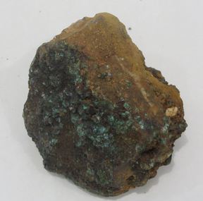 Federation University Historical Collection
Rocks, Azurite and Malachite Specimens, Moonta, South Australia
From the Ballarat School of Mines.Azurite and Malachite Specimens (and iron), Moonta, South Australiageology, rock, azurite, malachite, moonta -
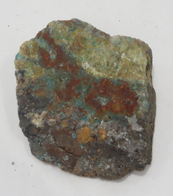 Federation University Historical Collection
Geological specimen - Rocks, Copper Specimen, Broken Hill, New South Wales
From the Ballarat School of Mines.Copper Specimen, Broken Hill, New South Walesrocks, geology, copper, broken hill -
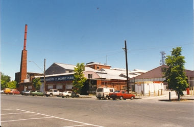 Federation University Historical Collection
Photograph, Former Ballarat Brewing Company Pre-demolition
Ballarat Brewing Company in from Lydiard Street South.ballarat brewing company, chimney, brew tower, lydiard street south -
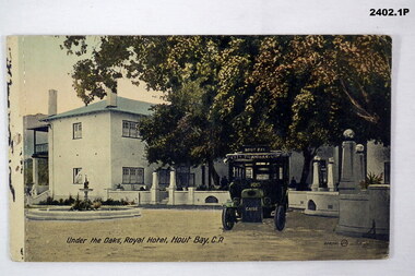 Bendigo Military Museum
Postcard - POSTCARDS, SOUTH AFRICA, The Valentine & Sons Publishing Co Ltd, c.1916
Sent by FRANK BARNES (AIF 4156) to UNA FRANKLING of Harcourt. Refer Cat No 2380 for details re Frank Barnes service.Rectangular postcards, hand coloured photographs of South Africa.2402.1 “Under the Oaks, Royal Hotel, Hout Bay CA” 2402.2 “Birds, Groote Schour, CP” 2402.3 “Clifton-on-Sea, CP”documents - photographs, postcards -
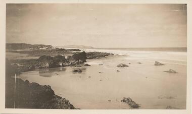 Phillip Island and District Historical Society Inc.
Photograph, Unknown
One of 6 photographs donated by M. BattyBlack & White photograph of the South Coast of Phillip Island.phillip island coastline, south coast phillip island, phillip island, m batty -
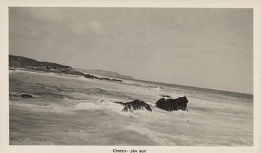 Phillip Island and District Historical Society Inc.
Photograph, 01/1938
One of 8 photographs donated by Joseph WhiteBlack & White photograph of the South Coast of Phillip Island"Cowes - Jan 1938"phillip island coastline, south coast phillip island, shoreline phillip island, joseph white -
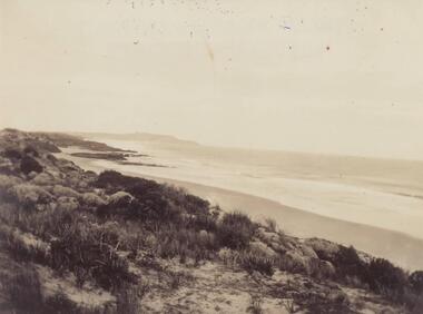 Phillip Island and District Historical Society Inc.
Photograph, Early 20th Century
One of a collection of 6 photographs donated by Mary KarneyBlack & White photograph of the South Coast of Phillip Islandphillip island coastline, south coast phillip island, mary karney -
 Phillip Island and District Historical Society Inc.
Photograph
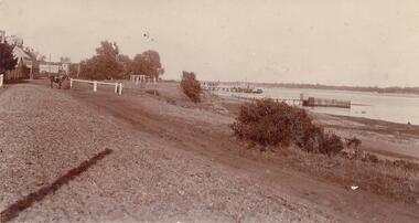
One of a collection of over 400 photographs in an album commenced in 1960 and presented to the Phillip Island & Westernport Historical Society by the Shire of Phillip IslandPhotograph looking south along the waterfront of San Remolocal history, photography, photographs, san remo and foreshore, sepia photograph, san remo, waterfront, john jenner, bryant west -
 Phillip Island and District Historical Society Inc.
Photograph, Bryant West
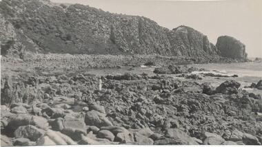
One of a collection of over 400 photographs in an album commenced in 1960 and presented to the Phillip Island & Westernport Historical Society by the Shire of Phillip IslandPhotograph of Rocks and Beach south side of Cape Woolamai.local history, photography, photographs, coastline, rocky beach, reef, cape woolamai, phillip island, reefs, john jenner, bryant west -
Glenelg Shire Council Cultural Collection
Slide - Glass Slide - Glenelg River, n.d
GLASS SLIDE - Glenelg River, Donovans, South Australiaglenelg river, donovans, south australia -
Eltham District Historical Society Inc
Folder, Langden, Mr
Folder of information on Mr Langden, vigneron, South Evelynlangdon