Showing 2559 items
matching aerial
-
 Bendigo Historical Society Inc.
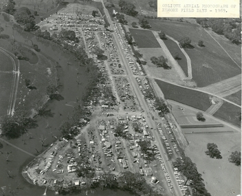
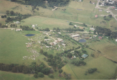
Photograph - ELMORE FIELD DAYS 1969
Aerial photograph of Elmore Field Days 1969. Photo is attached to heavy card backing. Image shows Field Days site with exhibitor stands. Lines of parked vehicles along roadside. Adjacent to the site is an anabranch of the Campaspe River. A sticker on top of photo states ' Oblique Aerial photograph of Elmore Field Days - 1969'event, agriculture, elmore field days, 1969 -
 Bendigo Military Museum
Photograph - 4th Field Survey Squadron – Operation NERVOSE 85 Field Phase Oblique Photos, NT, 1985
This is a set of 20 oblique aerial photographs taken during the field phase of 4th Field Survey Squadron’s Operation NERVOSE 85 project in the Northern Territory in 1985. Operation NERVOSE 85 was mounted by 4 Fd Svy Sqn in the EAST ARNHEM, VICTORIA RIVER DOWNS AND DALY WATERS areas of the Northern Territory from 26 May to 18 Sep 85. The aim of Operation NERVOSE 85 was to finalise the horizontal and vertical control for mapping at a scale of 1:50,000, to field check 40x 1:50,000 preliminary maps and to obtain mapping photography in support of the RAAF TINDAL redevelopment project. *Note –These photos were most likely taken in 1985, contrary to the ‘1987’ date annotated on the negative sleeves. The Op NERVOSE 85 Project Report available on RASVY’s web site lists a nominal roll of personnel. Photos of 4 Fd Svy Sqn taken in 1985 and 1987 provide names of posted personnel. Several personnel identified in these photos were posted to 4 Fd Svy Sqn in 1985, not in 1987. See items 6504.13P, 6505.28P and 6506.16P for more photos taken prior to and during Operation NERVOSE 1985. This is a set of 20 oblique aerial photographs taken during the field phase of 4th Field Survey Squadron’s Operation NERVOSE 85 project in the Northern Territory in 1985. The colour photographs on 35mm negative film and are part of the Army Survey Regiment’s Collection. The photographs were scanned at 96 dpi. .1) to .20) - Photo, colour, 1985. Unknown locations..1P to .20P – There are no personnel identified. ‘1987 OP NERVOSE VICTORIA RIVER DOWNS AND DALY WATERS.’ annotated on negative sleeve.royal australian survey corps, rasvy, 4 fd svy sqn, op nervose 85 -
 National Vietnam Veterans Museum (NVVM)
Photograph - Photograph, Suoi Nghe, 7RAR
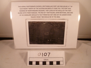
A reprinted black and white Photograph of an area with a small rectangle area in the middle and the road goes down from below middle left side to near bottom on the right side. Above the photograph reads: This aerial photograph shows a rectangular fort like enclosure at "Ap Suoi Nghe" North of the Australian Base at Vung Tau. the fort was manned by Montagnard soldiers who lived with their families within the walls of the village. The RSO of 7 Battalion, John Methven, and one of his signalers would fly out from Nui Dat and act as liaison when troops from 7 BN would be in the area.This aerial photograph shows a rectangular fort like enclosure at "Ap Suoi Nighe" north of Australian base at Vung Tau. The fort was manned by montangard soldiers. They lived in the walls of the fort along with their families. The RSO of 7 Battalion, John Methven and one of his signalers would fly out from Nui Dat and act as liaison when troops from 7 BN woul be in the area.7 rar, 7 battalion map, john methven, montagnard, suoi nghe, signals -
 City of Ballarat Libraries
Photograph - Card Box Photographs, Queen Elizabeth Geriatric Centre, Ballarat circa 1945
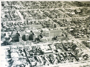
Aerial view of the QEGC on Ascot Street.queen elizabeth geriatric centre, qegc, ballarat, ascot street, building, public building, medical -
 Eltham District Historical Society Inc
Photograph - Aerial Photograph, Intersection of Main Road and Bridge Street, c.1995
View of Main Road from Henry Street to Brougham Street across to the Diamond Creek showing the Eltham Shire Offices (demolished 1996), the Eltham Library (opened 1994)aerial photo, alistair knox park, bridge street, brougham street, central park, diamond creek (creek), eltham, eltham community centre, eltham courthouse, eltham justice precinct, eltham living and learning, franklin street, henry street, local history centre, main road -
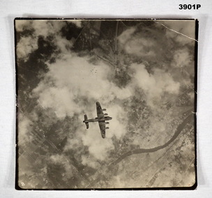 Bendigo Military Museum
Memorabilia - PHOTOGRAPH, c.WWII
British Lancaster Bomber releasing bombs over a target. EAW is marked on the side of the bomber . Item re Frederick Gardner DAVEY DFC No 410533 RAAF. Refer Reg No 3536P for his service details.Black / white aerial photo of a British aircraft flying over land partly covered by cloud. A stick of bombs released by the aircraft is visible.On back - Handwritten in blue ink: Stick of bombs going down Stamped: Crown copyright reservedphotography, lancaster, raaf -
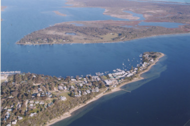
 Phillip Island and District Historical Society Inc.
Photograph, 26/12/1920
One of a collection of over 400 photographs in an album commenced in 1960 and presented to the Phillip Island & Westernport Historical Society by the Shire of Phillip IslandPhotograph of Herald Newspaper clipping 26/12/1920, showing part of a photograph of the Bi Plane winner of "The Herald" Cup in Aerial Derby.local history, photography, herald newspaper clipping, black & white photograph, herald newspaper, herald cup, aerial derby, bi planes, john jenner, bryant west -
 Glenelg Shire Council Cultural Collection
Photograph - Photograph - Aerial view of the Port of Portland from the south-west, c. 1967
Port of Portland Authority archives.Front: (no inscriptions) Back: Area available for silo extension and storageport of portland archives -
Glenelg Shire Council Cultural Collection
Photograph - Photograph - silos, n.d
Port of Portland Authority Archivesport of portland archives, port of portland, silos -
Glenelg Shire Council Cultural Collection
Photograph - Photograph - Thomas Borthwick & Sons, n.d
Port of Portland Authority ArchivesBack: 40 7 3 in pencilport of portland archives, thomas borthwick and sons, abattoir -
Glenelg Shire Council Cultural Collection
Photograph - Photograph - Portland Harbour, n.d
Port of Portland Authority Archivesport of portland archives, portland harbour -
4th/19th Prince of Wales's Light Horse Regiment Unit History Room
Radio Set C11/R210, abt 1950's
Used mid 1950's to mid 1970'sEquipment used by the Regiment as rear linkA HF radio installation consisting of four main units: C11 Transmitter, R210 Receiver, Power Supply Unit and, Aerial Tuning Unit C11 - No 155, R210 - No 5092, PSU - No 287/366, ATU- No2118/367radio c11/r210 -
Glenelg Shire Council Cultural Collection
Photograph - Photograph - aerial view of Portland, n.d
Port of Portland Authority ArchivesBack: Harbour - pencilport of portland archives, aerial photography, portland harbour, henty park, canal -
Glenelg Shire Council Cultural Collection
Photograph - Photograph - Portland Harbour, n.d
Port of Portland Authority ArchivesBack: harb017port of portland archives, portland harbour, bathing boxes, henty beach -
Glenelg Shire Council Cultural Collection
Photograph - Photograph - aerial view of Portland Harbour, n.d
Port of Portland AuthorityBack: harb020- pencilport of portland archives, aerial photography, portland harbour, k s anderson wharf -
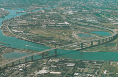 Port Melbourne Historical & Preservation Society
Postcard - Aerial view of West Gate Bridge, c. 1985
Colour postcard showing a photographed aerial view of the West Gate Bridge. Also visible is the aircraft factory and the industrial area of Fishermens Bendwest gate bridge, engineering - bridges, built environment - industrial, fishermans bend -
Port Melbourne Historical & Preservation Society
Photograph - Air Force Band and personnel, Princes Pier, Port Melbourne, Royal Australian Air Force (RAAF), 1924
Air Force aerial photos of the visit of HMS Hood and HMS Repulse 1924 03 - Air Force band and personnel on Princes Pierpiers and wharves - princes pier, transport - shipping, armed services - navy, hms hood, hms repulse, ss james patterson -
Port Melbourne Historical & Preservation Society
Photograph - Aerial view of Port Melbourne, 1931
Section of aerial photograph of Port Melbourne c1931 (refer item 574), covering Beach almost to Bridge Street and Lagoon to Bay Streetsandridge lagoon, built environment -
Port Melbourne Historical & Preservation Society
Photograph - SS Nairana, C.1951
The SS Nairana was launched 1915 by William Denny & Brothers in Dumbarton Scotland the 3,402 ton steamer was requisitioned by the Royal Navy and served during WW1. In 1922 she was transferred to Tasmanian Steamers and, apart from again being requisitioned for war service in WW2, was used as a Bass Strait ferry until 1948. The Nairana was blown ashore onto Port Melbourne beach during a severe gale on 19 February 1951. After salvage what remained of the wreck was blown up in 1954. B & W aerial photograph of SS Nairana and Port Melbourne foreshore. Ship's outline can be seen on far right side of photograp.ss nairana, transport - shipping -
Port Melbourne Historical & Preservation Society
Photograph - Aerial view of Williamstown piers and Alfred Graving Dock, Port of Melbourne Authority, c. 1925
Black and white aerial photo of Williamstown Piers and Alfred Graving Dock, with caption, both pasted onto paper with chequered computer bordertransport - shipping, piers and wharves, williamstown, alfred graving dock -
Tatura Irrigation & Wartime Camps Museum
Photograph - copy, 1988
Tatura Internment camp built during WW2. For German POW's. Photographs taken at exhibition of camp memorabilia displayed at Templers Home for Aged, Bayswater, Victoria, in 1981Colour photograph of a painting by Luise Katz. Aerial view of Tatura Internment camp showing areas A, B, C and D. Negative no. 16.german pow's, tatura, internment camps, ww2 -
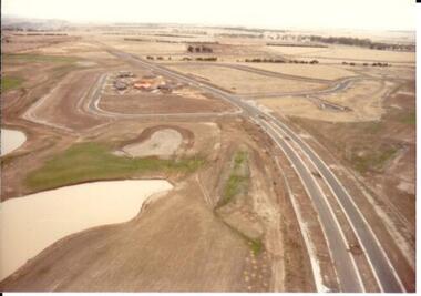 Hume City Civic Collection
Photograph, c 1978
On 4th August 1978 the construction of the Goonawarra Estate commenced. The estate was formerly known as the Goonawarra Farm and overlooked the Sunbury Township and the Jacksons Creek Valley. Plans for the development included a golf course, houses and community and recreational facilities. The golf course opened in 1980 and the housing construction continued throughout the last two decades of the twentieth century and into the twenty first century.A coloured aerial photograph of a display village area under construction. Two lakes are on the LHS of the photograph and Francis Boulevard is in the foreground and the middle distance.goonawarra golf club, goonawarra farm, goonawarra housing estate, housing developments, sharkey, robert b., kilkenny homes, australian ideas homes pty.ltd., glamor homes, craftsmen homes., villa bella homes, george evans collection -
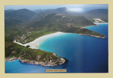 South Gippsland Shire Council
Photograph, Mounted, Tidal River Wilson's Promontory, 2003
Aerial colour photograph titled "Tidal River Wilson's Promontory. Laminated and block mounted on foamcore board. Text panel lower edge. -
Canterbury History Group
Photograph - Aerial view of quarry, 1963
Melbourne 1963 ProjectBack and white aerial photograph taken in 1963 of Canterbury / Balwyn brickworks area, showing the quarry behind Rochester and Mont Albert Roadscanterbury, rochester road, mont albert road, quarries, brickworks, john august reserve -
 Lakes Entrance Historical Society
Photograph - Metung, 2005 c
Colour aerial photograph of Shaving Point Gippsland Lakes looking eastward over Mosquito Point Bancroft Bay in between Metung Victoriaaerial photograph, settlement, waterways, metung -
 Lakes Entrance Historical Society
Photograph - Lakes Entrance, 1993c
Red brick house on right O'DonnellsColour aerial photograph of Blair Road showing first few dwellings of housing estate Tarra Landing in background Lakes Entrance Victoriaaerial photograph, township -
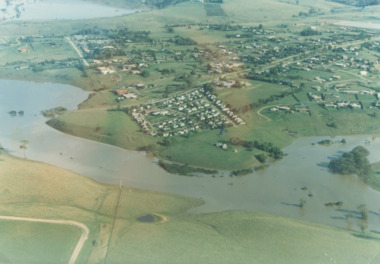 Lakes Entrance Historical Society
Photograph - Mitchell River in flood Bairnsdale Victoria, 1/04/1990 12:00:00 AM
There was a deluge overnight in headwaters of Mitchell and Avon Rivers so the rivers rose overnight and flooded low lying areasColour aerial photograph of Mitchell River in flood showing Clifton Waters Village in centre and township of Wy Yung near Bairnsdale Victoriarivers, floods -
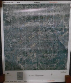 Bendigo Historical Society Inc.
Map - BENDIGO AERIAL MAP 2007
Aerial map of Bendigo 2007 printed on vinyl. Written on bottom of map ' Australian Government Department of Defence photomap Bendigo Australia WGS84.aerial photo, bendigo map -
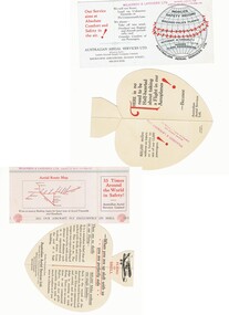 Bendigo Historical Society Inc.
Document - BASIL WATSON COLLECTION: PUBLICITY CARDS FOR AUSTRALIAN AERIAL SERVICES LTD, c. 1930
Two publicity cards for Australian Aerial Services Ltd a. heart-shaped fold-out card highlighting the safety record of Australian Aerial Services Ltd. 'Flying with Shell' pop-out on card with image of bi-plane 'There is no need to be Half-hearted about taking a Flight in our Aeroplanes!When you are up aloft with us you are perfectly safe'; b. rectangular card highlighting safety record of AAS Ltd with aerial route map on reverse. Inside card: We will not stunt; Land on Unknown Grounds; or Fly unnecessarily Low. We always - Take off into wind; Overhaul our engines and aircraft periodically; and Consider comfort of our Passengers' Red stamp of 'Wilkinson & Lavender Ltd on back of card - Booking agents for Australian Aerial Services Ltd'business, transport, aviation -
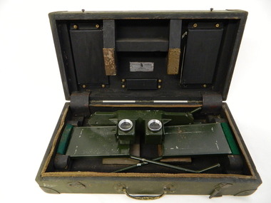 Kiewa Valley Historical Society
Stereoscope
The stereoscope was an interpretation device used to interpret aerial photography and the landscape. It was used by National Parks Victoria located at Mt Beauty to look at aerial photos so that they showed up the relief of the topography and therefore looked 3D.Used by National Parks Victoria staff located at the Mt Beauty office during the 1970's and early 1980's.Dark green wooden box with padded protection around the perimeter and on lid where 2 rectangular pieces of wood touch the stereoscope. The box is fitted with wooden dividers that fit around the stereoscope. The stereoscope is green metal with folding legs and sides attached to allow the stereoscope to sit on a surface. The instrument has 2 round glass ('mirrored viewing lens') cylinders eye distance apart, that allow light in from the side swinging doors. The amount of light is constricted by a rectangular piece of metal at the top of each leg. The box has swing clips used to close it and a metal swing handle all on the front side.The hinges are reinforced (and offer protection) by additional rubber pieces at each end. Inside the box is a brush made of bristle with a wooden handle - used for cleaning.Outside and top of box: written in black: No. 1026. On blue tape beneath: Mirror stereoscope 1026. written in black centre top of box: W10/WKA.0233. On front edge of box written in black: W10/WKA 0233. Inside box lid on silver plaque: Stereoscope Universal/ Made in / Australia / Die Casters Ltd. Victorianational parks victoria. stereoscope. aerial photographs. scientific instrument. mt beauty. 3d