Showing 1479 items matching "carts"
-
 City of Moorabbin Historical Society (Operating the Box Cottage Museum)
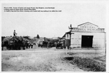
Photograph - Photograph Hay & Corn Store, Before 1910, Smith's Hay & Corn Store, Cnr. Centre and Jasper Roads, Bentleigh, Late 19th to early 20th Century
The first photograph was taken prior to 1910. The location is at the corner of Centre and Jasper Roads, East Brighton, (now known as Bentleigh). It is an early view of John L. and "Minnie" Smith's Hay and Corn Store, situated on the South West corner of those two roads. The first photo was taken prior to the introduction of electricity in the area. A gas lamp and horse "hitching post" can be seen "in shot". There are several loaded wagons waiting in line to have their hay milled to chaff. Farmers came from places as distant as Carrum to have their loads of hay milled into chaff. John Smith was born in 1860 in Point Nepean Road, Brighton, and Minnie was born in Patterson Road, Moorabbin, in a wattle and daub cottage with earthen floor and butter muslin over the windows. The couple married in 1884, Minnie was a devout Methodist and the family became very involved in the development of the local Methodist church. The couple had four children and during the 1890s Depression their first child died, they lost all their possessions, and John's family struggled to survive. Finally in the late 1890s JL Smith was able to rent a shed from Mr Henry Box on the corner of Centre and Jasper Roads, and he later purchased that property. With the gradual improvement in the economy, and the development of the successful market gardening industry in the Shire of Moorabbin, JL Smith's produce store became quite prosperous. Over some years the little "shed" developed into a thriving Hay and Corn Store. JL Smith went on to become Moorabbin Shire President in 1914. He and his wife were active in assisting soldiers returning injured from the 1st WW, in the local Methodist Church and other early community projects. Smith was a typical example of the majority of the early settlers in the Shire of Moorabbin, being god-fearing and devoted to the idea of service to the community. The photographs demonstrate the primitive conditions and early development of what is now a bustling and well-recognised area of Bentleigh, (known as east Brighton before 1907). The photo shows a gas lamp in use before the introduction of electricity in 1916. The Smith's story is representative of the many early pioneering traders, who elected to "set up shop", who suffered the adversity of the 1890s depression, but who survived and made their living in the largely undeveloped area of East Brighton ( now Bentleigh) district. Two black and white early photographs both of the same location. The photos are of the corner of Centre and Jasper Roads, Bentleigh. (Prior to 1907 this area was known as East Brighton.) Both photos show J.L Smith's General Merchant Produce store. "Steam Chaff Cutting and Corn Crushing Mills" and the surrounding area at differing stages. In the first photo taken prior to 1910, we can see there are several horse-drawn carts loaded with hay waiting to be milled, a gas lamp and a horse "hitching post". The store is just a single unadorned, shed. The later, second photo of the same area, shows improvements and the further development of that site. On the back of the photo "Hay and Corn Store -/ not later than 1910."/"Photographer /Victor C Smith,/ Phone Number XL1472"/hitching post, methodist church, smith minnie, moorabbin shire president, gas lamp, east brighton district, 1890s depression, wattle and daub cottage, centre road, jasper road, box henry, smith john l -
 Bendigo Historical Society Inc.
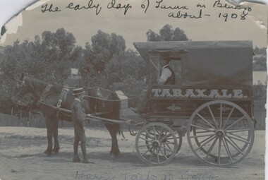
Photograph - HORSE DRAWN VEHICLE WITH MAN AND BOY, c.1908
Black and white photograph of four wheeled horse drawn vehicle. Adult male driver, boy standing near horse. Inscriptions: on front - hand written across top 'The early days of Tarax in Bendigo about 1908' Hand written across bottom 'Harry Laity (may be Tait) in wagon'. Painted on wagon 'Taraxale'. History of object: James Lerk 2000 - 'The original DELIVERY CART FOR George Pethard's soft drink firm which he commenced in Panton Street, Golden Square. The 'Taraxale' wagon belonged to Harry Laity (or Tait). Photographed c.1908. Photographed for Bendigo Advertiser 4.7.2000organization, business, taraxale -
 Bendigo Historical Society Inc.
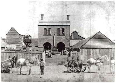
Photograph - NORFOLK BREWERY, 1961
black and white photo: rear of Norfok Brewery, mid centre brick building, 2 arched doorways on ground floor, 2 double arched windows top floor, 1 chimney at each end of roof. Lane fence at front. Dove cote, 2 buildings at right. Tall timber building at left centre., Tall timber at left centre. ' Batchelder photographer Pall Mall' van and horse left front. Horse and dray with 3 barrels right front. 3 men handling barrels. Slab fence, slab buildings at right. Written on side of horse cart: Sayer & Co.batchelderbuildings, commercial, produce store -
 Bendigo Historical Society Inc.
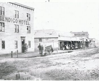
Photograph - BRIDGE STREET: SANDHURST, 1861
Copy of black and white photo: Bridge Street streetscape near site of the present Chinese Museum. Showing Bendigo Hotel at left,. 'Crossingham & Goodman, Saddlers ' ' J. Holdsworth', 'Glass and Chines Warehouse'. 'Batchelder, Photographer, Pall Mall' handcart in foreground. 3 storey weatherboard building with 3 males at door, 2 males and photographers cart in front of fence. Row of single storey buildings with verandahs, some with business signs. 2 storey building at back. Deep gutters with foot bridges over. On back in grey lead '12' Note: Batchelder and his assistant are standing at the hardcart' ( James Lerk 22.9.2000 }Batchelder, Pall Mallplace, streetscape, bridge street -
 Bendigo Historical Society Inc.
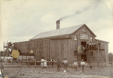
Photograph - BENDIGO BONE MILLS, c1880
Sepia photograph on grey mount of P Rohs Bone Mills, artificial manures, flock mills. Timber building, with large brick chimney stack. Dray loaded with bags of manure pulled by white horse. Female and male figures on platform in front of building. Two children and group of five males and one female on ground. Inscriptions: in image - 'P Rohs, Bendigo Bone Mills, Artificial manures, flock mills'. On cart in image - 'Bendigo Bone Mills', On front TR corner 'MP115'. On back - 'Peter Rohs Fertilizer Factory, Rohs Road, Bendigo c1880'. Handwritten on back in ball point pen.buildings, commercial, p rohs bone mills -
 Bendigo Historical Society Inc.
Document - SEDGWICK INFORMATION
Document, Sedgwick, was known as Upper Emu Creek until 1901. It is located ten miles south of Bendigo in hilly sedimentary and granite country.The first freehold grants were taken up in 1854. In 1861 the Strathfieldsaye Road District was Proclaimed. Five years later it became the Shire of Strayhfieldsaye.Mining west of the Axe Creek commenced in 1863. Agriculture, farmers made modest livings from vineyards, orchards,dairy cattle, eggs and tomatoes. The Osborne family had seventy acres planted to apples. Prior to 1934 Favaloros collected cream from district farms, then fresh milk in cans was carted to Bendigo until 1970.document, sedgwick -
 Southern Sherbrooke Historical Society Inc.
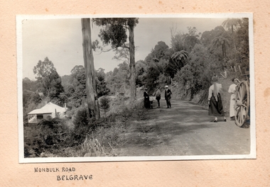
Photograph, Monbulk Road, Belgrave
Groups of people are standing on Monbulk Road, up from Belgrave. In the background are four women abreast walking away. There are two men, a young boy and a woman standing together in the middle ground and two younger women closer to the camera, standing beside a cart (with only a large cartwheel visible). There may be another man speaking to them. There is a path going up the hill to the right, with fence posts on the high side and a closed gate at the top. On the left of the photo there is a house below the road. There are two water tanks which look new. It may be the same house as appears in other photos in this collection. Another building is visible in the distance. -
 Bendigo Historical Society Inc.
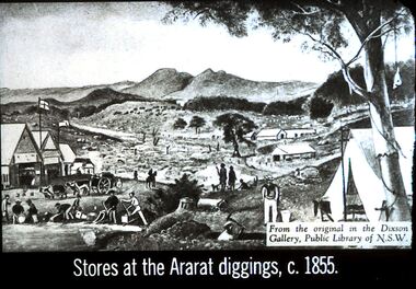
Slide - DIGGERS & MINING. STORES AT THE DIGGINGS, c1855
Diggers & Mining. Stores at the diggings. Stores at the Ararat diggings, c. 1855. From the original in the Dixon Gallery, Public Library of NSW. Slide depicts the scene at the goldfields with the Commissioners huts and in the background there are other buildings. On the Gold field there is a man on a horse, a man with a heavily laden cart being pulled by 4 ox. Some men are working in the gully for gold, panning, using cradle. In the front centre at the bottom is the head and shoulders of a man with an axe digging out his mine. There are also some dogs in the picture and a tent in the front right corner. Markings: 12 994.LIF. 5. Used as a teaching aid.hanimounteducation, tertiary, goldfields -
 Kew Historical Society Inc
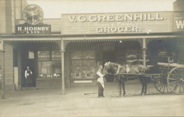
Postcard - V.G. Greenhill's Grocery Store, High Street (Kew), c.1902
R.H. Hornby & Sons, jewellers, and V. Greenhill's Grocery Store were located at 43 1/2 and 45 High Street (formerly Bulleen Road) respectively, in the block of shops between Brougham Street and Walpole Street. The grocery first appears at this location in 1893 but only in 1902 is the jeweller's shop located next door. (Sands & McDougall Directories). The Greenhill family were significant pioneers of Kew in the nineteenth century and their members participated in many civic, community and sporting organisations.Original sepia, real photo postcard of two shops in High Street, Kew, circa 1902. The businesses were R. Hornby, jewellers and opticians, and V.G. Greenhill, grocer. The proprietor of the jeweller's shop stands in his doorway while a member of staff of Greenhill's is standing on the road with a horse and cart owned by the business. The signage on the grocery shop identifies the kind of business offered - Choice fruits & confectionery / Dairy Produce a specialty. On the windows from left to right are advertisements for Fry's Chocolate, Fry's Pure Cocoa, and Cadbury's Cocoa and Cadbury's Chocolate. Above the doorway is a pane of etched glass reading GREENHILL 45.Unmarked postcard layout on reversev greenhill, grocery stores -- kew (vic.), jewellers -- kew (vic), high street -- kew (vic.), businesses -- kew (vic), hornby family, greenhill family -
 Kew Historical Society Inc
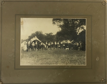
Photograph, Edwin Anderson, 1st Kew, Bulleen, 1924, 1924
A group of Scouts lining up for a meal. It would have been cooked by the ‘duty patrol’, with each patrol of Scouts taking turns at being the ‘duty patrol’. During this period, the local Scouts were recorded as regularly camping at Bulleen, on the property of a friendly farmer. As well as short overnight camps, the Scout Troop would have had a longer 8 to 10 day camp over the Christmas holidays every year. In the 1920s the Scouts often transported their camping gear by means of a hand-pulled ‘trek-cart’, which is no doubt why camping just down the road at Bulleen would have had appeal! On mounting board: 1st Kew Bulleeen 1924. On reverse: photographer's stampscouts - kew, 1st kew scouts, scout camp 1920s, bulleen -
 Linton and District Historical Society Inc
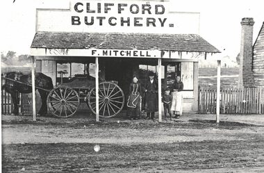
Photograph, Clifford Butchery near Linton, F. Mitchell Proprietor
The people in the photograph are not identified, but the man is believed to be Frederick Mitchell, who farmed at Argyle (on road now known as Mitchells Road). The farm was known as Clifford Farm. Frederick Mitchell ran a butcher's shop there from the late 1880s to the mid 1890s. Frederick Mitchell's first wife was Jane McDonagh, and his second wife was Jane's sister Isobel McDonagh.Enlarged black and white copy of original photograph. Photograph shows a shop building with a verandah, which has a shingled roof in fairly poor condition. A sign "CLIFFORD BUTCHERY" is over the shop building, and the name "F. MITCHELL" on the fascia board of the verandah. Three adults and a child are standing outside the shop under the verandah - a man wearing a coat and hat and a long apron, a woman wearing a dark dress and an apron which has a white trim, a young boy, and an older girl who is wearing a dark top and a light-coloured apron. A horse and cart are also under the verandah - horse only partly visible.mitchell family, frederick mitchell, clifford butchery, clifford farm -
 Bendigo Historical Society Inc.
Photograph - LONG GULLY HISTORY GROUP COLLECTION: STREETSCAPE
BHS CollectionBlack and white photo of a streetscape with various buildings, earth street and wood rail fencing. At the right edge is the Commercial Hotel. In the centre is a building with a veranda with P. Pentreath printed above the veranda. At the edge of the veranda is a sign with Post Office on it. Next is a Dr J W Sibley, Physician next to a bakery. On the left of the photo is a slab building with the windows propped open and a cart in the front of it. A two rail fence is in the front of the hut. There are other buildings in the background including what looks like a church behind the slab hut. The photocopy for this item is not available at this time, 23 Jan. 2020. The original photo for this item is at the bottom of box 621bendigo, history, long gully history group, the long gully history group - streetscape, p pentreath, commercial hotel, dr j w sibley? -
 The Beechworth Burke Museum
Photograph, Late 1900s
This photograph dating to the late 1900s depicts the entrance to a reef mine the in Beechworth division. The image depicts two men outside the entrance, which is covered by a hut, where one is standing near a mine cart. The mine car was used to haul soil from the mine. The Beewchworth divison consisted of 5 locations: Beechworth, Stanley, El Dorado, Hurdle Flat and Stony Creek. These locations were set up due to speculative fever that more gold could be found. In places such as El Dorado, Beechworth and Stanley there was profit, however Hurdle Flat and Stonry Creek, gold could not be found in the quantities that was required. By 1880 the Beechworth division was in depression due to the reserves being used up. However, in spite of the depression mining was continued until the late 20th Century.The search for gold is ingrained into the history of Victoria and therefore, images like this one which portray an open cut sluicing site can reveal important information for society and technology for the date when the photograph was taken. This image is of important historical significance for its ability to convey information about reef mining in the late 1900s. It also shows a location where reef mining was undertook which provides insight into the impact of reef mining on the environment at a time when it was done. This image is important for current research into the history of Beechworth , a town in Victoria's north-east. Therefore, this image has the capacity to be beneficial for research into society and the motivations of those living and working in this region during this period and therefore, has social significance. The Beechworth Burke Museum has additional images relating to reef mining and Beechworth which can be analysed and studied alongside images like this one.Sepia coloured retangular photograph printed on newspaper.Reverse: 7813beechworth, beechworth division, mining, reef mining, gold, gold mining, 1990 -
 Warrnambool and District Historical Society Inc.
Financial record - Ledger: Warrnambool Water works Trust, Circa 1900
This ledger contains entries which relate to waterworks and associated expenses: construction, pumping schemes, water from stand pipes, meter rent arrears, interest payments, pumping scheme. Early residents in Warrnambool relied on tanks and wells for their water supply and in 1880 the first water supply scheme was implemented from a well on Cannon Hill. Using a windmill the water was pumped up and stored in a small reservoir nearby then piped to the corner of Timor and Liebig Streets where a stand pipe allowed the filling of water carts. Similar supplies were also installed at Albert Park, the Botanic Gardens and the Cattle markets and from 1893 to 1939 water was drawn from the Merri River. Drainage works commenced with the building of the Japan Street tunnel in 1856. The Warrnambool Waterworks Trust was the body responsible for administering these works.The supply and storage of fresh water and drainage of the area was an important factor in the development and sustainability of the town. This ledger provides an insight into the daily operations of this organisation. Large suede covered journal. Tan in colour with pink, green and white on edge of pages. Faded black stylised border around front cover. Inside front covers are patterned in green and tan. Printed sheet with Warrnambool waterworks Trust is pasted inside front cover. Warrnambool Waterworks Trust stamp on sheet inside front cover.warrnambool water works, warrnambool water supply 1900, warrnambool water works ledger 1900, warrnambool waterworks trust -
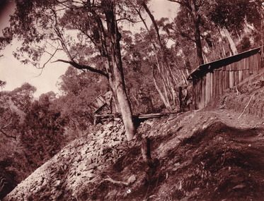
 Eltham District Historical Society Inc
Photograph, Fay Bridge, EDHS Heritage Excursion, Culla Hill, Sweeneys Lane, Eltham, 7 September 2019
September Excursion - Culla Hill Walk Pioneer Eltham farmer Thomas Sweeney (1803 - 1867) named his house, “Culla Hill” after the area in Ireland that he came from. His house, now called “Sweeneys”, remains on a ridge line overlooking the Yarra River. It is recorded that Thomas Sweeney did well out of carting potatoes and other supplies to the various gold fields such as Bendigo, McIvor (Heathcote), Mount Alexander and Beechworth. Culla Hill is now the name of the road providing access to subdivided lots of the former Sweeney property. The Culla Hill walk will start at the corner of Kent Hughes and Lavender Park Roads, Eltham (Melway ref. 22 A9) at 2.00pm on Saturday 7th September. - EDHS Newsletter No. 247 August 20192019-09-07, activities, culla hill, eltham, eltham district historical society, fay bridge collection, heritage excursion, sweeneys lane -
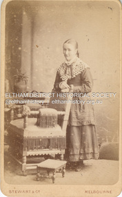 Eltham District Historical Society Inc
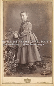
Photograph, Stewart & Co, Possibly Caroline Shillinglaw, c.1877
Caroline Shillinglaw was born at Plenty, October 6, 1863. She died at the Shillinglaw family cottage 'Wattle Brae' in Eltham April 11, 1947. Caroline never married and was the youngest of Phillip Shillinglaw's siblings. Stewart & Co operated from 217-219 Bourke St., East from 1877 to 1889 CARTE-DE-VISITE (cdv) 1857-1890 Cartes-de-visite (cdv's) are the most common form of photograph from the nineteenth century, generally measuring two and a half inches by four and an eighth inches (6.3 x 10.5 cm) when mounted, sepia toned, mounted on a card which was generally printed with the photographer's name and address on the back or beneath the portrait. - Frost, Lenore; Dating Family Photos 1850-1920; Valiant Press Pty. Ltd., Berwick, Victoria 1991marg ball collection, shillinglaw family photo album 1, 1877, 1877-1889, caroline shillinglaw (1863-1947), unknown, stewart & co photographers 217 & 219 bourke st east melbourne -
 Eltham District Historical Society Inc
Photograph, Stewart & Co, Possibly Caroline Shillinglaw, c.1875
Caroline Shillinglaw was born at Plenty, October 6, 1863. She died at the Shillinglaw family cottage 'Wattle Brae' in Eltham April 11, 1947. Caroline never married and was the youngest of Phillip Shillinglaw's siblings. Stewart & Co operated from 217 Bourke St., East from 1871 to 1876 CARTE-DE-VISITE (cdv) 1857-1890 Cartes-de-visite (cdv's) are the most common form of photograph from the nineteenth century, generally measuring two and a half inches by four and an eighth inches (6.3 x 10.5 cm) when mounted, sepia toned, mounted on a card which was generally printed with the photographer's name and address on the back or beneath the portrait. - Frost, Lenore; Dating Family Photos 1850-1920; Valiant Press Pty. Ltd., Berwick, Victoria 1991marg ball collection, shillinglaw family photo album 1, caroline shillinglaw (1863-1947), 1871-1876, 1875, stewart & co photographers 217 bourke st east melbourne, unknown -
 Eltham District Historical Society Inc
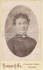
Photograph, Yeoman and Co, Possibly Margaret Shillinglaw, c.1887
Margaret Shillinglaw was William and Jean Shillinglaw's ninth child. She was born at Northcote March 3, 1856 and died at North Fitzroy September 7, 1933. She never married. Photographers Yeoman & Co. operated from 47 Chapel St., Prahran from 1883 to c.1891. CARTE-DE-VISITE (cdv) 1857-1890 Cartes-de-visite (cdv's) are the most common form of photograph from the nineteenth century, generally measuring two and a half inches by four and an eighth inches (6.3 x 10.5 cm) when mounted, sepia toned, mounted on a card which was generally printed with the photographer's name and address on the back or beneath the portrait. - Frost, Lenore; Dating Family Photos 1850-1920; Valiant Press Pty. Ltd., Berwick, Victoria 1991marg ball collection, shillinglaw family photo album 1, 1883-1891, 1887, margaret shillinglaw (1856-1933), unknown, yeoman & co photographer 47 chapel st prahran -
 Eltham District Historical Society Inc
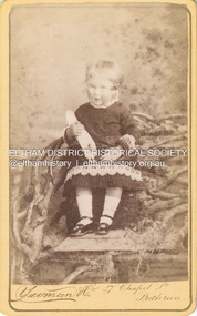
Photograph, Yeoman and Co, Possibly Florence May Aldous, first born child of Sarah and Charles Aldous, c.1885
The girl appears to be about 2 years of age. If she is Sarah and Charles's first child, Florence May Aldous then the date would be c.1885 A duplicate photo is in Album 2 (05664) Photographers Yeoman & Co. operated from 47 Chapel St., Prahran from 1883 to c.1891. CARTE-DE-VISITE (cdv) 1857-1890 Cartes-de-visite (cdv's) are the most common form of photograph from the nineteenth century, generally measuring two and a half inches by four and an eighth inches (6.3 x 10.5 cm) when mounted, sepia toned, mounted on a card which was generally printed with the photographer's name and address on the back or beneath the portrait. - Frost, Lenore; Dating Family Photos 1850-1920; Valiant Press Pty. Ltd., Berwick, Victoria 1991marg ball collection, shillinglaw family photo album 1, 1883-1889, 1885, florence may aldous, yeoman & co photographer 47 chapel st prahran -
 Eltham District Historical Society Inc
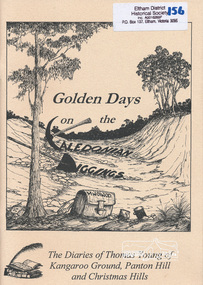
Book, Golden Days on the Caledonian Diggings: the diaries of Thomas Young of Kangaroo Ground, Panton Hill and Christmas Hills, compiled by Mick Woiwod, 2005
The original diaries, (1859-1866,1895-1900) of Thomas Young discovered by a Young descendant have been transcribed with the author adding his own research and historical photographs. The diary sheds light on the lives of prospectors who worked the Caledonian goldfields in the 1860s, including St Andrews and Smiths Gully. Thomas Young, migrated from Scotland and moved to the goldfields in 1858. He carted ore by horse and dray from mines around St Andrews to crushers in Panton Hill and Smiths Gully. He later became a baker. He and his wife Bridget had eleven children. He later settled at Christmas Hills establishing the local store and school. See also: "Old Diary Strikes Old" by Natalie Birch, Diamond Valley Leader August 17 2005The diary provides a rare first-hand account of life on the Caledonian goldfields.v. : ill. 69 p 30 cm[written inside front cover] To my very good friend Harry Gilham - Mick Woiwod 25th August 2005thomas young, caledonian gold fields, kangaroo ground, christmas hills, panton hill, smiths gully, st andrews, diary, gold mining -
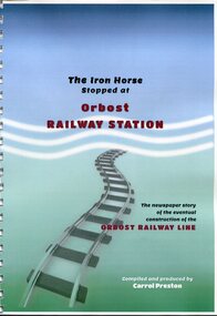 Orbost & District Historical Society
Book, The Iron Horse Stopped at Orbost Railway Station, 2019
Carrol Preston has used newspaper references from 1877 through to 1917, to document the history of the Orbost - Bairnsdael railway line.. It starts with the lobbying and jockeying, and moves through to the opening in 1916. The title is a reference to plans to further extend the railway beyond Orbost - but "The Iron Horse stopped at Orbost Railway Station". Most articles are from the Snowy River Mail and Bairnsdale Advertiser. All newspaper articles are dated and sourced. About 1912 work began at Newmerella on clearing the track for the railway line from Bairnsdale to Orbost. A canvas town sprang up on the higher land adjacent to the river flats. Local farmers supplied meat, milk and fresh produce to the camp, as well as gaining employment carting and labouring. The line opened in 1916, the Orbost railway station being built on the Newmerella side of the river.This item is associated with the history of the Orbost-Bairnsdale railway line and therefore reflects the role that the rail line played in the social and economic history of Orbost. On April 10 1916, the first scheduled train service left Orbost for Bairnsdale. The Bairnsdale-Orbost railway was opened to serve the agricultural and timber industries. This book has been compiled by a local historian. A spiral bound book titled, "The Iron Horse Stopped at Orbost Railway Station". The cover is blue / green with the title in black and red print. Underneath is a railway track leading to the bottom of the page. The book is 110 pages, A4 size and contains maps and photos. in black print on cover - "The Iron Horse Stopped at Orbost Railway Station ; The newspaper story of the eventual construction of the ORBOST RAILWAY LINE (in red print); Compiled and produced by CARROL PRESTON (in white print)railway-transport orbost-bairnsdale-railway east-gippsland-railway -
 Glen Eira Historical Society
Document - Animals
This file contains 2 items: 1/A black, white and green brochure titled ‘Leash Free Parks and Reserves’ concerning leashing regulations, conditions for non-leashing, summaries of legislation and penalties for owners of dogs, written by the City of Glen Eira. It includes six illustrations and a map of Glen Eira which labels all leash free parks as well as a depiction of all the train stations in the area. 2/A collection of 37 black and white photographs which have all appeared in Caulfield Contact at some time. These include photographs of the ‘Caulfield Veterinary Clinic, North Road Ormond dated 1982, Animal Control officer Reg Dixon dated 1982, draught horses pulling a horse drawn cart dated 1988 and general animals. Photographs unknown.allnutt park, murrumbeena park, veterinary clinics, professionals, veterinarians, kirschner jane s., north rd. ormond, dixon reg, animal control officer, horses, racehorses, racecourses, draught horses, bailey reserve, sporting grounds, bentleigh/hodgson reserve, boyd park, neerim road, caulfield park, caulfield race course, duncan mackinnon park, ee gunn reserve, glen huntly park, joyce park, king george v1 memorial reserve, lords park, marara road, marlborough street reserve, moorleigh, victory park, princes park, packer park, animal enclosures, domestic animals, dogs, horse drawn vehicles, cattle, birds, animals, trains, caulfield contact -
 Flagstaff Hill Maritime Museum and Village
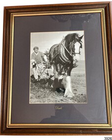
Photograph - Horse and plough, Duke, 20th century
This photograph shows the relationship between the farmer and his working animal, which is a close one. Farmers in years gone by depended on reliable and strong animals to allow them to work their land efficiently. The close relationship is indicated by the photograph's title, the name of the horse 'Duke'. The horse in this photograph is a Clydesdale cross named "Duke" that pulled a market wagon around Flagstaff Hill from the mid-1980's to the early-1990's, providing rides for visiting children and carting goods and equipment around the Village. Duke is pictured with his owner Pat McGowan. Duke passed away in August 1992. In October 1992 funds were raised by the community to purchase another Clydesdale named Duke began working at Flagstaff Hill under Pat McGowan's care.This photograph of man, horse and plough shows the typical farming method used by early settlers in Victoria in the 19th and early 20th century. The photograph is an indication of the respect the farmer had for his working animals.Photograph, black and white, behind glass in timber frame with gilt inner border. Subject is working horse pulling a wooden plough, guided by a man. There is turned soil behind the horse. The name "Duke" is in gold paint script below the photograph.Script "Duke"flagstaff hill, warrnambool, maritime village, maritime museum, shipwreck coast, great ocean road, farm animal, horse and plough, hand plough, horse drawn plough, working horse, duke, duke the horse, early farming, early settler, flagstaff hill maritime museum and village, attraction, clydesdale cross, clydesdale, rides, market wagon, pat, pat mcgowan -
 Otway Districts Historical Society
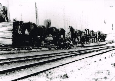
Photograph, Knox Collection, Pettit's Siding: A loader, teamster and their six-horse load, c.1920
Originally known as Smith's Siding, in November 1914 the siding was renamed "Pettits" following the sale of a nearby mill to the north. The sawn timber was initially carted out by bullock wagon but the mud and slush caused such difficulties that Pettits caused a thirty chain incline to be built from the mill to a tramway. The tramway connected the mill to the railway until 1924. An annual average of 2,450 tonnes of timber was despatched from the siding. No provision was made for passenger traffic. After ten years Pettit Brothers had cut out the area and moved on, abandoning the siding which was put out of commission on 23 September 1924. However, local residents, not wishing to suffer the loss of railway facilities, managed to have the siding reopened in February 1925 for goods and passengers. It was lightly patronised until all traffic ceased in 1936. B/W. Sam Knox, timber loader and tallyman, and George Pritchard, a teamster, resting at Pettit's Siding after delivering a six-horse-drawn load of timber to the Siding. Stacks of wood awaiting transport by rail are in the background.pettits siding; wyelangta; railways; smith's siding; sam knox; george pritchard; -
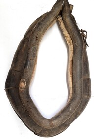 Wodonga & District Historical Society Inc
Functional object - Leather Horse Collar
This horse collar was made and used by the family of Michael Conway who established a dairy farm of 35 acres in Wodonga in 1940. He and his wife Catherine nee Carroll settled there and raised 5 children. Before coming to Wodonga Michael carried on a bakery business at Urana. This collar was used to attach the hames, harness and chains which pulled his bakery cart. In Wodonga Michael Conway built a 2 bail dairy and milked up to 20 cows, separated the cream from the milk by hand and sold it to the local butter factory of Holdensen and Nielsen. In later years only whole milk was sold. The farm was on the outskirts of East Wodonga. Michael Conway died on 6th January 1945. The farm was later sold for residential and industrial development and includes Conway Court.This item has a clear connection to the family of Michael Conway of Wodonga, VictoriaA handmade leather horse collar padded with straw and cloth. It has metal buckles secured by leather straps which are held in place with metal studs.michael conway wodonga, horse harnesses, dairy industry wodonga -
 Rutherglen Historical Society
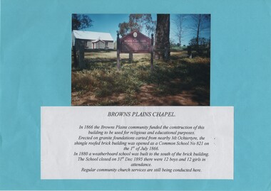
Image, c1985
Colour photograph of a small painted brick building with a story board in front of it. The photograph is mounted on a bright blue sheet of paper, along with a typed caption of the text from the story board.Caption text: "Browns Plains Chapel. In 1866 the Browns Plains community funded the construction of this building to be used for religious and educational purposes. Erected on granite foundations carted from nearby Mt Ochtertyre, the shingle roofed brick building was opened as a Common School No 821 on the 1st of July 1866. In 1880 a weatherboard school was built to the south of the brick building. The School closed on 31st Dec 1895 there were 12 boys and 12 girls in attendance. Regular community church services are still being conducted here."browns plains, churches, schools, common school no 821 -
 Bendigo Historical Society Inc.
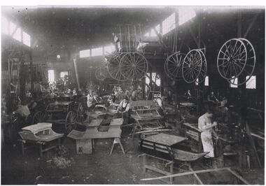
Photograph - COACH BUILDING WORKS
Black and white photograph of a coach building business. Note the number of workers involved in the manufacture of the different styles required by customers. To the right of photo there are a number of workers using machines to manufacture the different body parts that are required. One cart to left of photo appears to be the finished product. Centre top there is a cantilever structure with bodywork stacked on top and a number of wheels, large and small, hanging from the side. There are also a number of wheels hanging from posts of the building framework. Note the differing clothing styles of the workers from shirt, trousers and apron, to hats shirts, waistcoats, trousers. Differing stages of construction have bodies on tables, wooden frameworks, boxes and wooden horses.industries -
 Bendigo Historical Society Inc.
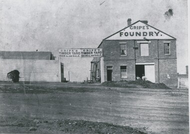
Photograph - GRIPES FOUNDRY, 1861
black and white photo: 2 storey brick building on right. Large central double door ground floor. Door in first storey with beam for raising materials. 2 windows first storey, one on each side of door. Small door and small window on lhs ground floor. Gripes Foundry on gable steps on side to top storey. Entrance gate centre of photo. Double inscription ' Gripes Timber Yard Iron & on sale over gate. Single storey building on left. 2 males in front. Batchelder cart left hand side. In image ' Gripes Foundry' 'Gripes Timber yard, iron & c on sale'batchelderorganization, business, gripes foundry -
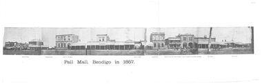 Bendigo Historical Society Inc.
Photograph - BLACK AND WHITE PANORAMIC PHOTOGRAPH OF PALL MALL BENDIGO IN 1857
Black and white fold - out Panoramic Composite photograph of Pall mall Bendigo in 1857 on cream, aged paper showing the Shamrock hotel, Williamson St, Bank of Australasia, site of Arcade, Colonial Bank, Victoria Hotel (now National bank), Hall of Commerce (now Mining Exchange), the Beehive - Francis Brothers Beehive Stores, Pikes Corner, B Morey Saddler, Blythe & Inglis Family Grocer Provisions dealer, Horse Bazaar Cattle sale Yard, Jones & Shiress Chemists, horses and carts- enclosed in envelope addressed to 'Mrs Reube P Lumbe C/- Bethlehem Home for Aged Taylor St Specimen Hillbendigo, streetscape, pall mall, pall mall bendigo in 1857 / shamrock hotel / , colonial bank / victoria hotel /, hall of commerce / mining exchange / the beehive - francis brothers beehive stores/ pikes corner / b morey saddler / , blythe & inglis family grocer provisions dealer / jones & shiress chemists /, horse bazaar cattle sale yard -
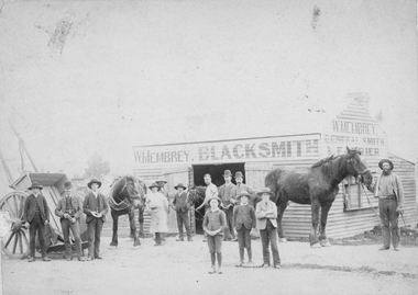 Stawell Historical Society Inc
Photograph, Mr. W. Membrey's Blacksmith Shop in Patrick Street. Stawell c1800's
W. Membrey Blacksmith Shop in Patrick Street beside the sale yards which later became the Technical School Gold Reef Campus. W. Membrey died when young leaving a large family. The business was then rented to Mr. G. Brehaut for 12/6 (twelve shillings six pence) per week. The Membrey family lived in Skene St. Stawell for many years. Notes record that a copy was make by Mark Dadswell, Stawell. Also the notes record in 1996 a copy was made and donated to the Society by Melbourne Museum. 76.1 - V.W. Membrey blacksmith at Marnoo. Donated by Alan Membrey June 2003 Beecroft, NSW.Sepia photograph depicting W. Membrey Black Smith shop. Standing in front of the wooden building are 10 men and 3 young boys. W. Membrey is holding a horse in the door way with 2 other horses either side of the building. A timber cart is to the left of the photograph. W. Membrey Black Smith is written on the front of the building W. Membrey General Smith & Farrier is on the side of the building. There are 3 copies or duplicates of the original photo, one small and 2 large. The second black and white photo (76.1) is of V.W. Membrey Blacksmith & Horseshoer. Three people are standing outside the door to the shed. Written on the back is "Marnoo". Photo donated by Alan Membrey NSW. Patrick Street Stawell Our fathers Black smith shop. he is holding the horse near the door. Wm. E. Membrey. This photo was taken over 100 years ago.stawell