Showing 1562 items matching "diamond creek"
-
 Eltham District Historical Society Inc
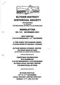
Newsletter, Newsletter, No. 141 November 2001
... : A trip down the Diamond Creek • November Meeting • Christmas...: A trip down the Diamond Creek • November Meeting • Christmas ...Contents: • Next meeting, Slide Show by Russell Yeoman: A trip down the Diamond Creek • November Meeting • Christmas Celebration • The Memorial Tower, Kangaroo Ground – Re-Dedication • Eltham Festival • 2002 Events • ‘Escaping the Big Smoke’ • Kangaroo Ground Happenings by Diana Bassett-Smith • Other Matters The Shire of Eltham Historical Society was formed in October 1967. The first newsletter of the Society was issued May 1978 and has been published continuously ever since on a bi-monthly basis. With the cessation of the Shire of Eltham in late 1994, the Society's name was revised to Eltham District Historical Society and this name first appeared with issue No. 103, July 1995. The collection of the Society's newsletters provides a valuable resource on the history of the Society's activities, office bearers and committee members, guest speakers and subjects of historical interest pertinent to the former Shire of Eltham and the Eltham District.A4 photocopied newsletter distributed to membersnewsletter, eltham district historical society, shire of eltham historical society -
 Eltham District Historical Society Inc
Document - Folder, Sheehan, Frank
... Diamond Creek resident Frank Sheehan became a teacher after...Diamond Creek resident Frank Sheehan became a teacher after ...Diamond Creek resident Frank Sheehan became a teacher after years of agricultural work, later taking up painting. Contents Newspaper article: "The teacher who had cut cane, but never used one", Diamond Valley News, 23 September 1986. Life story of Frank Sheehan,Newspaper clippings, A4 photocopies, etcfrank sheehan, kathleen josephine sheehan nee o'shea, olympic village school heidelberg, wattle glen primary school, research primary school, macleod primary school, lesley sinclair, diamond valley arts society, retarded foundation of victoria, ivanhoe primary school, tony harkin -
 Greensborough Historical Society
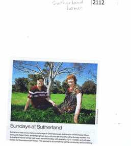
Newspaper clipping, Diamond Valley Leader, Sundays at Sutherland, 2013_
... . It was at 14 Yan Yean Road, Diamond Creek. At the intersection of Yan.... It was at 14 Yan Yean Road, Diamond Creek. At the intersection of Yan ...Desley Elkhom and Ralph Rudd, the owners of Sutherland (once an orphanage) run a Sunday market to raise money for Rotary. Neisha Forbes email 1/4/2017: "In this photograph is of my brother, Ralph Rudd and his partner Desley Elkhom, they were setting up a market at Sutherland Homes site – a community market trying to bring on local produce, and involve the Plenty CFA to raise money for equipment. It ran for about 2 years, but sadly as they did not have indoor cover, it either rained on the Sunday, they had the stalls, but did not get the people, or had the people and no stalls. It stopped about a 18 months ago. It was at 14 Yan Yean Road, Diamond Creek. At the intersection of Yan Yean Road and Diamond Creek Road, the old Sutherland Homes property."News clipping, black text, colour image. Text incomplete. -
 Eltham District Historical Society Inc
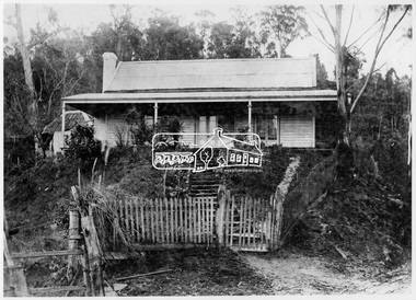
Photograph, Mia Mia, Hurstbridge, 1916
... on Diamond Creek at Hurstbridge. Fred and Catherine Hurst first... on Diamond Creek at Hurstbridge. Fred and Catherine Hurst first lived ...Mia Mia was a cottage on the other side of the bridge on Diamond Creek at Hurstbridge. Fred and Catherine Hurst first lived here after their marriage in 1897. For many years from at least 1916 through to 1941 it operated as the "Mia Mia" tearooms where wedding receptions and afternoon teas for convalescent soldiers were held.This photo forms part of a collection of photographs gathered by the Shire of Eltham for their centenary project book, "Pioneers and Painters: 100 years of the Shire of Eltham" by Alan Marshall (1971). The collection of over 500 images is held in partnership between Eltham District Historical Society and Yarra Plenty Regional Library (Eltham Library) and is now formally known as 'The Shire of Eltham Pioneers Photograph Collection.' It is significant in being the first community sourced collection representing the places and people of the Shire's first one hundred years.Digital imagesepp, shire of eltham pioneers photograph collection, hurstbridge, cottage -
 Eltham District Historical Society Inc
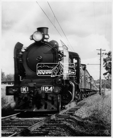
Photograph, Steam Train, 18 April 1971
... at Eltham, Diamond Creek and Wattle Glen stations on the afternoon... at Eltham, Diamond Creek and Wattle Glen stations on the afternoon ...Passengers hang out the windows of the vintage steam train as it travels along the Hurstbridge Railway Line. Regular trips travelled from Montmorency to Hurstbridge and return as part of the Shire of Eltham centenary program. The train also stopped at Eltham, Diamond Creek and Wattle Glen stations on the afternoon of Sunday 18th April 1971. This photo forms part of a collection of photographs gathered by the Shire of Eltham for their centenary project book, "Pioneers and Painters: 100 years of the Shire of Eltham" by Alan Marshall (1971). The collection of over 500 images is held in partnership between Eltham District Historical Society and Yarra Plenty Regional Library (Eltham Library) and is now formally known as 'The Shire of Eltham Pioneers Photograph Collection.' It is significant in being the first community sourced collection representing the places and people of the Shire's first one hundred years.Digital imagesepp, shire of eltham pioneers photograph collection, shire of eltham, shire of eltham centenary, centenary celebrations, steam train -
 Eltham District Historical Society Inc
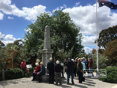
Photograph, Peter Pidgeon, Eltham War Memorial, 903-907 Main Road, Eltham, 4 November 2017, 4 Nov 2017
... in area and situated east of the Diamond Creek and north of Henry... in area and situated east of the Diamond Creek and north of Henry ...Eltham District Historical Society heritage walk to follow the boundaries of the original Shillinglaw Farm in central Eltham, held Saturday, 4th November, 2017. The Shillinglaw Farm comprised Lot 90 of Holloway’s 1851 Little Eltham subdivision. It was originally 30 acres in area and situated east of the Diamond Creek and north of Henry Street.Born digital imageeltham war memorial, obelisk, war memorial buidings, war memorial hall -
 Eltham District Historical Society Inc
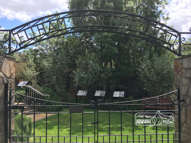
Photograph, Peter Pidgeon, Eltham War Memorial, 903-907 Main Road, Eltham, 4 November 2017, 4 Nov 2017
... in area and situated east of the Diamond Creek and north of Henry... in area and situated east of the Diamond Creek and north of Henry ...Eltham District Historical Society heritage walk to follow the boundaries of the original Shillinglaw Farm in central Eltham, held Saturday, 4th November, 2017. The Shillinglaw Farm comprised Lot 90 of Holloway’s 1851 Little Eltham subdivision. It was originally 30 acres in area and situated east of the Diamond Creek and north of Henry Street.Born digital imagecr. e.j. andrew, eltham war memorial, ernie andrew, war memorial buidings, war memorial garden, war memorial gates -
 Eltham District Historical Society Inc
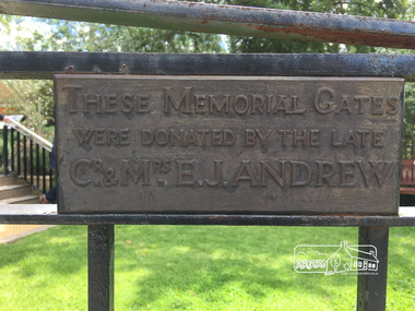
Photograph, Peter Pidgeon, Eltham War Memorial, 903-907 Main Road, Eltham, 4 November 2017, 4 Nov 2017
... in area and situated east of the Diamond Creek and north of Henry... in area and situated east of the Diamond Creek and north of Henry ...Eltham District Historical Society heritage walk to follow the boundaries of the original Shillinglaw Farm in central Eltham, held Saturday, 4th November, 2017. The Shillinglaw Farm comprised Lot 90 of Holloway’s 1851 Little Eltham subdivision. It was originally 30 acres in area and situated east of the Diamond Creek and north of Henry Street.Born digital imagecr. e.j. andrew, eltham war memorial, ernie andrew, war memorial buidings, war memorial garden, war memorial gates -
 Greensborough Historical Society
Book, Nillumbik Shire Council, 1997 Community Guide Nillumbik, 1997_
... is predominantly urban, with commercial centres at Eltham and Diamond Creek..., with commercial centres at Eltham and Diamond Creek. The north ...Guide to services provided by Nillumbik Shire Council. Nillumbik Shire is located 25 kilometres north-east of Melbourne and the southern boundary is the Yarra River. The south of Nillumbik is predominantly urban, with commercial centres at Eltham and Diamond Creek. The north of the municipality includes significant natural features like Kinglake National Park and Sugarloaf ReservoirAnnual guide to services in Nillumbik. 64 pages. Cover is pale yellow with colour drawings. nillumbik shire council, handbooks -
 Greensborough Historical Society
Book, Nillumbik Shire Council, 1998 Community Guide Nillumbik, 1998_
... is predominantly urban, with commercial centres at Eltham and Diamond Creek..., with commercial centres at Eltham and Diamond Creek. The north ...Guide to services provided by Nillumbik Shire Council. Nillumbik Shire is located 25 kilometres north-east of Melbourne and the southern boundary is the Yarra River. The south of Nillumbik is predominantly urban, with commercial centres at Eltham and Diamond Creek. The north of the municipality includes significant natural features like Kinglake National Park and Sugarloaf ReservoirAnnual guide to services in Nillumbik 72 pages. Cover has white background and some 3-D artwork.nillumbik shire council, handbooks -
 Greensborough Historical Society
Book, Nillumbik Shire Council, 1999 Community Guide Nillumbik, 1999_
... is predominantly urban, with commercial centres at Eltham and Diamond Creek..., with commercial centres at Eltham and Diamond Creek. The north ...Guide to services provided by Nillumbik Shire Council. Nillumbik Shire is located 25 kilometres north-east of Melbourne and the southern boundary is the Yarra River. The south of Nillumbik is predominantly urban, with commercial centres at Eltham and Diamond Creek. The north of the municipality includes significant natural features like Kinglake National Park and Sugarloaf ReservoirAnnual guide to services in Nillumbik76 pages, illus. Cover has photographs of local people and title in white on orange background.nillumbik shire council, handbooks -
 Greensborough Historical Society
Book, Nillumbik Shire Council, Nillumbik Community Guide 2000/2001, 2000-2001
... is predominantly urban, with commercial centres at Eltham and Diamond Creek..., with commercial centres at Eltham and Diamond Creek. The north ...Guide to services provided by Nillumbik Shire Council. Nillumbik Shire is located 25 kilometres north-east of Melbourne and the southern boundary is the Yarra River. The south of Nillumbik is predominantly urban, with commercial centres at Eltham and Diamond Creek. The north of the municipality includes significant natural features like Kinglake National Park and Sugarloaf ReservoirAnnual guide to services in Nillumbik76 pages, black and white illustrations. Cover has a collage of local children with title in white on mid-blue background.nillumbik shire council, handbooks -
 Greensborough Historical Society
Map, Melbourne and Metropolitan Board of Works. Survey Division, MMBW, Yarra 2500 / 15.21. Eltham North, 1979_08
... include the Diamond Creek, Eltham Council Pound and Eltham North... Road. Features include the Diamond Creek, Eltham Council Pound ...Melbourne and Metropolitan Board of Works. Yarra 2500 [base map] 15.21. Eltham North. Parish of Nillumbik 3310. Municipalities of Diamond Valley 257 and Eltham 238. Prominent streets include: Progress Road, Glen Park Road and Zig Zag Road. Features include the Diamond Creek, Eltham Council Pound and Eltham North Reserve.MMBW Map in 1:2500 [scale] series. Cream parchment with green tape reinforcing on edges and punched holes on left edge.mmbw, melbourne and metropolitan board of works, shire of diamond valley, nillumbik, eltham - maps -
 Eltham District Historical Society Inc
Newsletter, Newsletter, No. 140 September 2001
... Excursion – The Diamond Creek • Dunmoochin • Nina Christesen AM 1911... Excursion – The Diamond Creek • Dunmoochin • Nina Christesen AM 1911 ...Contents: • Next meeting, guest speaker; Harry Gilham: Kangaroo Ground War Memorial Update • September Meeting • Spring Excursion – The Diamond Creek • Dunmoochin • Nina Christesen AM 1911-2001 • Kangaroo Ground Events • Volunteer Recognition Project • Other News • Kangaroo Ground Cemetery 1851-2001: 150th Anniversary Celebrations The Shire of Eltham Historical Society was formed in October 1967. The first newsletter of the Society was issued May 1978 and has been published continuously ever since on a bi-monthly basis. With the cessation of the Shire of Eltham in late 1994, the Society's name was revised to Eltham District Historical Society and this name first appeared with issue No. 103, July 1995. The collection of the Society's newsletters provides a valuable resource on the history of the Society's activities, office bearers and committee members, guest speakers and subjects of historical interest pertinent to the former Shire of Eltham and the Eltham District.A4 photocopied newsletter distributed to membersnewsletter, eltham district historical society, shire of eltham historical society -
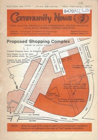 Greensborough Historical Society
Newsletter, Greenhills and North Greensborough Progress Association, Community News: official journal of the Greenhills and Nth. Greensborough Progress Association and the Apollo Parkways Progress Association.10th February, 1977. Edition No. 1/77, 10/02/1977
... despair, Grow, Co-operative education in Diamond Creek... despair, Grow, Co-operative education in Diamond Creek ...Proposed shopping complex - Public meeting, Super shops, Letters to the Editor, From the Council Chamber, Freedom from despair, Grow, Co-operative education in Diamond Creek, This and that,. Supplement to "Community News". No. 1/77. Geoff Kerry has a... Community News "family chat". A digital copy of this Newsletter is available from Greensborough Historical Society. Newsletter, 20 p., illus., map.greenhills and north greensborough progress association, greenhills, apollo parkways progress association, apollo parkways -
 Eltham District Historical Society Inc
Slide - Photograph, Shillinglaw Cottage, Eltham Common, Panther Place, Eltham, 27 May 1990
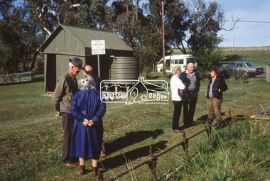
... (Diamond Creek), St Katherines (St Helena) Hurst family graves... (Diamond Creek), St Katherines (St Helena) Hurst family graves ...Local Cemetery Excursion Sunday 27 May 1990 departed Eltham Shire Office at 9.30am and finish mid afternoon. Visits to Eltham , Kangaroo Ground, Queenstown (Smiths Gully), Nillumbik (Diamond Creek), St Katherines (St Helena) Hurst family graves at Hurstbridge and a little known early cemetery at Grteensborough. Attended by 20 members. In each case we were introduced to the cemetery with a brief talk. At Eltham, Frank Burgoyne gave us the benefit of his knowledge as a member of the cemetery trust and at Kangaroo Ground, Bruce Ness spoke in a similar capacity. The lunch stop was at Hurstbridge where we visited the Hurst family graves. The President of Nillumbik Historical Society, Jock Ryan, joined us at the Nillumbik (Diamond Creek) cemetery. He travelled on to St Katherines, St Helena, where he talked on the history of the church and cemetery.35mm colour positive transparency (1 of 25) Mount - Kodak EktachromeProcessing Date Code Jun 90Mshillinglaw cottage, eltham common, panther place, eltham, activities, shire of eltham historical society, cemetery excursion -
 Eltham District Historical Society Inc
Slide - Photograph, Eltham Shire Council Offices, 895 Main Road, Eltham, 27 May 1990
... (Diamond Creek), St Katherines (St Helena) Hurst family graves... (Diamond Creek), St Katherines (St Helena) Hurst family graves ...Local Cemetery Excursion Sunday 27 May 1990 departed Eltham Shire Office at 9.30am and finish mid afternoon. Visits to Eltham , Kangaroo Ground, Queenstown (Smiths Gully), Nillumbik (Diamond Creek), St Katherines (St Helena) Hurst family graves at Hurstbridge and a little known early cemetery at Grteensborough. Attended by 20 members. In each case we were introduced to the cemetery with a brief talk. At Eltham, Frank Burgoyne gave us the benefit of his knowledge as a member of the cemetery trust and at Kangaroo Ground, Bruce Ness spoke in a similar capacity. The lunch stop was at Hurstbridge where we visited the Hurst family graves. The President of Nillumbik Historical Society, Jock Ryan, joined us at the Nillumbik (Diamond Creek) cemetery. He travelled on to St Katherines, St Helena, where he talked on the history of the church and cemetery.35mm colour positive transparency (1 of 25) Mount - Kodak EktachromeProcessing Date Code Jun 90Meltham, activities, shire of eltham historical society, cemetery excursion, eltham shire office, panther place -
 Eltham District Historical Society Inc
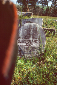
Slide - Photograph, Eltham Cemetery, Mt Pleasant Road, Eltham, 27 May 1990
... (Diamond Creek), St Katherines (St Helena) Hurst family graves... (Diamond Creek), St Katherines (St Helena) Hurst family graves ...Local Cemetery Excursion Sunday 27 May 1990 departed Eltham Shire Office at 9.30am and finish mid afternoon. Visits to Eltham , Kangaroo Ground, Queenstown (Smiths Gully), Nillumbik (Diamond Creek), St Katherines (St Helena) Hurst family graves at Hurstbridge and a little known early cemetery at Grteensborough. Attended by 20 members. In each case we were introduced to the cemetery with a brief talk. At Eltham, Frank Burgoyne gave us the benefit of his knowledge as a member of the cemetery trust and at Kangaroo Ground, Bruce Ness spoke in a similar capacity. The lunch stop was at Hurstbridge where we visited the Hurst family graves. The President of Nillumbik Historical Society, Jock Ryan, joined us at the Nillumbik (Diamond Creek) cemetery. He travelled on to St Katherines, St Helena, where he talked on the history of the church and cemetery.35mm colour positive transparency (1 of 23) Mount - Agfachrome Agfa CS System black 8 dotseltham, activities, shire of eltham historical society, cemetery excursion, eltham cemetery, frank burgoyne -
 Eltham District Historical Society Inc
Slide - Photograph, Eltham Cemetery, Mt Pleasant Road, Eltham, 27 May 1990
... (Diamond Creek), St Katherines (St Helena) Hurst family graves... (Diamond Creek), St Katherines (St Helena) Hurst family graves ...Local Cemetery Excursion Sunday 27 May 1990 departed Eltham Shire Office at 9.30am and finish mid afternoon. Visits to Eltham , Kangaroo Ground, Queenstown (Smiths Gully), Nillumbik (Diamond Creek), St Katherines (St Helena) Hurst family graves at Hurstbridge and a little known early cemetery at Grteensborough. Attended by 20 members. In each case we were introduced to the cemetery with a brief talk. At Eltham, Frank Burgoyne gave us the benefit of his knowledge as a member of the cemetery trust and at Kangaroo Ground, Bruce Ness spoke in a similar capacity. The lunch stop was at Hurstbridge where we visited the Hurst family graves. The President of Nillumbik Historical Society, Jock Ryan, joined us at the Nillumbik (Diamond Creek) cemetery. He travelled on to St Katherines, St Helena, where he talked on the history of the church and cemetery.35mm colour positive transparency (1 of 23) Mount - Agfachrome Agfa CS System black 8 dotseltham, activities, shire of eltham historical society, cemetery excursion, eltham cemetery, frank burgoyne -
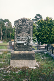 Eltham District Historical Society Inc
Slide - Photograph, Eltham Cemetery, Mt Pleasant Road, Eltham, 27 May 1990
... (Diamond Creek), St Katherines (St Helena) Hurst family graves... (Diamond Creek), St Katherines (St Helena) Hurst family graves ...Local Cemetery Excursion Sunday 27 May 1990 departed Eltham Shire Office at 9.30am and finish mid afternoon. Visits to Eltham , Kangaroo Ground, Queenstown (Smiths Gully), Nillumbik (Diamond Creek), St Katherines (St Helena) Hurst family graves at Hurstbridge and a little known early cemetery at Grteensborough. Attended by 20 members. In each case we were introduced to the cemetery with a brief talk. At Eltham, Frank Burgoyne gave us the benefit of his knowledge as a member of the cemetery trust and at Kangaroo Ground, Bruce Ness spoke in a similar capacity. The lunch stop was at Hurstbridge where we visited the Hurst family graves. The President of Nillumbik Historical Society, Jock Ryan, joined us at the Nillumbik (Diamond Creek) cemetery. He travelled on to St Katherines, St Helena, where he talked on the history of the church and cemetery.35mm colour positive transparency (1 of 23) Mount - Agfachrome Agfa CS System black 8 dotseltham, activities, shire of eltham historical society, cemetery excursion, eltham cemetery, graves, mary o'callaghan, patrick o'callaghan, timothy o'callaghan -
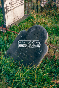
 Eltham District Historical Society Inc
Slide - Photograph, Eltham Cemetery, Mt Pleasant Road, Eltham, 27 May 1990
... (Diamond Creek), St Katherines (St Helena) Hurst family graves... (Diamond Creek), St Katherines (St Helena) Hurst family graves ...Local Cemetery Excursion Sunday 27 May 1990 departed Eltham Shire Office at 9.30am and finish mid afternoon. Visits to Eltham , Kangaroo Ground, Queenstown (Smiths Gully), Nillumbik (Diamond Creek), St Katherines (St Helena) Hurst family graves at Hurstbridge and a little known early cemetery at Grteensborough. Attended by 20 members. In each case we were introduced to the cemetery with a brief talk. At Eltham, Frank Burgoyne gave us the benefit of his knowledge as a member of the cemetery trust and at Kangaroo Ground, Bruce Ness spoke in a similar capacity. The lunch stop was at Hurstbridge where we visited the Hurst family graves. The President of Nillumbik Historical Society, Jock Ryan, joined us at the Nillumbik (Diamond Creek) cemetery. He travelled on to St Katherines, St Helena, where he talked on the history of the church and cemetery.35mm colour positive transparency (1 of 23) Mount - Agfachrome Agfa CS System black 8 dotseltham, activities, shire of eltham historical society, cemetery excursion, eltham cemetery, graves, annie sweeney, caroline sweeney, ellen sweeney, johanna sweeney, john sweeney, margaret sweeney, thomas sweeney -
 Eltham District Historical Society Inc
Slide - Photograph, Eltham Cemetery, Mt Pleasant Road, Eltham, 27 May 1990
... (Diamond Creek), St Katherines (St Helena) Hurst family graves... (Diamond Creek), St Katherines (St Helena) Hurst family graves ...Local Cemetery Excursion Sunday 27 May 1990 departed Eltham Shire Office at 9.30am and finish mid afternoon. Visits to Eltham , Kangaroo Ground, Queenstown (Smiths Gully), Nillumbik (Diamond Creek), St Katherines (St Helena) Hurst family graves at Hurstbridge and a little known early cemetery at Grteensborough. Attended by 20 members. In each case we were introduced to the cemetery with a brief talk. At Eltham, Frank Burgoyne gave us the benefit of his knowledge as a member of the cemetery trust and at Kangaroo Ground, Bruce Ness spoke in a similar capacity. The lunch stop was at Hurstbridge where we visited the Hurst family graves. The President of Nillumbik Historical Society, Jock Ryan, joined us at the Nillumbik (Diamond Creek) cemetery. He travelled on to St Katherines, St Helena, where he talked on the history of the church and cemetery.35mm colour positive transparency (1 of 23) Mount - Agfachrome Agfa CS System black 8 dotseltham, activities, shire of eltham historical society, cemetery excursion, eltham cemetery, graves, edith lawlor, margaret lawlor, maud lawlor, michael lawlor, peter lawlor -
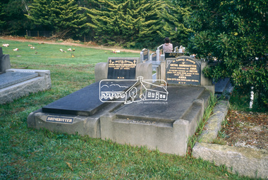 Eltham District Historical Society Inc
Slide - Photograph, Eltham Cemetery, Mt Pleasant Road, Eltham, 27 May 1990
... (Diamond Creek), St Katherines (St Helena) Hurst family graves... (Diamond Creek), St Katherines (St Helena) Hurst family graves ...Local Cemetery Excursion Sunday 27 May 1990 departed Eltham Shire Office at 9.30am and finish mid afternoon. Visits to Eltham , Kangaroo Ground, Queenstown (Smiths Gully), Nillumbik (Diamond Creek), St Katherines (St Helena) Hurst family graves at Hurstbridge and a little known early cemetery at Grteensborough. Attended by 20 members. In each case we were introduced to the cemetery with a brief talk. At Eltham, Frank Burgoyne gave us the benefit of his knowledge as a member of the cemetery trust and at Kangaroo Ground, Bruce Ness spoke in a similar capacity. The lunch stop was at Hurstbridge where we visited the Hurst family graves. The President of Nillumbik Historical Society, Jock Ryan, joined us at the Nillumbik (Diamond Creek) cemetery. He travelled on to St Katherines, St Helena, where he talked on the history of the church and cemetery.35mm colour positive transparency (1 of 23) Mount - Agfachrome Agfa CS System black 8 dotseltham, activities, shire of eltham historical society, cemetery excursion, eltham cemetery, graves, anna brinkkotter, anton brinkkotter, anton william brinkkotter -
 Eltham District Historical Society Inc
Slide - Photograph, Eltham Cemetery, Mt Pleasant Road, Eltham, 27 May 1990
... (Diamond Creek), St Katherines (St Helena) Hurst family graves... (Diamond Creek), St Katherines (St Helena) Hurst family graves ...Local Cemetery Excursion Sunday 27 May 1990 departed Eltham Shire Office at 9.30am and finish mid afternoon. Visits to Eltham , Kangaroo Ground, Queenstown (Smiths Gully), Nillumbik (Diamond Creek), St Katherines (St Helena) Hurst family graves at Hurstbridge and a little known early cemetery at Grteensborough. Attended by 20 members. In each case we were introduced to the cemetery with a brief talk. At Eltham, Frank Burgoyne gave us the benefit of his knowledge as a member of the cemetery trust and at Kangaroo Ground, Bruce Ness spoke in a similar capacity. The lunch stop was at Hurstbridge where we visited the Hurst family graves. The President of Nillumbik Historical Society, Jock Ryan, joined us at the Nillumbik (Diamond Creek) cemetery. He travelled on to St Katherines, St Helena, where he talked on the history of the church and cemetery.35mm colour positive transparency (1 of 23) Mount - Agfachrome Agfa CS System black 8 dotseltham, activities, shire of eltham historical society, cemetery excursion, eltham cemetery, graves -
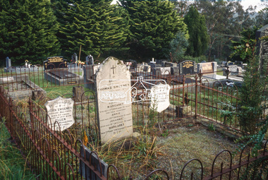
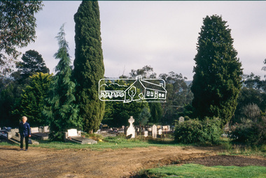
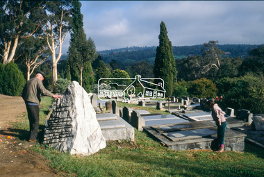
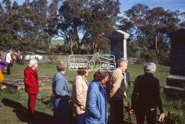 Eltham District Historical Society Inc
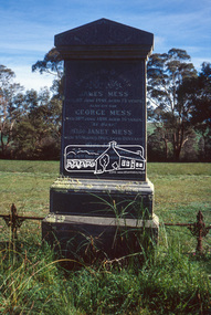
Slide - Photograph, Kangaroo Ground Cemetery, Cemetery Road, Kangaroo Ground, 27 May 1990
... (Diamond Creek), St Katherines (St Helena) Hurst family graves... (Diamond Creek), St Katherines (St Helena) Hurst family graves ...Local Cemetery Excursion Sunday 27 May 1990 departed Eltham Shire Office at 9.30am and finish mid afternoon. Visits to Eltham , Kangaroo Ground, Queenstown (Smiths Gully), Nillumbik (Diamond Creek), St Katherines (St Helena) Hurst family graves at Hurstbridge and a little known early cemetery at Grteensborough. Attended by 20 members. In each case we were introduced to the cemetery with a brief talk. At Eltham, Frank Burgoyne gave us the benefit of his knowledge as a member of the cemetery trust and at Kangaroo Ground, Bruce Ness spoke in a similar capacity. The lunch stop was at Hurstbridge where we visited the Hurst family graves. The President of Nillumbik Historical Society, Jock Ryan, joined us at the Nillumbik (Diamond Creek) cemetery. He travelled on to St Katherines, St Helena, where he talked on the history of the church and cemetery.35mm colour positive transparency (1 of 23) Mount - Agfachrome Agfa CS System black 8 dotsshire of eltham historical society, cemetery excursion, graves, activities, george mess, james mess, jane mess, janet mess, joseph mess, kangaroo ground cemetery -
 Eltham District Historical Society Inc
Slide - Photograph, Kangaroo Ground Cemetery, Cemetery Road, Kangaroo Ground, 27 May 1990
... (Diamond Creek), St Katherines (St Helena) Hurst family graves... (Diamond Creek), St Katherines (St Helena) Hurst family graves ...Local Cemetery Excursion Sunday 27 May 1990 departed Eltham Shire Office at 9.30am and finish mid afternoon. Visits to Eltham , Kangaroo Ground, Queenstown (Smiths Gully), Nillumbik (Diamond Creek), St Katherines (St Helena) Hurst family graves at Hurstbridge and a little known early cemetery at Grteensborough. Attended by 20 members. In each case we were introduced to the cemetery with a brief talk. At Eltham, Frank Burgoyne gave us the benefit of his knowledge as a member of the cemetery trust and at Kangaroo Ground, Bruce Ness spoke in a similar capacity. The lunch stop was at Hurstbridge where we visited the Hurst family graves. The President of Nillumbik Historical Society, Jock Ryan, joined us at the Nillumbik (Diamond Creek) cemetery. He travelled on to St Katherines, St Helena, where he talked on the history of the church and cemetery.35mm colour positive transparency (1 of 23) Mount - Agfachrome Agfa CS System black 8 dotsshire of eltham historical society, cemetery excursion, graves, activities, joseph mess, kangaroo ground cemetery -
 Eltham District Historical Society Inc
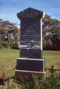
Slide - Photograph, Kangaroo Ground Cemetery, Cemetery Road, Kangaroo Ground, 27 May 1990
... (Diamond Creek), St Katherines (St Helena) Hurst family graves... (Diamond Creek), St Katherines (St Helena) Hurst family graves ...Local Cemetery Excursion Sunday 27 May 1990 departed Eltham Shire Office at 9.30am and finish mid afternoon. Visits to Eltham , Kangaroo Ground, Queenstown (Smiths Gully), Nillumbik (Diamond Creek), St Katherines (St Helena) Hurst family graves at Hurstbridge and a little known early cemetery at Grteensborough. Attended by 20 members. In each case we were introduced to the cemetery with a brief talk. At Eltham, Frank Burgoyne gave us the benefit of his knowledge as a member of the cemetery trust and at Kangaroo Ground, Bruce Ness spoke in a similar capacity. The lunch stop was at Hurstbridge where we visited the Hurst family graves. The President of Nillumbik Historical Society, Jock Ryan, joined us at the Nillumbik (Diamond Creek) cemetery. He travelled on to St Katherines, St Helena, where he talked on the history of the church and cemetery.35mm colour positive transparency (1 of 23) Mount - Agfachrome Agfa CS System black 8 dotsshire of eltham historical society, cemetery excursion, graves, activities, kangaroo ground cemetery, david stevenson, joseph stevenson, ruth stevenson -
 Eltham District Historical Society Inc
Slide - Photograph, Kangaroo Ground Cemetery, Cemetery Road, Kangaroo Ground, 27 May 1990
... (Diamond Creek), St Katherines (St Helena) Hurst family graves... (Diamond Creek), St Katherines (St Helena) Hurst family graves ...Local Cemetery Excursion Sunday 27 May 1990 departed Eltham Shire Office at 9.30am and finish mid afternoon. Visits to Eltham , Kangaroo Ground, Queenstown (Smiths Gully), Nillumbik (Diamond Creek), St Katherines (St Helena) Hurst family graves at Hurstbridge and a little known early cemetery at Grteensborough. Attended by 20 members. In each case we were introduced to the cemetery with a brief talk. At Eltham, Frank Burgoyne gave us the benefit of his knowledge as a member of the cemetery trust and at Kangaroo Ground, Bruce Ness spoke in a similar capacity. The lunch stop was at Hurstbridge where we visited the Hurst family graves. The President of Nillumbik Historical Society, Jock Ryan, joined us at the Nillumbik (Diamond Creek) cemetery. He travelled on to St Katherines, St Helena, where he talked on the history of the church and cemetery.35mm colour positive transparency (1 of 23) Mount - Agfachrome Agfa CS System black 8 dotsshire of eltham historical society, cemetery excursion, graves, activities, kangaroo ground cemetery