Showing 3710 items matching "landscaping"
-
 University of Melbourne, Burnley Campus Archives
Plan, Garden Advisory Centre Summer House. Landscape working drawing 1:50, 1985
Copy of Landscape Working Drawing for the Agriculture Research Institute by the Public Works Department, Victoria No 85-523 L1/1 dated 30.01.1985. Scale 1:50.garden advisory centre, summer house, agriculture research institute, victoria public works department, landscape drawing, burnley gardens -
 Whitehorse Historical Society Inc.
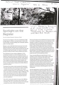
Article - National Trust of Australia (Victoria) Magazine, National Trust of Australia, Boongarry Avenue, Blackburn, Autumn 2023???
A photocopy of an article from the Victorian National Trust magazine pertaining to the inclusion of Boongarry Avenue for landscape classification within the Blackburn Lake and Bell Bird Streets, Blackburn.A photocopy of an article from the Victorian National Trust magazine pertaining to the inclusion of Boongarry Avenue for landscape classification within the Blackburn Lake and Bell Bird Streets, Blackburn.non-fictionA photocopy of an article from the Victorian National Trust magazine pertaining to the inclusion of Boongarry Avenue for landscape classification within the Blackburn Lake and Bell Bird Streets, Blackburn.boongarry avenue blackburn, blackburn lake, national trust of australia victoria -
 Ballarat Tramway Museum
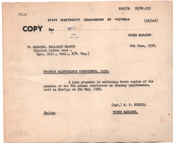
Administrative record, State Electricity Commission of Victoria (SECV), "Notes for 8th Annual Conference", 1958
Set of notes for the Provincial Tramways Maintenance meeting to be held in Bendigo - 5/5/1958. Has a summary of actions from the 1957 conference, and an Agenda. One page of a multipage document titled "Some notes on the Agenda" dated 28/4/1958 reporting on track condition, life cycle on special work, flange running sections and rail hardness. Second loose sheet follows on from the 1957 conference, - rolling stock tyres, track maintenance - joining of rails and concrete sets. Memo dated 6/6/1958 from the Works Manager to Manager Ballarat branch forwarding a copy of the minutes of the conference held in Bendigo on 5/5/1968. These minutes are not in the collection as of April 2025.Yields information and demonstrates SEC Meeting minutes about discussions between the three Provincial operators about tramcars and operations.Thirteen foolscap typed sheets stapled in a landscape format to a folded manila card and two loose typed foolscap sheets. Half size foolscap sheet - copy.secv, ballarat, trams, tramways, minutes, sec, geelong, bendigo, tramcar equipment, maintenance, trackwork, trolley wheels, motors, maximum traction, employees -
 Lakes Entrance Historical Society
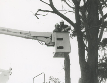
Photograph - Greg Jenkins and Scott Cassells of Lakes Entrance Landscapers, Lakes Post Newspaper, 1/06/1996 12:00:00 AM
Black and white photograph of Greg Jenkins and Scott Cassells of Lakes Entrance Landscapers in a cherry picker about to prune a tall tree with a chainsaw Lakes Entrance Victoriabusinesses, commerce -
 Returned Nurses RSL Sub-branch
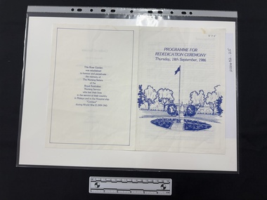
Document - Printed document, Programme for rededication ceremony : Thursday, 18th September 1986, [1986]
Programme for rededication ceremony of the Memorial Rose Garden from two previous locations on the hospital [Heidelberg Repatriation Hospital] grounds. Programme includes brief background, order of service and dedication.A printed document in blue ink on white paper, single fold with four pages. Front page has drawing of landscape with flagpole and all other pages are textual.'H75' [blue ink top right hand corner of front page]wwii, world war 2, australian army nursing service, aans, australian hospital ship centaur, heidelberg military hospital, wilma elizabeth forster oram, wilma elizabeth forster young -
 Glenelg Shire Council Cultural Collection
Print, Cape Bridgewater, 1993
Monotone image of windswept bush. Costal landscape. Bush in the foreground is leaning to the right. Grasses in the foreground. The image is mounted on off white board and frame in a black frame.3/15 (Second State) / Cape Bridgewater / Carmel Wallace '93cape bridgewater, drypoint, etch, etching, carmel wallace, landscape, coastal, female artist, female artists, portland -
 Robin Boyd Foundation
Document - Manuscript, Robin Boyd, Architecture in Seclusion, 1967
Boyd discusses Australia and New Zealand's search for their own 'modern' architectural style. Boyd points out the influence of the natural landscape that affects these designs and architectural decisions. In addition, he argues that the search for 'modern' architecture isn't rushed due to the need of respecting the natural landscape of both Australia and New ZealandOriginal manuscript of an article 'Australia in seclusion’ published in Journal of the New Zealand Institute of Architects, Vol. 34, September 1967, pp.270-275.Typewritten (c copy), foolscap, 21 pages (two copies of page 9)walter burley griffin, harold desbrowe annear, robert haddon, seabrook and fildes, roy grounds, geoffrey mewton, edward f. billson, best overent (overend), modern architecture, sydney opera house, ian mckay's c/b/ alexander presbyterian agriculture college, ernest kump, sydney school, california, robin boyd, manuscript -
 Phillip Island and District Historical Society Inc.
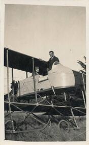
Photograph, Bi-plane on Phillip Island
From Jessie Smith's collection of Island Events & Landscapes. 1st plane to land at Phillip Island.Pilot sitting in Bi-plane. Man in suit welcoming.local history, photographs, transport, aviation, aircraft, phillip island, black & white photograph, jessie smith collection, stan mcfee -
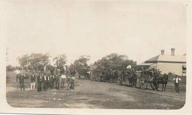 Phillip Island and District Historical Society Inc.
Photograph, Wood Day for Warley Hospital
From Jessie Smith's collection of local events and landscapes. Community activity to supply community facility.Horse & Drays in right background. Group of men in left foreground. Wood day at Warley Hospital.local history, photographs, buildings, historic, warley hospital, black & white photograph, jessie smith collection, stan mcfee -
Clunes Museum
Book, NATIONAL LIBRARY OF AUSTRALIA et al, CLUNES - A TOWNSCAPE STUDY OF A VICTORIAN COUNTRY TOWN
GENERALLY THIS SIDY IS AN ANALYSIS OF THE VISUAL FABRIC OF THE TOWN AND GIVES SUGGESTED GUIDELINES FOR FUTURE GROWTHBOOK - CLUNES - A TOWNSCAPE STUDY OF A VICTORIAN COUNTRY TOWN PRODUCED BY CENTRE FOR ENVIROMENTAL STUDIES. UNIVERSITY OF MELBOURNE 1977GENERALLY THIS SIDY IS AN ANALYSIS OF THE VISUAL FABRIC OF THE TOWN AND GIVES SUGGESTED GUIDELINES FOR FUTURE GROWTHlocal history, town scape -
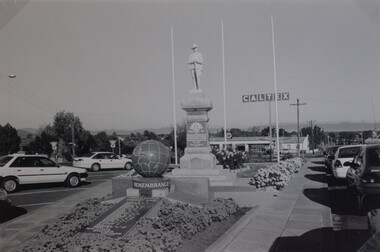 Stawell Historical Society Inc
Photograph, Soldiers’ Memorial World War 1 & World War 2 in Main Street
Soldiers’ Memorial and WW2 memorial. This photo shows the memorials in the surrounding landscape at the time, c.1999. Black & White photo showing both Memorials, WW1 and WW2. The Soldier's Memorial in the photo is behind the Remembrance Memorial. In the photo three flagpole stand behind the memorials. There is a Caltex sign in the background and cars surround the memorials. stawell ww1 ww2 -
University of Melbourne, Burnley Campus Archives
Newspaper - Newspaper Cutting, The Age, Innovator With a Touch of Blooming Magic, 2008
John Stevens, AM (1938), established Australia's first professional landscape architectural practice in 1952.Obituary of John Stevens, AM (1938) in "The Age" 31.05.2008 by Anne Latreille.the age, john stevens, obituary, anne latreille, landscape architecture -
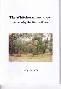 Whitehorse Historical Society Inc.
Booklet, The Whitehorse landscape, 2011
A booklet on the natural history of the Whitehorse landscape by Gary Preslandnon-fictionA booklet on the natural history of the Whitehorse landscape by Gary Preslandpresland gary, landscapes, native plants -
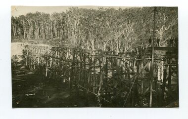 Orbost & District Historical Society
Photograph - Photograph. black + white
The Stony Creek Trestle Bridge was built in 1916 when the existing rail line from Melbourne to Bairnsdale was extended to Orbost. This 97km Bairnsdale to Orbost extension through rugged terrain was reputed to have been the most difficult rail project undertaken in Victoria. In service for over 60 years the bridge was damaged by bushfire in 1980, with the last train crossing in 1987. At 247m long and 20m high, it is the largest standing bridge of its kind in the State, and is listed on the Register of Historic Sites. Built of red ironbark and grey box timber, it is a fine example of the early engineering skills that utilised the resources and materials found on site. (More information Newsletter July 2013)Built during the period 1914-16, of Gippsland Grey Box and Red Ironbark, the Stoney Creek bridge on the East Gippsland Railway is a fine example of early engineering skilll , being constructed without the aid of any of the modern machinery available today. This is a rare photograph and of high significance in showing the bridge under construction.Landscape format black + white photograph (unframed). Four pin holes in each corner, tear to top left quadrant and fold / crease top to bottom in centre of image.construction, 1916, railway bridge, timber industry, trestle construction, stony creek bridge, east gippsland, bairnsdale to orbost line -
 Eltham District Historical Society Inc
Calendar, Nillumbik Community Calendar 1996: Nillumbik The Places and the People, 1995
Community Project. One of a series of calendars which the Shire of Eltham and the Shire of Nillumbik published annually Photography by Graham Hosking Photography. Monthly calendar printed in landscape mode, with feature photograph and template of dates for each of the 12 months presented. Includes advertisements. Back of the calendar includes a list of emergency numbers.calendar,1996,shire of nillumbik,research primary school,eltham north adventure playground,edendale gateway,tony trembath,eltham leisure centre,diamond valley railway,kangaroo ground pony club,eltham community and reception centre,eltham community centre,shire of nillumbik,swimming pool,yarra river,, diamond creek trail,yarrambat golf course,sugar loaf reservoir,map -
4th/19th Prince of Wales's Light Horse Regiment Unit History Room
Framed Photograph, 8th Light Horse Regiment, 1914
Landscape framed photograph showing 8th Light Horse Regiment, A Squadron leading returning from exercise in the Greensborough area after trialling Wileys (sic) field cooker8th Light Horse Regiment, A Squadron leading returning from exercise in the Greensborough area after trialling Wileys (sic) field cooker late 1914. Presented to the CO and members of the 4/19 PWLH Regiment from WO1 Allan Hawkins ASM 15 March 2005 -
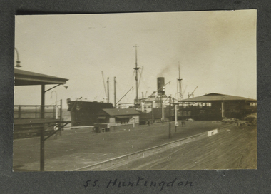 Mission to Seafarers Victoria
Photograph - Photograph, Sepia, SS Huntingdon, 1928
Possibly Station pier Port Melbournesmall b&w landscape photograph featuring a steamship moored at a railway pier, rail siding in foreground and shedding between rails and vessel. The smoke stack is faintly steaming.Handwritten in black ink on album page beneath image: SS Huntingdonss huntingdon, fan album -
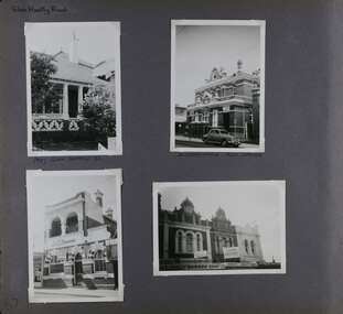
 Glen Eira Historical Society
Album - Album page, Nithsdale now Five Way Hill, Kambrook Road, Circa 1972
This photograph is part of the Caulfield Historical Album 1972. This album was created in approximately 1972 as part of a project by the Caulfield Historical Society to assist in identifying buildings worthy of preservation. The album is related to a Survey the Caulfield Historical Society developed in collaboration with the National Trust of Australia (Victoria) and Caulfield City Council to identify historic buildings within the City of Caulfield that warranted the protection of a National Trust Classification. Principal photographer thought to be Trevor Hart, member of Caulfield Historical Society. Most photographs were taken between 1966-1972 with a small number of photographs being older and from unknown sources. All photographs are black and white except where stated, with 386 photographs over 198 pages. Glen Eira Heritage Management Plan (1996) by Andrew Ward and Associates - Vol 3 "Nithsdale", built for J.S. Crouchin 1858 and extended in 1885 with a tower and associated rooms, survives as testimony to the nineteenth century occupation of the vicinity of the Kambrook/Glen Eira Road intersection. Caulfield's Building Heritage by Dr Geulah Solomon, Vol 1 p49 records it as a small Victorian mansion home on bluestone foundations of Italianate style with a tower. Built for J S Chambers circa 1860, it was built in stages and then the land subdivided in the 1920s. Other owners include Adolph F Brockhoff (of Brockhoff Biscuits company). Names used besides Nithsdale have been Bundoora and Five Way Hill. Page 102 of Photograph Album with four photographs (three landscape and one portrait) of Nithsdale, now known as Five Way Hill. Three views of the tower and one of the house.Handwritten: "Nithsdale" now "Five Way Hill" Kambrook road [top right] / CNR KAMBROOK AND GLENEIRA ROADS [under bottom right photo] / 102 [bottom right]trevor hart, north caulfield, victorian, mid victorian, late victorian, tower, j.s. crouchin, 1850's, 1880's, italianate, rendered, five way hill, nithsdale, slate roof, plaster arches, ornamental columns, triangular pediment, ornamental parapet, cast iron balconies, kambrook road, glen eira road, t crouch, j s crouchin, mansions, j s chambers, bluestone foundations, land subdivision, adolph f brockhoff, bundoora, house names -
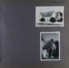 Glen Eira Historical Society
Album - Album page, Avoca Grove, 12, Circa 1972
This photograph is part of the Caulfield Historical Album 1972. This album was created in approximately 1972 as part of a project by the Caulfield Historical Society to assist in identifying buildings worthy of preservation. The album is related to a Survey the Caulfield Historical Society developed in collaboration with the National Trust of Australia (Victoria) and Caulfield City Council to identify historic buildings within the City of Caulfield that warranted the protection of a National Trust Classification. Principal photographer thought to be Trevor Hart, member of Caulfield Historical Society. Most photographs were taken between 1966-1972 with a small number of photographs being older and from unknown sources. All photographs are black and white except where stated, with 386 photographs over 198 pages.From Glen Eira Heritage Management Plan (1996) by Andrew Ward and Associates: The house at 12 Avoca Grove, part of "Merton", now demolished, is understood to have been built for and occupied by James Wilberforce Stephens from c.1865. It has aesthetic and historical significance. The building's aesthetic value is derived from the manner in which it demonstrates aspects of the Cottage Orne style, popular among Melboume's gentry during the mid Victorian period. Its historical value is derived from its association with J. W. Stephens, MLA, for East St Kilda and a prominent Caulfield resident.Page 20 of Photograph Album - two black and white exterior photographs of a house with both photographs on the right hand side of the page, the top in landscape mode and the bottom portrait. Hand written: 12 Avoca Grove [top right of page] / 20 [bottom right]trevor hart, avoca grove, church, caulfield north, merton, james wilberforce stephens, cottage orne style, j w stephens (mla) -
 Glen Eira Historical Society
Album - Album page, Glen Huntly Road, Circa 1972
This photograph is part of the Caulfield Historical Album 1972. This album was created in approximately 1972 as part of a project by the Caulfield Historical Society to assist in identifying buildings worthy of preservation. The album is related to a Survey the Caulfield Historical Society developed in collaboration with the National Trust of Australia (Victoria) and Caulfield City Council to identify historic buildings within the City of Caulfield that warranted the protection of a National Trust Classification. Principal photographer thought to be Trevor Hart, member of Caulfield Historical Society. Most photographs were taken between 1966-1972 with a small number of photographs being older and from unknown sources. All photographs are black and white except where stated, with 386 photographs over 198 pages. The Former Elsternwick Post Office is on the Victorian Heritage Register H0640 with a full significance statement and also HO29 with the City of Glen Eira. Much of the Glen Huntly Road heritage retail strip is heritage listed in HO72 with the City of Glen Eira.Page 67 of Photograph Album with four photographs (three portrait and one landscape) of different properties on Glen Huntly Road - a house, Post Office, ANZ Bank and shops.Hand written: Glen Huntly Road [top left] / 1027 GLEN HUNTLY RD [under top left photo] / ELSTERNWICK POST OFFICE [under top right photo] / 67 [bottom left] trevor hart, glen huntly road, elsternwick, shops, caulfield, post offices, glenhuntly road, banks, brick houses, shopping centres -
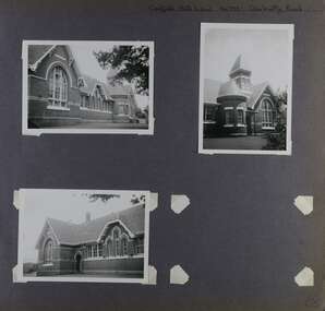 Glen Eira Historical Society
Album - Album page, Caulfield State School, No 773, Glen Huntly Road, Circa 1972
This photograph is part of the Caulfield Historical Album 1972. This album was created in approximately 1972 as part of a project by the Caulfield Historical Society to assist in identifying buildings worthy of preservation. The album is related to a Survey the Caulfield Historical Society developed in collaboration with the National Trust of Australia (Victoria) and Caulfield City Council to identify historic buildings within the City of Caulfield that warranted the protection of a National Trust Classification. Principal photographer thought to be Trevor Hart, member of Caulfield Historical Society. Most photographs were taken between 1966-1972 with a small number of photographs being older and from unknown sources. All photographs are black and white except where stated, with 386 photographs over 198 pages.From: Glen Eira Heritage Management Plan (1996) by Andrew Ward and Associates Caulfield State School No. 773 is important at the State level as the first of similar designs for small schools prepared by the Education Department under H.R. Bastow at Little Bendigo (1878), Glen Waverley (1880), Ascot (1882), Sandringham (1885) and Carlsrich (1892)·. It is a representative example of the Department's Gothic Revival designs, distinguished, however, by the semicircular treatment of the master's office, which compares with Portland (1879), Queensberry St Carlton (1880) and Footscray (1881). It has local significance as the earliest surviving Government School in Caulfield and as a centre for education from 1877, comparing with St. Mary's Jubilee School (qv) of 1887. The Caulfield State School of 1877, the horse tramway of 1889 and subsequently the electric trams were all events confirming the importance of Glenhuntly Road and the fledgling community of "Camden Town" wherein the City's commercial centre has its origins.Page 68 of Photograph Album with three exterior photographs (two portrait and one landscape) of one side of Caulfield State School with a fourth photo missing from the page.Hand written: Caulfield State School No. 773 Glenhuntly Road [top right] / 68 [bottom right] trevor hart, glen huntly road, caulfield state school, caulfield primary school, gothic revival, schools, caulfield south, arched window, tower, 1870's, camden town, red brick, curved windows, terracotta tiles, master's office, education, primary school, glenhuntly road, h r bastow -
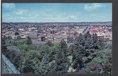 Bendigo Historical Society Inc.
Postcard - PANORAMA FROM ROSALIND PARK LOOKOUT TOWER
Colour postcard, showing landscape view of Bendigo taken from lookout tower in Rosalind Park. Trees in foreground, looking eastward, Shamrock Hotel, city block in foreground.Nu-Color-Vuebendigo, parks and gardens, lookout tower view, bendigo, rosalind park -
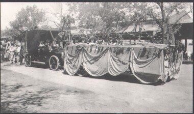 Bendigo Historical Society Inc.
Photograph - B&W photograph of a "float" for the Myer Store for the Bendigo Easter Fair
Early 1900s streetscape of major intersection in BendigoLandscape format. B&W photograph of a "float" for the Myer Store entered in the Bendigo Easter Fair, undated early 1900s photograph. Four people representing Myer on the floatsocial history -
 Bendigo Historical Society Inc.
Photograph - VIEWS OF VICTORIA NO 13
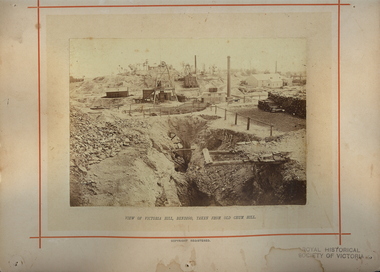
Views of Victoria No 13. View of Victoria Hill Bendigo taken from Old Chum Hill. North Old Chum, New Chum and Victoria Companies. Mining landscape -
 Bendigo Historical Society Inc.
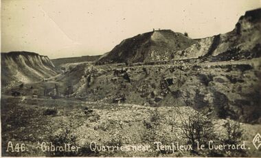
Postcard - ACC LOCK COLLECTION: 'GIBRALTER' QUARRIES NEARTEMPLEUX LE GUERRARD, POSTCARD, 1914-1918
Postcard, WW1, B&W image of the 'Gibralter' quarries near Templeux le Guerrard.Sparse rocky landscape with a lone figure on top of a hillock in background. One copy A46postcard, postcard, ww1, gibralter, quarry, templeux le guerrard, france -
 Hume City Civic Collection
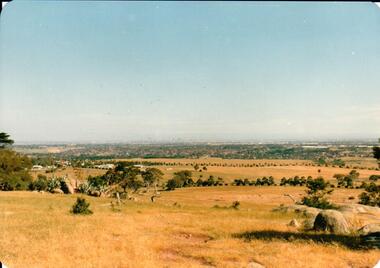
Photograph, early 1980s
The Tullamarine Airport opened in 1970 and replaced Essendon Airport as Melbourne's main airport terminal. Gellibrand Hill was incorporated with Woodlands Park and became a public reserve during the 1980s.A coloured landscape photograph with rounded corners taken from Gellibrand Hill and overlooking the Tullamarine Airport which is on the RHS of the photograph. The Melbourne City skyline can be seen in the distance.gellibrand hill, tullamarine airport, melbourne skyline, george evans collection -
Clunes Museum
Souvenir - SOUVENIR FOLDER, JOIN US ON A TRIP AROUND CLUNES
5 X COPIES SOUVENIR - CREAM COLOURED FOLDER WITH DARK TITLE PRINTED ON FRONT CONTAINING 7 X BLACK & WHITE IMAGES OF CLUNES LANDSCAPE PANORAMA AND BUILDINGSlocal history, document, souvenir postcards, souvenir folder, buildings -
 Nillumbik Shire Council
Painting: John DUDLEY, John Dudley, Night Predators, 1960s/70s
John Dudley was a well-known local artist who lived in the Shire during the 50s, 60’s and 70s. He was represented by Wiregrass Gallery in Eltham. Formerly two separate galleries: The Eltham Gallery and The Wiregrass Gallery. The Wiregrass Gallery opened on 4th February 1977 at Station Entrance, Eltham, Victoria and closed on the 19th November 1989 when its lease expired. The gallery then moved in early 1990 to 559 Main Road Eltham, the premises of the Eltham Gallery and from then on operated under the name Eltham Wiregrass Gallery. This work is of the local environment and an excellent example of the artist’s work practice.A visual language of shape, form and colour (abstract) to create a composition referencing the physical and emotional experience of landscape. Blended colours of dark blues in background and warm yellows in foreground. Signed 'Dudley' red paint, lower left.landscape, abstract, eltham -
 Nillumbik Shire Council
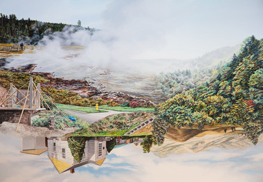
Painting: Kevin CHIN, Kevin Chin, Castle Under the Sky, 2018
This painting was sparked by a US studio residency at Yellowstone National Park, shortly after Trump’s election. In America, Chin witnessed conservative nationalism and divisiveness, but also an equal reaction promoting diversity and challenging structural inequality. Developing this work in Australia, Chin examined how a sense of place forms fluidly in the consciousness, to surpass geographic borderlines.Kevin Chin is a local artist. He has been a finalist in the Nillumbik Prize for Contemporary Art (2015, 2019). In this painting Chin explores economic, cultural and social structures that shape the world in which we live, questioning who has built what, who takes ownership, and who has the right to the land. Landscape painting depicting a house (upside down) and a half finished urban structure sitting amongst mountain peaks and land that has been cleared and immersed in fog/smoke.N/Alandscape, kevin, chin, structural, inequality, castle, trump, painting, nillumbik, residency, yellowstone, realism, oils -
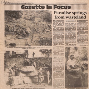 Whitehorse Historical Society Inc.
Newspaper - Article, Paradise springs from wasteland, 14/02/1990
A landscape designer was appointed in 1993 to prepare a master plan after which the mammoth task of clearing and planting was undertaken and koalas and sugar-gliders introduced. Information Centre built.parks and reserves, brandenburg, john p, yarran dheran, mullum mullum creek, smith, dorothy g., koalas, sugar gliders, schwerkolt, johann august