Showing 5786 items matching "location"
-
 Mission to Seafarers Victoria
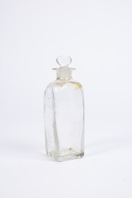
Container - Small Glass Container
Small glass container with a square base and an broken octagonal rim surrounding the circular opening on the top. Found within the front storage location of the parent item.volum collection -
 Glenelg Shire Council Cultural Collection
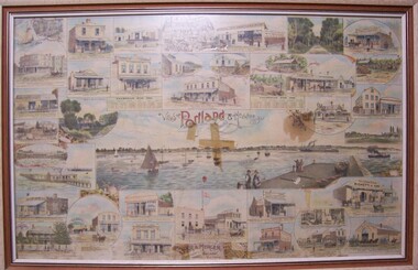
Print - Print - Views of Portland and Heywood, Victoria, Rider & Mercer, 1893
Owned by Elf Dusting, daughter of George Dusting. Dusting family early residents of Portland.Framed colour lithograph behind glass, depicting stores and locations in Portland and Heywood. Title in decorative letters in centre of page and name of printer at bottom centre.Front: (no inscriptions) Back: (no inscriptions)dustings family -
 4th/19th Prince of Wales's Light Horse Regiment Unit History Room
Photograph, 1914/18
A sepia toned photograph on card showing what could be an ammunition limber in the foreground and a cannon in the background which just fired. The location is flat open groundphoto, artillery -
 Ringwood and District Historical Society
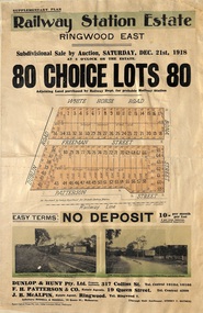
Flyer, Subdivisional Auction Sale Brochure, Railway Station Estate, Ringwood East, Vic. - 1918
Advertisement for subdivisional auction sale of 80 residential allotments on Saturday, 21st December, 1918, including terms of sale, subdivision layout, and nearby location photographs.Subdivision includes Mount Dandenong Road (incorrectly shown as White Horse Road), Dublin Road, Freeman Street, Bona Street, and Patterson Street. Local Agent - J.B. McAlpin, Telephone Ringwood 7. -
 Marysville & District Historical Society
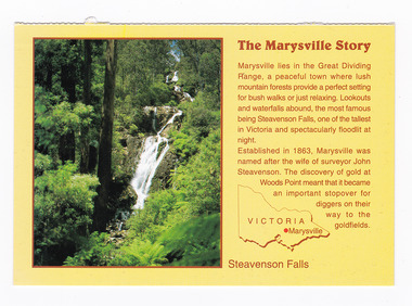
Postcard (item) - Colour postcard, Neil Cutts, The Marysville Story-Steavenson Falls, Pre 2009
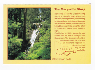
A postcard in a series produced by the Rose Stereograph Company in Victoria, Australia as a souvenir of Marysville.A colour photograph of Steavenson Falls in Marysville, Victoria. The Steavenson Falls is named after the Victorian Assistant Commissioner of Roads and Bridges, John Steavenson, who arrived in Victoria in the early 1860s. At 84 metres high, Steavenson Falls is Victoria's tallest cascading waterfall. The falls are split into roughly five cascades, with the last of these plunging into a small, picturesque rock pool. Rose Series Postcard No. 3530. The Marysville Story/ Marysville lies in the Great Dividing/ Range, a peaceful town where lush/ mountain forests provide a perfect setting/ for bush walks or just relaxing. Lookouts/ and waterfalls abound, the most famous/ being Steavenson Falls, one of the tallest/ in Victoria and spectacularly floodlit at/ night./ Established in 1863, Marysville was/ named after the wife of surveyor John/ Steavenson. The discovery of gold at/ Woods Point meant that it became/ an important stopover for/ diggers on their/ way to the/ goldfields. Steavenson Falls POST CARD The "Rose" Series/ De Luxe Proudly Printed in/ Australia Since 1880 AFFIX/ STAMP/HERE/ Rose Series/ Post Card No./ 3530 ADDRESS/ POSTCODE the MARYSVILLE STORY & Steavenson Falls/ MARYSVILLE, VICTORIA, AUSTRALIA/ Photo Neil Cutts Copyright Rose Stereograph Co., Glen Waverley, Victoria (03) 9560 7772marysville, steavenson falls, victoria, postcard, souvenir, rose stereograph co, 3530, john steavenson -
 Marysville & District Historical Society
Postcard (item) - Colour postcard, Neil Cutts, The Marysville Story-Steavenson Falls, Pre 2009
A postcard in a series produced by the Rose Stereograph Company in Victoria, Australia as a souvenir of Marysville.A colour photograph of Steavenson Falls in Marysville, Victoria. The Steavenson Falls is named after the Victorian Assistant Commissioner of Roads and Bridges, John Steavenson, who arrived in Victoria in the early 1860s. At 84 metres high, Steavenson Falls is Victoria's tallest cascading waterfall. The falls are split into roughly five cascades, with the last of these plunging into a small, picturesque rock pool. The Rose Series postcard No. 3530. The Marysville Story/ Marysville lies in the Great Dividing/ Range, a peaceful town where lush/ mountain forests provide a perfect setting/ for bush walks or just relaxing. Lookouts/ and waterfalls abound, the most famous/ being Steavenson Falls, one of the tallest/ in Victoria and spectacularly floodlit at/ night./ Established in 1863, Marysville was/ named after the wife of surveyor John/ Steavenson. The discovery of gold at/ Woods Point meant that it became/ an important stopover for/ diggers on their/ way to the/ goldfields. Steavenson Falls POST CARD The "Rose" Series/ De Luxe Proudly Printed in/ Australia Since 1880 AFFIX/ STAMP/HERE/ Rose Series/ Post Card No./ 3530 ADDRESS/ POSTCODE the MARYSVILLE STORY & Steavenson Falls/ MARYSVILLE, VICTORIA, AUSTRALIA/ Photo Neil Cutts Copyright Rose Stereograph Co., Glen Waverley, Victoria (03) 9560 7772marysville, steavenson falls, victoria, postcard, souvenir, rose stereograph co, 3530, john steavenson -
 Marysville & District Historical Society
Photograph (item) - Black and white photograph, 10-1947
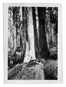
An early black and white photograph taken in the Cumberland Valley near Marysville in Victoria.An early black and white photograph taken in the Cumberland Valley near Marysville in Victoria. The Cumberland Valley is near Cambarville which was a timber town near Marysville. Cambarville is notable for its giant mountain ash (Eucalyptus regnans) trees within the Cumberland Memorial Scenic Reserve, and relics from former sawmills and gold mining. The Big Culvert is located nearby on the Marysville - Woods Point Road, which was historically part of the Yarra Track. Cambarville was established as a timber mill town in the 1940s. Timber mill owners A Cameron and FJ Barton named Cambarville. They established the mill to salvage timber from trees destroyed in the 1939 bushfires. Cambarville was impacted by the 2009 Black Saturday bushfires and any remaining structures were destroyed.Among Tall Timber at/ Cumberland Valley. Oct.47. 39cumberland valley, marysville, victoria, cumberland creek, mountain ash, timber mill, mining, a cameron, fj barton, cambarville, big culvert, yarra track, black saturday bushfires, 1939 bushfires, photograph -
 Bendigo Historical Society Inc.
Photograph - CASTLEMAINE GAS COMPANY COLLECTION: PHOTO PADDOCK, 20/07/1999
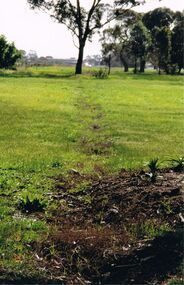
Photo of a paddock with what looks like the tracing of a trench. Trees in the background. At bottom left date stamp in yellow 20/07/1999. Location unknown.Kodakplace, land, paddock -
 Bendigo Historical Society Inc.
Photograph - CASTLEMAINE GAS COMPANY COLLECTION: PHOTO PEOPLE, 1987
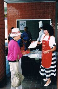
1987 Cooking school's competition - Lady in red apron handing a paper to an elderly lady, Chef cooking bbq, 2 males standing. Location Unknown.Kodakevent, entertainment, school's cooking competition -
 Bendigo Historical Society Inc.
Photograph - CASTLEMAINE GAS COMPANY COLLECTION: PHOTO PEOPLE
Gas and Fuel Fashion,Food,Fitness. Group on stage - 2 males 6 females in what looks like a fashion parade. Date and location unknownevent, social, gas & fuel fashion, food, fitness -
 Bendigo Historical Society Inc.
Photograph - CASTLEMAINE GAS COMPANY COLLECTION: PHOTO PEOPLE
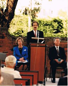
The Hon Marie Tehan MP sitting at left of unknown male standing delivering a speech, another unknown male sitting at right. Date and location unknown.Kodakperson, group, marie tehan mp -
Port Melbourne Historical & Preservation Society
Postcard - Princes Pier, Port Melbourne, 1880 - 1952
Collected by Alison KELLy when she was caretaking the Missions to Seamen Building 1987-90. Image taken- between 1948 and 1952 vessel on left is Shaw Savill's Doric. RAN vessel at right is cruiser Australia and carrier Melbourne in background. Note also that electrical overhead still standing on both sides of pier for trains (removed late 1952). Local shipping expert Glen STUART advised that the Pier was Princes Pier and not Station Pier as shownOne of four postcards of various locations in Port Melbourne. B&W postcard - (The Rose Series 4535) - Entrance to Princes Pier - not Station Pier as shown piers and wharves - railway pier, piers and wharves - princes pier, parks and gardens -
Port Melbourne Historical & Preservation Society
Photograph - Group of people looking at bottom halves of two cranes from Station Pier on land under West Gate Bridge, 2012
Coloured photograph of six (6) people and a child looking at bottom halves of two Station Pier cranes . Location is land under West Gate Bridge.west gate bridge, built environment - industrial, engineering, piers and wharves - station pier, cranes, margaret bride, glen cosham, jim power, graham bride -
Port Melbourne Historical & Preservation Society
Photograph - Port Melbourne light rail terminus, 2002
Further updates from Ron Laing's photograph collection of Port Melbourne.(4) colour photographs of the Port Melbourne tram terminus showing its location in relation to the old Port Melbourne railway station, now a medical centre.transport - tramways, ron laing -
Port Melbourne Historical & Preservation Society
Photograph - Various night/evening views, Port Melbourne, Ron Laing, 1990s
Part of Ron Laing's collection of photographs recording Port Melbourne over a thirteen year period. Donated to the PMH&PS by the photographer.One of a set of 35 colour photogaphs of evening and night shots taken at various locations in Port Melbourne Sunset behind clouds and docks infrastructure silhouettedron laing, sunset, docks infrastrutre -
Port Melbourne Historical & Preservation Society
Photograph - Various night/evening views, Port Melbourne. Bay Street, Ron Laing, 1990s
Part of Ron Laing's collection of photographs recording Port Melbourne over a thirteen year period. Donated to the PMH&PS by the photographer.One of a set of 35 colour photogaphs of evening and night shots taken at various locations in Port Melbourne. Bay street at night. Town Hall prominentbay street, ron laing, built environment - civic, port melbourne town hall -
Port Melbourne Historical & Preservation Society
Photograph - Various night/evening views, Port Melbourne. Albert street, Ron Laing, 1990s
Part of Ron Laing's collection of photographs recording Port Melbourne over a thirteen year period. Donated to the PMH&PS by the photographer.One of a set of 35 colour photogaphs of evening and night shots taken at various locations in Port Melbourne Nightime on Albert Street with all parking takenron laing, albert street -
Port Melbourne Historical & Preservation Society
Photograph - Princes Street, 1999
Ron photographed this at our request, matching the B&W photograph taken in 1933.Colour photograph of Princes Street taken by Ron Laing in 1999, looking south from same location as the 1933 shot (749, 799) of same view.built environment, ron laing, princes street -
 Port Melbourne Historical & Preservation Society
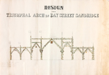
Plan - Triumphal Arch, Bay Street, Sandridge, Borough of Sandridge, 1867
Drawn for the Council Committee for reception of Prince Alfred Oct 1867Design for triumphal arches in Bay Street, Sandridge (with measurements for Fountain Inn, Bridge Street and Liardet Street locations) probably 1867 - visit of Prince AlfredMeasurements noted in pencil.royal visits and occasions, celebrations fetes and exhibitions, prince alfred, bay street -
 Port Melbourne Historical & Preservation Society
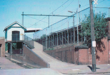
Photograph - Montague Railway Station, Glen Stuart, 1987
From set of nine colour photographs of various locations on the Port Melbourne Railway Line from Port Melbourne to Montague Stations, 1987: Montague Stationtransport - railways, glen stuart -
Port Melbourne Historical & Preservation Society
Photograph - Elgamolya, Wigglen Floating Dry Dock, 1990s
From set of four (4) photographs of ships in various locations in Port Melbourne. (.04) Eigamoiya, Cargo / Passenger ship, at Wigglen Floating Dry Docktransport - shipping, eigamoiya, wagglen floating dry dock -
 Port Melbourne Historical & Preservation Society
Document, Hotels in Port Melbourne
The letter on the outside of the sheet is from Jim (?) to Les (Turner). It gives some of his childhood recollections of Port Melbourne Hotels These include the Shamrock which he understood that it was "... a weatherboard Building - very Badly Conducted and when it was burned down it was not rebuilt... I did know that there was a murder there."Inside is hand drawn map of Port Melbourne with the hotels marked in position as well as a Key down the left hand side. The accompanying typed sheet lists the 50 original hotels on the left hand side and the 20 remaining on the right.A large ruled sheet of paper with a letter on the outside & inside a hand drawn map of Port Melbourne with the location of hotels marked. A typed sheet lists the hotels.Hotels of Port Melbourne. Originally there were 50. today there are 20.business and traders - hotels, shamrock hotel, leslie stanley turner -
 Bendigo Historical Society Inc.
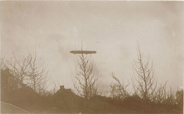
Postcard - ACC LOCK COLLECTION: SEPIA PHOTO OF A ZEPPELIN, POSTCARD, 1914-1918
Postcard, WW1, sepia photo of a zeppelin flying over some houses. Deciduous trees in foreground. Location unknown. G38 and GS handwritten in pencil on back.postcard, postcard, ww1, france, zeppelin -
 Bendigo Historical Society Inc.
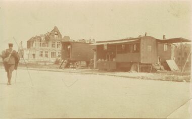
Postcard - ACC LOCK COLLECTION: SEPIA PHOTO OF CARAVANS AND BUILDING, POSTCARD, 1914-1918
Postcard, WW1, Sepia photo of two stationery wooden caravans with a damaged building to the left. Soldier at left walking away from camera. Location not known.postcard, ww1, france -
Clunes Museum
Card - BUSINESS CARD
WHITE BUSINESS CARD SIMPSON LE MESURIER FILMS JOHN BROUSEK - LOCATION MANAGER JA;OFAX F.P. PRODUCTION OFFICE CI.GTV CHANNEL NINEjohn brousek, simpson le mesurier films -
Clunes Museum
Newspaper - PAPER CUTTING, THE WEEKLY TIMES, 22/05/1915
4 PAGES OF THE WEEKLY TIMES. PHOTO OF THE 5TH BATTALION AND VARIOUS OTHER MILITARY PHOTOS IN DIFERENT LOCATIONS. A PHOTO OF A GOLDEN WEDDING CELEBRATION AT NORTH CLUNESlocal history, document, newspaper, military -
 Whitehorse Historical Society Inc.
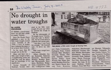
Article, Legacy is set in concrete No drought in water troughs, 2003
Two articles on Bills Water Troughs built across Victoria and elsewhere following the legacy of George Bills. Includes list of known locations including Blackburn.Two articles on Bills Water Troughs built across Victoria and elsewhere following the legacy of George Bills. Includes list of known locations including Blackburn.Two articles on Bills Water Troughs built across Victoria and elsewhere following the legacy of George Bills. Includes list of known locations including Blackburn.bills water troughs, bills, george -
Whitehorse Historical Society Inc.
Map, Tunstall 1945, 1945
A map drawn from memory about 20 years ago by Colin Fraser of the businesses and residents of Tunstall, 1945, including the location of Fraser General Store.A map drawn from memory about 20 years ago by Colin Fraser of the businesses and residents of Tunstall, 1945, including the location of Fraser General Store.A map drawn from memory about 20 years ago by Colin Fraser of the businesses and residents of Tunstall, 1945, including the location of Fraser General Store.tunstall, tunstall railway station, tunstall avenue nunawading, tunstall state school no 4190, fraser, colin -
 Whitehorse Historical Society Inc.
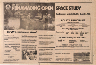
Newspaper - Article, City of Nunawading open space study, 27/11/1985
Policy principles for providing open space including range of categories, locations and developments. Efficiency and effectiveness of open space and fostering of recreational developments to be taken into consideration.local government, city of nunawading, reserve development fund, parks and reserves -
 Whitehorse Historical Society Inc.
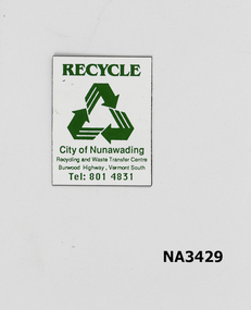
Domestic object - Fridge magnet
White plastic with green printing of logo and 'Recycle, City of Nunawading'. Location of Vermont South Recycle and Waste Transfer Centre and its telephone number given.domestic items, ornaments / decorative