Showing 8319 items
matching mckillops-bridge
-
 Eltham District Historical Society Inc
Slide - Photograph, New Lower Plenty Bridge, c.Sep. 1989
Part of a slide show presentation "Bridges & Waterways of the Shire" by Russell Yeoman to the 13 September 1989 Society meeting. The presentation included slides of historic photos from the Shire of Eltham Pioneers collections as well as several recent views.35mm colour positive transparency (1 of 15) Mount - Agfa CS System grey 8 dotslower plenty bridge -
 Eltham District Historical Society Inc
Slide - Photograph, Brougham Street Bridge, Eltham, c.Sep. 1989
Part of a slide show presentation "Bridges & Waterways of the Shire" by Russell Yeoman to the 13 September 1989 Society meeting. The presentation included slides of historic photos from the Shire of Eltham Pioneers collections as well as several recent views.35mm colour positive transparency (1 of 15) Mount - Agfa CS System grey 8 dotsbrougham street bridge, eltham -
 Eltham District Historical Society Inc
Slide - Photograph, Footbridge, Bridge Street, Eltham, c.Sep. 1989
Part of a slide show presentation "Bridges & Waterways of the Shire" by Russell Yeoman to the 13 September 1989 Society meeting. The presentation included slides of historic photos from the Shire of Eltham Pioneers collections as well as several recent views.35mm colour positive transparency (1 of 15) Mount - Agfa CS System grey 8 dotseltham, footbridge, bridge street -
 Eltham District Historical Society Inc
Slide - Photograph, Oxley Bridge, Henley Road, Kangaroo Ground, c.Sep. 1989
Part of a slide show presentation "Bridges & Waterways of the Shire" by Russell Yeoman to the 13 September 1989 Society meeting. The presentation included slides of historic photos from the Shire of Eltham Pioneers collections as well as several recent views.35mm colour positive transparency (1 of 15) Mount - Agfa CS System grey 8 dotsoxley bridge, henley road, kangaroo ground -
 Eltham District Historical Society Inc
Slide - Photograph, Aqueduct Bridge, Nicholas Lane, Kangaroo Ground, c.Sep. 1989
Part of a slide show presentation "Bridges & Waterways of the Shire" by Russell Yeoman to the 13 September 1989 Society meeting. The presentation included slides of historic photos from the Shire of Eltham Pioneers collections as well as several recent views.35mm colour positive transparency (1 of 15) Mount - Agfa CS System grey 8 dotskangaroo ground, aqueduct bridge, nicholas lane -
 Eltham District Historical Society Inc
Slide - Photograph, Lintons Bridge, Nutfield, c.Sep. 1989
Part of a slide show presentation "Bridges & Waterways of the Shire" by Russell Yeoman to the 13 September 1989 Society meeting. The presentation included slides of historic photos from the Shire of Eltham Pioneers collections as well as several recent views.35mm colour positive transparency (1 of 15) Mount - Agfa CS System grey 8 dotslintons bridge, nutfield -
 Bendigo Military Museum
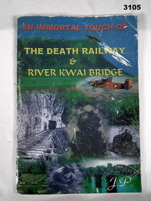
Book - BOOK, POW’S, Organised by JP, The Death Railway & River Kwai Bridge
Book details the construction of the Thai Burma Railway & the bridge over the Rivew Kwai. Contains detailed photos & drawings. Taken from an oration by Fred Seiker in which he recalls the conditions under which the POW's lived & worked.Soft cover illustrated front & back with colour & black & white photos. 60 pages with cut edges. Bound with staples. Stamped inside front & back covers: Bendigo District RSL Sub Branch books-military-history, civil engineering/railways, river kwai, burma -
 Greensborough Historical Society
Photograph - Digital Image, Bridge Inn Hotel Mernda 2018, 25/07/2019
In 2018 GHS members visited Turner's Bakery in Mernda for lunch and continued on to visit historic sites remaining in the Mernda area. This photograph shows the Bridge Inn Hotel Mernda, established 1891. The hotel is still operating in the 21st century.Mernda is an area of rapid modern growth with a few remaining historic buildings dating from the 19th century.Digital copy of colour photographmernda, bridge inn hotel mernda, mernda historic sites, hotels mernda -
 Eltham District Historical Society Inc
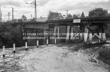
Photograph - Negative, Russell Yeoman, Railway Bridge across Plenty River near Railway Road, Briar Hill, Vic, c.1970
Part of a slide show presentation "Bridges & Waterways of the Shire" by Russell Yeoman to the 13 September 1989 Society meeting. The presentation included slides of historic photos from the Shire of Eltham Pioneers collections as well as several recent views.Roll of 35mm black and white negative film, 4 of 7 stripsIlford HP4bridge, greensborough, para road, plenty river, railway bridge -
 Ringwood and District Historical Society
Envelope, Packet: Ringwood Area Hotels - Coach and Horses, Empress India, Burnt Bridge. Also Antimony Mine Hotel Proclaimed 1878
Hotels list; Coach and Horses Hotel; Club Hotel Sept-1887 Wiggin sold to Lindsey; Empress India Hotel; Antimony Mine Hotel, East Ringwood, Cnr Main & Pratt St proclaimed 21-Jan-1878 owing to increase in mining population, 4 licences in locality; Burnt Bridge Hotel; "Duke of York" -
 Melbourne Tram Museum
Document - Research Notes, H. S. McComb, Details of Richmond line - Spencer St, Flinders St and Bridge Road, c1930
Notes, 9 pages, has been pinned together, giving details, opening dates, terminals, depot entries, sheave pits, curves, for the Richmond line - Spencer St, Flinders St and Bridge Road. Items 2064 to 2075 within box 72.3 in a brown folder marked "MT&O Co." red pencil on the front cover.trams, tramways, mto co, cable trams, drawings, reports, surveys, richmond, spencer st, flinders st, bridge rd -
 Melbourne Tram Museum
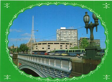
Postcard, Biscay Greetings, Princes Bridge from Batman Ave, mid to late 1980's
Colour postcard divided back - Biscay Greetings, series of featuring Princes Bridge from Batman Ave with the Arts Centre in the background. Image contained within a decorative oval. Back has space for name and address, stamp and a message and details of the postcard. Produced by Biscay Greetings, possibly mid to late 1980's. Card No. BG216trams, tramways, princes bridge -
 Greensborough Historical Society
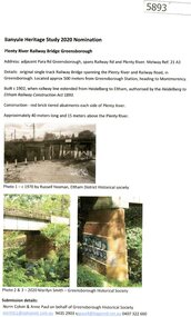
Document - Submission, Norm Colvin et al, Banyule Heritage Study 2020 Nominations - Plenty River railway bridge Greensborough, 2020
Part of the single track railway extension of 1902 from Heidelberg to Eltham, the Plenty River railway bridge Greensborough, was nominated for the Banyule Heritage Study 2020. This nomination was prepared by Norm Colvin & Anne Paul on behalf of the Greensborough Historical Society1 p. Text and photographshurstbridge rail line, plenty river, banyule heritage study 2020 -
 Eltham District Historical Society Inc
Photograph, Main Road Bridge, Eltham, c.1924
The wooden Main Road Bridge was substantially damaged in the 1924 flood and was replaced with a concrete structure Pages from a scrapbook belonging to Heather Jenkins (nee Sargeant) who lived as a child in the Police Residence at 728 Main Road, Eltham in the 1920s.This photo shows the flood damage to the bridge structure or the dismantling of the bridge post 1924 flood. Heather Sargeant was the daughter of Constable W.C. Sargeant, the local police officer in residence at Eltham, 1922-1927Glued on a brown paper scrapbook page (torn from scrapbook) with 9 black and white/sepia photos of varying sizes, 1 newspaper clipping and handwritten captions in ink.On verso in pencil "Const. W.C. Sargeant 1922-1927 - see Police list"heather jenkins (nee sargeant), eltham, police residence, constable w.c. sargeant, main road, main road bridge -
 Stawell Historical Society Inc
Photograph, Frampton’s Bridge in Joel Joel where the heavy tractor that Mr Slorach was driving broke through the wooden planks
Frampton’s Bridge Joel Joel. Accident occurred while Mr Arch Slorach was crossing. The heavy tractor broke through the wooden planks. Mr Slorach who as a result of War injuries had a wooden leg was able to jump clear.shire, frampton's bridge -
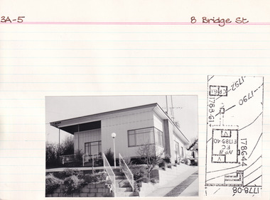 The Beechworth Burke Museum Research Collection
Card (Series) - Index Card, George Tibbits, 8 Bridge Road, Beechworth, 1976
George Tibbits, University of Melbourne. Faculty of Architecture, Building and Town & Regional PlanningIndex system that support the research for Beechworth : historical reconstruction / [by] George Tibbits ... [et al]Arranged by street names of BeechworthEach index card includes: street name and number of property, image of property, allotment and section number, property owners and dates of ownership, description of the property according to rate records, property floor plan with dimensions.beechworth, george tibbitsbeechworth, george tibbits -
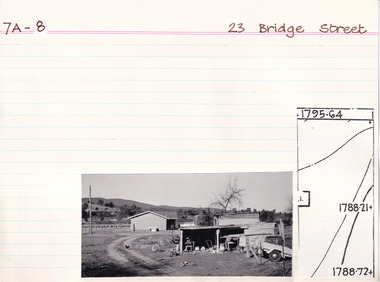 The Beechworth Burke Museum Research Collection
Card (Series) - Index Card, George Tibbits, 23 Bridge Street, Beechworth, 1976
George Tibbits, University of Melbourne. Faculty of Architecture, Building and Town & Regional PlanningIndex system that support the research for Beechworth : historical reconstruction / [by] George Tibbits ... [et al]Arranged by street names of BeechworthEach index card includes: street name and number of property, image of property, allotment and section number, property owners and dates of ownership, description of the property according to rate records, property floor plan with dimensions.beechworth, george tibbitsbeechworth, george tibbits -
 The Beechworth Burke Museum Research Collection
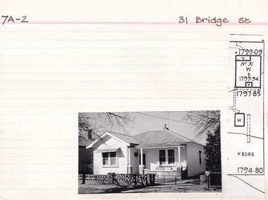
Card (Series) - Index Card, George Tibbits, 31 Bridge Street, Beechworth, 1976
George Tibbits, University of Melbourne. Faculty of Architecture, Building and Town & Regional PlanningIndex system that support the research for Beechworth : historical reconstruction / [by] George Tibbits ... [et al]Arranged by street names of BeechworthEach index card includes: street name and number of property, image of property, allotment and section number, property owners and dates of ownership, description of the property according to rate records, property floor plan with dimensions.beechworth, george tibbitsbeechworth, george tibbits -
 The Beechworth Burke Museum Research Collection
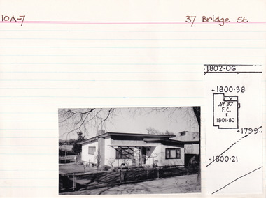
Card (Series) - Index Card, George Tibbits, 37 Bridge Street, Beechworth, 1976
George Tibbits, University of Melbourne. Faculty of Architecture, Building and Town & Regional PlanningIndex system that support the research for Beechworth : historical reconstruction / [by] George Tibbits ... [et al]Arranged by street names of BeechworthEach index card includes: street name and number of property, image of property, allotment and section number, property owners and dates of ownership, description of the property according to rate records, property floor plan with dimensions.beechworth, george tibbitsbeechworth, george tibbits -
 The Beechworth Burke Museum Research Collection
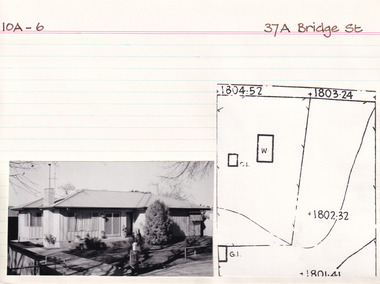
Card (Series) - Index Card, George Tibbits, 37A Bridge Street, Beechworth, 1976
George Tibbits, University of Melbourne. Faculty of Architecture, Building and Town & Regional PlanningIndex system that support the research for Beechworth : historical reconstruction / [by] George Tibbits ... [et al]Arranged by street names of BeechworthEach index card includes: street name and number of property, image of property, allotment and section number, property owners and dates of ownership, description of the property according to rate records, property floor plan with dimensions.beechworth, george tibbitsbeechworth, george tibbits -
 The Beechworth Burke Museum Research Collection
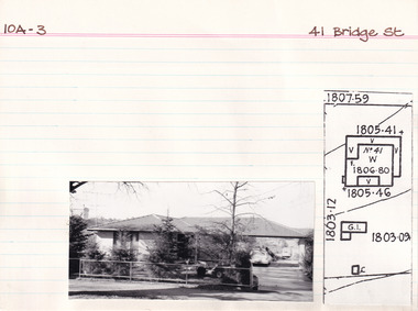
Card (Series) - Index Card, George Tibbits, 41 Bridge Street, Beechworth, 1976
George Tibbits, University of Melbourne. Faculty of Architecture, Building and Town & Regional PlanningIndex system that support the research for Beechworth : historical reconstruction / [by] George Tibbits ... [et al]Arranged by street names of BeechworthEach index card includes: street name and number of property, image of property, allotment and section number, property owners and dates of ownership, description of the property according to rate records, property floor plan with dimensions.beechworth, george tibbitsbeechworth, george tibbits -
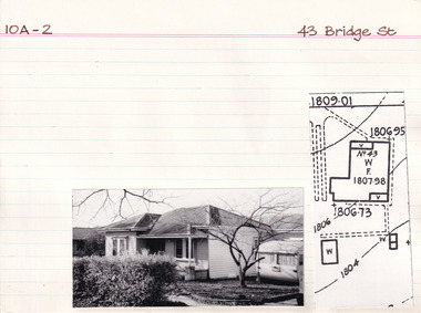 The Beechworth Burke Museum Research Collection
Card - Index Card, George Tibbits, 43 Bridge Street, Beechworth, 1976
Property - 43 Bridge Street, Beechworth - Section 10A, Town Allotment 2 - 100' x 440' Ownership details and history - 6 Jan 1871 - J. Reeve Architectural Index Card - Brian Pump and Tony Dugan - Photographers beechworth, george tibbits -
 Kiewa Valley Historical Society
Photo Framed - Broken Bridge, c1940's
The Tawonga Bridge over the East Kiewa River linked Mt Beauty with Tawonga. It was broken during Vera Hore's lifetime, 1909 - 2000. The bridge over the East Kiewa River enabled people to travel between Mt Beauty and Tawonga. Vera Hore (nee Ryder), the publican of the Tawonga Hotel, took this photo as she was a keen amateur photographer. Vera lived from Nov. 1909 to July 2000.Colored photo of 'Broken Bridge' over the East Kiewa River on Damm's Road with Mt Bogong, with snow, in the background of centre top. Framed with 2 cm wide cream cardboard surrounded by a metal decorated frame. The back has a flap for displaying the photo on a bench or table. On the back, a white sticker inscribed:- "Broken Bridge" / Old Timber Bridge / over East Kiewa River / on Damm's Rd." On the back top left corner hand written:- "Vera Hore"tawonga bridge; vera hore; east kiewa river; tawonga hotel -
 Eltham District Historical Society Inc
Photograph - Colour Print, Lewis Tulk, Bridge Street, Eltham District Scout Camp, Eltham Town Park, c.1982
View looking southeast from Eltham Town Park (present-day Al;istair Knox Park) across Bridge Street towards the new Eltham Community Centre. Donated by Lewis Tulk, former Scout Area Training Commisioner for Leaders.scouts victoria, scout leader training, lewis tulk collection, yarra batman area, alistair knox park, bridge street, eltham community centre, eltham district scout camp, eltham town park -
 Eltham District Historical Society Inc
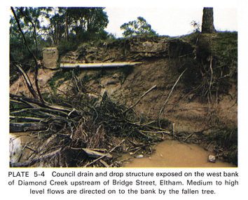
Work on paper (Sub-Item) - Photograph, Council drain and drop structure exposed on the west bank of Diamond Creek upstream of Bridge Street, Eltham
Colour photograph of a muddy creek (probably after a downpour) showing council drain and drop structure exposed on the west bank of Diamond Creek upstream of Bridge Street, Eltham. Mediun to high level water flows are directed on to the bank by the fallen tree.eltham, creek, diamond creek, bridge street, drainage, waterflow, vegetation -
 Greensborough Historical Society
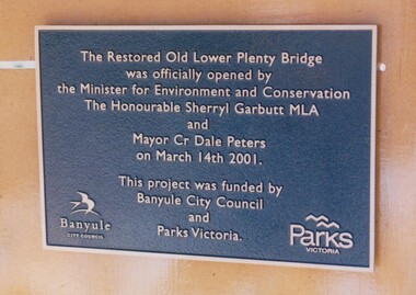
Photograph - Digital Image, Anne Paul, Plaque: Opening of restored Old Lower Plenty Bridge 2001, 14/03/2001
This plaque commemorates the opening of the restored Old Lower Plenty Bridge, opened on 14/03/2001 by the Minister for Environment and Conservation Sherryl Garbutt MLA and Mayor of Banyule Cr Dale Peters. The project was jointly funded by Banyule Council and Parks Victoria.Digital copy of colour photograph of memorial plaquelower plenty, lower plenty bridge, sherryl garbutt, dale peters, banyule council, parks victoria -
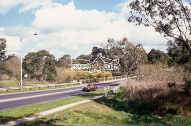
 Eltham District Historical Society Inc
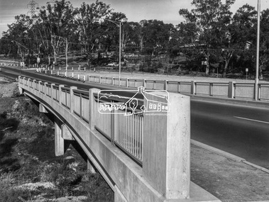
Photograph, Shire of Eltham, New bridge over the Plenty River, Lower Plenty, Nov. 1966
Newly constructed single span bridge on Main Road (now Lower Plenty Road) crossing the Plenty River at Lower Plenty. Site of Heidelberg Golf Club and Lower Plenty Hotel in the background. This was the boundary between the Shire of Eltham and the City of Heidelberg.This photo forms part of a collection of photographs gathered by the Shire of Eltham for their centenary project book ,"Pioneers and Painters: 100 years of the Shire of Eltham" by Alan Marshall (1971). The collection of over 500 images is held in partnership between Eltham District Historical Society and Yarra Plenty Regional Library (Eltham Library) and is now formally known as 'The Shire of Eltham Pioneers Photograph Collection.' It is significant in being the first community sourced collection representing the places and people of the Shire's first one hundred years.Digital imagesepp, shire of eltham pioneers photograph collection, lower plenty, bridge -
 Kew Historical Society Inc
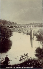
Postcard, River Yarra near Macauleys' Boathouse Kew, c.1910
The Pipe Bridge was constructed to bring fresh water from Fairfield to Kew. This bridge was destroyed in the 1934 Flood and later reconstructed.Early sepia real photo postcard of the first Pipe Bridge bringing water from the Yan Yean Reservoir to Kew. The site is upriver of the original Macauley's boathouse. Obverse: "River Yarra near Macauleys' Boat House Kew". Reverse: "(Pipe Water Line) / Kew to Fairfield above boat house / Pipe Bridge / Received from L. Bennett 1980".bridges - kew (vic.), bridges - yarra river -- kew (vic.), pipe bridge -
 Phillip Island and District Historical Society Inc.
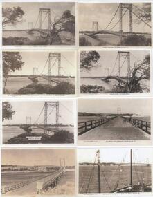
Photograph - Post Cards, Photo Shop Series et al, Early 20th Century
One of 15 A3 pages with copies of Postcards on each. From the Shirley Jones Collection.Copies of Postcards. All photos of the Phillip Island Suspension Bridge.Left side from top to bottom: "Photo Shop Series - Phillip Island Bridge"; "The Rose Series P4304 - View of Suspension Bridge San Remo - Phillip Island"; "Suspension Bridge - Phillip Island"; "The Suspension Bridge - San Remo". Right side from top to bottom: "Murray Views No 5 - The Bridge San Remo Vic"; "Photo Shop Series No. 4 - Phillip Island San Remo Bridge"; "The Rose Series P1967 - The Bridge from Newhaven Phillip Island Vic"; "The Rose Series P4227 - The Bridge from Jetty Newhaven Phillip Island".phillip island suspension bridge, shirley jones collection, thelma astbury -
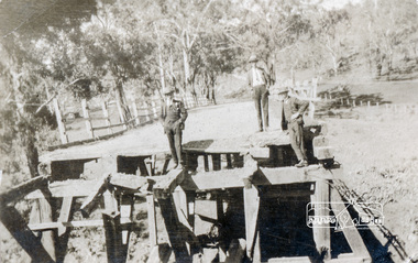
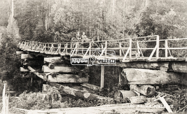 Eltham District Historical Society Inc
Negative - Photograph, Log bridge over Pheasant Creek, Kinglake, c.1920
Reproduced on p74 of 'Pioneers & Painters' Driver is Mr. F. Thomson, brother of Mrs McMinn. The timber tramway bridge was built by Mr. Munro, owner of the saw mill. The wooden tram rail ran from the timber logging site to saw mill to Whittlesea.Roll of medium format 120 6x6 black and white negative film, 4 framesAgfa APX 100shire of eltham pioneers photograph collection, bridge, f. thomson, kinglake, log bridge, mr. munro, pheasant creek, pioneers and painters, timber tramway