Showing 2319 items matching "parishes"
-
 Bendigo Historical Society Inc.
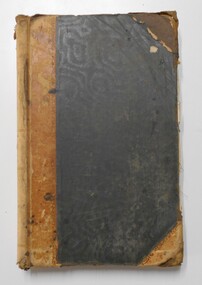
Document - LANDS OFFICE: DISTRICT SURVEYORS SANDHURST INDEX OF PLANS, no date probably 19C
Document: dark green hard cover journal with buff spine and corners. Index in front A - Z. 400 pages, pages not indexed but numbered. Index lists places of various districts e.g. Bridgewater on page 7. Plan details give allotments, parish, sections, plan number.Lands Officelands office, index of plans, plans, bendigo -
 Warrnambool and District Historical Society Inc.
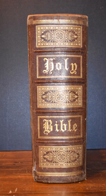
Book - Bible, Thomas Bankes, The Christian's New and Complete Family Bible, 1786
This is a family bible circa late 1700'sThe book has a plain brown leather cover, the front of which is scuffed, stained and completely detached from the spine. On the spine is printed Bankes's Bible, an alternative title. The pages contain text, black and white plates, images and engravings. Some of the pages are torn, others have been repaired with paste. The dedication by Thomas Bankes, a clergyman, is to his Bishop Lord James Beauclerc. All the 's' letters are written as ' f'.non-fictionThis is a family bible circa late 1700's18th century literature, family bible, 1786 bible, warrnambool -
 Eltham District Historical Society Inc
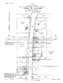
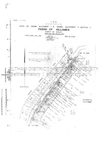
Document - Survey Plan, Country Roads Board, SP 6800, Eltham-Yarra Glen Road; Bridge St to Henry St, 1958
1958 C.R.B. Plan of Survey of Part of Crown Portions 12 and 13 Section 4 Parish of Nillumbik, County of Evelyn Eltham-Yarra Glen Road., Shire of Eltham Shows Surveyor field notes, property ownership and building type and construction.1958, a.m. gahan, a.s & s.j. davis, annie ellen davies, bridge street, country roads board, d.a. lyon, dave lyon, eltham, flora towell, g.e. gallagher, henry street, j. lyon, k. greene, main road, p.a. gahan, survey plan, w.l. chynoweth pty ltd, york street, neil webster collection -
 Eltham District Historical Society Inc
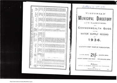
Folder, Victorian Municipal Directory and Gazetteer: and also Commonwealth Guide and the water Supply records for 1936, 1936
Includes municipal information about the Shire including brief history, parishes, political boundaries and names of representatives, statistics, Councilors, Officers, names of places and descriptions. Also includes part one for Euroa Shire and last page for Shire of East Lodden.3 pages. Photocopy relating to Eltham Shire. Includes title page and pages 568-571.HG Booklet 25harry gilham collection, councilors, directory, towns, 1936, shire of eltham -
 Federation University Historical Collection
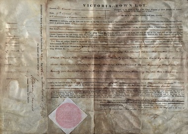
Document, Grant, by Purchase, Ballarat, Victoria, 1856, 1856
Thomas Bath of Ballarat became the purchaser of a parcel of land for the sum of Five Hundred Pounds. The land was in the County of Grant, Parish of Ballarat. Record of Register of Town Purchase, No. 50, Page 156 on 20 April 1856 and signed by William C Haines.Thick cream paper, badly stained. Hanad written Official seal Dated 9 April 1856 Signed: E Macarthur - Major General Edward Macarthur Signed: William C Haines - Colonial Secretarythomas bath, county of grant, parish of ballarat, william c haines, colonial secretary, edward macarthur -
 St Kilda Historical Society
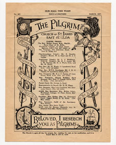
Document - Newsletter, The Pilgrim, 1957
Newsletter of the Church of St James East, St Kilda, edition no 367, published in March 1957. Contains the names of the Parish Priest and church officials; the dates and times of services, including for Lent 1957; lists of new subscribers; summaries of meetings; announcements.White paper, yellowed with age, printed in black on both sides and folded in half.the pilgrim newsletter, church of st james - east st kilda -
 Melbourne Tram Museum
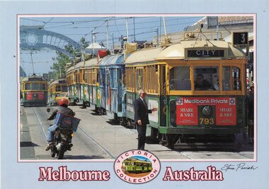
Postcard, Steve Parish Paddington Qld, Prince's Bridge, late 1980's
Colour postcard grey border, divided back - Steve Parish postcard of 7 trams on Prince's Bridge, with a blue arch in the background. The lead tram - W5 or SW5 793 showing route 3, followed by many trams. On the other track appears to be SW5 872, route 15. Both have Medibank Private adverts on the front. May have been at the time of an event, given that a Officer in a suit is talking to the driver. Back has space for name and address, stamp and a message and details of the postcard. Produced by Steve Parish Postcards. Card No. PC3029 and a historical note regarding trams on the back. Has "Melbourne Australia" along the bottom edge.trams, tramways, princes bridge, sw5 class, route 3, route 15, tram 793, tram 872? -
 Mission to Seafarers Victoria
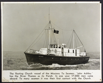
Photograph - Mounted photograph, Black and white, Floating church vessel the "John Ashley"
large rectangular heavy card b/w photograph in landscape format. Photo includes printed description as part of photo.Description printed beneath actual photo on front: "The floating church vessel of the Missions To Seamen, "John Ashley," has the river Thames as its Parish. In one year 17,000 men came aboard. To many seamen it was their first contact with the Church."reverend john ashley (1801-1886), floating church, mission to seamen, river thames, england -
 Kew Historical Society Inc
Plan - Subdivision Plan, J R Mathers & McMillan, Myrtle Hill Estate, East Kew, circa 1949, c.1949
The Kew Historical Society's map collection includes a substantial number of real estate subdivision plans, mainly of Kew but also of surrounding suburbs in Melbourne. Most of the subdivision plans date from the 1920s and 1930s when the districts old homes and local farmland were being split up to accommodate residential growth in the postwar period. These early plans were assembled by a local firm, Jas R Mather & McMillan, which had an office in Cotham Road. Many of the plans, and sometimes photos, were annotated by the agents.Subdivision plans are historically important documents used as evidence for the growth of suburbs in Australia. They frequently provide information about when the land was sold as well as evidence relating to surveyors and real estate and financial agents. The numerous subdivision plans in the Kew Historical Society's collection represent working documents, ranging from the initial sketches made in planning a subdivision to printed plans on which auctioneers or agents listed the prices for which individual lots were sold. In a number of cases, the reverse of a subdivision plan in the collection includes a photograph of a house that was also for sale by the agent. These photographs provide significant heritage information relating house design and decoration, fencing and household gardens.The photograph may also be aesthetically significant depending on the importance of the photographic atelier.Myrtle Hill, at 14 Vista Avenue, Kew, is of local historical and architectural significance as a good example of a large and imposing single-storey Italianate house of the early 1870s surviving in Kew. Originally sited on a large allotment overlooking Normanby Road, the setting of the house has been dramatically altered through extensive subdivision and development. The subdivision plan of the ‘Myrtle Hill Estate’ indicates that in one such subdivision, 11 allotments were created fronting Bowyer Avenue, Myrtle Avenue, and Normanby Road. The outline and building profile of Myrtle Hill is shown on the west side of Bowyer Avenue.The full (typed) title of this subdivision plan is :"Plan of SUBDIVISION of part of CROWN PORTION 83. / at KEW / PARISH OF BOROONDARA. / COUNTY OF BOURKE". / "MYRTLE HILL ESTATE / EAST KEW" In addition to the Title and subtitle, the plan also lists the advantages of the subdivision. -
 Ringwood and District Historical Society
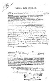
Land Purchase Document, Land Purchase for Samuel George Isaacs of Elizabeth Street, Melbourne for 148 acres, 2 roods and 9 perches in County of Mornington Parish of Ringwood - 1858, Feb-1858
1598 laminated copy on cardboard of Victoria - Land Purchase for Samuel George Isaacs of Elizabeth Street, Melbourne for 148 acres, 2 roods and 9 perches in County of Mornington Parish of Ringwood for the sum of 148 pounds 11 shillings and two pence. +Additional Keywords: Isaacs, Samuel Georgeas above -
 Ringwood and District Historical Society
Document, Certificate of Title and miscellaneous property records - Carter Real Estate, 122 and 124-128 Maroondah Highway, Ringwood, Victoria
Transfer of Land Act Title dated 24/4/2002 - Volume 10314 Folio 972 Crown Allotments 11H and 11J, Parish of Ringwood, Entitlement Grant to a depth of fifteen metres - 29/1/1997, City of Ringwood planning permit and diagram of office floor plan - 1973. -
 Federation University Historical Collection
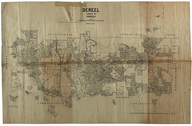
Plan, Dereel Parish Plan, 1928, 16/07/1928
Parish Plan of Dereel showing crown allotments, dimensions, crown grantees, dates of grant. Scale 1:31,680 WGS 84 Centroid 37 degrees 48 feet 33 inches S 143 degrees 41 feet 46 inches S NS: 6.3km EW: 15.2kmdereel, parish plan, p. mclachlan, rifle range, j. bower, dereel lagoon, t. mellington, j. mcdonald -
 Bendigo Historical Society Inc.
Map - CAMPBELL COLLECTION: BENDIGO AND DISTRICT MAPS, 2-2-29
Map. Wellsford, Parishes of Wellsford and Axedale, Scale 20 chains to 1 inch. Total area 4994 acres. Prepared in W.P.B. from A and P Plans, by W.J.G.2-2-29. Top left of map are directions to Fosterville, Huntly & Bendigo. (number 361 in map cupboard 1)W.J.Galbraithmap, bendigo, parish plan -
 Bendigo Historical Society Inc.
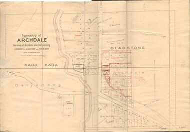
Map - JACK FLYNN COLLECTION: TOWNSHIP OF ARCHDALE, /08/1904
Map: Township of Archdale, Parishes of Archdale and Dalyenong, Counties of Gladstone and Kara Kara. Scale 4 Chains to 1 Inch. Has attached letters relating to land transfers between the Estate of Kate Sanderson and Barry Frederick Mortlock also between Matilda Jane Sanderson and A. O. Proctor.J. K. Spark Narrister & Solicitor, Formerly Mitchell, Monotti & Sparkmap, gladstone, township, archdale, dalyenong, gladstone, kara kara -
Whitehorse Historical Society Inc.
Newspaper - Article, Anglican Diocese of Melbourne
Article from the Anglican Diocese of Melbourne newspaper: 'See'. St John's, Blackburn Parish Hall is renovated for use of the Victorian Headquarters of the Church Missionary Society. The cottage in the church grounds has been renovated to serve the congregation. Rev Jessop dedicated St John's cottage at the end of February.st johns anglican church, blackburn, churches, blackburn, church missionary society, jessop, john (rev) -
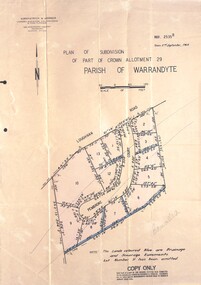 Ringwood and District Historical Society
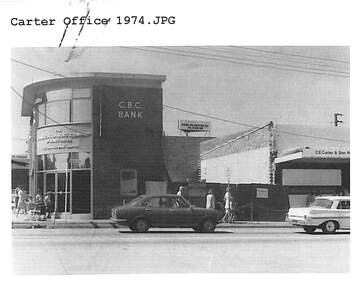
Document - Folder, Pembroke Estate Subdivsion, Ringwood, Victoria - 1964
Manilla folder containing certified copy of Plan of Subdivision dated 2nd September, 1964 - Part of Crown Allotment 29 Parish of Warrandyte, and separate A4 size copy of plan with handwritten 1966 pricing notations. Subdivision includes allotments on Pembroke Court off Loughnans Road, Ringwood.Surveyors - Kirkpatrick & Webber, Civil Engineers & Town Planners, 225 Maroondah Highway, Ringwood, Telephone 8700321. Agents - C.E. Carter & Son RESI., 126 Whitehorse Road, Ringwood (Phone) 87-6024, 87-6830, 870-2519. Folder covernote by Richard Carter - Carter Real Estate - "Vendor - Dale, Plan of Subdivision 68868, sold 23 July 1966." -
 Bacchus Marsh & District Historical Society
Map, Plan of Survey of Part of Crown Allotment 9, Parish of Korkuperrimul, 1890
This map documents a transfer of an allotment of land in Clarke Street Bacchus Marsh in 1890. Clarke Street is located on the eastern side of Bacchus Marsh not far from Main Street and Crook Street. It is now known as Candeloro Street. The map indicates J. Booth as the owner of the land and H. Simpson as the occupier. Next to this allotment is a an allotment of land owned by J. Elmore,Single page map showing Crown allotment 9, Parish of Korkuperrimul, County of Bourke. Scale 100 feet to inch. Part of a set of maps which are pasted into a bound volume containing 76 maps or plans in total. High resolution digital image stored on BMDHS computer network. At bottom of map: I hereby certify that I have made this survey expressly for the purpose of an application under the Transfer of Land Statute that this plan is correct. Barry B???, Lic. Surveyor, 16.10.90bacchus marsh victoria maps, clarke street bacchus marsh maps -
Glen Eira Historical Society
Book - St Peter's Catholic Church, Bentleigh East
The Golden Harvest Is A Book That Continues The History Of St Peter’s Parish, Bentleigh East From 1984 – 2005. The Book Discusses Community Life For The Previous 25 Years, Specifically Outreach And Services, Liturgy, Faith Education, And Fundraising, Finishing With Recollections From Parishioners.heriot maurice fr, mckenna fred fr, wade terry fr, gebbie gordon fr, casey william fr, maloney des fr, o’sullivan fr, guiney john, upton john stephen, kennedy james, o’ meara noreen sr, coakley daniel fr, chevalier wilma, sierakowski michael fr, centre road, bentleigh east, bignell road, opal court, the lighthouse project, mckenna centre, memorial stone, the anchor, bayside learning, memorial garden and wall, st peter's school, presentation sisters, daughters of our lady of the sacred heart, casey reserve, outside school hours program, moorleigh community centre, st james college, st james college chapel, loganville hostel, loganville social committee, the beacon, moongala drop-in centre, berlin wall souvenir, st peter's memorial book, faith and life development, altar servers, deaneries, bentleigh, chadstone, clayton, bentleigh east, moorabbin east, murrumbeena, oakleigh, ormond, clayton south, liturgy group, friday mass, sacramental sponsoring, sunday school, baptism support, children liturgy of the word, pre marriage program, cancer support group, ministry to the sick, loss and grief support, junior youth support, senior youth support, outreach, bingo, the parish fete, white elephant, young vinnies, st vincent de paul, spirituality in the pub (s.i.p), the passionist family group movement, rite of christian initiation for adults (r.c.i.a), prayer around the cross, st peter's prayer group, st peter's choir, antioch, catholic war veterans association, memorial bursary fund, catechetics, st peter's catholic church -
Glen Eira Historical Society
Document - St. Anthony’s Roman Catholic Church, Glen Huntly
One item on St. Anthony’s Roman Catholic Church, Glen Huntly: 1/A Carbon copy article mentions when church was officially opened, the parish priest, and the name of the first child christened there. Author Kathleen Meehan dated 09/10/1978.st. anthony’s church, glen huntly, glenhuntly, murphy anthony stanislaus, meehan kathleen, foundation stones, clergy, baptisms, official events, catholic church, catholic school, grange road, st. anthony’s primary school, hardman helen, principals -
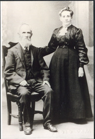 City of Moorabbin Historical Society (Operating the Box Cottage Museum)
Photograph, Francis Box 1836 -1912 and Eliza Jane Box(Thompson) c1900, c1900
Francis Box 1836 1912 migrated, from Sussex England 1855, with his father George Box b1808, and joined his brother William Box in the Parish of Moorabbin . he established a market garden and with Eliza Jane Box raised his familyFrancis Box was a member of the pioneer family who migrated from Sussex England 1955 and established market gardens in the parish of Moorabbin, County of Bourke.Black & White photograph of Francis Box 1836-1912 who married Eliza Jane Box in 1871 box george b 1808, box francis 1836- 1912, box eliza jane , box william, box elizabeth, box cottage museum ormond, smith j l; smith mary ann, stanley helen, smith vic, early settlers, bentleigh, mckinnon, parish of moorabbin, city of moorabbin, county of bourke, moorabbin roads board, shire of moorabbin, henry dendy's special survey 1841, were j.b.; bent thomas, o'shannassy john, king richard, charman stephen, highett william, ormond francis, maynard dennis, market gardeners, vineyards, orchards -
 Melton City Libraries
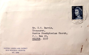
Document, Envelope addressed to E.W Barrie, Unknown
Ernest “Bonnie” Wesley Barrie was a member of the Presbyterian Board of Management for more than 25 years in which he held positions of Honorary Secretary and Treasurer, Board member of the Parish Council and Member of the Committee of Management. He was a Sunday school teacher 1933.Envelope addressed to E.W Barrie, treasurer of Scots Church from Bacchus Marsh and District War Hospitalchurches, local identities -
 St Kilda Historical Society
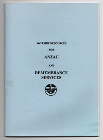
Booklet, East St Kilda Uniting Church Parish Council, Worship Resources for ANZAC and Remembrance Services, 1995
Booklet of resources for Ministers of the Uniting Church in Australia to use when participating in Anzac or other services held to remember Australians who have died in active service.Booklet of 35 pages with blue card cover. Stapled.Booklet of resources for Ministers of the Uniting Church in Australia to use when participating in Anzac or other services held to remember Australians who have died in active service.st george's east st kilda uniting church -
 Eltham District Historical Society Inc
Document - Survey Plan, Country Roads Board, SP 6561, Eltham-Yarra Glen Road; Park Rd to Bellevue Rd, 1957
1957 C.R.B. Plan of Survey of Parts of Crown Allotment 1 & Crown Allotment F, Section II Parish of Nillumbik, County of Evelyn Eltham-Yarra Glen Road, Shire of Eltham Shows Surveyor field notes, property ownership and building type and construction.eltham-yarra glen road, country roads board, eltham, main road, survey plan, 1957, a.r. thomas, b. & b.d. hearn, b.g. anderson, bellevue road, e.m. pitts, f.a. m. macrae, g.e. & b. moulder, j. bromley, j.m. & s.g. johnstone, k.f. pitts, l.c. docksey, m. & e.c.w. baart, m.p. bromley, n.r. ord, p.j. & g.e. murphy, park road, r.a. bruce, r.a. macbeth, r.w. shearing, railway road, s.e. & y.p. houghton, w.k. bell, w.s.r. & f.n. toley, neil webster collection -
 Greensborough Historical Society
Map, Melbourne and Metropolitan Board of Works. Survey Division, MMBW, Yarra 2500 / 17.27. Central Hurstbridge, 1978_02
Melbourne and Metropolitan Board of Works. Yarra 2500 [base map] 17-27. Central Hurstbridge. Parish of Greensborough 2724, Municipalities of Diamond Valley 257, Eltham 238 and Whittlesea 239. Prominent streets include: Anzac Avenue and Hurstbridge-Arthurs Creek Road. MMBW Map in 1:2500 [scale] series. Cream parchment with green tape reinforcing on edges and punched holes on left edge.mmbw, melbourne and metropolitan board of works, shire of diamond valley, hurstbridge - maps -
Clunes Museum
Certificate, SWAINSON FAMILY, STATEMENT OF RECEIPTS AND EXPENDITURE
CERTIFICATE OF ESTATE FROM THE SWAINSON FAMILY HOME IN HILL STREET, CLUNES. THAT BEING SALE OF ASSET/S, LAND AND DWELLING, BEING ALLOTMENT 11, SECTION 6, TOWNSHIP OF CLUNES, PARISH OF CLUNES, COUNTY OF TALBOT. SOLD TO MRS. C.K. BUCHANAN. 1918-1919PHOTOCOPIES OF: .1 THE BALLARAT TRUSTEES EXECUTORS & AGENCY COMPANY LIMITED. STATEMENT OF RECEIPTS & EXPENDITURE FOR AND ON A/C OF ESTATE OF JOHN SWAINSON DECEASED DATED 23/9/1919 .2 & .3 PHOTOCOPIES OF THE BALLARAT TRUSTEES EXECUTORS & AGENCY COMPANY LIMITED. ESTATE OF JOHN SWAINSON DECEASED DATED 23/9/1919 .4 COVER LETTER FROM THE BALLARAT TRUSTEES EXECUTORS & AGENCY COMPANY LIMITED TO MRS. L.E. SWAINSON WIDOW OF JOHN SWAINSON DATED 17/10/1918 CHEQUE IN THE AMOUNT OF 93 POUNDS, 19 SHILLINGS AND ZERO PENCE IN LIEU OF THE SIGNED RELEASE.NILlocal history, certificates, swainson family, mrs. c k buchanan -
 Bendigo Historical Society Inc.
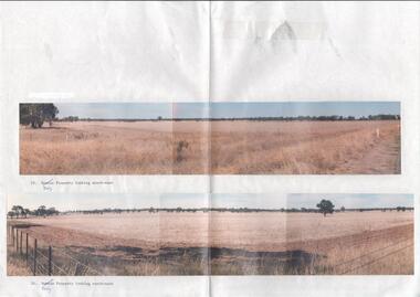
Photograph - Kangaroo Flat Gold Mine Collection: photos of Woodvale site, Daly property, pre dam construction, 1986
Photographs taken at the time of the purchase by Western Mining Corporation of the property owned by G.P. Daly of Raywood Road, Woodvale, in 1986. The intent of the purchase was to provide land for the Woodvale ponds. Land size was 16 acres, known as Allotment 13, Section 3, Parish of Nerring. Paper with two colour photographs attached, each of three photos joined to show landscape view, of the property purchased from G.P Daly by Western Mining Corporation. Photographs show rural land, grassy paddocks with tree line in background. Barb wire fence visible in foreground of bottom photo. Top photograph is titled 23. Daly property looking south-east. Bottom photograph is titled 24. Daly property looking north east. woodvale, g.p. daly, western mining corporation, purchase -
 Bendigo Military Museum
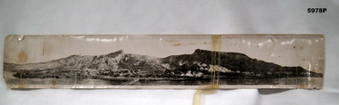
Photograph - PHOTOGRAPH, GALLIPOLI, cWW1
Original owner - Stephen John PARISH Regiment number/ Unit 703, Enlisted 19-08-14 F.COY 8th Battalion Became an officer 2nd Lieutenant in 1st Machine Gun Battalion RTA 17-03-1919 See also Cat No. 5979.6.Original photograph - black and white on photographic paper. Scene depicts landing boats, beach scene, an encampment with tents and small buildings with background of ridges. Handwritten greeting and information on back of photograph. Panorama photograph.Handwritten in faded black ink - back of photograph "Clevedon/ 3/7/18/ Just a picture of Gallipoli/ if you show it to any of/ the boys that have been/ there they will explain it/ better than I can by writing/ best love/ Ste ? xx" Handwritten in mainly uppercase letters, blue ink. Left to Right - " MOST OF OUR/ SUPPLIES WERE/ LANDED HERE" " THE LAST OF/ THE AIF LEFT/ HERE 29-12-1915" " 1ST AIF DIVISION/ LANDID (sic) HERE/ 25-4-1915" " THIS PERE WAS/ RECKED (sic) SEVERAL/ TIMES BY STORMS" " 1ST AIF/ HOSPITAL TENTS " TURKS BEACHIE (sic) / FIRED SCHRAPNIL/ ALONG BEACH/ FROM HEARE (sic)" " 4th INF BGDE/ Faught (sic) have/ on 9-5-1915" . "photographs, ww1, gallipoli, s. j. parish, 8th battalion -
 Bendigo Historical Society Inc.
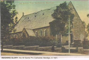
Newspaper - JENNY FOLEY COLLECTION: REIGNING GLORY
All Saints in McKenzie Street was opened in 1856 (nave) and was the Anglican Parish Church until 1902 when the Bendigo diocese was established. At this time it was designated a cathedral. In 1981, St Pauls in Myers street became the new cathedral and All Saints was eventually closed in 1989.Bendigo Advertiser ''The way we were'' from 2002. Reigning glory: the All Saints Pro Cathedral, Bendigo, in 1921. The clip is in a folder.newspaper, bendigo advertiser, the way we were -
 Federation University Historical Collection
Plan, Department of Crown Lands and Survey, Melbourne, Buninyong County of Grant, 23/07/1929
The plan was photo-lithographed at the Departmen tof Lands and Survey, MelbourneA parish plan of Buninyong, including Robert Scott's Mt Buninyong Pre-emptive Right, Mt Buninyong Public Park, Thomas Learmonth's land, John Learmonth's land, Scotchan's, Yendon. The Buninyong POst Office is Allotment 1. Pisition of tracks in 1859 have been marked on the plan in red.buninyong, scotchman's, mt buninyong, robert scott, clarendon, lal lal creek, yendon, warrenheip, yarowee, enfield, thomas learmonth, john learmonth, archibald fisken, g. schloo, george innes, peter inglis, durham lead, j. fry, j. forrest, parkin lee, buninyong recreation reserve -
Bendigo Historical Society Inc.
Document - LYDIA CHANCELLOR COLLECTION: THE UNITING CHURCH IN AUSTRALIA BENDIGO WEST PARISH FOREST ST CONGREGATION LETTER, 1993
LYDIA CHANCELLOR COLLECTION: The Uniting Church in Australia Bendigo West Parish Forest St Congregation Letter To the Congregation Members 12th August 1993 from Ruth Hosking Secretary, Council of Elders. A Comprehensive description of a proposed outreach ageny of the Uniting Church to be known as 'Bendigo Uniting Church Outreach'bendigo, history, churches