Showing 25579 items matching "plenty-township-estate"
-
 Kew Historical Society Inc
Plan - Subdivision Plan, Kewdene Estate, 1937-1939
Pru Sanderson, in her groundbreaking ‘City of Kew Urban Conservation Study : Volume 2 - Development History’ (1988), summarised the periods of urban development and subdivisions of land in Kew. The periods that she identified included 1845-1880, 1880-1893, 1893-1921, 1921-1933, 1933-1943, and Post-War Development. These periods were selected as they represented periods of rapid growth or decline in urban development. An obvious starting point for Sanderson’s groupings involved population growth and the associated economic cycles. These cycles also highlighted urban expansion onto land that was predominantly rural, although in other cases it represented the decline and breakup of large estates. A number of the plans in the Kew Historical Society’s collection can also be found in other collections, such as those of the State Library of Victoria and the Boroondara Library Service. A number are however unique to the collection.The Kew Historical Society collection includes almost 100 subdivision plans pertaining to suburbs of the City of Melbourne. Most of these are of Kew, Kew East or Studley Park, although a smaller number are plans of Camberwell, Deepdene, Balwyn and Hawthorn. It is believed that the majority of the plans were gifted to the Society by persons connected with the real estate firm - J. R. Mathers & McMillan, 136 Cotham Road, Kew. The Plans in the collection are rarely in pristine form, being working plans on which the agent would write notes and record lots sold and the prices of these. The subdivision plans are historically significant examples of the growth of urban Melbourne from the beginning of the 20th Century up until the 1980s. A number of the plans are double-sided and often include a photograph on the reverse. The advertisement for the ‘Kewdene Estate’ subdivision is pasted over a photograph of a property for sale. This is typical of the reuse of promotional materials in the period during, and subsequent to World War I. The subdivision included 14 lots bordered by Belmore Road, Birtles Street and Giles Street. On the other side of the subdivision [Glass] Creek is noted. The subdivision plan also shows part of the Outer Circle Railway and Deepdene Railway Station.subdivision plans - east kew, kewdene estate, belmore road -- kew east (vic.), giles street -- kew east (vic.) -
 Greensborough Historical Society
Map, Melbourne and Metropolitan Board of Works. Survey Division, MMBW, Yarra 2500 / 12.24. Plenty and Blue Lake, 1977_10
Melbourne and Metropolitan Board of Works. Yarra 2500 [base map]. 12-24, Municipalities of Whittlesea 239 and Diamond Valley 257. Shows street names, easement sizes, lot numbers, lodged plan numbers, names of prominent features, contour values, creek or river names. Watsonia Railway Station and environs. Prominent streets: Memorial Drive. Includes Plenty River and Blue Lake in the Plenty Gorge.MMBW Map in 1:2500 [scale] series. Cream parchment with green tape reinforcing on edges and punched holes on left edge.mmbw, melbourne and metropolitan board of works, shire of diamond valley, plenty - maps, blue lake -
 Greensborough Historical Society
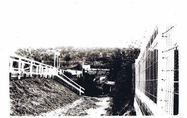
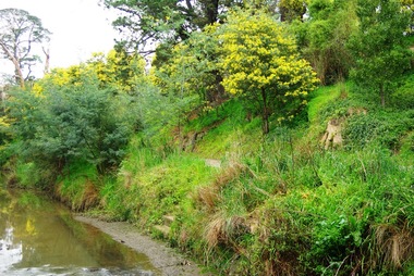
Photograph (copy), Plenty River Tea Gardens, 1929c
Plenty River Tea Gardens were located on east side of Main Street near St Helena Road intersection. [Ref: The Age 18/2/1929 page 3 - Greensborough - Comfortable Home. 6 rooms. large verandas. ½ acre. S O bungalow. Lovely spot. 4 minutes station. Furnished or unfurnished or will sell reasonable. River Plenty Tea Gardens. Phone Gr. 17]Two black & white photographsplenty river tea gardens, greensborough tea rooms -
 Kew Historical Society Inc
Plan - Subdivision Plan, Corsewall Estate, 1938
The Kew Historical Society collection includes almost 100 subdivision plans pertaining to suburbs of the City of Melbourne. Most of these are of Kew, Kew East or Studley Park, although a smaller number are plans of Camberwell, Deepdene, Balwyn and Hawthorn. It is believed that the majority of the plans were gifted to the Society by persons connected with the real estate firm - J. R. Mathers and McMillan, 136 Cotham Road, Kew. The Plans in the collection are rarely in pristine form, being working plans on which the agent would write notes and record lots sold and the prices of these. The subdivision plans are historically significant examples of the growth of urban Melbourne from the beginning of the 20th Century up until the 1980s. A number of the plans are double-sided and often include a photograph on the reverse. A number of the latter are by noted photographers such as J.E. Barnes.The Corsewall Estate was a subdivision, bordering on Barkers Road and Auburn Road, which created Corsewall Close. This relatively late subdivision included 29 allotments. The subdivision plan includes the dimensions of each lot as well as the width of the existing and projected roads and turning circles. The Corsewall Close Precinct is now listed on the Victorian Heritage Database (HO147) and is noted for its ‘consistent flat-type development over the entire street, which has been cleverly designed to make multi-unit dwellings appear as single buildings’.subdivision plans - hawthorn, corsewall estate -- hawthorn (vic.) -
 Greensborough Historical Society
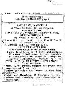
Newspaper - Newspaper Clipping (copy), The Argus, Sale: Wattle Bend ... on Plenty River 1925, 14/03/1925
An advertisement for the sale of "Wattle Bend" on the Plenty River, a guest house and orchard farm being offered for sale by Mr J. A. Bush in 1925Mr J. A. Bush was formerly known as Johannes Adem Bosch, an early Greensborough orchardist1 page copy of newspaper advertisement.plenty river, bosch family, bush family, wattle bend -
 Greensborough Historical Society
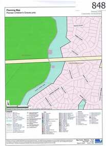
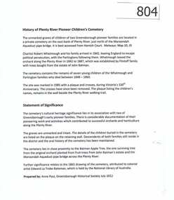
Map, Plenty River Children's Cemetery - location map, 1848-1860
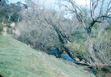
The unmarked graves of the children of two Greensborough pioneer families lie in a private cemetery on the Plenty River. Burials occurred between 1848 and 1860.The significance lies in the association with two of the pioneer families of the Greensborough district. Descendants of both families still live in the area.One page map accompanies article item #804 -
 Greensborough Historical Society
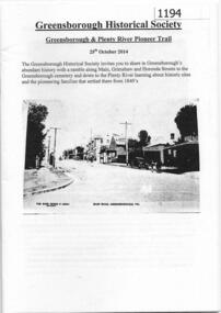
Booklet, Greensborough Historical Society, Greensborough and Plenty River Pioneer Trail, 25/10/2014
This booklet outlines the October 2014 guided walk through Greensborough, visiting Main and Grimshaw Streets, the Greensborough cemetery and along the Plenty River.24 pages, balck and white illus.greensborough historical society, plenty river heritage trail -
 Greensborough Historical Society
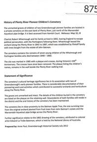
Article, History of Plenty River Children's Cemetery; by Anne Paul, 1848-1860
The unmarked graves of the children of two Greensborough pioneer families lie in a private cemetery on the Plenty River. Burials occurred between 1848 and 1860.The significance lies in the association with two of the pioneer families of the Greensborough district. Descendants of both families still live in the area.2 printed pages of text, one page map (item 848).pioneer childrens cemetery, plenty river, partington, whatmough -
 Greensborough Historical Society
Photograph - Digital image, Marilyn Smith, Plenty River bank stabilisation 2015; river bank, 16/08/2015
River bank stabilisation project along the Plenty River at Greensborough 2015, conducted by Melbourne Water. This photo shows the river bank in Greensborough.Digital copy of colour photographplenty river, melbourne water -
 Greensborough Historical Society
Photograph, Main Road bridge looking to township of Greensborough, 1929c
View of Main Street Greensborough from Partington's Hill including Plenty River bridge and Marble Hall on corner of Carter Street (now Para Road) and Main Street. This view of Greensborough Park shows the old pan toilets, the hawthorn fence line and the rather undeveloped roadside area of the park. Looking up Main Street we see the old Chapman house at the corner of Poulter Avenue and some newer houses below this. The stone river bridge appears to be only a single lane wide and the road approaching the bridge is unsealed. The rail bridge shows evidence of soot from steam trains and at the extreme left of picture the two concrete buildings indicate the line had been electrified. This occurred in 1923. Sparse housing is seen in the Flintoff Street and Grimshaw Street area.Part of a collection of photographic enlargements of views of Greensborough in the early 1900s.Black and white enlargement of photographic imagemain street greensborough, marble hall, greensborough railway, chapman house, greensborough park, poulter avenue greensborough, carter street, para road -
 Whitehorse Historical Society Inc.
Pamphlet, Hill 60 Estate, 1/02/1929 12:00:00 AM
Auctioneers brochure for Hill 60 estate,Auctioneers brochure for Hill 60 estate, Tunstall, 37 sites, subdivisional auction sale, 3.30 pm Saturday 23 February 1929. Agent: Frank Fisher & CoAuctioneers brochure for Hill 60 estate, hill 60 estate, tunstall, frank fisher & co, forest hill, menin road, nunawading, mount pleasant road, nunawading, shady grove, nunawading, fisher, frank -
Whitehorse Historical Society Inc.
Article, Hill 60 estate, 15/02/1929 12:00:00 AM
Advertisement for auction, Saturday 23 February 1929, of 37 sites on Hill 60 estate, Tunstall.Advertisement for auction, Saturday 23 February 1929, of 37 sites on Hill 60 estate, Tunstall. Agent: Frank Fisher & Co. from 'The Reporter' 15 Feb 1929.Advertisement for auction, Saturday 23 February 1929, of 37 sites on Hill 60 estate, Tunstall. hill 60 estate, tunstall, frank fisher & co -
Whitehorse Historical Society Inc.
Pamphlet, Barnes Estate, 1/10/1926 12:00:00 AM
Auctioneer's brochure for Barnes Estate, Blackburn.Auctioneer's brochure for Barnes Estate, Blackburn. Subdivisional auction, Saturday October 16, 1926 in Faulder Watson Hall, Barker Street, Castlemaine. Auctioneer; Frank Fisher & Co.Auctioneer's brochure for Barnes Estate, Blackburn. barnes estate, frank fisher & co, blackburn, francis street, blackburn, whitehorse road, blackburn motors -
Whitehorse Historical Society Inc.
Newspaper - Article, Lake Road Estate, 7/10/1970
'It's a genuine piece of Bellbird country' [ article on 36 lot subdivision, Lake Road Estate, Lake Road, Blackburn by developers Mark Padgett and Co Pty Ltd]mark padgett & co pty ltd, lake road, blackburn, lake road estate, land subdivision -
Whitehorse Historical Society Inc.
Document, Savage Estate, Nunawading, 1950?
A plan of the Savage Estate comprising of 46 lots on Savage Court, Colbar Street, Lemon Grove and Springfield Road.A plan of the Savage Estate comprising of 46 lots on Savage Court, Colbar Street, Lemon Grove and Springfield Road. For private sale. Agents: Drake & Co. and Armstrong & Hoath.A plan of the Savage Estate comprising of 46 lots on Savage Court, Colbar Street, Lemon Grove and Springfield Road.savage court, nunawading, drake & co., armstrong & hoath -
 Warrnambool and District Historical Society Inc.
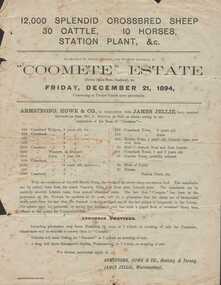
Document - Advertisement, Coomete estate, Sale of stock and plant, 1894
Augustus Bostock was the 9th child of Robert & Rachael Bostock of Vaucluse Epping Forest, Van Diemen’s Land. He was only 4 years old when his mother died. He was inspired by his father to seek his fortune in the Western District of Victoria. He arrived around 1850. He married Margaret Aitkin in July 1865. Augustus owned several properties in the district and leased others. He sat on the court of Warrnambool, Mortlake or Hexham as required. He resided at Marramook in Hawkesdale and later moved to Vaucluse in Hopetoun Road Warrnambool, where he died in 1920 at the age of 87. He was involved in many aspects of life in the Western District, racing, cricket, and social activities to name a few. This flyer is advertising the sale of 12000 sheep, 30 cattle, 10 horses and station plant at the expiration of the lease of Coomete. It states that Coomete has been in the possession of Mr. Augustus Bostock for over 30 yearsThis is one of a number of documents which relate to the Bostock family who were one of the most important pioneering families of the Western District. They owned and leased various properties around Warrnambool and were involved in many aspects of social and business life. This document contains a detailed view of the stock owned by Augustus Bostock at Coomete. From a social perspective the details provided show that it was an event of some importance in the farming area.Cream paper with heading and title in large font at the top with Coomete Estate in uppercase inside banner lines underneath with details of stock and numbers to be sold in smaller print below. Mercer printer Geelong. For further particulars apply to Armstrong, Howe & Co Geelong and Terang, James Jellie Warrnambool.coomete, warrnambool, augustus bostock, coomete lease, 1894 -
 City of Moorabbin Historical Society (Operating the Box Cottage Museum)
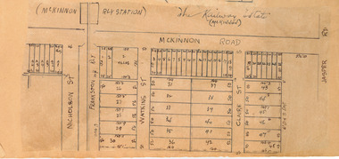
Plan - McKinnon Railway Estate, McKinnon, c 1921
At the end of World War One, there was a renewed interest in residential land and a number of estates opened up in the Municipality of Moorabbin. The train line from the city to Frankston was electrified in 1922 which intensified the sale in the municipality of Moorabbin, particularly land which was in the vicinity of the railway stations.Example of the progress of the Municipality of MoorabbinHand drawn plan of the McKinnon Railway Estate, McKinnonMcKinnon Railway Estate, McKinnon - hand drawn planmckinnon road, watkins street (now bent street), claire street, real estate, mckinnon, moorabbin -
 Greensborough Historical Society
Photograph - Digital image, Frank Robinson, Willows in the Plenty River, looking south west to cliffs, 1954_
Willows in the Plenty River, looking south west to cliffs. The Blackjack property, house and acres of fruit orchards ran down to the Plenty River off Hume Street Greensborough and was the home of the Robinson family to late 1956. The photographs were taken as slides by Frank Robinson and digitised by his son James in 2015. Oral history has it that Anthony Beale was the first to bring willow cuttings from the island of St Helena, to Australia.Digital copy of colour photograph.robinson family, blackjack, plenty river -
 Greensborough Historical Society
Article, Anne Paul, History of the Plenty River Pioneer Children's Cemetery, by Anne Paul, 2012_12
Unmarked graves of the seven children of the Whatmough and Partington families who died between 1848 and 1860 are in a private cemetery on the east bank of the Plenty River1 p., text with colour photographspioneer childrens cemetery, anne paul, whatmough family, partington family, cemeteries -
 Greensborough Historical Society
Article, History of Plenty River Pioneer Children's Cemetery by Anne Paul, 1848-1860
The Plenty River Pioneer Children's Cemetery contains unmarked graves of children from the Whatmough and Partington families who died between 1848 and 1860.The cemetery's significance lies in its connection with two of Greensborough's pioneer families. 4 pages, text and photographs.plenty river pioneer childrens cemetery, anne paul, partington, whatmough -
 Greensborough Historical Society
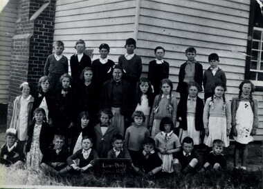
Photograph - Digital image, Lower Plenty State School 1942 LP1295, 1942_
Lower Plenty Primary School 1942. Photographs from the collection of Peter Blackbourn, a descendant of the Chapman Stock family. Annotations to photos by Peter Blackbourn.Digital copy of black and white photograph.peter blackbourn, lower plenty primary school -
 Greensborough Historical Society
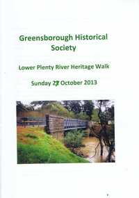
Booklet, Lower Plenty River Heritage Walk Sunday 27 October 2013, 27/10/2013
This booklet was used during the Heritage Walk along the Lower Plenty River in October 2013. It outlines natural and built landscapes of interest along this trail. 24 pages, illus. (some col.), maps.lower plenty, plenty river, lower plenty river heritage walk -
 Greensborough Historical Society
Newspaper Clipping, Diamond Valley Leader, Plenty of accidents, 27/09/2017
Plenty Road is the second most accident prone street in Australia, with eight pedestrians hit by cars outside La Trobe University this year alone.News article 1 page, black text.la trobe university, accidents, plenty road bundoora, traffic accidents -
 Greensborough Historical Society
Photograph - Digital Image, Marilyn Smith, Plenty River near Willinda Park, 06/11/2017
This group of photographs shows the Plenty River adjacent to Willinda Park. Willinda Park is situated in Beatrix Street Greensborough and has an athletics track and field. Digital copy of colour photographswillinda park, beatrix street greensborough, athletics, plenty river -
 Ringwood and District Historical Society
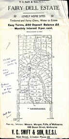
Flyer, Residential Land Sale Sub-division - Fairy Dell Estate, Warranwood, Vic. - circa 1950s
Land sale advertisement for 50 home sites with map of Sub-division showing layout of streets and allotments, summary of local features and services and terms of sale, and copy of sectional map of Crown Allotments 20 & 21B Parish of Warrandyte also showing layout of Sub-division.Subdivision includes Grandview Grove (later Bemboka Road), Merrill Crescent and Kerry Road, Warranwood. Estate Agents - V.C. Swift & Son R.E.S.I., Main Street, Croydon, Phone 20. Solicitors - Morgan, Fyffe & Mulkearns, 108 Queen Street, Melbourne. Handwritten 1970s real estate price notations for some blocks. -
 City of Moorabbin Historical Society (Operating the Box Cottage Museum)
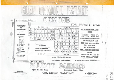
Flyer - Glen Ormond Estate, Ormond
At the end of World War One, there was a renewed interest in residential land and a number of estates opened up in the Municipality of Moorabbin.Example of the progress of the Municipality of MoorabbinPhotocopy of advertising flyer for sale of real estate sales - plan of building blocks for saleGlen Ormond Estate - For Private Sale - Home Sitesoakleigh road, ormond parade, kooringa road, leila road, huntly avenue, ormond, real estate -
 Halls Gap & Grampians Historical Society
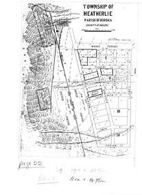
Map - Photocopy
Photocopy of map of Heatherlie TownshipTownship of Heatherlie; Parish of Boroka; County of Borung; scale measurement; R.O. Robson Authorised Surveyormaps, heatherlie township -
 Kew Historical Society Inc
Plan - Subdivision Plan, Oswinia Estate, East Kew, c.1925
Prue Sanderson, in her groundbreaking ‘City of Kew Urban Conservation Study : Volume 2 - Development History’ (1988), summarised the periods of urban development and subdivisions of land in Kew. The periods that she identified included 1845-1880, 1880-1893, 1893-1921, 1921-1933, 1933-1943, and Post-War Development. These periods were selected as they represented periods of rapid growth or decline in urban development. An obvious starting point for Sanderson’s groupings involved population growth and the associated economic cycles. These cycles also highlighted urban expansion onto land that was predominantly rural, although in other cases it represented the decline and breakup of large estates. A number of the plans in the Kew Historical Society’s collection can also be found in other collections, such as those of the State Library of Victoria and the Boroondara Library Service. A number are however unique to the collection.Subdivision plans are historically important documents used as evidence of the growth of suburbs in Australia. They frequently provide information about when the land was sold on which a built structure was subsequently constructed as well as evidence relating to surveyors and real estate and financial agents. The numerous subdivision plans in the Kew Historical Society's collection represent working documents, ranging from the initial sketches made in planning a subdivision to printed plans on which auctioneers or agents listed the prices for which individual lots were sold. In a number of cases, the reverse of a subdivision plan in the collection includes a photograph of a house that was also for sale by the agent. These photographs provide significant heritage information relating house design and decoration, fencing and household gardens.The ‘Oswinia Estate’ subdivision in East Kew was planned and auctioned in the first half of the 1920s. 169 allotments were created in the triangular section of land bordered by High Street, Burke Road and the Government Boulevard (later Kilby Road). The only piece of land excluded was that where the previous Kew Pound had been located at the east tip of the triangle. Allotments were created fronting Glass, High, Namur, Oswin Streets, Irymple Avenue, and the Government Boulevard. The name for the Estate was derived from Oswin’s farm, which had been one of the largest landholdings in East Kew. The selling agents annotated the plan in our collection with crosses indicating those lots that had been sold. The inset locality plan is particularly interesting as it shows the route and stations of the Outer Circle Railway. When the subdivision plan was created, it included the proposed bridge over the Yarra at Burke Road. The bridge was to be officially opened in 1926.subdivision plans - east kew, oswinia estate, high street, glass street, namur street, government boulevard - kilby road, irymple street, oswin street -
 Kew Historical Society Inc
Plan - Subdivision Plan, Normanby Heights Estate, Kew, 1919
Prue Sanderson, in her groundbreaking ‘City of Kew Urban Conservation Study : Volume 2 - Development History’ (1988), summarised the periods of urban development and subdivisions of land in Kew. The periods that she identified included 1845-1880, 1880-1893, 1893-1921, 1921-1933, 1933-1943, and Post-War Development. These periods were selected as they represented periods of rapid growth or decline in urban development. An obvious starting point for Sanderson’s groupings involved population growth and the associated economic cycles. These cycles also highlighted urban expansion onto land that was predominantly rural, although in other cases it represented the decline and breakup of large estates. A number of the plans in the Kew Historical Society’s collection can also be found in other collections, such as those of the State Library of Victoria and the Boroondara Library Service. A number are however unique to the collection.The Kew Historical Society collection includes almost 100 subdivision plans pertaining to suburbs of the City of Melbourne. Most of these are of Kew, Kew East or Studley Park, although a smaller number are plans of Camberwell, Deepdene, Balwyn and Hawthorn. It is believed that the majority of the plans were gifted to the Society by persons connected with the real estate firm - J. R. Mathers and McMillan, 136 Cotham Road, Kew. The Plans in the collection are rarely in pristine form, being working plans on which the agent would write notes and record lots sold and the prices of these. The subdivision plans are historically significant examples of the growth of urban Melbourne from the beginning of the 20th Century up until the 1980s. A number of the plans are double-sided and often include a photograph on the reverse. A number of the latter are by noted photographers such as J.E. Barnes.The Normanby Heights Estate not unusually used hyperbole to attract purchasers to the auction of 17 lots facing Argyle Street (sic), Pleasant Avenue and Normanby Road. Predictably factors appealed to included the proximity to schools etc, the availability of public utilities, friable soil, picturesque views and ‘advancing settlement’. If that were not enough, the sales pitch exhorted prospective purchasers to consider their backbone. ‘Thrift is unquestionably the Backbone of any Nation. No better form of Thrift can be encouraged in the young citizen than by investing his or her savings in a piece of land in a growing, healthy and beautiful locality. NORMANBY HEIGHTS ESTATE admirably fits the need.’ The experience of Australia at war undoubtedly contributed to the use of terms such as ‘Backbone of a Nation’ and the appeal to egalitarian principles in the choice of the term ‘young citizen’. The recognition that women had savings and might be the prospective purchaser also reflects a new sense of the rights and entitlements of women in the postwar period.subdivision plans - kew, normanby heights estate, pleasant avenue, normanby road, argyle street -
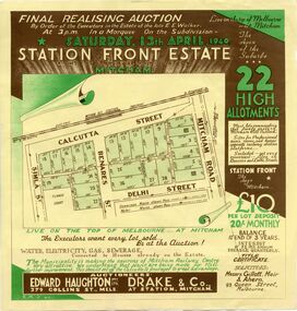 Whitehorse Historical Society Inc.
Document, Station Front Estate, 1940
Brochure advertising auction of 'Station Front estate'Brochure advertising auction of 'Station Front estate', Mitcham. 22 lots, 13 April 1940. Auctioneers Edward Haughton Pty Ltd, Drake & Co. Printed in two colours.Brochure advertising auction of 'Station Front estate'station front estate, auctions, calcutta street, mitcham, simla street, benares street, delhi street, mitcham road