Showing 112001 items
matching road
-
 Port Melbourne Historical & Preservation Society
Book, Rosalie Thrup Bray, "32 Gellibrand Road 3207, Life and times 1941-71", Jul 2013
Written and published by the author. Second edition printed 2014Book "32 Gellibrand Road 3207, Life and times 1941-71". Rosalie BRAY (THRUP). Green cover with photo of 32 Gellibrand Road on coverbuilt environment - domestic, garden city, education, war - world war ii, piers and wharves - princes pier, rosalie (rosie) bray nee thrupp, gellibrand road, fishermans bend, millie mclean, roy mclean, sandra sleeth, rene smith, dave mclean, phyllis moore, joe watson, nancy carroll, violet pope, len pope, june moore, lois moore, sis peat, mrs mills, mary edwards, alf edwards, judy faram, swallow & ariell ltd, robert harper & co ltd, j h boyd domestic college, mrs wood mewton, oranje, ss nairana, daisy thrup, rosalie (rosie) bray nee thrup -
 National Wool Museum
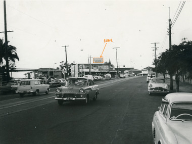
Photograph, Collins Bros Mill Pty Ltd, Physician Blanket Road Sign, Unknown
Advertising sign for the Physician Blankets Manufactured by Collins Bros Pty Ltd. Black and white photograph showcasing the Physician Blanket advertising road sign above a two story building in a landscape format. The road and moving cars are in the foreground.Front centre - Physician Chillproof Blankets. Sign Rear - Physician Brisbane (?) (?) Signwool, woollen mills, wool manufacture -
Whitehorse Historical Society Inc.
Map, Survey for road from Doncaster to Ringwood, 01/03/1867
Survey in County of Bourke, Road Plan no. 390, showing early routes of Doncaster, Whitehorse and Mitcham Roads.Survey in County of Bourke, Road Plan no. 390, showing early routes of Doncaster, Whitehorse and Mitcham Roads. Measurement in chains. Surveyor: Thomas E. Rawlinson.Survey in County of Bourke, Road Plan no. 390, showing early routes of Doncaster, Whitehorse and Mitcham Roads. parish of nunawading, parish of bulleen, whitehorse road mitcham, doncaster road, doncaster east, mitcham road mitcham -
 Whitehorse Historical Society Inc.
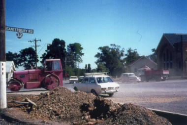
Photograph, Canterbury Road Vermont
Coloured print from a 110 slide of the construction of the dual highway in Canterbury Road and the Mitcham Road intersection. Note St Luke's Anglican Church on the right.canterbury road vermont, mitcham road vermont, st lukes anglican church vermont -
 Southern Sherbrooke Historical Society Inc.
Looking west down road to Selby from Hermons Corner
A herd of cows belonging to Ryan can be seen coming up the road by the Breen farm, Menzies Creek. Trees line the road. Hills are visible in the distance. -
 Halls Gap & Grampians Historical Society
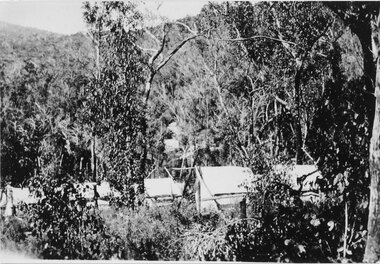
Photograph - Sepia, C 1920s
Photo is said to be that of roadmakers camp for workers on the construction of the Mt Victory RoadPhoto shows a number of tents in bush land, said to be road makers campRoad makers camp Mt Victory Rd during the dat 1920sstructures, tents, access routes, road building -
 Ringwood and District Historical Society
Map, Department of Mines, Plan of area applied for under the mining leases regulations in the township of Ringwood between Maroondah Highway and Mt. Dandenong Road. Mining District of Castlemaine, County of Mornington, Parish of Ringwood T Area 58(A) 2 (R)15(P) Acres, Roods, Perches. 1934, 20-Feb-34
Map of the township of Ringwood with subdivisions between Maroondah Highway and Mt. Dandenong Road. the area applied for on lease No.8210 by E.G.Browne.Mining District of Castlemaine, County of Mornington, Parish of Ringwood T Area 58(A) 2 (R)15(P) Acres, Roods, Perches.Buff coloured sheet foolscap with black printing showing map of the township of Ringwood between Maroondah Highway and Mt. Dandenong Road. Mining District of Castlemaine, County of Mornington, Parish of Ringwood T Area 58(A) 2 (R)15(P) Acres, Roods, Perches +Additional Keywords: Browne E.G. -
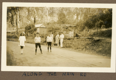 Mt Dandenong & District Historical Society Inc.
Photograph
The photograph is from the album of Ivy Child. The road featured called the 'Main Road' is what we know know as Mt Dandenong Tourist Road. It has been made but not tarred. The identity of the people is unknown. Ivy May Child (1910 – 1989) was the daughter of Arthur Edward (Ted) Child (1878 – 1964) and Ethel May Madden (1888 – 1970). Ted Child was the son of Matthew Francis Child (1839 – 1933) and Martha Jeeves (1857 – 1926). He was the grandson of one of the early pioneers Francis Child. Ivy grew up on the family property on Childs Road and took many photographs. Most of these are glued into her photo album. The album covered the years from c1927 – 1932. Ivy married Henry William Burgess (1906 – 1968) in 1944. The photographs remain in their original state in the album with individual copies made. Sepia coloured photograph showing a stretch of road with two young boys and a girl standing in the middle. Behind them, standing on the edge of the road are two women and a man. Behind them is a wire and post fence with wooden gate and a shed. Bush is visible in the background.Handwritten below the photograph in the album: ALONG THE MAIN ROADivy child, main road, mt dandenong tourist road, tourist road, kalorama -
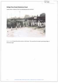 Greensborough Historical Society
Article and Photograph, Bridge at Para Road and Gladstone Road, 2018_
Information and photograph about the railway bridge at Para Road and Gladstone Road Greensborough.This photograph and text was copied from a Facebook site. Members are people who lived in the Greensborough area and share their reminiscences of the area with others. The site is administered by a GHS member but is not officially affiliated with the Society. Any information is the opinion of the contributor. Article and photograph sourced from social media.railway bridge greensborough, gladstone road briar hill, para road greensborough -
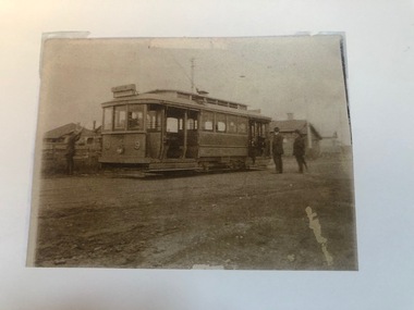 Melbourne Tram Museum
Photograph - Photograph Card, Keith Kings, Highfield Road terminus, Wattle Park, c2000?
Photograph - copied from an original print using a scanner and then printed on an A4 sheet of HTT 9 (could be 8) at the Highfield Road terminus, Wattle Park, 1925. The conductor is placing the trolley pole. A photocopied caption with the print notes as "The first tram along Riversdale Road to Highfield Road" See image i2 for further notes. Photo from Mrs Doris Turnbull of Essex Road.In pencil on the print "Keith Kings"trams, tramways, wattle park, highfield road, opening, conductors -
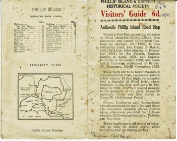 Phillip Island and District Historical Society Inc.
Booklet, Authentic Phillip Island Road Map, Pre 1960
Tourist brochure printed by the Phillip Island Printers pre 1960HistoricalSmall cream coloured brochure with details of accommodation, transport and animals. Inside is a map of the Island with numbered points of interest. There is also a plan of Cowes and drawings of animals.Visitors' Guide 6d Authentic Phillip Island Road Maptourist brochure, road map -
 Ringwood and District Historical Society
Photograph, Wantirna Rd, Ringwood - early view of unmade road with horse and cart (undated)
Written on back of photograph, "Wantirna Road, from Ron Anderson". -
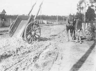
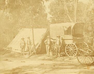 Ringwood and District Historical Society
Photograph, Road making in Ringwood (very old) (undated)
4 men in front of tent and wagon.Catalogue card reads, "Road making in Ringwood (very old)". -
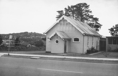 Ringwood and District Historical Society
Photograph, Ringwood Church of Christ Hall, Bedford Road, 1970
Written on backing sheet, "Church of Christ, Bedford Road, 1.11.70" -
 Ringwood and District Historical Society
Photograph, The Rest" tea rooms, Maroondah Highway, opposite Heatherdale Road
Black and white photograph of old brick building with scalloped roof-line. Decorative bricks in various places, particularly on top of windows and door.'The Rest' tea rooms, Maroondah Highway, opposite Heatherdale Road. -
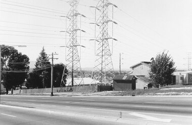 Ringwood and District Historical Society
Photograph, Maroondah Highway West, Ringwood- 1969. Pylons near Heatherdale Road
Black and white photographWritten on back of photograph: "May 1969-Near Heatherdale Road." -
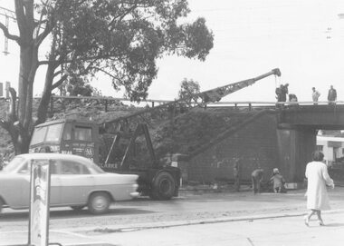 Ringwood and District Historical Society
Photograph, Maroondah Highway West, Ringwood, 1965. Wantirna Road bridge, start of widening
Black and white photograph (2 copies)Written on rear of backing sheet: "Wantirna Road bridge- the start". -
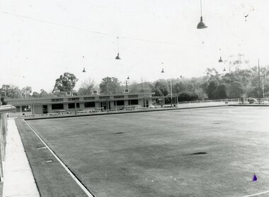 Ringwood and District Historical Society
Photograph, Ringwood Bowls Club - Warrandyte Road, 1991
Black and white photograph"On front of photograph" Ringwood Bowling Club Warrandyte Road, 1991 -
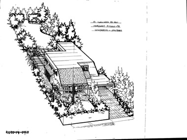 Hawthorn Historical Society
Drawing - Property Illustration, 41 Illawarra Road, Hawthorn
'After training as a Cartographic Draftsman within the mining industry, I worked as a property illustrator for real estate firms in the eastern suburbs of Melbourne for 23 years from 1983. I initially photographed houses with a Polaroid camera and made a 'thumbnail' sketch while there. The photos were used to scale off a sketch in pencil and then that sketch was overlaid with drafting film and the 'pen and ink' completed. The pens I used were the Rotring ‘Rapidigraph’ drafting pens. The ink was also made by Rotring (German).The film was ‘Rapidraw’, polyester drafting film, double matte. It takes a very fine line and doesn’t bleed. As well as house sketches, there were often floor plans and site plans ordered. Aerial sketches were ordered when the property needed an overall view.' (Margaret Picken, 2020)This property illustration is one of a series created by Margaret Picken for a range of real estate agents in Melbourne between c. 1983 and c. 2006. Each work is signed and dated by the artist.Gift of Margaret Picken, 2020pen and ink architectural drawing on drafting film.41 ILLAWARRA ROAD, HAWTHORN Margaret Picken ~94WOODARDS - HAWTHORNartist - margaret picken 1950- -
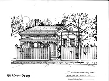 Hawthorn Historical Society
Drawing - Property Illustration, 27 Manningtree Road, Hawthorn
'After training as a Cartographic Draftsman within the mining industry, I worked as a property illustrator for real estate firms in the eastern suburbs of Melbourne for 23 years from 1983. I initially photographed houses with a Polaroid camera and made a 'thumbnail' sketch while there. The photos were used to scale off a sketch in pencil and then that sketch was overlaid with drafting film and the 'pen and ink' completed. The pens I used were the Rotring ‘Rapidigraph’ drafting pens. The ink was also made by Rotring (German).The film was ‘Rapidraw’, polyester drafting film, double matte. It takes a very fine line and doesn’t bleed. As well as house sketches, there were often floor plans and site plans ordered. Aerial sketches were ordered when the property needed an overall view.' (Margaret Picken, 2020)This property illustration is one of a series created by Margaret Picken for a range of real estate agents in Melbourne between c. 1983 and c. 2006. Each work is signed and dated by the artist.Gift of Margaret Picken, 2020pen and ink architectural drawing on drafting film.27 MANNINGTREE ROAD, HAW Margaret Picken ~97 WOODARDSartist - margaret picken 1950- -
 Ringwood and District Historical Society
Photograph, Joyce Chivers (Armstrong Road) (undated)
Black and white photographWritten on rear of backing sheet: "Joyce Chivers (Armstrong Road)." -
 Ringwood and District Historical Society
Photograph, Mr.W. Chivers (Armstrong Road) (undated)
Black and white photographWritten on rear of backing sheet: "W. Chivers (Armstrong Road)." -
 Ringwood and District Historical Society
Photograph, Wyn Chivers (Armstrong Road) (undated)
Black and white photographWritten on rear of backing sheet: "Wyn Chivers (Armstrong Road)." -
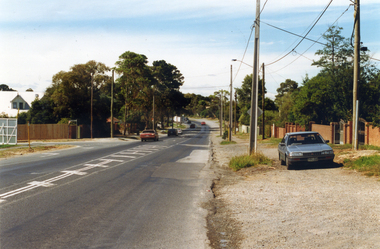 Whitehorse Historical Society Inc.
Photograph, Prior to Widening Mitcham Road, 1/02/2000 12:00:00 AM
Coloured photograph of Mitcham Road looking back towards Mitcham. Nursery on left and Mulsanne Street on left. Photo taken before construction to widen Mitcham Road.mitcham road, donvale, mulsanne street -
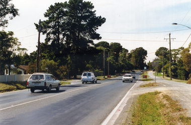 Whitehorse Historical Society Inc.
Photograph, Mitcham Road Prior to Widening, 1/02/2000 12:00:00 AM
Coloured photograph of Mitcham Road looking South towards Mitcham. Ruby Street on left, William Street on right. Taken prior to construction to widen Mitcham Road.mitcham road, donvale, ruby street, william street -
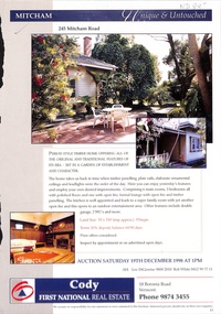 Whitehorse Historical Society Inc.
Pamphlet, Mitcham Road, Mitcham, 1/12/1998
Auction brochure for 245 Mitcham Road, Mitcham, 19 December 1998. 3 bedroom timber house. Agent: Cody First National, Boronia Road, Vermont.mitcham road, mitcham, no 245, auctions -
 Whitehorse Historical Society Inc.
Photograph - B/W Photograph, Blackburn Road Blackburn, 1918
Black and white photo of Blackburn Road looking south to Railway Road. !918. Note gatekeepers house on the left. See page 24 of Da Costa Book.blackburn road, blackburn -
 Whitehorse Historical Society Inc.
Photograph, Blackburn Road, 1918
Used by donor in 'Blackburn - a picturesque history'Black & white photo of Blackburn Road looking south from Railway Road. Note gatekeeper's house on left. See page 24 of Da Costa book.blackburn road blackburn -
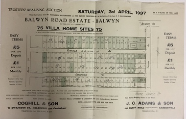 Kew Historical Society Inc
Plan - Subdivision Plan, Balwyn Road Estate, Balwyn (1937), 1937
Historic subdivision in Balwyn, VictoriaSubdivision Plan of Balwyn Road Estate (Balwyn). Held in April 1937, the auction included 102 lots for sale in Yongala Avenue, Young Street, and Balwyn RoadInscriptions on individual lots by agentsubdivision plans - balwyn (vic), balwyn road estate - balwyn -
 Whitehorse Historical Society Inc.
Photograph, Whitehorse Road Mitcham, C1940s
Black and white photo of Whitehorse Road, Mitcham - 1940s. Whitehorse Road looking south-west from ouside front of Memorial Hall towards Reserve Hotelwhitehorse road, mitcham