Showing 17376 items
matching view-master
-
 Eltham District Historical Society Inc
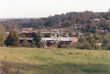
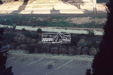
Photograph, Baldwin Avenue from Mountain View Road, Montmorency, c.1972, 1972c
Shire of Eltham road construction and realignment works on Baldwin Avenue, Lilicur Road and Price Avenue, Montmorency, c.197235mm colour positive transparency blue Agfacolour Service plastic mountbaldwin avenue, infrastructure, mountain view road, road construction -
 Eltham District Historical Society Inc
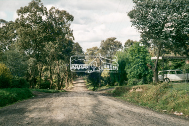
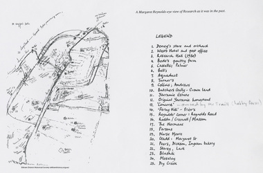
Document - Map, Margaret Reynolds, A Margaret Reynolds-eye view of Reseach as it was in the past, 1989
Reproduced in Return to Research : a centenary history of Research Primary School / edited by Andrew LemonA4 photocopy andrews, bell, blashik, bode's poultry farm, butchers gully, cassells, collins, concord, creswell, dickson, doney's store, dry creek, ferny hill, gadd, ingram bakery, lack, margaret reynolds, margaret street, maroondah aqueduct, masson, moseley, normans, nurse moore, palmer, parsons, peers, prior, research (vic.), research hall, reynolds corner, reynolds road, rodda, storey, traill property, turner, west's hotel, yarramie estate -
 Eltham District Historical Society Inc
Photograph, View looking up 'Policeman's Hill' on Main Road from Dalton Street showing Police Residence, c.1906, 2010c
For original image see EDHS_00533 This photo was originally mounted on 3mm MDF fibre board with notes and stickers applied as part of a display on the former Police Residence and now present day Local History Centre, home to Eltham District Historical Society; possibly put together by Harry Gilham during his time as president of the society. Eltham Police Station and Residence: A brief history 1860 Eltham Courthouse built in Main Road, together with an adjoining police residence, office, lock–up and stables. 1959 Police Department purchases a house in Pryor Street to be refurbished as Eltham Police Station 1961 Police in Eltham move into Pryor Street refurbished buildings and office. c.1961-1981 Occupied by Vermin and Noxious Weeds Destruction Section of the Department of Crown Lands and Survey. Former Police Station dragged around to rear of Police Residence (prior to August 1967) to make way for the construction of a driveway and access from Main Road. The building was placed on the site of a former Scullery and modified for Lands Department use. 1981 Shire of Eltham take over management of old Police Residence in Eltham. It remains unoccupied for a period of time whilst its future is discussed in Council. 1981-1985 Used for community job creation scheme 1985 Shire of Eltham Parks and Environment occupy the residence. Council improve the driveway but later add a second rear access from Brougham Street due to the dangerous nature of the Main Road entrance. Also add a rear toilet facility between the Police Residence and former Police Station, which was doubling up as a lunch room. Council also commence discussions to re-establish a replica Police Station. c.1986 November. Former Police Station demolished; believed to have been suffering termite damage. c.1989 After some years of discussion a replica Police Station is built, based on photographs, to act as a lunch room and meeting room for Parks and Environment staff and volunteers doing community service. 1996 Eltham District Historical Society in discussions with Nillumbik Shire Council commisioners throughout the year regarding a home for the Society. A proposal put forward by the Society in October to occupy the former Police Residence. 1997 March. Eltham District Historical Society gains access to former Police Residence. 1998 July 12th. Eltham District Historical Society Inc moves into its Local History Centre, 728 Main Road Eltham (the former Police Residnce built in 1860). 2018 July. Eltham District Historical Society gains access to the replica Police Station for use as part of regular heritage tours for schools and community based groups.Black and white photocopyLabels and handwriting in pencil and ink identifying various buildings. Also highlighted is the acetylene gas lamp and on reverse is written "Lamplighter Jimm Saville"728 main road, eltham, local history centre, parks and environment, police residence, police station, shire of eltham -
 Eltham District Historical Society Inc
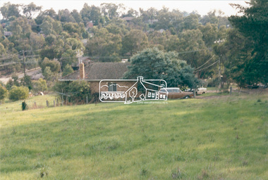
Slide, View of Martin's house indicating its relationship to the gully, Bonds Road, Lower Plenty, 18 July 1972, 1972
Water drainage work undertaken by Eltham Shire Council in Bonds Road, Lower Plenty outside the Martin property opposite Montpelier Drive, July 1972 35 mm colour positive transparency Mount - Agfacolor Service (Blue)Bonds Road (Martin property) 12.10 pm 18.7.72bonds road, drainage works, eltham shire council, infrastructure, lower plenty, martin property, montpelier drive -
 Eltham District Historical Society Inc
Photograph, View from lounge room looking towards Pitt Street and Wattle Grove, 218 Pitt Street, Eltham, c.1985, 1985c
House was rented by Kim Tarpey between October 1983 and June 1985. It was one of the buildings originally part of Birds Orchard. Harold Bird was her landlord, a retired primary school teacher who, when she knew him was driving the mobile library bus. Her partner had him as a teacher at Montmorency Primary in grade 4. The house was next door to what is now a bushland reserve near the Pauline Toner Reserve. It was on the corner of Pitt and Arthur St - the driveway was near the roundabout and went off to the right of the driveway that now belongings to 220 Pitt street and which was bushland at the time. It was sold in 1985 and consequently demolished, a large house has replaced it. It was situated approximately where the front door of No. 218 is nowadays with the facade roughly in line with the now garage wall to the left of this front door.Digital file only - scanned from personal photo album on loan218 pitt street, eltham, houses, birds orchard, harold bird, kim tarpey, eucalyptus road -
 Eltham District Historical Society Inc
Photograph, View from back fence looking towards Pitt Street and Wattle Grove, 218 Pitt Street, Eltham, c.1985, 1985c
House was rented by Kim Tarpey between October 1983 and June 1985. It was one of the buildings originally part of Birds Orchard. Harold Bird was her landlord, a retired primary school teacher who, when she knew him was driving the mobile library bus. Her partner had him as a teacher at Montmorency Primary in grade 4. The house was next door to what is now a bushland reserve near the Pauline Toner Reserve. It was on the corner of Pitt and Arthur St - the driveway was near the roundabout and went off to the right of the driveway that now belongings to 220 Pitt street and which was bushland at the time. It was sold in 1985 and consequently demolished, a large house has replaced it. It was situated approximately where the front door of No. 218 is nowadays with the facade roughly in line with the now garage wall to the left of this front door.Digital file only - scanned from personal photo album on loan218 pitt street, eltham, houses, birds orchard, harold bird, kim tarpey, eucalyptus road -
 Eltham District Historical Society Inc
Photograph, View from back fence on to Eucalyptus Road. Pitt Street Reserve to the right, 18 Pitt Street, Eltham, c.1985, 1985c
House was rented by Kim Tarpey between October 1983 and June 1985. It was one of the buildings originally part of Birds Orchard. Harold Bird was her landlord, a retired primary school teacher who, when she knew him was driving the mobile library bus. Her partner had him as a teacher at Montmorency Primary in grade 4. The house was next door to what is now a bushland reserve near the Pauline Toner Reserve. It was on the corner of Pitt and Arthur St - the driveway was near the roundabout and went off to the right of the driveway that now belongings to 220 Pitt street and which was bushland at the time. It was sold in 1985 and consequently demolished, a large house has replaced it. It was situated approximately where the front door of No. 218 is nowadays with the facade roughly in line with the now garage wall to the left of this front door.Digital file only - scanned from personal photo album on loan218 pitt street, eltham, houses, birds orchard, harold bird, kim tarpey, eucalyptus road -
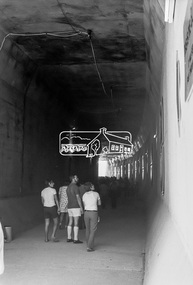
 Eltham District Historical Society Inc
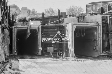
Photograph, George Coop, Open Day to view the Melbourne Underground Rail Loop (City Loop) construction, c.1980, 1983
Digital TIFF file Scan of 35mm Kodak Plus-X Pan black and white transparencycity loop, melbourne underground rail loop (murl), railway construction, tunnel -
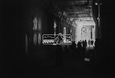
 Eltham District Historical Society Inc
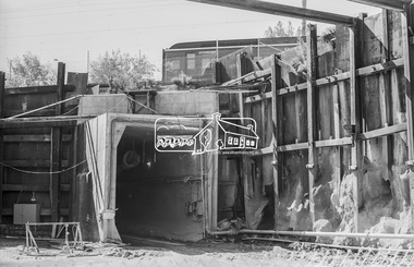
Photograph, George Coop, Open Day to view the Melbourne Underground Rail Loop (City Loop) construction, c.1980, 1983
Digital TIFF file Scan of 35mm Kodak Plus-X Pan black and white transparencycity loop, melbourne underground rail loop (murl), railway construction, tunnel -
 Eltham District Historical Society Inc
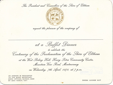
Card, Invitation to Buffet Dinner to celebrate the Centenary of the Proclamation of the Shire of Eltham at the West Riding Hall, Henry Petrie Community Centre, Mountain View Road, Montmorency, 7 April 1971, 1971
Originally donated in a photo album prepared by Doug and Gwen Orford of Historical Society trips.Invitation cardinvitation, activities, buffet dinner, henry petrie community centre, shire of eltham centenary -
 Eltham District Historical Society Inc
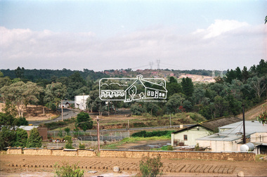
Photograph, View of Main Road from Eltham Shire Office, 895 Main Road, Eltham, 1967, 1967
35mm Colour positive transparency Mount - Agfacolor Service (Blue stepped)eltham shire office, main road -
 Eltham District Historical Society Inc
Photograph, View of Main Road from Eltham Shire Office, 895 Main Road, Eltham, 1967, 1967
35mm Colour positive transparency Mount - Agfacolor Service (Blue stepped)eltham shire office, main road -
 Eltham District Historical Society Inc
Photograph, View from Kangaroo Ground Tower, c.1966-c.1968, 1967c
35mm Colour positive transparency Mount - Agfacolor Service (Blue stepped)kangaroo ground, war memorial tower -
 Eltham District Historical Society Inc
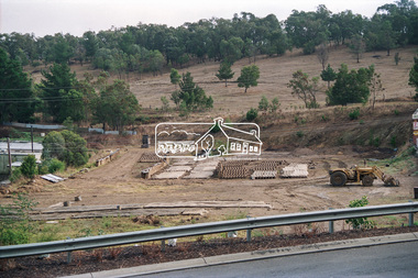
Photograph, General view, Riverhill Drive, Lower Plenty, c.March 1981, 1981
Infrastructure features used by Eltham Shire Council in the construction of Riverhill Drive, Lower Plenty, c.March 198135mm colour positive transparency Kodak Kodachrome cardboard mountinfrastructure, lower plenty, riverhill drive, road construction, streets -
 Eltham District Historical Society Inc
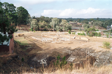
Photograph, General view of Riverhill Drive showing pits, Lower Plenty, c.March 1981, 1981
Infrastructure features used by Eltham Shire Council in the construction of Riverhill Drive, Lower Plenty, c.March 198135mm colour positive transparency Kodak Kodachrome cardboard mountinfrastructure, lower plenty, riverhill drive, road construction, streets -
 Eltham District Historical Society Inc
Negative - Photograph, View from Main Road, Research towards Maroondah Aqueduct Trail showing mudbrick manufacture, Research Industrial Estate, 1991
Roll of 35mm colour negative film, 9 strips olour print 10 x 15 cmFuji HG 200 CA-1main road, maroondah aqueduct, maroondah aqueduct trail, mudbrick, mudbrick construction, research (vic.), research industrial estate -
 Eltham District Historical Society Inc
Negative - Photograph, View towards Main Road, Research from Maroondah Aqueduct Trail showing mudbrick manufacture, Research Industrial Estate, 1991
Roll of 35mm colour negative film, 9 strips Colour print 10 x 15 cmFuji HG 200 CA-1main road, maroondah aqueduct, maroondah aqueduct trail, mudbrick, mudbrick construction, research (vic.), research industrial estate -
 Eltham District Historical Society Inc
Negative - Photograph, View towards Main Road, Research from Maroondah Aqueduct Trail showing mudbrick manufacture, Research Industrial Estate, 1991
Eltham Little Theatre in centre distance and new housing estate development off Reynolds Road in distanceRoll of 35mm colour negative film, 9 strips Colour print 10 x 15 cmFuji HG 200 CA-1eltham little theatre, houses, main road, maroondah aqueduct, maroondah aqueduct trail, mudbrick, mudbrick construction, research (vic.), research industrial estate, reynolds road -
 Federation University Historical Collection
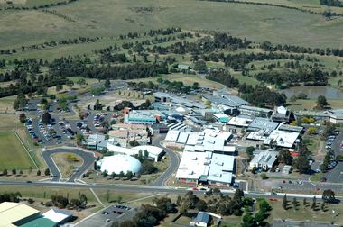
Photograph, Aerial View of the Mount Helen Campus
-
Federation University Historical Collection
Photograph, Aerial View of the Ballarat College of Advanced Education, 1986
Black and white photograph of the Mount Helen Campusmount helen campus, ballarat college of advanced education, aerial photograph, student residences -
Federation University Historical Collection
Photograph, View from Buninyong Lookout
buninyong lookout -
Federation University Historical Collection
Photograph, Aerial View of Mount Helen Campus
Two aerial viewls of Mount Helen Campusaerial, mount helen campus, buildings -
Federation University Historical Collection
Photograph, View of the Ballarat School of Mines Campus, c1982
ballarat school of mines campus -
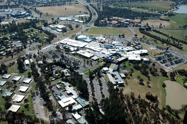
 Federation University Historical Collection
Photograph, Aerial View of Gippsland Campus, 2004
In 1989 Monash University took over the Gippsland Institute of Advanced Education to create Monash Gippsland Campus. In 2014 the University of Ballarat and the Churchill Campus of Monash University merged to become Federation University Australia.Photograph of the Federation University Gippsland Campus during its era as a campus of Monash University. gippsland campus collection, monash university gippsland campus, churchill, aerial -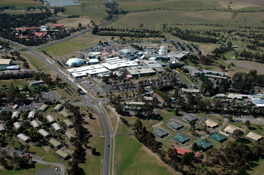
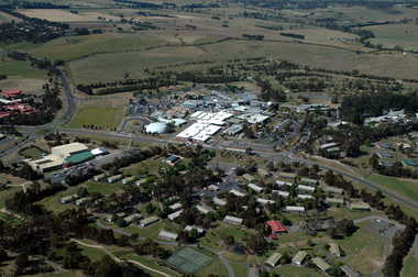
 Federation University Historical Collection
Photograph, Aerial View of Gippsland Campus looking over Northways, 2004
In 1989 Monash University took over the Gippsland Institute of Advanced Education to create Monash Gippsland Campus. In 2014 the University of Ballarat and the Churchill Campus of Monash University merged to become Federation University Australia.Photograph of the Federation University Gippsland Campus during its era as a campus of Monash University. gippsland campus collection, monash university gippsland campus, churchill, aerial, student residences -
 Federation University Historical Collection
Photograph, Aerial View of Gippsland Campus looking over the Student Residences, 2004
In 1989 Monash University took over the Gippsland Institute of Advanced Education to create Monash Gippsland Campus. In 2014 the University of Ballarat and the Churchill Campus of Monash University merged to become Federation University Australia.Photograph of the Federation University Gippsland Campus during its era as a campus of Monash University. gippsland campus collection, monash university gippsland campus, churchill, aerial, student residences -
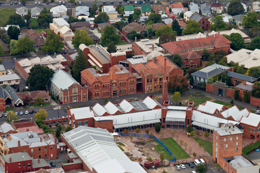 Federation University Historical Collection
Photograph, Aerial View of the Ballarat School of Mines
ballarat school of mines, smb, brew tower, administration building, ballarat technical art school, brewery building, former wesleyan church