Showing 124021 items
matching main-road
-
 Warrnambool and District Historical Society Inc.
Book, By These we Flourish, 1969
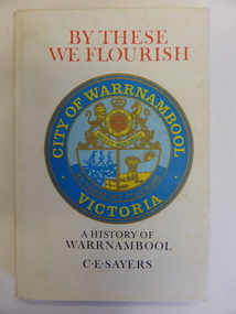
This book is a first edition of the Council-sponsored official history of Warrnambool. It was written by the professional historian, C.E. Sayers. He had access at the time to the notes, photographs, radio talks and other writings of the former Warrnambool Town Clerk and noted historian, Henri Worland. This book is of great importance as the chief comprehensive historical work published about Warrnambool since Vidler’s ‘Warrnambool Past and Present’ published in 1907. Even though a second edition of this book was published in 1987 this edition is still very important as it contains several photographs and some textual references not included in the later book. This edition is therefore still useful today and copies of it are not easy to find now. This is a hard cover book of 190 pages. The cover has a photograph in sepia tones of men road-making with the same photograph back and front. This has a cream background with red and black lettering and a coloured image of the Warrnambool City crest on the front. An early map of the Warrnambool township has been reproduced on the inside of the cover, back and front. The book has a foreword, an introduction, 21 chapters of text, notes and appendices. by these we flourish, history of warrnambool, c.e. sayers -
 Clunes Museum
Photograph
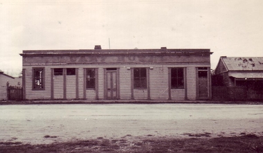
BLACK AND WHITE PHOTOGRAPH OF OLD CAMP HOTEL, TALBOT ROAD, CLUNES. PHOTOGRAPH FROM MR. E. SEMMENS, CRESWICK COLLECTION.BLACK AND WHITE PHOTOGRAPH OLD CAMP HOTEL TALBOT ROAD ABOUT OPPOSITE OLD SCHOOL, WHICH LATER BECAME INTERKNIT KNITTING MILL.local history, photography, photographs, hotels, old camp -
 Whitehorse Historical Society Inc.
Article, History is preserved
History is preserved.History is preserved - Historic Vermont Primary School has moved to its final home at the new Vermont Primary School in Nurlendi Road. With photo.History is preserved.primary schools, vermont primary school, no. 1022, vermont -
 Orbost & District Historical Society
newspaper, Snowy River Mail, 1.12.1976
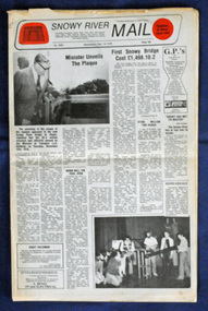
In early 1974, as an Engineer with the Country Roads Board, David came to Orbost as the Supervising Engineer for the construction of the new bridges which were part of an 8.4km Orbost bypass road design. This was a major project involving not only a new bridge over the Snowy River (including Lochiel Lagoon), but other bridges over Ashby’s Gulch and Watt’s Gulch. These new bridges were opened in November 1976 with the unveiling of a plaque on the eastern end of the $2.4M Snowy River Bridge. The new bridge, built by the CRB at a cost of $2.4 million, is 1.6 metres above the record flood levels of 1971. (ref. May Leatch) This newspaper contains contemporary reports of a significant event in Orbost.A Snowy River Mail newspaper, dated 1.12.1976. It contains news articles, photographs and advertisements. The main article relates to the official opening of the Snowy River Bridge and the unveiling of a plaque on the eastern approach. It also contains a history of the first Snowy River Bridge.snowy-river-bridge orbost-bridges snowy-river-mail -
![Construction of the electric tram line in Cotham Road [Kew]](/media/collectors/550653872162f11fb04854aa/items/66288f7f6214a76cee3ea3d8/item-media/66288fe96214a76cee3ead36/item-fit-380x285.jpg) Kew Historical Society Inc
Kew Historical Society IncPhotograph - Construction of the electric tram line in Cotham Road [Kew], E.J. Dower, 1913
One of a small album of six photographs of the construction of the Cotham Road tramline in Kew, taken by Edgar James Dower in the second decade of the twentieth century. The reverse of each photo contains notes, written over time by the photographer, which are contained in the 'Inscriptions' field. Born and raised in Olinda, Dower's family later moved to Surrey Hills. He worked as an adult as a clerk in the city office of the Metropolitan Gas Company, and in his role as a 'collector', he was able to photograph scenes including the construction of tram and train lines and associated buildings in Kew, Hawthorn, Camberwell and Surrey Hills. Later he established a real estate agency with his brother - the E.J. Dower Real Estate Agency, Dandenong Office. The album as a whole can be viewed separately as the parent file.The image is an historically significant record of the development of transport infrastructure which was used to connect Victorians in the first two decades of the twentieth century. This development resulted from increases in population and the consequent extension of Melbourne's suburbs. The photographs in the album, as well as Dower's single photos mounted on card, individually and collectively richly detail the labour of workers and the tools and machinery used to create and extend Melbourne's tram and train networks in the years preceding and during World War 1.The fourth of six annotated photos in an album of photographs of the construction of the St Kilda to Kew electric tram line, taken in Cotham Road, Kew, by the amateur photographer, Edgar James Dower, in 1913. The album contains images detailing the preparation for the laying of the tracks plus work laying the line. The photographer notes on a number of the photos that the metal tracks were collected from the Hawthorn railway siding. The album, together with other phots by E.J. Dower has been made available by the owners for the Kew Historical Society to digitise and publish online and in print.Annotation verso: "Preparing tram line Cotham Road Kew looking east for electric trams / 1913 / The metal was brought by horses and drays, from Hawthorn railway siding / 1913".keywords, theme -- connecting victorians by transport and communications, theme -- travelling by tram, photographers -- edgar james dower, cotham road -- kew (vic.) -
Glen Eira Historical Society
Newsletter - Caulfield Evangelical Methodist Church
This folder contains newsletters, articles and publicity about this Church: 1/Nine church newsletters dated from 1977 to 1978 including 2 editions of the Flame Vol No 9 June 1978 and Vol 1 No 10 July 1978. Newsletters document church meetings, clubs, congregation and home fellowship and also news of parishioners overseas. 2/Two undated publicity flyers. 3/One copy of the Evangelical Church Life September 1978 Vol 1 No 1 which includes photos and an article about this Church. One photo is if the Hawthorn Road building being demolished in September 1977. 4/ An undated 2 page publicity sheet for the church titled '10 Years' which inlcudes a black and white photo of the Methodist Church building in Glenhuntly Road about 1894.Also includes one website printout with church service times, meetings and bible study times. Dated 26/06/2012. 5/Photocopy of 'Caulfield Contact 23/07/1987 page 10 which has an article titled '10th Anniversary of Church' about this Church with a more expansive photo of the Glenhuntly Road church building circa 1894.caulfield evangelical methodist church, st giles presbyterian church, caulfield presbyterian church, caulfield continuing methodist church, st giles continuing presbyterian church, 'the flame', lamellah street, caulfield, wright graeme, hawthorn road, neerim road, wright heather, macdonald bell j, bell margaret, bell don, simmons des, beer david, continuing methodist church, simmons gwen, beer grace -
 Marysville & District Historical Society
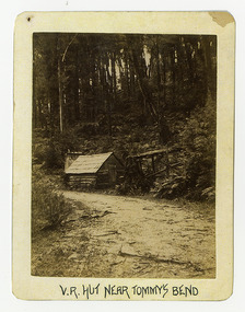
Photograph (Item) - Black and white photograph, V.R. Hut near Tommy's Bend, c1900
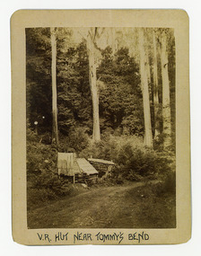
An early black and white photograph of a Victoria Roads worker's hut near Tommy's Bend near Marysville in Victoria. An early black and white photograph of a Victoria Roads worker's hut near Tommy's Bend near Marysville in Victoria. Tommy's Bend is a stretch of road 10 kilometres from Marysville on the Woods Point Road up to Lake Mountain.ARMSTRONG COLLECTION 42 STATION STREET/ SANDRINGHAM 3191/ TEL. (03) 9521 5442/ IAN M.L. ARMSTRONG OAMtommy's bend, marysville, victoria, marysville-wood's point road -
 Marysville & District Historical Society
Photograph (Item) - Black and white photograph, V.R. Hut near Tommy's Bend, c1900
An early black and white photograph of a Victoria Roads worker's hut near Tommy's Bend near Marysville in Victoria. An early black and white photograph of a Victoria Roads worker's hut near Tommy's Bend near Marysville in Victoria. Tommy's Bend is a stretch of road 10 kilometres from Marysville on the Woods Point Road up to Lake Mountain.ARMSTRONG COLLECTION 42 STATION STREET/ SANDRINGHAM 3191/ TEL. (03) 9521 5442/ IAN M.L. ARMSTRONG OAMtommy's bend, marysville, victoria, marysville-wood's point road -
Whitehorse Historical Society Inc.
Map, Alterations to residence, 1/02/1979 12:00:00 AM
Plans of proposed alterations and additions to residence for Mr. R. Doreian.Plans of proposed alterations and additions to residence for Mr. R. Doreian at 567 Whitehorse Road, Mitcham Scale 1:100,500|2 copies, 1 stamped APPROVEDPlans of proposed alterations and additions to residence for Mr. R. Doreian.dorien, bob, whitehorse road, mitcham no.567 -
 City of Kingston
Pamphlet - Black and white, Stott & Burke, Highland Estate Bentleigh, c.1915
Sales plan for land in the suburb of Bentleigh, along Collins and Ross Streets, bounded by Jasper Road.The developing urban area of Bentleigh within the City of Kingston. This land sale pamphlet illustrates the subdivision of land within the municipality and the changing demographic of the district as new houses are constructed.Black and white pamphlet advertising for private sale the Highland Estate, Bentleigh. Incorporates a map of the estate between Collins St and Ross St, bordered by Japser Road. Handwritten in grey pencil on map: additional subdivisions numbered 15-19 drawn along Ross St Handwritten in grey pencil on map: indecipherable annotations to subdivisions 1, 3 and 14land sales, bentleigh, estate -
 Bendigo Military Museum
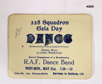
Flyer - CARD, GALA DANCE, Post 1943
228 Sqd RAF was a Sunderland Flying Boat Sqd during WW2. Item in the collection of Reginald Charles Allardice No 418557 RAAF. Refer Cat No 3627.5 for his service details.Soft card, square with round corners with printed details in dark blue relating to an upcoming RAF Gala Dance put on by 228Sqd for Mon 21st, 7.30 - 12 at the Dining Hall LLanion BarracksMain point, “By kind permission of Group Captain W.H.Hutton”dances, raf, ww2 -
 Stawell Historical Society Inc
Book, Oxford Press, New Testament, c. 1889
Subsequently belonged to L.W. Hamilton. 109 Hodkinson St, Clifton HillPercy S. Chandler Butchers Main Street Stawellstawell religion -
 Ballarat Tramway Museum
Photograph - Black & White Photograph/s, 1954
Yields information about the operation of trams in Sturt St during 1954 and tram 30.Black and white photograph of Ballarat No. 30 outbound in Sturt St with St Andrews Kirk (Church) in the background. Appears to have been taken from a motor car or truck, near the corner with Dawson St. 1954.On rear of photo "Tram in Main St at Ballarat 1954"trams, tramways, sturt st, tram 30 -
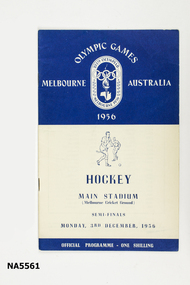 Whitehorse Historical Society Inc.
Programme - 1956 Olympic Games Official Programme Hockey semi-finals, Sands & McDougall, C 1956
- Belonged to Ian Howie- 16-page booklet - Programme for semi-finals MCG. 3rd Dec 1956Olympic Games. Melbourne, Hockey, Main stadium (MCG)1956, olympic games, hockey, programme -
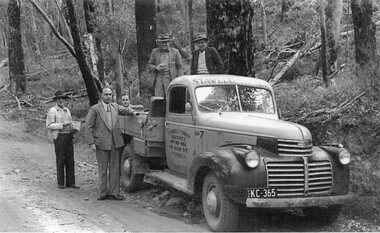 Stawell Historical Society Inc
Photograph, Stawell Timber Industries Truck 1940's
Used in the STI display in museumFive men with Stawell Timber Industries truck in bush settingStawell Timber Industries 141 Main Street Stawellmanufacturing -
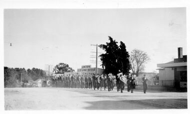 Linton and District Historical Society Inc
Photograph, Anzac Day march, Linton, 1950s
The photograph is undated but was probably taken in the late 1950s, as Morgan's store visible in the background appears to be owned by S E Morgan (Selwyn Morgan took over the store in 1956).Black and white photograph of a group of people marching along Sussex Street, Linton. A brass band leads the procession."Linton Anzac Day March in the Main Street, Linton".anzac day, sussex street linton, processions, parades -
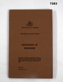 Bendigo Military Museum
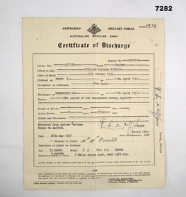
Administrative record - CERTIFICATE OF DISCHARGE 1975, Australian Military Forces, 30.9.1975
William Malcolm (Bill) Forrest, served Korea & Malaya. This certificate is his second enlistment. Refer Cat No 7281P for all his service history.Certificate of discharge AAT - A16 register No P147143. Certificate is attached to a brown buckram covered folding cover. The certificate has details re name, Regt No, rank, enlistment and discharge dates, previous service, postings and trade qualifications, decorations & medals, all print in black, signed in blue and black pen.Main points: "36283 William Malcolm Forrest Sergeant"certificate, discharge, korea, malaya -
 Bendigo Military Museum
Administrative record - CERTIFICATE, DISCHARGE 1957, Australian Military Forces, 28.5.1957
William Malcom (Bill) Forrest, served Korea & Malaya. Refer Cat No 7281P for his two periods of service engagements.Certificate of discharge form AAF A16 register No P35010, light yellow colour, all print in black and signed in blue pen. Certificate details re name, date of birth and place, rank, Regt No, enlistment and discharge dates, physical description.Main points: "5/1788 William Malcolm Forrest"certificate, discharge, korea, malaya -
![Photograph - Construction of the F19 [Eastern Freeway], Ron Setford, May 1976](/media/collectors/550653872162f11fb04854aa/items/6815afa28b33318343789e1c/item-media/6815afc88b33318343789fc9/item-fit-380x285.jpg) Kew Historical Society Inc
Kew Historical Society IncPhotograph - Construction of the F19 [Eastern Freeway], Ron Setford, May 1976
Ron Setford and his wife Grace Setford lived in Tanner Avenue, East Kew, from c.1946 to c.1995. A keen photographer, he recorded the changing face of Kew over a 20 year period. Apart from 30 photographs of built structures and places in Kew dating from 1960 and 1961, 145 of his 35mm colour slides chronicle the development of the F19 (later renamed Eastern) Freeway through the Yarra Valley in Kew over a five year period from c.1972 to c.1977. This important collection was donated to the Society by his granddaughter in 2025.This collection of 175 35mm slides is of local and statewide significance, owing to its subject matter, particularly the major development of road transport infrastructure during the 1970s with the construction of the Eastern Freeway. The photographer also took care to annotate and date most of his slides which enable the researcher to pinpoint temporal and spatial locations."Main bridges over Yarra River / Kew - Fairfield"ron setford, eastern freeway, f19 freeway -
 Ringwood and District Historical Society
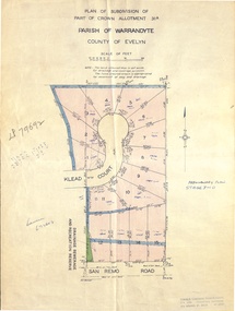
Document - Real Estate Folder, Savernake Estate, Ringwood, Victoria - Stage two - circa 1967
Plan of Subdivision PS79692, Part of Crown Allotment 31A Parish of Warrandyte, and advertisement for sale of residential allotments with map showing layout of Stage 2 of subdivision. Typewritten details for first and second release of Lots 10 to 16 with Terms of sale, stapled to two advertising flyers featuring map of estate showing Lots 1 to 20 on Evelyn Road, Cameron Road, Klead Court, and San Remo Road. Green slip included dated 6 July 1979 showing description of property at Lot 14 (no.4) San Remo Road, vendor - Judith Margaret Love and Lindsale Stephen Love, Cherry Tree Downs, Tarwin Lower 3456. Phone 056635390 Bus 056787203.Agent - C.E. Carter & Son, R.E.S.I. 126 Whitehorse Road, Ringwood. Telephones: 8706024, 8706830, 8702519, A.H.: 7233298, 8782648. Subdivision Plan stamped Donald Cameron Consultants Pty. Ltd., Consulting Engineers, 472 Bourke Street Melbourne - 67-2602. -
 Whitehorse Historical Society Inc.
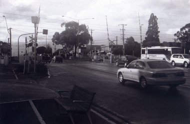
Photograph, Railway Crossing from the south, 1/06/2009
One of a collection of photographs taken of the Nunawading Railway Station prior to the lowering of the railway line and building of the new railway station on the western side of Springvale Road so that the Springvale Road Rail Crossing can be eliminated.Black & white photograph of the precinct surrounding the Nunawading Station and the Springvale Road Railway crossing. This photograph is south side of the crossing looking north. See NP 3545 to NP3567 for the complete set of photographsnunawading railway station, springvale road nunawading, redevelopment of railway line/springvale road. -
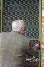
 Eltham District Historical Society Inc
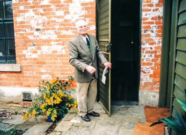
Photograph, Peter Bassett-Smith opens the door on to a new era for Eltham District Historical Society, 12 July 1998, 12/07/1998
Opening Ceremony of Local History Centre, 728 Main Road, Eltham, Sunday 12 July 1998Colour photographeltham district historical society, activities, eltham, main road, opening ceremony, local history centre, peter bassett-smith -
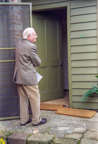
 Eltham District Historical Society Inc
Photograph, Peter Bassett-Smith tuns the key, 12 July 1998, 12/07/1998
Opening Ceremony of Local History Centre, 728 Main Road, Eltham, Sunday, July 12th, 1998Roll of 35mm colour negative film, 7 stripsKodak Gold 200-6activities, eltham, eltham district historical society, main road, opening ceremony, local history centre, peter bassett-smith -
 Eltham District Historical Society Inc
Photograph, Peter Bassett-Smith opens the door on to a new era for Eltham District Historical Society, 12 July 1998, 12/07/1998
Opening Ceremony of Local History Centre, 728 Main Road, Eltham, Sunday, July 12th, 1998Roll of 35mm colour negative film, 7 stripsKodak Gold 200-6activities, eltham, eltham district historical society, main road, opening ceremony, local history centre, peter bassett-smith -
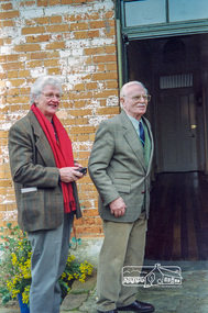 Eltham District Historical Society Inc
Photograph, Diana and Peter Bassett-Smith unlocking the door to the Local History Centre, 12 July 1998, 12/07/1998
Opening Ceremony of Local History Centre, 728 Main Road, Eltham, Sunday, July 12th, 1998Roll of 35mm colour negative film, 7 stripsKodak Gold 200-6activities, eltham, eltham district historical society, main road, opening ceremony, local history centre, peter bassett-smith, diana bassett-smith -
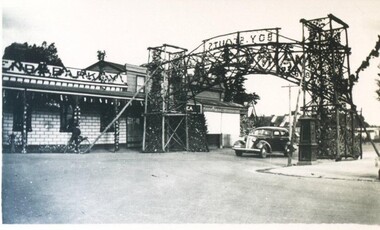 City of Ballarat Libraries
Photograph, Boy Scouts Celebratory Arch for Ballarat Centenary Celebrations 1938
The arch was erected on the corner of Main Road and Barkly Street. The building could be the Sir Henry Barkly Hotel. centenary, boy scouts, ballarat, barkly street, main road -
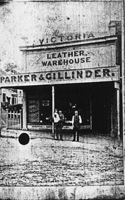 City of Ballarat Libraries
Photograph - Card Box Photographs, Victoria Leather Warehouse, Ballarat circa 1890
From copy of the original Chuck carte de visite. Located on the corner of Main Road and Humffray Street. victoria leather warehouse, parker & gillinder, main road, humffray street, building, persons, commerical -
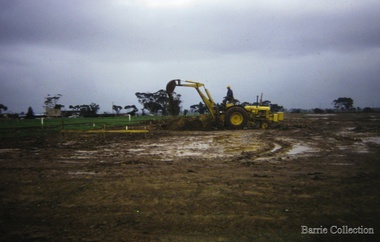 Melton City Libraries
Photograph, Building a new school, 1974
There were no high schools in the area pre 1975, and students from Melton, Melton South and Toolern Vale State Schools went by bus to Bacchus Marsh High School. In 1975, Melton High School opened its doors. Coburn Road named after Coburns, early settlers family and George Coburn Councillor and 1935 Shire PresidentEarth works undertaken for the development of Melton High School, Coburns Road, Melton Westeducation -
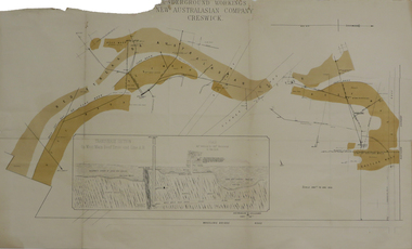 Federation University Historical Collection
Plan, Underground Workings New Australasian Company Creswick, not dated
A plan of the underground working of the New Australasian Mine at Creswick, showing Wheeler's Bridge Road, a transverse section on the West Main Reef Drive and Line AB. It als shows the locations of the Red streak or Australasian Gutter, Reef wash, Eastern Wash, Australasian and Eaglehawk Shaft and prospecting drives.mining, plans, cgt, creswick, new australasian company, wheeler's bridge, red streak gutter, australasian gutter, reef wash, eastern wash, australiasian shaft, eaglehawk shaft -
 Bendigo Historical Society Inc.
Photograph - LITTLE 180 MINE, 1920
black and white photo: street scene, blue stone gutter, wooden electricity pole, adult female standing on road, middle distance. In background, poppet legs, tall chimney, building At left. Striped pole in centre. On back of photo ' Main street Bendigo, leading to mine/1920 'cottage, miners