Showing 124011 items
matching main-road
-
 Bendigo Historical Society Inc.
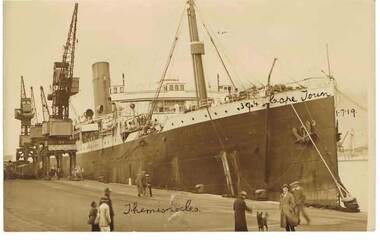
Photograph - ROBERT DENIS KELLY COLLECTION: THEMISTOCLES - LARGE SHIP, 1.7.1919
Black and white photo: large ship moored at wharf. Cranes on wharf side, people on wharf dressed in coats and hats. Handwritten on photo bottom 'Themistocles' handwritten on side of ship '304 Cape Town 1.7.19'.W. Fisher, Camp Road, Koeberg Road, Cape Townperson, robert denis kelly, world war 1, robert denis kelly, world war 1, ship, cape town. themistocles. -
 City of Kingston
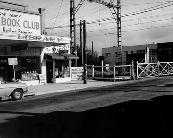
Photograph - Black and white, Public Transport Corporation, c. 1960
This image is part of a larger collection of images from the Public Transport Corporation displaying train stations and streetscapes in what is now the City of Kingston.The development of the railway was crucial to the ongoing development of the area. Community life sprung up around the railway line which is evident in the proximity of shopping and leisure.Black and white photograph of railway gates at Centre Road, Bentleigh.Black printed text on a small, round, white sticker on reverse: 227 Handwritten in red ink on reverse: 50% Black typed text on a strip of white paper stuck on reverse: Gates Centre Road Bentleigh / mid 1960 / $50 reproduction fee applies Blue ink stamped on reverse: COPYRIGHT / Public Transport Corporation / For re-ordering photographs / Please quote negative No H 3407 / Enquiries C/- PTC Photographic Unit / Telephone switchboard 619 1111bentleigh, railway crossing, trains, suburbs, shopping strip -
 Glen Eira Historical Society
Article - Shoobra Road, 80, Elsternwick, Karinya
Two items about 80 Shoobra Road. 1/ An advertising article dated 16/02/2011 from the Melbourne Weekly Bayside magazine; includes coloured photographs of property and selling features including renovation features. 2/ Research notes from Sands and MacDougalls on tenants and house name by Claire Barton.elsternwick, biggin & scott, fricker geo, shoobra road, estate agents, southern chas w.h., karinya, edwardian style, southern alb.c., leadlights, crowe amy, house names, architectural features, stavrakis bill, ivanhoe -
Glen Eira Historical Society
Drawing - Methodist Church, 23 - 25 Bundeera Road, Caulfield South
Phamphlet containing photocopied and dated newspaper articles about construction of church from various newspapers in 1926 and a brief outline of how and why church was begun and of its eventual demise, 1923 - 1985. Photocpied page of Recollections of Bundeera Road Church by Charlotte Harley (b. 1890), listing the members of December, 1985.methodist church, taylor mr., latham a. t., kindergartens, methodist uniting church, wesley johns rev., corben mrs, bundeera road, eddy r., organs, collier charitable fund, south caulfield, primary schools, kooyong road, methodist church, woodford, bambra estate, mcconchie rev. r. bruce, davenport mr., davies bill, davies mrs., philp rev., shaw mesolames, morris, miles, monday, bryant, woodford, paice, warren, evans bert, shaw william ronald, gvard w. h. rev., wells charlotte, evans elsie, narrawong road., bundeera road uniting church., mcraw dick, westaway frank, adamson dorothy, harley charlotte (nee wells), harley j, hunkin ena, hunkin edward rev., lydiard ruby, lydiard dick, sharples d, sharples j, spence margaret, spence bert, summers mary, summers ron, veitch alan, westaway m, arundell joyce, campbell heather, cock marian, heywood. a, putland roy, richards d, spence philip, taylor mrs., trewin norman, newton m., uniting church archives, kilgour alex, mann gwenda, gray daniel, gray gordon, heywood a, putland roy, richards d, featenby rev., brent p. e, woodford s. g., bent mr., st. kilda circuit, bundeera road ladies gvild, sunday school, choirs, windows -
Glen Eira Historical Society
Article - Creebank, 1 Carnarvon Road, Caulfield North
Original article from the real estate section of The Age newspaper, dated 08/10/1988. The article is written by Veronica Ridge and describes in detail the house at 1 Carnarvon Road, Caulfield North, called Creebank, to be auctioned 16/10/1988. The article includes a sketch (40mm x 56mm) of the house’s exterior.creebank, mansions, north caulfield, caulfield north, house auctions, historic buildings, architectural styles, victorian styles, architectural features, cast iron work, real estate agents, carnarvon road, dandenong road -
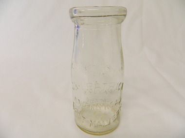
 Kew Historical Society Inc
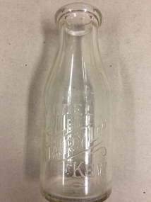
Container, Model Dairy, Milk Bottle, Twentieth Century
The Model Dairy was founded by the Kew pioneer, James Venn Morgan. The dairy had a number of different locations in Kew depending on the time period. Its final location was on the north side of Cotham Road, Kew between Ridgeway Avenue and Kent Street. Its final factory was designed by the architects Bates, Smart and McCutcheon.Kew was a major milk producing district in the Nineteenth and early Twentieth centuries, with three major dairy farms lining the Yarra between Studley Park in the west and Burke Road in the east. In addition to these dairy producers, there were also a number of accredited dairy retailers in the suburb. The largest and most enduring of these was the Model Dairy founded by the Kew pioneer James Venn Morgan. Milk bottles that include the name of the producer or retailer are historically significant as they represent a period in Kew's history before the mass production of milk in the second half of the Twentieth Century. A number of these named bottles have the additional attribute of rarity.Milk bottle - Model Dairy Kew. Pressed inscription: "Model Dairy Ltd Kew." Reverse: " This bottle contains milk bottled for sale by Model Dairey Ltd and always remains their property. It is loaned & cannot legally be used by others. One Imperial Pint. This bottle differs from 1981.0009 in that it does not have two pressed rings on the neck of the bottle.milk bottles, model dairy (kew) -
 Surrey Hills Historical Society Collection
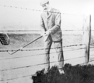
Photograph, Harry Culliton at Surrey Hills Golf Club
Reproduced by permission of Mr John Arnold from his book: "The Riversdale Golf Club - a history, 1892-1977." Copyright to book: Riversdale Golf Club. Surrey Hills Golf Club operated from 1892-1908 then moved and became Riversdale Golf Club. The game was played across paddocks from Trafalgar Street, Mont Albert to Whitehorse Road and down Victoria Crescent to where Box Hill TAFE is now located in Elgar Road. There were problems with cows eating the tee flags! The clubhouse still exists as 30 Trafalgar Street. The Surrey Hills Golf Club was founded by Mr Hugh W McLeod in 1894. The first president was Mr A W Harston. Mr William Meader was the first honorary secretary and the club champion for several years. Another notable identity was Mr. Harry Culliton, who contributed golf notes to "The Argus" for many years. Harry Culliton (clerk; later bank manager) married Christina Mary Rothwell of Surrey Hills in 1897. They initially live in Canterbury Road before moving to 'Bayview' in Harding Street. They had 3 sons. The eldest Kenneth Rothwell Culliton married Molly Fanny Arthur in 1940. They continued to live in 'Bayview'. Molly was a foundation member of the Surrey Hills Historical Society.The image is significant in documenting the Surrey Hills Golf Club, no longer in existence, but also members of early Surrey Hills families. Black and white photo showing a barbed wire and post fence behind which stands a man, identified as Harry Culliton. He is wearing a suit, cap and a tie. He sports a large 'handle-bar' moustache and is gripping an iron golf club, preparing to strike a golf ball which is impaled on the barbed wire.Caption: "Harry Culliton playing from the barbed wire where his ball was impaled on the fence on the side of the coffin. To his opponent's dismay he managed to land the ball near the green and get down in two for a half."sports grounds, surrey hills golf club, riversdale golf club, clothing and dress, john arnold, harry culliton -
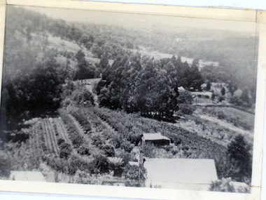 Mt Dandenong & District Historical Society Inc.
Photograph, 1913 View Over Logan's House in Village Settlement, 1913
Photograph taken in 1913 from Barbers Road showing the view down the valley. Roof in foreground is house on Bob Logan's Lot 28 in the Village Settlement. This photograph has a detailed inscription on the back handwritten by John Lundy-Clarke in 1974.1913 view over Logan’s house on Village Settlement Lot 28 taken from Barber’s Road. This is the house that the runaway log leaped over in 1930 to land far down the orchard row beyond the house. “Shiloah” is centre partly behind the clump of trees and the paddocks of Child and Richardsons pioneer selections are in the background. Link Road is centre right.logan, bob logan, robert logan, barbers road, shiloah, child, richardson, link road -
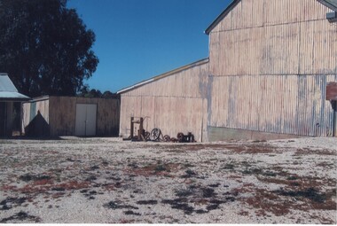
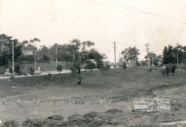 Eltham District Historical Society Inc
Photograph, Alistair Knox Park, Eltham, c.1970, 1970c
View from northwest corner showing survey pegs for trees and two ponds. Main Road has been duplicated. Bridge Street intersection showing the rock wall on the east side of the original Main Road (Maria Street). Burgoyne's Store and Eltham Uniting Church in distance at centre right and Our Lady Help of Christians at centre left.In February 1968 an unknown person took a series of photos from the Eltham Hotel at Pitt Street heading north along Main Road through the shopping centre to just north of Elsa Court covering the length of the section of Main Road which was duplicated shortly thereafter. Shows the condition and environment of the streesscape of Main Road, Eltham immediately prior to the duplication between Pitt Street and Elsa Court through the shopping centre. Also shows a number of shops and businesses that operated at that time.Black and white photographduplication, eltham, main road, bridge street, burgoyne's shop, eltham uniting church, our ladys church, maria street -
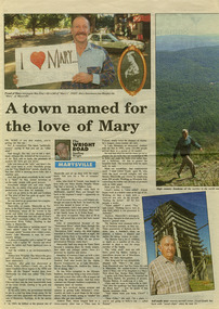 Marysville & District Historical Society
Newspaper (Item) - Newspaper article, Geoffrey Wright, A town named for the love of Mary, Unknown
A digital copy of a newspaper article on Marysville and some of its history as well as some local identities. This article was written by Geoffrey Wright for THE WRIGHT ROAD.A digital copy of a newspaper article on Marysville and some of its history as well as some local identities.marysville, victoria, australia, geoffrey wright, lake mountain, wood's point, gaffney's creek, goulburn river, john steavenson, mary martha murphy, yarra track, barton bros store, j l gould sawmill -
 Whitehorse Historical Society Inc.
Administrative record - Council Minutes, Lango Lane, Mitcham, 20/11/2006
The lane behind 699 Whitehorse Road, Mitcham needed a name and the Wurundjeri tribe was consulted to provide one, Their choice was Lango Lane meaning "edge".The lane behind 699 Whitehorse Road, Mitcham needed a name and the Wurundjeri tribe was consulted to provide one and their choice was Lango Lane meaning "edge".lango lane, whitehorse road mitcham no 699, wurundjeri, lanes -
 Kiewa Valley Historical Society
Bottle - Cream, 1935
Cream came in bottles bought at the local store or at a large city store on a shopping expedition. The shape of the bottles changed as did the stopper used to seal it. The amount of liquid was measured in ounces and pints pre 1966. History of J. Kikpatrick, Waverley, East malvern.Historical: Change of bottles - shape, size, stopper, embossing and use. Aesthetic; Display showing embossing and shapeClear small glass cream bottle with heavy embossing on both sides. Inside the opening is a rim to hold a cardboard disc used to seal the bottle. The sides are straight half way up then taper to the opening. One side: The Property of / J. Kilpatrick (half moon on top) / Waverly Road (across middle) / East Malvern (half moon on bottom) Other side: Please / wash / & / Return (also curved with & in the middle) Along side at base: "Contents not less than 8 ozs." Base: Across middle M93 above M, and AGM below. cream, dairy, milkbar, bottle, household -
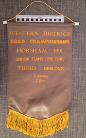 Geelong Cycling Club
Banner
This banner is one of the many awarded in the Western District of Victoria for competitive cycling races from the 1920s onwards. Notably Russell Mockridge was one of the first from the Geelong Cycling Club to compete in the Western District Road Races.This banner is one of the many awarded in the Western District of Victoria for competitive cycling races from the 1920s onwards.Grey coloured satin cloth banner. The banner has a yellow fringe attached to the bottom of it and has yellow embossed inscriptions. There is a long yellow cord supported by a piece of dowel threaded through the top of the banner. "Western District/Road Championships/Horsham 1991/Senior/Teams Time Trial/Third Geelong/C.Dowling/C.Bain"geelong cycling club; banner; western district; road championships; horsham; senior; teams time trial; c.dowling; c.bain; -
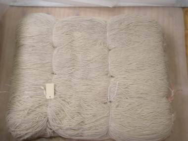
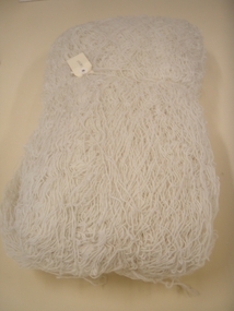 National Wool Museum
Skein
Acquired at closure of Brintons Carpets' Fellmonger Road factory.W7196 Page 1 of a history of Brintons Carpets. Page 2 of a history of Brintons Carpets. A list of catalogues/items in the Brintons Collection donated after closure of Fellmongers Road factory in July 2008.wool industry, brintons australia pty ltd brintons pty ltd (geelong) brintons ltd (uk), carpet -
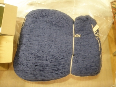 National Wool Museum
Skein
Acquired on closure of Brintons Carpets' Fellmonger Road factory.W7197 Page 1 of a history of Brintons Carpets. Page 2 of a history of Brintons Carpets. A list of catalogues/items in the Brintons Collection donated after closure of Fellmongers Road factory in July 2008.wool industry, brintons australia pty ltd brintons pty ltd (geelong) brintons ltd (uk), carpet -
 National Wool Museum
Skein
Acquired at closure of Brintons Carpet's Fellmonger Road factory.W7198 Page 1 of a history of Brintons Carpets. Page 2 of a history of Brintons Carpets. A list of catalogues/items in the Brintons Collection donated after closure of Fellmongers Road factory in July 2008.wool industry, brintons australia pty ltd brintons pty ltd (geelong) brintons ltd (uk), carpet -
 Kew Historical Society Inc
Photograph - Studley Park, 1937
Those sections of Studley Park closest to the River Yarra were set aside as parkland in the 1850s. After initial discussions about whether it was a suitable site for a Government House, much of the land was instead gazetted in the 1860s as the location for a new lunatic asylum, to expand overcrowded mental health facilities at the Yarra Bend Asylum on the other side of the river at Fairfield. Those sections of Studley Park bounded by the Yarra River, Studley Park Road, Princess Street and Fellows Street were subdivided and sold at the Crown Land Sales in 1851. Much of this urban area remained open farmland until the twentieth century, apart from mansions, largely located along the main roads.Original, black and white positive print of what is said to represent Studley Park in 1937. If the attribution and date is literally to be understood, then it would appear that the photograph may have been taken from the Kew side of the river looking across to open farmland in the Yarra Bend Park. If the designation of Studley Park is to be understood more loosely, then it might be a view of what is now East Kew, taken from a section of Kilby Road. Inscribed verso: "Studley Park 1937" studley park -- kew (vic.) -
Port Melbourne Historical & Preservation Society
Document - Label, McPhillimy's Famous Cough Drops, c. 1970
Produced by Lagoon confectioners when in Albert Road (i.e. pre 1970s), purchased at an Ephemera fairLarge red and black label, taken from a 4 1/2 lb tin of McPhillimy's Famous Cough Drops, manufactured by Lagoon Confectioners when in Albert Roadbusiness and traders - confectioners, industry - food, lagoon confectioners pty ltd -
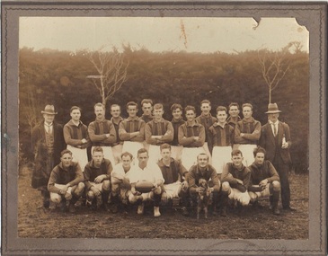 Emerald Museum & Nobelius Heritage Park
B/W Photograph, Freddy Woermer, 1931 Emerald Football Club Premiers, 1931
Emerald Football Club won the district Premiership in 1931, and had this photograph taken by Ferdinand ("Freddy") Woermer, whose stamp is on the reverse of the mounting. Woermer lived in a humpy on the Monbulk-Seville Road, Silvan (then Burleigh), and worked around the district as a professional photographer. He used a hollowed tree stump as a dark room for developing photographs.This photograph has double significance. On the one hand, it depicts the premiership team members in 1931. On the other, it is the work of F Woermer, a figure of some interest in the area.B/W photograph of the 1931 Emerald Football Club Premiers team, 22 people in all. Woodlands in background. Photo is glued to heavy cardboard.Rear: Stamp of manufacturers "F Woermer, Silvan Vic" and handwritten date "1931"emerald football club, woermer -
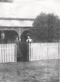 Sunbury Family History and Heritage Society Inc.
Photograph, The Fanning family, c1890
The Fanning Family home, 'Sunnyside', was built in Loemans Road after William Patrick Fanning migrated from Thurles, Co Tipperary, Ireland. He was one of the early farmers in Bulla. He and his wife, Catherine had five children. Since he and his wife died their descendants continued to live at 'Sunnyside' in Bulla. The Fanning family were one of the early settlers in Bulla during European settlement.A photocopied black and white non-digital photograph of a man, lady and young girl standing behind a picket fence outside a weatherboard Victorian cottage with a galvanised iron roof. The family are smartly dressed in clothes fashionable in the 1890s.A label with 'The Fanning Family' printed on it has been stuck on the side of the photograph.'sunnyside', bulla bulla, fanning family, loemans road -
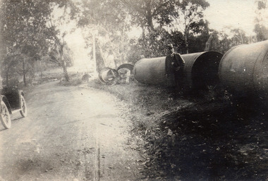 Mt Dandenong & District Historical Society Inc.
Photograph, At Site of Silvan Dam Pipes c1924, c1924
Man posed for photograph beside large water pipes destined for Silvan Dam. Car is parked at side of road.Black and white photograph with well dressed man in suit and hat standing beside large water pipes beside a treed road. Part of a car is visible to the left.silvan dam, pipe -
 Rutherglen Historical Society
Image, c1990
This photograph is of the side of the main building of the Gold Battery with workshop at rear (now demolished). Beside building is a hand windlass, along with some old pulleys and various parts. This is one of a series of photographs of the Rutherglen Gold Battery. The battery's purpose was to crush quartz from nearby quartz reefs and extract gold from within. The battery was erected in 1908 and consists of a five-head battery, Wilfrey table, Bergin pan, portable steam engine and shed. The battery was restored in 2011/12 and can be viewed daily between 9.00am and 5.00pm. See website for details.Colour photograph of the side of a corrugated iron building with a smaller building at the left, and a number of pieces of machinery next to the buildinggold battery, gold processing -
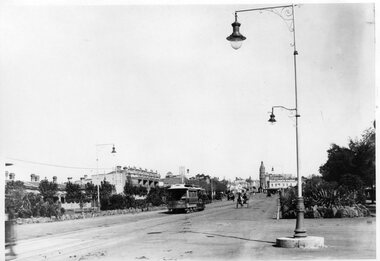 Melbourne Tram Museum
Photograph - Black and White - St Kilda Road, looking south to St Kilda Junction
St Kilda Road, looking south to St Kilda Junction from near Peel Street. Photo shows a number of horse drawn vehicles and one cable tram on its way to St Kilda Beach. In the background is the Junction Hotel and the Corner Hotel advertising Black and White whiskey. There are a number of gas street lamps in the view.Yields information about St Kilda Road and St Kilda Junction about 1900.Black and white photograph - St Kilda Road, looking south to St Kilda Junction, c1900.tramways, trams, st kilda road, st kilda junction, cable trams, corner hotel, junction hotel -
![Map, Plan of Town Allotments Bacchus Marsh [1891-1897]](/media/collectors/5e461d8021ea67224c82f2a1/items/66acc1c90c778f9f64a3daec/item-media/66acc3990c778f9f64a3e09b/item-fit-380x285.jpg) Bacchus Marsh & District Historical Society
Bacchus Marsh & District Historical SocietyMap, Plan of Town Allotments Bacchus Marsh [1891-1897]
This plan of town allotments in Lerderderg Street and Bennett Street also includes the location of many of the buildings, shops, businesses and houses which were present in the retail and business area of Bacchus Marsh in the 1890s. The precise date of the plan is not known but it must be sometime between 1891 and 1897. The Post Office and the Wesleyan Church are both shown on this plan. Both of these were constructed in 1890. The plan does not show the Baptist Church in Main Street which was constructed in 1898. Hence the date is sometime between 1891 and 1897.This plan of Bacchus Marsh is one of the most detailed visual representations of the location of shops, businesses and houses in the central part of Bacchus Marsh. It provides very precise locations of most of the shops and houses in the town in the 1890s. A single page paper plan showing allotments of land fronting Lerderderg and Bennett Street. Buildings, businesses and houses along most of the streets are identified by hand written annotations. Streets identified on plan: Lerderderg Street - Bennett Street - Main Street - Gell Street - Young Street - Graham Street. Physical boundaries of the map are: North border - Lerderderg Street - South border - Main Street - West border Gell Street - East border - Young Street. The plan is pasted into a bound volume containing 76 maps or plans in total. bacchus marsh victoria maps, shops bacchus marsh -
Federation University Historical Collection
Photograph - Computer, Ballarat Institute of Advanced Education computer, c1970
Photographs taken of the first computer of Ballarat School of Mines / Ballarat Institute of Advanced Education Mount Helen Campus. This mainframe computer was purchased in 1969 for $116,000 and set up in the First Stage Engineering building (later F Building). It was the first operational teaching facility on the new campus. The initial computer centre staff were Arch McKinnon ad Manager and Judy Wilson as Key Punch Operator.. In 1972 Brian Dixon operated this computer for a night or two a week. He obtained an operators certificate as part of a Maths course at Ballarat College of Advanced Education, and lecturer Arch McKinnon offered Brian Dixon a night job.Three women in a main frame computer room being overseen by a man computer, key punch, punch cards, icl1901a, g. durand, judith wilson, vivvian gay, jane henderson, brian dixon -
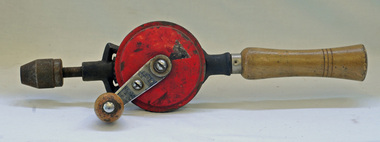 Orbost & District Historical Society
hand drill, Mid 20th century
This item is an example of a domestic woodworking tool commonly used before the widespread use of power tools.A hand drill with three wooden handles. The main gear is painted red.On right handle - Made in China with some Chinese lettering.tool hand-drill -
 Bendigo Historical Society Inc.
Photograph - CASTLEMAINE GAS COMPANY COLLECTION: PHOTO MAIN GAS VALVE
Date and Location Unknown - Main Gas Valves in a Fenced off Paddockorganisation, industry, gas and fuel -
Tatura Irrigation & Wartime Camps Museum
Booklet, Nagambie Anniversary Book
Artist's impression of Nagambie's Historical streetscape and bridges over past years.Cream cover, green writing. Sketch of buildings in main street, Nagambie.nagambie tourism inc, books, history, local, nagambie streetscape, nagambie bridges -
University of Melbourne, Burnley Campus Archives
Document, Calendar of Events 1991, 1991
Calendar of main College events and Centenary celebrations. 4 copies + photocopycentenary, 1991, celebrations, calendar -
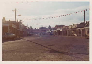 Clunes Museum
Photograph
CELEBRATIONS IN CLUNESCOLOURED PHOTOGRAPH OF CLUNES MAIN STREET WITH FLAGS ACROSS FRASER STREET.local history, photography, photographs, clunes township